Natural Resources
Conservation Service
Ecological site QX191X01X507
Very Poorly Drained Mucky Clay
Last updated: 6/12/2025
Accessed: 10/19/2025
General information
Provisional. A provisional ecological site description has undergone quality control and quality assurance review. It contains a working state and transition model and enough information to identify the ecological site.
MLRA notes
Major Land Resource Area (MLRA): 191X–High Limestone Plateaus of the Mariana Islands
This MLRA consists of the northern half of Guam and the islands of Saipan), Tinian, Rota, and Aguijan. Topography consists mostly of limestone plateaus. The highest elevations are 1,700 feet (520 meters) on Rota, 1,485 feet (450 meters) on Saipan, 655 feet (200 meters) on Tinian, and 860 feet (260 meters) in the northern part of Guam. The limestone plateaus were uplifted by tectonic activity. Deeply weathered volcanic rock is exposed on some ridges and slopes. Average annual rainfall is 100 inches (2,540 millimeters) on northern Guam and 80 inches (2,030 millimeters) on Saipan, Tinian, Aguijan, and Rota. The rainy season occurs from July through November; the dry season occurs from December through June. Trade winds blow from the northeast. Average annual temperature is 79 degrees F (26 degrees C). Typhoons are frequent. Soils are Alfisols, Andisols, Entisols, Mollisols, or Oxisols. The dominant soil moisture regime is ustic. The soil temperature regime is isohyperthermic. Native vegetation consists of mixed tropical hardwoods; introduced white leadtree or tangantangan trees (Leucaena leucocephala) are abundant. Introduced deer, pigs, goats, and water buffalo are common (USDA-NRCS, 2006). The main human disturbance is clearing land for cultivation. Feral pigs, feral cattle, brown tree snakes, stray dogs (Boonie dogs), and introduced deer are destructive to the native forest (Amand, 2000; CNMI SWARS Council, 2010; Donnegan et al., 2011; Liske-Clark, 2015; Willsey et al., 2019).
Classification relationships
This ecological site occurs within Major Land Resource Area (MLRA) 191 – High Limestone Plateaus of the Mariana Islands.
Ecological site concept
This ecological site occurs on the island of Guam in the Mariana Islands. It occurs on nearly level (0 to 3 percent slopes) coastal valley bottoms and plains at elevations ranging from 0 to 20 feet (0 to 6 meters). Note: all the Inarajan Variant delineations are right at the coast and mostly 0 to 10 feet elevation, some 0 to 20 feet, and to 40 feet in extremes of minor importance, according to soil map unit extents and the elevation isohyets.
Soils are very deep, very poorly drained Inceptisols (Vertic Endoaquepts) that formed in alluvium from mixed sources. Soil temperature regimes are isohyperthermic; soil moisture regimes are aquic. Saline groundwater occurs in large areas (EC is 2 to 8 mmhos/centimeters). Mean annual precipitation is about 90 inches (2,285 millimeters). Water runoff is very high, permeability slow. Available water-holding capacity is moderate (6 inches or 15 centimeters). The surface soil (2 inches or 5 centimeters deep) is mucky clay; beneath this is clay. The water table fluctuates between the soil surface and 18 inches (45 centimeters) below the soil surface. Flooding is frequent and brief during the rainy season. Most of the area is vegetated by wetland grasses and sedges and, in some locations, mangrove forests. The soils likely are inundated by ocean tides twice daily, as suggested by the Guam Soil Survey descriptions of flooding and ponding for this soil; however, the Soil Survey is not clear on this point (USDA-SCS, 1988).
Associated sites
| QX191X01X503 |
Very Shallow to Moderately Deep Soils on Limestone Plateaus Soils of QX191X01X503 (The Very Shallow to Moderately Deep Soils on Limestone Plateaus Ecological Site) formed in fine materials over porous coralline or argillaceous limestone. Effective rooting depth is 8 to 26 inches, available water holding capacity is very low to low (2 to 3 inches), base saturation is high, pH is 6.5 to 7.9, and there is no aluminum toxicity. Areas not farmed are vegetated by mostly introduced grass, forb, and tree species, with some areas of native upland forest. Tangantangan (Leucaena leucocephala) is abundant in places. Soils of QX191XO1X507 (The Very Poorly Drained Mucky Clay Ecological Site) occurs on coastal valley bottoms and plains. Soils formed in alluvium from mixed sources, have aquic moisture regimes, the water table occurs between 0 and 18 inches (45 centimeters) below the soil surface, they have slightly to moderately saline ground water (2 to 8 mmhos/centimeters) and frequent flooding. Most of the area is vegetated by wetland grasses and sedges and, in some locations, mangrove forest. |
|---|---|
| QX191X01X505 |
Very Low Available Water Capacity Soils on Limestone Plateaus and Escarpments Soils of QX191X01X505 (The Very Low Available Water Capacity Soils on Limestone Plateaus and Escarpments Ecological Site) formed in fine materials over porous coralline limestone. Effective rooting depth is 2 to 16 inches (5 to 40 centimeters); available water holding capacity is very low (1 inch). Most of the area is vegetated by native forest. These soils are limited to an area that is often shrouded in clouds and fog. Moisture is added to the soil by fog drip, which maintains soils in moist condition most of the time. These soils are mostly forested with native species. Soils of QX191XO1X507 (The Very Poorly Drained Mucky Clay Ecological Site) occur on coastal valley bottoms and plains. Soils formed in alluvium from mixed sources, are very poorly drained, have aquic moisture regimes, the water table occurs between 0 and 18 inches (45 centimeters) below the soil surface, they have slightly to moderately saline ground water (2 to 8 mmhos/centimeters) and frequent flooding. Most of the area is vegetated by wetland grasses and sedges and, in some locations, mangrove forest. |
| QX192X01X501 |
Somewhat Poorly Drained Alluvium Soils of QX192X01X501 (The Somewhat Poorly Drained Alluvium Ecological Site) occur in stream channels, depressions, and seeps on volcanic uplands. The soils, which formed in alluvium from volcanic tuff and tuff breccia, are somewhat poorly drained, have effective rooting depths greater than 60 inches, high available water holding capacity, shallow water tables during the rainy season, and are rarely flooded. Most of the area is vegetated by wetland forest, grasses, and sedges. Soils of QX191XO1X507 (The Very Poorly Drained Mucky Clay Ecological Site) occur on coastal valley bottoms and plains. Soils formed in alluvium from mixed sources, are very poorly drained, have aquic moisture regimes, the water table occurs between 0 and 18 inches (45 centimeters) below the soil surface, they have slightly to moderately saline ground water (2 to 8 mmhos/centimeters), and frequent flooding. Most of the area is vegetated by wetland grasses and sedges and, in some locations, mangrove forest. |
| QX191X01X506 |
Somewhat Poorly and Poorly Drained Valley Bottoms and Coastal Plains Soils of QX191X01X506 (The Somewhat Poorly and Poorly Drained Valleys and Alluvial Coastal Plains Ecological Site) are in broad river valley bottoms and narrow coastal plains. Soils formed in alluvium or beach deposits, are somewhat poorly and poorly drained, have aquic moisture regimes, moderately deep (about 30 inches) water tables, and are occasionally flooded. Most of the area is vegetated by grasses, forbs, and wetland forest. Soils of QX191XO1X507 (The Very Poorly Drained Mucky Clay Ecological Site) occur on coastal valley bottoms and plains. Soils formed in alluvium from mixed sources, are very poorly drained, have aquic moisture regimes, the water table is between 0 and 18 inches (45 centimeters) below the soil surface, they have slightly to moderately saline ground water (2 to 8 mmhos/centimeters) and frequent flooding. Most of the area is vegetated by wetland grasses and sedges and, in some locations, mangrove forest. |
| QX192X01X003 |
Shallow Soils on Volcanic Uplands Soils of QX192X01X003 (The Shallow Soils on Volcanic Upland Ecological Site) are shallow (less than 15 inches), well drained Mollisols with very low (2 inches) available water holding capacity, high base saturation, and no aluminum toxicity that support upland grasses, forbs, and forest. Soils of QX191XO1X507 (The Very Poorly Drained Mucky Clay Ecological Site) occur on coastal valley bottoms and plains. Soils formed in alluvium from mixed sources, are very poorly drained, have aquic moisture regimes, the water table is between 0 and 18 inches (45 centimeters) below the soil surface, they have slightly to moderately saline ground water (2 to 8 mmhos/centimeters) and frequent flooding. Most of the area is vegetated by wetland grasses and sedges and, in some locations, mangrove forest. |
Similar sites
| QX191X01X005 |
Very Poorly Drained Muck Soils of QX191X01X005 (The Very Poorly Drained Muck Ecological Site) occur in depressions near sea level. They are very deep (greater than 72 inches) organic soils with fresh to saline groundwater (EC is 8 to 16 mmhos/centimeters) with a water table that occurs at soil surface (about 0 inches). Flooding is frequent, ponding is rare. Most of the area is vegetated by marsh grasses and, in a few locations, small stands of sea hibiscus (Hibiscus tiliaceus) or mangrove (Rhizophora spp.) forest. Soils of QX191XO1X507 (The Very Poorly Drained Mucky Clay Ecological Site) occur on coastal valley bottoms and plains. They formed in alluvium from mixed sources, are very poorly drained, have aquic moisture regimes, the water table is between 0 and 18 inches (45 centimeters) below the soil surface, they have slightly to moderately saline ground water (2 to 8 mmhos/centimeters) and frequent flooding. Most of the area is vegetated by wetland grasses and sedges and, in some locations, mangrove forest. |
|---|
Table 1. Dominant plant species
| Tree |
(1) Rhizophora apiculata |
|---|---|
| Shrub |
Not specified |
| Herbaceous |
(1) Acrostichum aureum |
Legacy ID
F191XY507MP
Click on box and path labels to scroll to the respective text.
Ecosystem states
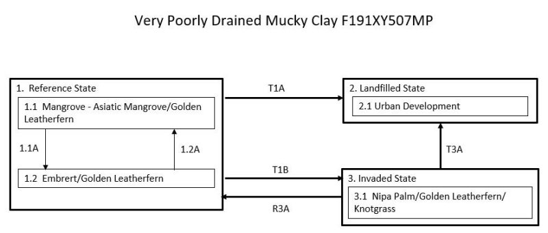
| T1A | - | The Reference State (1) transitions to the Landfilled State (2) by intentional filling of the swamp to produce construction sites. |
|---|---|---|
| T1B | - | The Reference State (1) transitions to the Invaded State (3) with long-term, severe human disturbance such as land clearing or removal of large amounts of wood. Introduced plant species can invade these sites and maintain themselves for long periods of time. |
| R3A | - | The Invaded State (3) can be resotred back to the Reference State (1). Mangrove forests have been restored to suitable habitats in many places in the world. Replanting of mangrove trees and control of weedy species are necessary. |
| T3A | - | The Invaded State (3) transitions to the Landfilled State (2) by intentional filling of the swamp to produce construction sites. |
State 1 submodel, plant communities
| 1.1A | - | Community phase 1.1 shifts to phase 1.2 due to heavy damage and tree mortality from storms or overharvesting of wood. |
|---|---|---|
| 1.2A | - | Community phase 1.2 reverts to phase 1.1 with gradual regrowth of mangroves when given adequate time to recover after disturbance. |