Natural Resources
Conservation Service
Ecological site QX191X01X503
Very Shallow to Moderately Deep Soils on Limestone Plateaus
Last updated: 6/12/2025
Accessed: 10/19/2025
General information
Provisional. A provisional ecological site description has undergone quality control and quality assurance review. It contains a working state and transition model and enough information to identify the ecological site.
MLRA notes
Major Land Resource Area (MLRA): 191X–High Limestone Plateaus of the Mariana Islands
This MLRA consists of the northern half of Guam and the islands of Saipan), Tinian, Rota, and Aguijan. Topography consists mostly of limestone plateaus. The highest elevations are 1,700 feet (520 meters) on Rota, 1,485 feet (450 meters) on Saipan, 655 feet (200 meters) on Tinian, and 860 feet (260 meters) in the northern part of Guam. The limestone plateaus were uplifted by tectonic activity. Deeply weathered volcanic rock is exposed on some ridges and slopes. Average annual rainfall is 100 inches (2,540 millimeters) on northern Guam and 80 inches (2,030 millimeters) on Saipan, Tinian, Aguijan, and Rota. The rainy season occurs from July through November; the dry season occurs from December through June. Trade winds blow from the northeast. Average annual temperature is 79 degrees F (26 degrees C). Typhoons are frequent. Soils are Alfisols, Andisols, Entisols, Mollisols, or Oxisols. The dominant soil moisture regime is ustic. The soil temperature regime is isohyperthermic. Native vegetation consists of mixed tropical hardwoods; introduced white leadtree or tangantangan (Leucaena leucocephala) are abundant. Introduced deer, pigs, goats, and water buffalo are common (USDA-NRCS, 2006). The main human disturbance is clearing land for cultivation. Feral pigs, feral cattle, brown tree snakes, stray dogs (Boonie dogs), and introduced deer are destructive to the native forest (Amand, 2000; CNMI SWARS Council, 2010; Donnegan et al., 2011; Liske-Clark, 2015; Willsey et al., 2019).
Classification relationships
This ecological site occurs within Major Land Resource Area (MLRA) 191 – High Limestone Plateaus of the Mariana Islands.
Ecological site concept
This ecological site occurs on the islands of Guam, Saipan, Tinian, Rota, and Aguijan in the Mariana Islands. It occurs on nearly level to steep (0 to 30 percent slopes) limestone plateaus at elevations ranging from 10 to 1,476 feet (3 to 450 meters) (USDA-SCS, 1988; USDA-SCS, 1989).
Soils range from very shallow to the shallower range of the moderately deep class. They are well drained Mollisols (Argiustolls and Haplustolls), Alfisols, and Entisols that formed in sediment or residuum over coralline limestone or argillaceous limestone. Some phases consist of fill deposited over the natural soil surface. Soil temperature regimes are isohyperthermic; soil moisture regimes are ustic. Average annual precipitation is 88 inches (2,240 millimeters) and ranges from 78 to 95 inches (1,980 to 2,410 millimeters) (Prism, 2006). Water runoff is predominately low; permeability is slow to moderately rapid. Effective rooting depth ranges from 2 to 20 inches (5 to 50 centimeters); some roots occur in cracks in the underlying limestone. Available water-holding capacity is 2 to 3 inches (3 to 10 centimeters) in the upper 40 inches (100 centimeters) of soil (USDA-SCS, 1988; USDA-SCS, 1989). Areas not farmed are vegetated by mostly introduced grass, forb, and tree species, with some areas of native forest. Tangantangan (Leucaena leucocephala) is abundant in places (Amidon et al., 2017; Falanruw et al., 1989; Fosberg, 1960; Liu and Fischer, 2008; Stone, 1970; Wagner and Grether, 1948; Willsey et al., 2019).
Associated sites
| QX192X01X003 |
Shallow Soils on Volcanic Uplands Soils of QX192X01X003 (The Shallow and Shallow Soils on Volcanic Uplands Ecological Site) formed in volcanic materials, have effective rooting depths from 4 to 15 inches, and have very low available water holding capacity. Most of the area is vegetated by grasses, forbs, and forest. Soils of QX191X01X503 (The Very Shallow to Moderately Deep Soils on Limestone Plateaus Ecological Site) formed in fine materials over porous coralline or argillaceous limestone. Effective rooting depth is 2 to 20 inches and available water holding capacity is very low to low. Areas not farmed are vegetated by mostly introduced grass, forb, and tree species, with some areas of native upland forest. Tangantangan is abundant in places. |
|---|---|
| QX191X01X505 |
Very Low Available Water Capacity Soils on Limestone Plateaus and Escarpments Soils of QX191X01X505 (The Very Low Available Water Capacity Soils on Limestone Plateaus and Escarpments Ecological Site) occur on plateaus. They are well drained, shallow, very-cobbly clays and cobbly clay loams with very low (1 inch) available water holding capacity. Sub surface soils contain 13 to 40 percent rock fragments greater than 3 inches. Most of the area is vegetated by native forest. Soils of QX191X01X503 (The Very Shallow to Moderately Deep Soils on Limestone Plateaus Ecological Site) also occur on limestone plateaus. They are well drained, very shallow to moderately deep (8 to 26 inches) clays, clay loams, and very gravelly sandy loams. Available water-holding capacity is very low (2 to 3 inches). Sub surface soils contain 0 to 13 percent rock fragments greater than 3 inches. Much of the area is farmed. Areas not farmed are vegetated by mostly introduced grass, forb, and tree species, with some areas of native upland forest. |
| QX191X01X506 |
Somewhat Poorly and Poorly Drained Valley Bottoms and Coastal Plains Soils of QX191X01X506 (The Somewhat Poorly and Poorly Drained Valleys and Alluvial Coastal Plains Ecological Site) are in broad river valley bottoms and alluvial coastal plains. They are poorly to somewhat poorly drained. They formed in alluvium or beach deposits, have aquic moisture regimes, shallow water tables, areas of slightly brackish groundwater, and are occasionally flooded. They have moderately high (4 inches) or high (5 inches) water holding capacity. Most of the area is vegetated by grasses, forbs, and wetland forest. Soils of QX191X01X503 (The Very Shallow to Moderately Deep Soils on Limestone Plateaus Ecological Site) occur on limestone plateaus. They are well drained, very shallow to moderately deep (8 to 26 inches) clays, clay loams and very gravelly sandy loams. Available water-holding capacity is very low (2 to 3 inches). Sub surface soils contain 0 to 13 percent rock fragments greater than 3 inches. Much of the area is farmed. Areas not farmed are vegetated by mostly introduced grass, forb, and tree species, with some areas of native upland forest. |
| QX191X01X004 |
Somewhat Poorly and Poorly Drained Limestone Basins Soils of QX191X01X004 (The Somewhat Poorly and Poorly Drained Limestone Basins Ecological Site) occur on basin floors; they rarely flood or pond. They are moderately deep and deep, somewhat poorly and poorly drained, have low to moderate (5 inches) available water holding capacity, and somewhat neutral to slightly basic soils (pH ranges from 5.8 to 7.0). Most of the area is vegetated by water- tolerant grasses and forest. Soils of QX191X01X503 (The Very Shallow to Moderately Deep Soils on Limestone Plateaus Ecological Site) occur on plateaus. They are well drained, very shallow to moderately deep (8 to 26 inches) clays, clay loams and very gravelly sandy loams. Available water-holding capacity is very low (2 to 3 inches). Sub surface soils contain 0 to 13 percent rock fragments greater than 3 inches. Much of the area is farmed. Areas not farmed are vegetated by mostly introduced grass, forb, and tree species, with some areas of native upland forest. |
| QX192X01X501 |
Somewhat Poorly Drained Alluvium Soils of QX192X01X501 (The Somewhat Poorly Drained Alluvium Ecological Site) occur in stream channels, depressions, and seeps on volcanic uplands. The soils, which formed in alluvium from volcanic tuff and tuff breccia, are somewhat poorly drained, have effective rooting depths greater than 60 inches, high available water holding capacity, shallow water tables during the rainy season, and are occasionally flooded. Most of the area is vegetated by wetland forest, grasses, and sedges. Soils of Soils of QX191X01X503 (The Very Shallow to Moderately Deep Soils on Limestone Plateaus Ecological Site) formed in fine mineral materials over porous coralline or argillaceous limestone. Soils have ustic moisture regimes, deep water tables, only fresh groundwater, and no flooding or ponding. Areas not farmed are vegetated by mostly introduced grass, forb, and tree species, with some areas of native upland forest. |
| QX191X01X005 |
Very Poorly Drained Muck Soils of QX191X01X005 (The Very Poorly Drained Muck Ecological Site) occurs in depressions on nearly level (0 to 2 percent) slopes at elevations ranging from 0 to 20 feet. The surface soil is 8 inches of muck over mucky clay loam. The soil moisture regimes are aquic; the soils are wet at the surface (0 inches). Groundwater varies from fresh to saline (EC 8 to 16 dS/m) depending on location. Flooding is frequent. Most of the area is vegetated by marsh grasses and, in a few locations, small stands of hibiscus (Hibiscus tiliaceus) or mangrove forest. Soils of QX191X01X503 (The Very Shallow to Moderately Deep Soils on Limestone Plateaus Ecological Site) formed in fine mineral materials over porous coralline or argillaceous limestone. Soils have ustic moisture regimes, deep water tables, only fresh groundwater, and no flooding or ponding. Areas not farmed are vegetated by mostly introduced grass, forb, and tree species, with some areas of native upland forest. |
| QX192X01X001 |
Moderately Deep Oxic Soils on Volcanic Uplands Soils of QX192X01X001 (The Very Deep Oxic Soils on Volcanic Uplands Ecological Site) formed in volcanic materials and have effective rooting depths greater than 60 inches, moderately high available water holding capacity, low base saturation, low pH, and aluminum toxicity. Most of the area is vegetated by Pacific silver grass or swordgrass (Miscanthus floridulus). Soils of QX191X01X503 (The Very Shallow to Moderately Deep Soils on Limestone Plateaus Ecological Site) formed in fine materials over porous coralline or argillaceous limestone. Effective rooting depth is 2.5 to 26 inches, available water holding capacity is very low to low, base saturation is high, pH is high, and there is no aluminum toxicity. Areas not farmed are vegetated by mostly introduced grass, forb, and tree species, with some areas of native upland forest. Tangantangan is abundant in places. |
| QX192X01X002 |
Deep Alfic Soils on Volcanic Uplands Soils of QX192X01X002 (The Deep Alfic Soils on Volcanic Uplands Ecological Site) formed in volcanic materials and have effective rooting depths greater of 40 to 60 inches, low available water holding capacity, fairly high base saturation, pH above 5.0, and no aluminum toxicity. Most of the area is vegetated by forest, grasses, and forbs. Soils of QX191X01X503 (The Very Shallow to Moderately Deep Soils on Limestone Plateaus Ecological Site) formed in fine materials over porous coralline or argillaceous limestone. Effective rooting depth is 2 to 20 inches, available water holding capacity is very low to low, base saturation is high, pH is high, and there is no aluminum toxicity. Areas not farmed are vegetated by mostly introduced grass, forb, and tree species, with some areas of native upland forest. Tangantangan is abundant in places. |
Similar sites
| QX191X01X502 |
Deep and Very Deep Soils on Limestone Plateaus QX191X01X502 (Deep and Very Deep Soils on Limestone Plateaus Ecological Site) formed in fine materials over porous coralline or argillaceous limestone. Effective rooting depth is 40 to 60 inches or deeper and available water holding capacity is moderate. Most of this ecological site is used for farmland; areas not farmed are vegetated by mostly introduced grass, forb, and tree species. Tangantangan (Leucaena leucocephala) is abundant in places. Soils of QX191X01X503 (Very Shallow to Moderately Deep Soils on Limestone Plateaus Ecological Site) formed in fine materials over porous coralline or argillaceous limestone. Effective rooting depth is 2 to 20 inches and available water holding capacity is very low to low. For both ecological sites, areas not farmed are vegetated by mostly introduced grass, forb, and tree species, with some areas of native upland forest. Tangantangan is abundant in places. |
|---|
Table 1. Dominant plant species
| Tree |
(1) Intsia bijuga |
|---|---|
| Shrub |
(1) Cycas circinalis |
| Herbaceous |
Not specified |
Legacy ID
F191XY503MP
Click on box and path labels to scroll to the respective text.
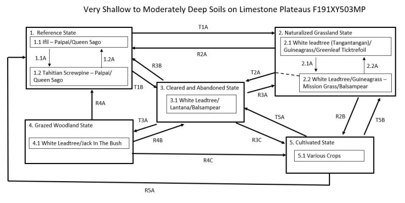
Ecosystem states
States 1, 5 and 2 (additional transitions)
| T1A | - | The Reference State (1) may transition to the Naturalized Grassland State (2) by mechanical clearing of the land followed by invasion by or planting of introduced forage species. |
|---|---|---|
| T1B | - | The Reference State (1) may transition to the Cleared and Abandoned State (3) by clearing the forest, temporary cultivation of crops, abandonment, and invasion by mostly introduced species. |
| R2A | - | The Naturalized Grassland State (2) can be restored to a facsimile of the Reference State (1) by suppressing the forage species and replanting native trees. |
| T2A | - | The Naturalized Grassland State (2) will transition to the Cleared and Abandoned State (3) from Community Phase 2.1 if the forage species are reduced in cover and vitality by heavy grazing before abandonment, allowing invasion of the site by weedy shrub, forb, and vine species. |
| R2B | - | The Naturalized Grassland State (2) can be restored to the Cultivated State (5) by killing forage species and cultivating for crops. |
| R3B | - | The Cleared and Abandoned State (3) can be restored to a facsimile of the Reference State (1) by brush and weed control followed by replanting of native trees. |
| R3A | - | The Cleared and Abandoned State (3) may be restored to the Naturalized Grassland State (2) by brush control, weed control, reseeding of desired forage species, and cutting back white leadtree (Leucaena leucocephala) to a shorter stature. |
| T3A | - | The Cleared and Abandoned State (3) will transition to the Grazed Woodland State (4) by continued growth and spread of white leadtree (Leucaena leucocephala), possible invasion by other tree species, and closure of the overstory to shade out most shrubs, forbs, and grasses. |
| R3C | - | The Cleared and Abandoned State (3) can be restored to the Cultivated State (5) by clearing the land and cultivating for crops. |
| R4A | - | The Grazed Woodland State (4) may be restored to a facsimile of the Reference State (1) by brush and weed control followed by replanting of native trees. |
| R4B | - | The Grazed Woodland State (4) may be restored to the Cleared and Abandoned State (3) by clearing and abandoning the site, allowing lower-growing species that require sunlight to invade. |
| R4C | - | The Grazed Woodland State (4) may be restored to the Cultivated State (5) by clearing the site, instituting weed control, and cultivating for crops. |
| T5B | - | The Cultivated State (5) may transition to the Naturalized Grassland State (2) by planting desired forages and eventually bringing grazing animals back to the site. |
| T5A | - | The Cultivated State (5) will transition to the Cleared and Abandoned State (3) by simple abandonment. |
State 1 submodel, plant communities
| 1.1A | - | Community phase 1.1 may shift to phase 1.2 by damage from powerful storms. |
|---|---|---|
| 1.2A | - | Community phase 1.2 reverts to phase 1.1 by regrowth of the original dominant species if given enough time between strong storm events. |
State 2 submodel, plant communities
| 2.1A | - | Community phase 2.1 will shift to phase 2.2 by overgrazing, which allows invasion by unpalatable grass and forb species. |
|---|---|---|
| 2.2A | - | Community phase 2.2 will revert to phase 2.1 with properly managed grazing, which allows desirable species to gradually regain dominance, and possible spot weed control. |