Natural Resources
Conservation Service
Ecological site QX191X01X505
Very Low Available Water Capacity Soils on Limestone Plateaus and Escarpments
Last updated: 6/12/2025
Accessed: 10/19/2025
General information
Provisional. A provisional ecological site description has undergone quality control and quality assurance review. It contains a working state and transition model and enough information to identify the ecological site.
MLRA notes
Major Land Resource Area (MLRA): 191X–High Limestone Plateaus of the Mariana Islands
This MLRA consists of the northern half of Guam and the islands of Saipan), Tinian, Rota, and Aguijan. Topography consists mostly of limestone plateaus. The highest elevations are 1,700 feet (520 meters) on Rota, 1,485 feet (450 meters) on Saipan, 655 feet (200 meters) on Tinian, and 860 feet (260 meters) in the northern part of Guam. The limestone plateaus were uplifted by tectonic activity. Deeply weathered volcanic rock is exposed on some ridges and slopes. Average annual rainfall is 100 inches (2,540 millimeters) on northern Guam and 80 inches (2,030 millimeters) on Saipan, Tinian, Aguijan, and Rota. The rainy season occurs from July through November; the dry season occurs from December through June. Trade winds blow from the northeast. Average annual temperature is 79 degrees F (26 degrees C). Typhoons are frequent. Soils are Alfisols, Andisols, Entisols, Mollisols, or Oxisols. The dominant soil moisture regime is ustic. The soil temperature regime is isohyperthermic. Native vegetation consists of mixed tropical hardwoods; introduced white leadtree or tangantangan trees are abundant. Introduced deer, pigs, goats, and water buffalo are common (USDA-NRCS, 2006). The main human disturbance is clearing land for cultivation. Feral pigs, feral cattle, brown tree snakes, stray dogs (Boonie dogs), and introduced deer are destructive to the native forest (Amand, 2000; CNMI SWARS Council, 2010; Donnegan et al., 2011; Liske-Clark, 2015; Willsey et al., 2019).
Classification relationships
This ecological site occurs within Major Land Resource Area (MLRA) 191 – High Limestone Plateaus of the Mariana Islands.
Ecological site concept
This ecological site occurs on the islands of Guam, Saipan, Tinian, Aguijan, and Rota in the Mariana Islands. It occurs on nearly level to very steep (0 to 99 percent slopes) limestone plateaus and escarpments at elevations ranging from 0 to 1570 feet (0 to 480 meters) (USDA-SCS, 1988; USDA-SCS, 1989).
Soils are very shallow to shallow, well drained Mollisols and Entisols that formed in sediment, colluvium, loess, and residuum over porous coralline limestone. Soil temperature regimes are isohyperthermic; soil moisture regimes are ustic. Average annual precipitation is about 91 inches (2,310 millimeters) and ranges from 80 to 101 inches (2,030 to 2,565 millimeters) (PRISM, 2006). Water runoff is very low to high; permeability is moderate or moderately rapid. Effective rooting depth ranges from 2 to 16 inches (5 to 40 cm). Available water-holding capacity is very low (1 inch) (USDA-SCS, 1988; USDA-SCS, 1989). Most of the area is vegetated by native forest. In windward low-elevation areas that receive salt spray the vegetation consists of shrubs and low trees (Amidon et al., 2017; Falanruw et al., 1989; Fosberg, 1960; Liu and Fischer, 2008; Stone, 1970; Wagner and Grether, 1948; Willsey et al., 2019).
Associated sites
| QX191X01X501 |
Excessively and Somewhat Excessively Drained Coastal Strand QX191X01X501 (The Excessively Drained Coastal Strand Ecological Site) formed in coral sand near the sea and fine materials over limestone where it borders inland limestone plateaus and escarpments. Effective rooting depth is 4 to 79 inches; available water holding capacity is very low to low (3 inches). Windborne salt spray and rare flooding by seawater affect the entire area. Soils of QX191X01X505 (The Very Low Available Water Capacity Soils on Limestone Plateaus and Escarpments Ecological Site) formed in fine materials over porous coralline limestone. Effective rooting depth is very shallow to shallow (2 to 16 inches); available water holding capacity is very low (1 inches). Most of the area is vegetated by native forest. This ecological site is limited to an area that is often shrouded in clouds and fog. Moisture is added to the soil by fog drip, which maintains soils in moist condition most of the time. Both ecological sites are mostly forested but with different, mostly native, species. Where they border each other, there is a mix of species from each ecological site. |
|---|---|
| QX192X01X001 |
Moderately Deep Oxic Soils on Volcanic Uplands Soils of QX192X01X001 (The Moderately Deep Oxic Soils on Volcanic Uplands Ecological Site) formed in volcanic materials and have effective rooting depths range from 16 to 45 inches, low to moderate available water holding capacity (2 to 7 inches), low base saturation, low pH, and aluminum toxicity. Most of the area is vegetated by Pacific silver grass or swordgrass (Miscanthus floridulus). Soils of QX191X01505 (The Very Low Available Water Capacity Soils on Limestone Plateaus and Escarpments Ecological Site) formed in fine materials over porous coralline limestone. Effective rooting depth is very shallow to shallow (2 to 16 inches); available water holding capacity is very low (1 inches). Most of the area is vegetated by native forest. This ecological site is limited to an area that is often shrouded in clouds and fog. Moisture is added to the soil by fog drip, which maintains soils in moist condition most of the time. |
| QX192X01X002 |
Deep Alfic Soils on Volcanic Uplands Soils of QX192X01X002 Very Deep Alfic Soils on Volcanic Uplands formed in volcanic materials and have effective rooting depth which are moderately deep (20 inches) to deep (40 inches); low available water holding capacity (4 inches), fairly high base saturation, pH above 5.0, and no aluminum toxicity. Most of the area is vegetated by forest, grasses, and forbs. Soils of QX191X01505 (The Very Low Available Water Capacity Soils on Limestone Plateaus and Escarpments Ecological Site) formed in fine materials over porous coralline limestone. Effective rooting depth is very shallow to shallow (2 to 16 inches); available water holding capacity is very low (1 inches). Most of the area is vegetated by native forest. This ecological site is limited to an area that is often shrouded in clouds and fog. Moisture is added to the soil by fog drip, which maintains soils in moist condition most of the time. |
| QX192X01X003 |
Shallow Soils on Volcanic Uplands Soils of QX192X01X003 (The Very Shallow and Shallow Soils on Volcanic Uplands Ecological Site) formed in volcanic materials, have effective rooting depth which are shallow (4 to 15 inches), and have very low available water holding capacity (2 inches). Most of the area is vegetated by grasses, forbs, and forest. Soils of Soils of QX191X01505 (The Very Low Available Water Capacity Soils on Limestone Plateaus and Escarpments Ecological Site) formed in fine materials over porous coralline limestone. Effective rooting depth is very shallow to shallow (2 to 16 inches); available water holding capacity is very low (1 inches). Most of the area is vegetated by native forest. This ecological site is limited to an area that is often shrouded in clouds and fog. Moisture is added to the soil by fog drip, which maintains soils in moist condition most of the time. |
| QX191X01X502 |
Deep and Very Deep Soils on Limestone Plateaus Soils of QX191X01X502 (The Deep and Very Deep Soils on Limestone Plateaus Ecological Site) formed in fine materials over porous coralline or argillaceous limestone. Effective rooting depth is 40 to 59 inches or deeper and available water holding capacity is low (4 to 6 inches). Most of this ecological site is used for farmland; areas not farmed are vegetated by mostly introduced grass, forb, and tree species. Tangantangan (Leucaena leucocephala) is abundant in places. Soils of QX191X01505 (The Very Low Available Water Capacity Soils on Limestone Plateaus and Escarpments Ecological Site) formed in fine materials over porous coralline limestone. Effective rooting depth is very shallow to shallow (2 to 16 inches); available water holding capacity is very low (1 inches). Most of the area is vegetated by native forest. This ecological site is limited to an area that is often shrouded in clouds and fog. Moisture is added to the soil by fog drip, which maintains soils in moist condition most of the time. |
| QX191X01X506 |
Somewhat Poorly and Poorly Drained Valley Bottoms and Coastal Plains Soils of QX191X01X506 (The Somewhat Poorly and Poorly Drained Valleys and Alluvial Coastal Plains Ecological Site) are in broad river valley bottoms and narrow coastal plains. Soils formed in alluvium or beach deposits, have aquic moisture regimes, moderately deep water tables, areas of slightly brackish groundwater, and are occasionally flooded. Most of the area is vegetated by grasses, forbs, and wetland forest. QX191X01505 (The Very Low Available Water Capacity Soils on Limestone Plateaus and Escarpments Ecological Site) formed in fine materials over porous coralline limestone. Effective rooting depth is very shallow to shallow (2 to 16 inches); available water holding capacity is very low (1 inches). Most of the area is vegetated by native forest. This ecological site is limited to an area that is often shrouded in clouds and fog. Moisture is added to the soil by fog drip, which maintains soils in moist condition most of the time. |
| QX191X01X002 |
Moderately Deep Alfic Soils on Volcanic Uplands Soils of QX191X01X002 (The Moderately Deep Alfic Soils on Volcanic Uplands Ecological Site) formed in volcanic uplands from residuum derived from andesitic marine tuff and tuffaceous breccia. They are highly weathered Alfisols that have fairly high base saturation, effective rooting depths of 20 to 40 inches, surface pH ranging from 5.5 to 5.8, and low (5 inches) available water holding capacity. Most of the area is vegetated by grasses, forbs, and mixed forest of introduced and native species. Swordgrass (Miscanthus floridulus) is present in some areas. white leadtree or Tangantangan (Leucaena leucocephala) is not abundant. Soils of QX191X01505 (The Very Low Available Water Capacity Soils on Limestone Plateaus and Escarpments Ecological Site) formed in fine materials over porous coralline limestone. Effective rooting depth is very shallow to shallow (2 to 16 inches); available water holding capacity is very low (1 inches). Most of the area is vegetated by native forest. This ecological site is limited to an area that is often shrouded in clouds and fog. Moisture is added to the soil by fog drip, which maintains soils in moist condition most of the time. |
| QX191X01X001 |
Moderately Deep Oxic Soils on Volcanic Uplands Soils of QX191X01X001onin volcanic uplands in residuum and colluvium derived from volcanic tuff and tuff breccia. They are highly weathered Oxisols that have low base saturation, a rooting depth of about 30 inches, surface pH of about 5.0 to 5.6, and aluminum toxicity that limits growth of most plant species. Most of the area is vegetated by swordgrass (Miscanthus floridulus). QX191X01505 (The Very Low Available Water Capacity Soils on Limestone Plateaus and Escarpments Ecological Site) formed in fine materials over porous coralline limestone. Effective rooting depth is very shallow to shallow (2 to 16 inches); available water holding capacity is very low (1 inches). Most of the area is vegetated by native forest. This ecological site is limited to an area that is often shrouded in clouds and fog. Moisture is added to the soil by fog drip, which maintains soils in moist condition most of the time. |
Table 1. Dominant plant species
| Tree |
(1) Artocarpus mariannensis |
|---|---|
| Shrub |
(1) Freycinetia reineckei |
| Herbaceous |
Not specified |
Legacy ID
F191XY505MP
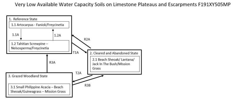
Click on box and path labels to scroll to the respective text.
| T1A | - | The Reference State (1) may transition to Cleared and Abandoned State (3) by clearing the forest, temporary cultivation of crops, abandonment, and invasion by mostly introduced species. |
|---|---|---|
| R2A | - | The Cleared and Abandoned State (2) can be restored to a facsimile of Reference State (1) by brush and weed control followed by natural reseeding or active replanting of native tree |
| T2A | - | The Cleared and Abandoned State (2) will transition to the Grazed Woodland State (3) by continued growth and spread of introduced and native tree species and closure of the overstory to shade out most shrubs, forbs, and grasses. |
| R3A | - | The Grazed Woodland State (3) may be restored to a facsimile of the Reference State (1) by brush and weed control followed by natural reseeding or active replanting of native trees. |
| R3B | - | The Grazed Woodland State (3) may be restored to the Cleared and Abandoned State (2) by clearing and abandoning the site, allowing lower-growing species that require sunlight to invade. |
State 1 submodel, plant communities
| 1.1A | - | Community phase 1.1 may shift to phase 1.2 by damage from powerful storms. |
|---|---|---|
| 1.2A | - | Community phase 1.2 reverts to phase 1.1 by regrowth of the original dominant species if given enough time between strong storm events. Browsing and grazing by introduced ungulates may inhibit this process by destruction of tree seedlings. |