Natural Resources
Conservation Service
Ecological site QX191X01X501
Excessively and Somewhat Excessively Drained Coastal Strand
Last updated: 6/12/2025
Accessed: 10/19/2025
General information
Provisional. A provisional ecological site description has undergone quality control and quality assurance review. It contains a working state and transition model and enough information to identify the ecological site.
MLRA notes
Major Land Resource Area (MLRA): 191X–High Limestone Plateaus of the Mariana Islands
This MLRA consists of the northern half of Guam and the islands of Saipan), Tinian, Rota, and Aguijan. Topography consists mostly of limestone plateaus. The highest elevations are 1,700 feet (520 meters) on Rota, 1,485 feet (450 meters) on Saipan, 655 feet (200 meters) on Tinian, and 860 feet (260 meters) in the northern part of Guam. The limestone plateaus were uplifted by tectonic activity. Deeply weathered volcanic rock is exposed on some ridges and slopes. Average annual rainfall is about 100 inches (2,540 millimeters) on northern Guam and about 80 inches (2,030 millimeters) on Saipan, Tinian, Aguijan, and Rota. The rainy season occurs from July through November; the dry season occurs from December through June. Trade winds blow from the northeast. Average annual temperature is 79 degrees F (26 degrees C). Typhoons are frequent. Soils are Alfisols, Andisols, Entisols, Mollisols, or Oxisols. The dominant soil moisture regime is ustic. The soil temperature regime is isohyperthermic. Native vegetation consists of mixed tropical hardwoods; introduced white leadtree or tangantangan trees (Leucaena leucocephala) are abundant. Introduced deer, pigs, goats, and water buffalo are common (USDA-NRCS, 2006). The main human disturbance is clearing land for cultivation. Feral pigs, feral cattle, brown tree snakes, stray dogs (Boonie dogs), and introduced deer are destructive to the native forest (Amand, 2000; CNMI SWARS Council, 2010; Donnegan et al., 2011; Liske-Clark, 2015; Willsey et al., 2019).
Classification relationships
This ecological site occurs within Major Land Resource Area (MLRA) 191 – High Limestone Plateaus of the Mariana Islands.
Ecological site concept
This ecological site occurs on the islands of Guam, Saipan, Tinian, and Rota in the Mariana Islands. It occurs on nearly level to gently sloping (0 to 10 percent slopes) shorelines of coastal plains and on low coastal limestone plateaus at elevations ranging from 0 to 30 feet (0 to 10 meters). It occurs mostly on the leeward coast, but it occurs also on the windward side of southern Guam near river outlets (USDA-SCS, 1988; USDA-SCS, 1989). It is most easily accessible on the northeastern coast of Rota.
Soils are Ustipsamments and Haplustolls that formed in water-deposited coral sand and coralline limestone deposited in narrow zones parallel to the seashore (USDA-SCS, 1988; USDA-SCS, 1989). Soil temperature regimes are isohyperthermic; soil moisture regimes are ustic. The average annual precipitation is 87 inches (2,210 millimeters) and ranges from 83 to 91 inches (2,110 to 2,310 millimeters) (PRISM, 2006). Water runoff is very low to low; permeability is moderate to rapid (USDA-SCS, 1988; USDA-SCS, 1989). Effective rooting depth ranges from 6 to greater than 72 inches (15 to 185 centimeters). In soils with shallow rooting depth, roots penetrate deeper along fractures in the underlying limestone. Available water-holding capacity is very low to low (0 to 3 inches). Windborne salt spray and rare flooding by seawater help determine the vegetation type. Much of this ecological site is forested, but thin bands of small herbaceous plants, shrubs, and scrub forest typically occupy the zone closest to the ocean (Amidon et al., 2017; Fosberg, 1960; Liu and Fischer, 2008; Plentovich et al., 2020; Stone, 1970; Wagner and Grether, 1948; Willsey et al., 2019).
Associated sites
| QX191X01X505 |
Very Low Available Water Capacity Soils on Limestone Plateaus and Escarpments Soils of QX191X01X505 (Very Low Available Water Capacity Soils on Limestone Plateaus and Escarpments Ecological Site) formed in fine materials over porous coralline limestone. They are well drained. Subsurface soils contain 0 to 40 percent rock fragments greater than 3 inches. Effective rooting depth is very shallow to shallow (6 to 16 inches); available water holding capacity is very low (1 inch). At lowest elevations or just above sea level, it can be affected by salt spray from the sea. Soils of QX191X01X501 (Excessively Drained Coastal Strand Ecological Site) formed in coral sand near the sea and fine materials over limestone where it borders inland limestone plateaus and escarpments. They are somewhat excessively to excessively drained. Effective rooting depth is very shallow to very deep (6 inches to greater than 72 inches); available water holding capacity is very low to low (0 to 3 inches). Windborne salt spray and rare flooding by seawater affect the entire area. Both ecological sites are mostly forested but with different, mostly native, species. Where they border each other, there is a mix of species from each ecological site. |
|---|---|
| QX191X01X503 |
Very Shallow to Moderately Deep Soils on Limestone Plateaus Soils of QX191X01X503 (Very Shallow to Moderately Deep Soils on Limestone Plateaus Ecological Site) formed in fine materials over porous coralline or argillaceous limestone. They are well drained. Subsurface soils contain 0 to 12 percent rock fragments greater than 3 inches. Effective rooting depth is very shallow or shallow (2 to 20 inches); available water holding capacity is very low to low (1 to 3 inches). QX191X01X501 (Excessively Drained Coastal Strand Ecological Site) formed in coral sand near the sea and fine materials over limestone where it borders inland limestone plateaus and escarpments. They are somewhat excessively to excessively drained. Effective rooting depth is shallow to very deep (6 to greater than 72 inches); available water holding capacity is very low to low (0 to 3 inches). Windborne salt spray and rare flooding by seawater affect the entire area. It is mostly forested, while much of the area of the Very Shallow to Moderately Deep Soils on Limestone Plateaus Ecological Site is farmed. Where not farmed, vegetation consists of mostly introduced grass, forb, and tree species. |
| QX191X01X502 |
Deep and Very Deep Soils on Limestone Plateaus Soils of QX191X01X502 (Deep and Very Deep Soils on Limestone Plateaus Ecological Site) occur on plateaus. They are deep and very deep and moderately well to well drained. Available water holding capacity is moderately low (3 to 6 inches). Most of this ecological site is used for farmland; areas not farmed are vegetated by mostly introduced grass, forb, and tree species. Soils of QX191X01X501 (Excessively and Somewhat Excessively Drained Coastal Strand Ecological Site) occur on shorelines; they experience occasional flooding. They are somewhat excessively and excessively drained loamy sands, with very low to low (0 to 3 inches) available water holding capacity, and basic soils (pH ranges from 7.4 to 8.4). Windborne salt spray and rare flooding by seawater affect the entire area. Much of this ecological site is forested, but thin bands of small herbaceous plants, shrubs, and scrub forest typically occupy the zone closest to the ocean. |
| QX191X01X506 |
Somewhat Poorly and Poorly Drained Valley Bottoms and Coastal Plains Soils of QX191X01X506 (Somewhat Poorly and Poorly Drained Valley Bottoms and Coastal Plains Ecological Site) occur on valley bottoms and alluvial coastal plains. They are somewhat poorly or poorly drained. They have low (5 to 6 inches) water holding-capacity. Most of the area is vegetated by grasses, forbs, and wetland forest. Soils of QX191X01X501 (Excessively and Somewhat Excessively Drained Coastal Strand Ecological Site) occur on shorelines; they experience occasional flooding. They are excessively and somewhat excessively drained loamy sands, with very low to low (0 to 3 inches) available water holding capacity, and basic soils (pH ranges from 7.4 to 8.4). Windborne salt spray and rare flooding by seawater affect the entire area. Much of this ecological site is forested, but thin bands of small herbaceous plants, shrubs, and scrub forest typically occupy the zone closest to the ocean. |
| QX191X01X001 |
Moderately Deep Oxic Soils on Volcanic Uplands Soils of QX191X01X001 (Moderately Deep Oxic Soils on Volcanic Uplands Ecological Site) occur on hillslopes; they do not flood or pond. They are moderately deep (about 33 inches), well drained, have moderately low (5 inches) available water holding capacity, and strongly to moderately acid (pH ranges from 5.0 to 5.6), and a base saturation that is less than 35 percent. Most of the area is vegetated by Pacific Island silvergrass or swordgrass (Miscanthus floridulus). Soils of QX191X01501 (Excessively and Somewhat Excessively Drained Coastal Strand Ecological Site) occur on shorelines; they experience occasional flooding. They are excessively and somewhat excessively well drained loamy sands, with very low to low (0 to 3 inches) available water holding capacity, and basic soils (pH ranges from 7.4 to 8.4). Windborne salt spray and rare flooding by seawater affect the entire area. Much of this ecological site is forested, but thin bands of small herbaceous plants, shrubs, and scrub forest typically occupy the zone closest to the ocean. |
| QX191X01X002 |
Moderately Deep Alfic Soils on Volcanic Uplands Soils of QX191X01X002 (Moderately Deep Alphic Soils on Volcanic Uplands Ecological Site) occur on uplands; they do not flood or pond. They are moderately deep, well drained, have low (5 inches) available water holding capacity, and slightly basic soils (pH ranges from 6.2 to 6.5) and a base saturation that is greater than or equal to 35 percent. Most of the area is vegetated by grasses, forbs, and mixed forest of introduced and native species. Soils of QX191X01X501 (Excessively and Somewhat Excessively Drained Coastal Strand Ecological Site) occur on shorelines; they experience occasional flooding. They are excessively and somewhat excessively well drained loamy sands, with very low (0 to 3 inches) available water holding capacity, and basic soils (pH ranges from 7.4 to 8.4). Windborne salt spray and rare flooding by seawater affect the entire area. Much of this ecological site is forested, but thin bands of small herbaceous plants, shrubs, and scrub forest typically occupy the zone closest to the ocean. |
| QX191X01X004 |
Somewhat Poorly and Poorly Drained Limestone Basins Soils of QX191X01X004 (Somewhat Poorly and Poorly Drained Limestone Basins Ecological Site) occur on basin floors; they rarely flood or pond. They are deep (40 to 60 inches), somewhat poorly and poorly drained, have low (6 inches) available water holding capacity, and slightly acid to slightly basic soils (pH ranges from 5.1 to 7.8). Most of the area is vegetated by water-tolerant grasses and forest. Soils of QX191X01X501 (Excessively and Somewhat Excessively Drained Coastal Strand Ecological Site) occur on shorelines; they experience occasional flooding. They are excessively and somewhat excessively well drained well drained loamy sands, with very low (0 to 3 inches) available water holding capacity, and basic soils (pH ranges from 7.4 to 8.4). Windborne salt spray and rare flooding by seawater affect the entire area. Much of this ecological site is forested, but thin bands of small herbaceous plants, shrubs, and scrub forest typically occupy the zone closest to the ocean. |
Table 1. Dominant plant species
| Tree |
(1) Hernandia sonora |
|---|---|
| Shrub |
Not specified |
| Herbaceous |
(1) Phymatosorus scolopendria |
Legacy ID
F191XY501MP
Click on box and path labels to scroll to the respective text.
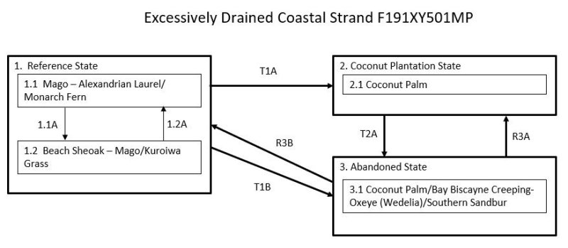
Ecosystem states
| T1A | - | The Reference State (1) transitions to the Coconut Plantation State (2) by removal of native vegetation and planting coconut palm (Cocos nucifera). |
|---|---|---|
| T1B | - | The Reference State (1) transitions to the Abandoned State (3) if cleared and abandoned. This allows heliophytes, both native and introduced, to temporarily cover the understory |
| T2A | - | The Coconut Plantation State (2) transitions to the Abandoned State (3) upon abandonment of coconut plantations, which are quickly invaded by low-statured, native and/or introduced heliophytes. |
| R3B | - | The Abandoned State (3) may be restored to the Reference State (1). The intensity of active restoration measures will be determined by the presence or lack of nearby native forest or, at least, some native trees as well as the density and species mix of grasses, vines, shrubs, and trees present on the site, especially if many competitive introduced species are present. |
| R3A | - | The Abandoned State (3) may be restored to the Coconut Plantation State (2) by land clearing, weed control, and replanting coconut palm (Cocos nucifera). |
State 1 submodel, plant communities
| 1.1A | - | Storms that disturb or kill trees causes a phase change from phase 1.1, which has all native tree species, to phase 1.2, which temporarily has an open stand of native trees with an understory of mostly native vines and grasses. |
|---|---|---|
| 1.2A | - | Community phase 1.2 will revert to phase 1.1 with gradual regrowth of a more diverse array of native species when given adequate time to recover after disturbance. |