Natural Resources
Conservation Service
Ecological site QX191X01X004
Somewhat Poorly and Poorly Drained Limestone Basins
Last updated: 6/12/2025
Accessed: 10/19/2025
General information
Provisional. A provisional ecological site description has undergone quality control and quality assurance review. It contains a working state and transition model and enough information to identify the ecological site.
MLRA notes
Major Land Resource Area (MLRA): 191X–High Limestone Plateaus of the Mariana Islands
This MLRA consists of the northern half of Guam and the islands of Saipan), Tinian, Rota, and Aguijan. Topography consists mostly of limestone plateaus. The highest elevations are 1,700 feet (520 meters) on Rota, 1,485 feet (450 meters) on Saipan, 655 feet (200 meters) on Tinian, and 860 feet (260 meters) in the northern part of Guam. The limestone plateaus were uplifted by tectonic activity. Deeply weathered volcanic rock is exposed on some ridges and slopes. Average annual rainfall is 100 inches (2,540 millimeters) on northern Guam and 80 inches (2,030 millimeters) on Saipan, Tinian, Aguijan, and Rota. The rainy season occurs from July through November; the dry season occurs from December through June. Trade winds blow from the northeast. Average annual temperature is 79 degrees F (26 degrees C). Typhoons are frequent. Soils are Alfisols, Andisols, Entisols, Mollisols, or Oxisols. The dominant soil moisture regime is ustic. The soil temperature regime is isohyperthermic. Native vegetation consists of mixed tropical hardwoods; introduced white leadtree or tangantangan trees (Leucaena leucocephala) are abundant. Introduced deer, pigs, goats, and water buffalo are common (USDA-NRCS, 2006). The main human disturbance is clearing land for cultivation. Feral pigs, feral cattle, brown tree snakes, stray dogs (Boonie dogs), and introduced deer are destructive to the native forest (Amand, 2000; CNMI SWARS Council, 2010; Donnegan et al., 2011; Liske-Clark, 2015; Willsey et al., 2019).
Classification relationships
This ecological site occurs within Major Land Resource Area (MLRA) 191 – High Limestone Plateaus of the Mariana Islands.
Ecological site concept
This ecological site occurs on the islands of Guam, Saipan, and Tinian in the Mariana Islands. It occurs in basin floor positions on limestone plateaus and coastal plains on nearly level to gently slopes (0 to 5 percent slopes) at elevations ranging from 0 to 500 feet (0 to 150 meters) (Amidon et al., 2017; Liu and Fischer, 2008; USDA-SCS, 1988; USDA-SCS, 1989).
Soils range from moderately deep to very deep. They are somewhat poorly or poorly drained Alfisols (Oxyaquic Vertic Paleustalfs) that formed in alluvial sediments and volcanic saprolite overlying limestone. Soil temperature regimes are isohyperthermic; soil moisture regimes are aquic. The mean annual precipitation is 92 inches (2,340 millimeters) (PRISM, 2006). Water runoff ranges from very low to very high; permeability is very slow. Effective rooting depth is 39 inches or greater (100 centimeters). Available water-holding capacity is low (about 5 inches or 13 centimeters). Groundwater is fresh (EC 0 mmhos/centimeter). The water table fluctuates seasonally between 0 and 36 inches or greater; (0 and 79 centimeters). Flooding is rare and brief. Ponding is rare but can occur for short to extended periods after heavy rainfall (USDA-SCS, 1988; USDA-SCS, 1989). Most of the area is vegetated by water-tolerant grasses and forest (Fosberg, 1960; USDA-SCS, 1988; USDA-SCS, 1989).
Associated sites
| QX191X01X503 |
Very Shallow to Moderately Deep Soils on Limestone Plateaus Soils of QX191X01X503 (The Very Shallow to Moderately Deep Soils on Limestone Plateaus Ecological Site) formed in fine materials over porous coralline or argillaceous limestone. Effective rooting depth is very shallow to moderately deep (2 to 20 inches) and available water holding capacity is very low. Areas not farmed are vegetated by mostly introduced grass, forb, and tree species, with some areas of native upland forest. White leadtree or tangantangan (Leucaena leucocephala) is abundant in places. Soils of QX191X01X004 (The Somewhat Poorly Drained and Poorly Drained Limestone Basins Ecological Site) occur in concave basins, depressions, and on foot slopes on limestone plateaus. Soils formed in mixed alluvium over limestone, have aquic moisture regimes, very shallow to moderately deep water tables, low available water capacity (5 inches), and undergo rare flooding and ponding. Most of the area is vegetated by water-tolerant grasses and forest. |
|---|---|
| QX191X01X505 |
Very Low Available Water Capacity Soils on Limestone Plateaus and Escarpments Soils of QX191X01X505 (Very Low Available Water Capacity Soils on Limestone Plateaus and Escarpments) formed in fine materials over porous coralline limestone. Effective rooting depth is very shallow to shallow (2 to 16 inches); available water holding capacity is very low (1 inch). Most of the area is vegetated by native forest. This ecological site is limited to an area that is often shrouded in clouds and fog. Moisture is added to the soil by fog drip, which maintains soils in moist condition most of the time. This ecological site is mostly forested with native species. Soils of QX191X01X004 (The Somewhat Poorly Drained and Poorly Drained Limestone Basins Ecological Site) occur in concave basins, depressions, and on foot slopes on limestone plateaus. Soils formed in mixed alluvium over limestone, have aquic moisture regimes, very shallow to moderately deep water tables, low available water capacity (5 inches), and undergo rare flooding and ponding. Most of the area is vegetated by water-tolerant grasses and forest. |
| QX192X01X003 |
Shallow Soils on Volcanic Uplands Soils of QX192X01X003 (The Shallow and Shallow Soils on Volcanic Upland Ecological Site) are very shallow to shallow with very low available water holding capacity (2 inches), high base saturation, and no aluminum toxicity that support upland grasses, forbs, and forest. Soils of QX191X01X004 (The Somewhat Poorly Drained and Poorly Drained Limestone Basins Ecological Site) occur in concave basins, depressions, and on foot slopes on limestone plateaus. Soils formed in mixed alluvium over limestone, have aquic moisture regimes, very shallow to moderately deep water tables, low available water capacity (5 inches), and undergo rare flooding and ponding. Most of the area is vegetated by water-tolerant grasses and forest. |
| QX191X01X502 |
Deep and Very Deep Soils on Limestone Plateaus Soils of QX191X01X502 (The Deep and Very Deep Soils on Limestone Plateaus Ecological Site) formed in fine materials over porous coralline or argillaceous limestone. Effective rooting depth is 40 to 72 inches and greater; available water holding capacity is low (4 to 6 inches). Much of the areas of both ecological sites is farmed. Where not farmed, vegetation consists of mostly introduced grass, forb, and tree species. White leadtree or tangantangan (Leucaena leucocephala) is abundant in places. Soils of QX191X01X004 (The Somewhat Poorly Drained and Poorly Drained Limestone Basins Ecological Site) occur in concave basins, depressions, and on foot slopes on limestone plateaus. Soils formed in mixed alluvium over limestone, have aquic moisture regimes, very shallow to moderately deep water tables, low available water capacity (5 inches), and undergo rare flooding and ponding. Most of the area is vegetated by water-tolerant grasses and forest. |
| QX191X01X503 |
Very Shallow to Moderately Deep Soils on Limestone Plateaus Soils of QX191X01X503 (The Very Shallow to Moderately Deep Soils on Limestone Plateaus Ecological Site) formed in fine materials over porous coralline or argillaceous limestone. Effective rooting depth is 2 to 20 inches; available water holding capacity is very low to low (1 to 4 inches). Areas not farmed are vegetated by mostly introduced grass, forb, and tree species, with some areas of native forest. White leadtree or tangantangan (Leucaena leucocephala) is abundant in places. Soils of QX191X01X004 (The Somewhat Poorly Drained and Poorly Drained Limestone Basins Ecological Site) occur in concave basins, depressions, and on foot slopes on limestone plateaus. Soils formed in mixed alluvium over limestone, have aquic moisture regimes, very shallow to moderately deep water tables, low available water capacity (5 inches), and undergo rare flooding and ponding. Most of the area is vegetated by water-tolerant grasses and forest. |
| QX191X01X002 |
Moderately Deep Alfic Soils on Volcanic Uplands Soils of QX191X01X002 (The Moderately Deep Alfic Soils on Volcanic Uplands Ecological Site) formed in residuum derived from andesitic marine tuff and tuffaceous breccia. They are highly weathered Alfisols that have fairly high base saturation, effective rooting depths between 20 and 40 inches, surface pH ranging from 5.5 to 5.8, and low available water holding capacity (5 inches). Most of the area is vegetated by grasses, forbs, and mixed forest of introduced and native species. Swordgrass (Miscanthus floridulus) is present in some areas. White leadtree or tangantangan (Leucaena leucocephala) is not abundant. Soils of QX191X01X004 (The Somewhat Poorly Drained and Poorly Drained Limestone Basins Ecological Site) occur in concave basins, depressions, and on foot slopes on limestone plateaus. Soils formed in mixed alluvium over limestone, have aquic moisture regimes, very shallow to moderately deep water tables, low available water capacity (5 inches), and undergo rare flooding and ponding. Most of the area is vegetated by water-tolerant grasses and forest. |
| QX191X01X005 |
Very Poorly Drained Muck Soils of QX191X01X005 (The Very Poorly Drained Muck Ecological Site) occur in depressions near sea level. Soils are very deep organic soils with fresh to saline groundwater that fluctuates near the soil surface. These soils are aquic. Flooding is frequent. Most of the area is vegetated by marsh grasses and, in a few locations, small stands of hibiscus (Hibiscus tiliaceus) or mangrove (Rhizophora) forest. Soils of QX191X01X004 (The Somewhat Poorly Drained and Poorly Drained Limestone Basins Ecological Site) occur in concave basins, depressions, and on foot slopes on limestone plateaus. Soils formed in mixed alluvium over limestone, have aquic moisture regimes, very shallow to moderately deep water tables, low available water capacity (5 inches), and undergo rare flooding and ponding. Most of the area is vegetated by water-tolerant grasses and forest. |
| QX191X01X501 |
Excessively and Somewhat Excessively Drained Coastal Strand Soils of QX191X01X501 (The Excessively Drained Coastal Strand Ecological Site) formed in coral sand near the sea and fine materials over limestone where it borders inland limestone plateaus and escarpments. Effective rooting depth is 4 to greater than 72 inches; available water holding capacity is very low to low (0 to 3 inches). Windborne salt spray and rare flooding by seawater affect the entire area. It is mostly forested with native, species. Soils of QX191X01X004 (The Somewhat Poorly Drained and Poorly Drained Limestone Basins Ecological Site) occur in concave basins, depressions, and on foot slopes on limestone plateaus. Soils formed in mixed alluvium over limestone, have aquic moisture regimes, very shallow to moderately deep water tables, low available water capacity (5 inches), and undergo rare flooding and ponding. Most of the area is vegetated by water-tolerant grasses and forest. |
| QX192X01X001 |
Moderately Deep Oxic Soils on Volcanic Uplands Soils of QX192X01X001 (The Moderately Deep Oxic Soils Ecological Site) on Volcanic Uplands formed in volcanic materials and have effective rooting depths ranging from 16 to 45 inches, low to moderate available water holding capacity (2 to 7 inches), low base saturation, extremely acidic to very strongly acidic pH (4.5 to 6.0), and aluminum toxicity. Most of the area is vegetated by Pacific Island silvergrass or swordgrass (Miscanthus floridulus). Soils of QX191X01X004 (The Somewhat Poorly Drained and Poorly Drained Limestone Basins Ecological Site) occur in concave basins, depressions, and on foot slopes on limestone plateaus. Soils formed in mixed alluvium over limestone, have aquic moisture regimes, very shallow to moderately deep water tables, low available water capacity (5 inches), and undergo rare flooding and ponding. Most of the area is vegetated by water-tolerant grasses and forest. |
| QX192X01X002 |
Deep Alfic Soils on Volcanic Uplands Soils of QX192X01X002 (The Deep Alfic Soils on Volcanic Uplands Ecological Site) formed in volcanic materials and have effective rooting depths ranging from 20 to 40 inches, low available water holding capacity (4 inches), fairly high base saturation, pH above 5.0, such that there is no aluminum toxicity. Most of the area is vegetated by forest, grasses, and forbs. Soils of QX191X01X004 (The Somewhat Poorly Drained and Poorly Drained Limestone Basins Ecological Site) occur in concave basins, depressions, and on foot slopes on limestone plateaus. Soils formed in mixed alluvium over limestone, have aquic moisture regimes, very shallow to moderately deep water tables, low available water capacity (5 inches), and undergo rare flooding and ponding. Most of the area is vegetated by water-tolerant grasses and forest. |
Table 1. Dominant plant species
| Tree |
(1) Leucaena leucocephala |
|---|---|
| Shrub |
Not specified |
| Herbaceous |
(1) Urochloa mutica |
Legacy ID
R191XY004MP
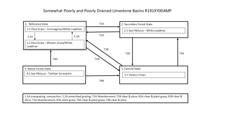
Click on box and path labels to scroll to the respective text.
| T1A | - | The Reference State (1) transitions to the Secondary Forest State (2) by removal of grazing and browsing ungulates, allowing colonization by local tree species. |
|---|---|---|
| T1B | - | The Reference State (1) is restored to the Farmed State (3) by cultivating the soil and then planting crops. |
| T2A | - | The Secondary Forest State (2) can be restored to the Reference State (1) by burning or mechanically clearing trees, shrubs, and undesirable forbs. |
| T2B | - | The Secondary Forest State (2) can be restored to the Farmed State (3) by burning or mechanically clearing trees, shrubs, and undesirable forbs and then cultivating the soil and planting crops. |
| T3B | - | The Farmed State (3) may be restored to the Reference State (1) by cessation of cropping activities. Seeding of desired forage species may be needed if they are not present in the local area. |
| T3A | - | If not artificially drained for crops, the Farmed State (3) will transition to the Secondary Forest State (2) by abandonment. |
| T4A | - | The Native Forest State (4) can transition to the Reference to the Reference State (1) by burning or mechanical clearing. |
| T4B | - | The Native Forest State (4) will transition to the Farmed State (3) by burning or mechanical clearing followed by cultivation and planting crops. Artificial drainage is sometimes installed. |
State 1 submodel, plant communities
| 1.1A | - | Overuse by ungulates results in soil compaction and reduction in competitiveness of dominant, desired forage species that brings a phase change from 1.1 to 1.2 typified by a partial shift to plant species that are less impacted by grazing and browsing. |
|---|---|---|
| 1.2A | - | Community phase 1.2 will revert to phase 1.1 with grazing management. |