Natural Resources
Conservation Service
Ecological site QX191X01X005
Very Poorly Drained Muck
Last updated: 6/12/2025
Accessed: 10/19/2025
General information
Provisional. A provisional ecological site description has undergone quality control and quality assurance review. It contains a working state and transition model and enough information to identify the ecological site.
MLRA notes
Major Land Resource Area (MLRA): 191X–High Limestone Plateaus of the Mariana Islands
This MLRA consists of the northern half of Guam and the islands of Saipan), Tinian, Rota, and Aguijan. Topography consists mostly of limestone plateaus. The highest elevations are 1,700 feet (520 meters) on Rota, 1,485 feet (450 meters) on Saipan, 655 feet (200 meters) on Tinian, and 860 feet (260 meters) in the northern part of Guam. The limestone plateaus were uplifted by tectonic activity. Deeply weathered volcanic rock is exposed on some ridges and slopes. Average annual rainfall is 100 inches (2,540 millimeters) on northern Guam and 80 inches (2,030 millimeters) on Saipan, Tinian, Aguijan, and Rota. The rainy season occurs from July through November; the dry season occurs from December through June. Trade winds blow from the northeast. Average annual temperature is 79 degrees F (26 degrees C). Typhoons are frequent. Soils are Alfisols, Andisols, Entisols, Mollisols, or Oxisols. The dominant soil moisture regime is ustic. The soil temperature regime is isohyperthermic. Native vegetation consists of mixed tropical hardwoods; introduced white leadtree or tangantangan trees (Leucaena leucocephala) are abundant. Introduced deer, pigs, goats, and water buffalo are common (USDA-NRCS, 2006). The main human disturbance is clearing land for cultivation. Feral pigs, feral cattle, brown tree snakes, stray dogs (Boonie dogs), and introduced deer are destructive to the native forest (Amand, 2000; CNMI SWARS Council, 2010; Donnegan et al., 2011; Liske-Clark, 2015; Willsey et al., 2019).
Classification relationships
This ecological site occurs within Major Land Resource Area (MLRA) 191 – High Limestone Plateaus of the Mariana Islands.
Ecological site concept
This ecological site occurs on the islands of Saipan and Tinian in the Mariana Islands. It occurs in nearly level (0 to 2 percent slopes) depressions at elevations ranging from 0 to 16 feet (0 to 5 meters) (Amidon et al., 2017; Liu and Fischer, 2008; USDA-SCS, 1989).
Soils are very deep, very poorly drained Histisols (Terric Haplosaprists) that are formed in marine deposits, alluvium, and organic material. Soil temperature regimes are isohyperthermic; soil moisture regimes are aquic. Average annual rainfall is about 74 inches (1,880 millimeters) (PRISM, 2006). Water runoff is negligible; permeability is moderate. Effective rooting depth is greater than 72 inches (180 centimeters). Available water-holding capacity is about 7 inches (18 centimeters). The surface soil (8 inches or 20 cm deep) is muck; beneath this is mucky clay loam; below this is gravelly sandy loam. Groundwater varies from fresh to saline (EC 8 to 16 dS/m) depending on location. The permanent water table is at ground level most of the year. Flooding is frequent and very brief. Ponding is rare and very brief (USDA-SCS, 1989). Most of the area is vegetated by marsh grasses and, in a few locations, small stands of hibiscus (Hibiscus tiliaceus) or mangrove (Rhizophora spp.) forest. Much of this ecological site occurs around Lake Susupe on Saipan (Fosberg, 1960; USDA-SCS, 1989).
Associated sites
| QX191X01X503 |
Very Shallow to Moderately Deep Soils on Limestone Plateaus Soils of QX191X01X503 (The Very Shallow to Moderately Deep Soils on Limestone Plateaus Ecological Site) formed in fine materials over porous coralline or argillaceous limestone. Effective rooting depth is 8 to 26 inches, available water holding capacity is very low to low (2 to 3 inches), base saturation is high, pH is high (6.5 to 7.9), and there is no aluminum toxicity. Areas not farmed are vegetated by mostly introduced grass, forb, and tree species, with some areas of native upland forest. White leadtree or tangantangan (Leucaena leucocephala) is abundant in places. Soils of QX191X01X005 (The Very Poorly Drained Muck Ecological Site) occurs in depressions near sea level. Soils are very deep (greater than 72 inches) organic soils with fresh to saline groundwater that is at the soil surface. Flooding is frequent; ponding is rare. Most of the area is vegetated by marsh grasses and, in a few locations, small stands of hibiscus (Hibiscus tiliaceus) or mangrove (Rhizophora spp.) forest. |
|---|---|
| QX191X01X501 |
Excessively and Somewhat Excessively Drained Coastal Strand Soils of QX191X01X501 (The Excessively Drained Coastal Strand Ecological Site) formed in coral sand near the sea and fine materials over limestone where it borders inland limestone plateaus and escarpments. Effective rooting depth is 6 to greater than 72 inches; available water holding capacity is very low to low (0 to 3 inches). Windborne salt spray and rare flooding by seawater affect the entire area. Vegetation is mostly native forest. Soils of QX191X01X005 (The Very Poorly Drained Muck Ecological Site) occurs in depressions near sea level. Soils are very deep (greater than 72 inches) organic soils with fresh to saline groundwater that is at the soil surface. Flooding is frequent; ponding is rare. Most of the area is vegetated by marsh grasses and, in a few locations, small stands of hibiscus (Hibiscus tiliaceus) or mangrove (Rhizophora spp.) forest. |
| QX191X01X502 |
Deep and Very Deep Soils on Limestone Plateaus Soils of F191XY502MP (Deep and Very Deep Soils on Limestone Plateaus) formed in fine materials over porous coralline or argillaceous limestone. Effective rooting depth is 47 to 72 inches or deeper and available water holding capacity is low (4 to 5 inches). Most of this ecological site is used for farmland; areas not farmed are vegetated by mostly introduced grass, forb, and tree species. White leadtree or tangantangan (Leucaena leucocephala) is abundant in places. Soils of QX191X01X005 (The Very Poorly Drained Muck Ecological Site) occurs in depressions near sea level. Soils are very deep (greater than 72 inches) organic soils with fresh to saline groundwater that is at the soil surface. Flooding is frequent; ponding is rare. Most of the area is vegetated by marsh grasses and, in a few locations, small stands of hibiscus (Hibiscus tiliaceus) or mangrove (Rhizophora spp.) forest. |
| QX191X01X002 |
Moderately Deep Alfic Soils on Volcanic Uplands Soils of QX191X01X002 (The Moderately Deep Alfic Soils on Volcanic Uplands Ecological Site) formed in residuum derived from andesitic marine tuff and tuffaceous breccia. They are highly weathered Alfisols that have fairly high base saturation, moderately deep effective rooting depths (about 32 inches), surface pH ranging from 6.2 to 6.5, and low available water holding capacity (5 inches). Most of the area is vegetated by grasses, forbs, and mixed forest of introduced and native species. Swordgrass (Miscanthus floridulus) is present in some areas. White leadtree or tangantangan (Leucaena leucocephala) is not abundant. Soils of QX191X01X005 (The Very Poorly Drained Muck Ecological Site) occurs in depressions near sea level. Soils are very deep (greater than 72 inches) organic soils with fresh to saline groundwater that is at the soil surface. Flooding is frequent; ponding is rare. Most of the area is vegetated by marsh grasses and, in a few locations, small stands of hibiscus (Hibiscus tiliaceus) or mangrove (Rhizophora spp.) forest. |
Similar sites
| QX191X01X507 |
Very Poorly Drained Mucky Clay Soils of QX191X01X507 (The Very Poorly Drained Mucky Clay Ecological Site) occur on coastal valley bottoms and plains. Soils formed in alluvium from mixed sources. The surface soil (2 inches deep) is mucky clay; beneath this is clay. Soils have water tables that fluctuate between 0 to 18 inches, have slightly to moderately saline ground water (2 to 8 mmhos/centimeters), and frequent flooding. Most of the area is vegetated by wetland grasses and sedges and, in some locations, mangrove (Rhizophora spp.) forest. Soils of QX191X01X005 (The Very Poorly Drained Muck Ecological Site) occurs in depressions near sea level. Soils are very deep (greater than 72 inches) organic soils with fresh to saline groundwater that is at the soil surface. Flooding is frequent; ponding is rare. Most of the area is vegetated by marsh grasses and, in a few locations, small stands of hibiscus (Hibiscus tiliaceus) or mangrove (Rhizophora spp.) forest. |
|---|
Table 1. Dominant plant species
| Tree |
(1) Hibiscus tiliaceus |
|---|---|
| Shrub |
Not specified |
| Herbaceous |
(1) Phragmites karka |
Legacy ID
R191XY005MP
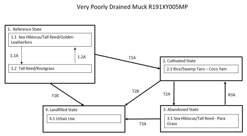
Click on box and path labels to scroll to the respective text.
| T1A | - | The Reference State (1) transitions to the Cultivated State (2) through the removal of native vegetation and planting rice (Oryza sativa), swamp taro (Cyrtosperma chamissonia), or coco yam (Colocasia esculenta). |
|---|---|---|
| T1B | - | The Reference State (1) transitions to the Landfilled State (4) by intentional filling of a marsh to create construction sites. |
| T2A | - | The Cultivated State (2) transitions to the Abandoned State (3) with the abandonment of agricultural fields, which are quickly invaded by native or introduced species. |
| T2B | - | The Cultivated State (2) transitions to the Landfilled State (4) by intentional filling of cropland to create construction sites. |
| R3A | - | The Abandoned State (3) can be restored the Cultivated State (2) by weed removal and resumption of crop cultivation. |
| T3A | - | The Abandoned State (3) transitions to the Landfilled State (4) by intentional filling to create construction sites. |
State 1 submodel, plant communities
| 1.1A | - | Community phase 1.1 changes to phase 1.2 due to damage to native vegetation stands by storms. |
|---|---|---|
| 1.2A | - | Community phase 1.2 may revert to phase 1.1 with gradual regrowth of dominant native species when given adequate time to recover after disturbance. However, it is likely that some introduced species will remain. |