Natural Resources
Conservation Service
Ecological site QX191X01X506
Somewhat Poorly and Poorly Drained Valley Bottoms and Coastal Plains
Last updated: 6/12/2025
Accessed: 10/19/2025
General information
Provisional. A provisional ecological site description has undergone quality control and quality assurance review. It contains a working state and transition model and enough information to identify the ecological site.
MLRA notes
Major Land Resource Area (MLRA): 191X–High Limestone Plateaus of the Mariana Islands
This MLRA consists of the northern half of Guam and the islands of Saipan), Tinian, Rota, and Aguijan. Topography consists mostly of limestone plateaus. The highest elevations are 1,700 feet (520 meters) on Rota, 1,485 feet (450 meters) on Saipan, 655 feet (200 meters) on Tinian, and 860 feet (260 meters) in the northern part of Guam. The limestone plateaus were uplifted by tectonic activity. Deeply weathered volcanic rock is exposed on some ridges and slopes. Average annual rainfall is 100 inches (2,540 millimeters) on northern Guam and 80 inches (2,030 millimeters) on Saipan, Tinian, Aguijan, and Rota. The rainy season occurs from July through November; the dry season occurs from December through June. Trade winds blow from the northeast. Average annual temperature is 79 degrees F (26 degrees C). Typhoons are frequent. Soils are Alfisols, Andisols, Entisols, Mollisols, or Oxisols. The dominant soil moisture regime is ustic. The soil temperature regime is isohyperthermic. Native vegetation consists of mixed tropical hardwoods; introduced white leadtree or tangantangan trees (Leucaena leucocephala) are abundant. Introduced deer, pigs, goats, and water buffalo are common (USDA-NRCS, 2006). The main human disturbance is clearing land for cultivation. Feral pigs, feral cattle, brown tree snakes, stray dogs (Boonie dogs), and introduced deer are destructive to the native forest (Amand, 2000; CNMI SWARS Council, 2010; Donnegan et al., 2011; Liske-Clark, 2015; Willsey et al., 2019).
Classification relationships
This ecological site occurs within Major Land Resource Area (MLRA) 191 – High Limestone Plateaus of the Mariana Islands.
Ecological site concept
This ecological site occurs on the island of Guam in the Marianas Islands. It occurs on nearly level to gently sloping (0 to 4 percent slopes), wide river valley bottoms and long, narrow coastal plains at elevations ranging from 0 to 330 feet (0 to 100 meters) (USDA-SCS, 1988).
Soils are very deep (greater than 72 inches), somewhat poorly and poorly drained Entisols that formed in alluvium derived from volcanic and limestone uplands. On the coast, alluvium is derived from beach deposits. Soil temperature regimes are isohyperthermic; soil moisture regimes are aquic. Average annual precipitation is about 97 inches (2,465 millimeters) and ranges from 92 to 103 inches (2,335 to 2,615 millimeters) (PRISM, 2006). Water runoff is medium; permeability is slow. Effective rooting depth is greater than 72 inches (185 centimeters). Available water-holding capacity is moderate (5 to 6 inches). The water table fluctuates seasonally between about 20 and 40 inches (50 and 100 cm). Flooding is occasional and brief in the rainy season (USDA-SCS, 1988). Most of the area is vegetated by grasses, forbs, and wetland forest (Amidon et al., 2017; Fosberg, 1960; Marshall et al., 2020; Stemmermann, 1981; Stone, 1970; Wagner and Grether, 1948; Willsey et al., 2019).
Associated sites
| QX192X01X501 |
Somewhat Poorly Drained Alluvium Soils of QX192X01X501 (The Somewhat Poorly Drained Alluvium Ecological Site) consists of streams and seeps at higher elevations that feed into QX191X01X506 (The Somewhat Poorly Drained Valleys and Alluvial Plains Ecological Site). Soils, drainage, water tables, and flooding regimes in both ecological sites are similar, except that ground water in coastal areas of QX191X01X506 (The Somewhat Poorly and Poorly Drained Valleys and Alluvial Coastal Plains Ecological Site) are slightly saline rather than fresh. Both ecological sites support wetland forest, grasses, and sedges. |
|---|---|
| QX191X01X503 |
Very Shallow to Moderately Deep Soils on Limestone Plateaus Soils of QX19101X503 (The Very Shallow to Moderately Deep Soils on Limestone Plateaus) formed in fine materials over porous coralline or argillaceous limestone. They are well drained, have ustic moisture regimes, very deep water tables, only fresh groundwater, and no flooding. Areas not farmed are vegetated by mostly introduced grass, forb, and tree species, with some areas of native upland forest. |
| QX192X01X001 |
Moderately Deep Oxic Soils on Volcanic Uplands Soils of QX192X01X001 (The Moderately Deep Oxic Soils on Volcanic Uplands Ecological Site) formed in volcanic materials, are well drained, and have effective rooting depths between 16 and 45 inches, low to moderate (2 to 7 inches) available water holding capacity, low base saturation, low pH (4.5 to 6.0), and aluminum toxicity. Most of the area is vegetated by Pacific silver grass or swordgrass (Miscanthus floridulus). QX191X01X506 (The Somewhat Poorly and Poorly Drained Valleys and Alluvial Coastal Plains Ecological Site) occurs in broad river valley bottoms and narrow coastal plains. Soils formed in alluvium or beach deposits, are somewhat poorly and poorly drained, have aquic moisture regimes, moderately deep water tables, areas of slightly saline groundwater, and are occasionally flooded. Most of the area is vegetated by grasses, forbs, and wetland forest. |
| QX192X01X002 |
Deep Alfic Soils on Volcanic Uplands Soils of QX191X01X002 (The Moderately Deep Alfic Soils on Volcanic Uplands Ecological Site) formed in volcanic materials, are well drained, and have effective rooting depths of 20 to 40 inches, low (4 inches) available water holding capacity, fairly high base saturation, pH ranging from 5.1 to 6.5, and no aluminum toxicity. Most of the area is vegetated by upland forest, grasses, and forbs. QX191X01X506 (The Somewhat Poorly and Poorly Drained Valleys and Alluvial Coastal Plains Ecological Site) occurs in broad river valley bottoms and narrow coastal plains. Soils formed in alluvium or beach deposits, are somewhat poorly and poorly drained, have aquic moisture regimes, moderately deep water tables, areas of slightly saline groundwater, and are occasionally flooded. Most of the area is vegetated by grasses, forbs, and wetland forest. |
| QX191X01X505 |
Very Low Available Water Capacity Soils on Limestone Plateaus and Escarpments Soils of Q191X01X505 (The Very Low Available Water Capacity Soils on Limestone Plateaus and Escarpments Ecological Site) formed in fine materials over porous coralline limestone. They are well drained. Effective rooting depth is 2 to 16 inches; available water holding capacity is very low (1 inches). Most of the area is vegetated by native forest. This ecological site is limited to an area that is often shrouded in clouds and fog. Moisture is added to the soil by fog drip, which maintains soils in moist condition most of the time. It is mostly forested with native species. QX191X01X506 (The Somewhat Poorly and Poorly Drained Valleys and Alluvial Coastal Plains Ecological Site) occurs in broad river valley bottoms and narrow coastal plains. Soils formed in alluvium or beach deposits, are somewhat poorly and poorly drained, have aquic moisture regimes, moderately deep water tables, areas of slightly saline groundwater, and are occasionally flooded. Most of the area is vegetated by grasses, forbs, and wetland forest. |
| QX191X01X507 |
Very Poorly Drained Mucky Clay Soils of QX191X01X507 (The Very Poorly Drained Mucky Clay Ecological Site) occur on coastal valley bottoms and plains. Soils formed in alluvium from mixed sources, are very poorly drained, have aquic moisture regimes, water tables that are at the soil surface to 18 inches (45 centimeters) below the soil surface, slightly to moderately saline ground water, and frequent flooding. Most of the area is vegetated by wetland grasses and sedges and, in some locations, mangrove forest. Soils of QX191X01X506 (The Somewhat Poorly and Poorly Drained Valleys and Alluvial Coastal Plains Ecological Site) occur in broad river valley bottoms and narrow coastal plains. Soils formed in alluvium or beach deposits, are somewhat poorly and poorly drained, have aquic moisture regimes, moderately deep water tables, fresh groundwater except in areas near the coast that have slightly saline groundwater, occasional flooded. Most of the area is vegetated by grasses, forbs, and wetland forest. |
| QX191X01X501 |
Excessively and Somewhat Excessively Drained Coastal Strand Soils of QX191X01X501 (The Excessively and Somewhat Excessively Drained Coastal Strand Ecological Site) formed in coral sand near the sea and fine materials over limestone where it borders inland limestone plateaus and escarpments. Soil drainage is somewhat excessive to excessive. Effective rooting depth is 4 to 63 inches or greater; available water holding capacity is very low to low (0 to 3 inches). Windborne salt spray and rare flooding by seawater affect the entire area. It is mostly forested. Soils of QX191X01X506 (The Somewhat Poorly and Poorly Drained Valleys and Alluvial Coastal Plains Ecological Site) occur in broad river valley bottoms and narrow coastal plains. Soils formed in alluvium or beach deposits, are somewhat poorly and poorly drained, have aquic moisture regimes, moderately deep water tables, fresh groundwater except in areas near the coast that have slightly saline groundwater, occasionally flooded. Most of the area is vegetated by grasses, forbs, and wetland forest. |
| QX192X01X003 |
Shallow Soils on Volcanic Uplands Soils of QX192X01X003 (The Shallow Soils on Volcanic Uplands Ecological Site) formed in volcanic materials in uplands, are well drained, have effective rooting depths of about 15 inches or less, and have very low (2 inches) available water holding capacity. Most of the area is vegetated by grasses, forbs, and forest. Soils of QX191X01X506 (The Somewhat Poorly and Poorly Drained Valleys and Alluvial Coastal Plains Ecological Site) occur in broad river valley bottoms and narrow coastal plains. Soils formed in alluvium or beach deposits, are somewhat poorly and poorly drained, have aquic moisture regimes, moderately deep water tables, fresh groundwater except in areas near the coast that have slightly saline groundwater, occasional flooded. Most of the area is vegetated by grasses, forbs, and wetland forest. |
| QX192X01X004 |
Very Deep Soils on Volcanic Uplands Soils of QX192X01X004 (The Very Deep Soils on Volcanic Uplands Ecological Site) are very deep, well drained Alfisols on the lower slopes, concave areas, and drainageways of volcanic uplands, have low (4 inches) available water holding capacity (but relatively high for soils on volcanic uplands), moderate base saturation, gentle to moderate slopes (3 to 15 percent), no aluminum toxicity, and support a variety of grasses and forbs. Soils of QX191X01X506 (The Somewhat Poorly and Poorly Drained Valleys and Alluvial Coastal Plains Ecological Site) occurs in broad river valley bottoms and narrow coastal plains. Soils formed in alluvium or beach deposits, are somewhat poorly and poorly drained, have aquic moisture regimes, moderately deep water tables, fresh groundwater except in areas near the coast that have slightly saline groundwater, occasional flooded. Most of the area is vegetated by grasses, forbs, and wetland forest. |
Table 1. Dominant plant species
| Tree |
(1) Barringtonia racemosa |
|---|---|
| Shrub |
Not specified |
| Herbaceous |
Not specified |
Legacy ID
F191XY506MP
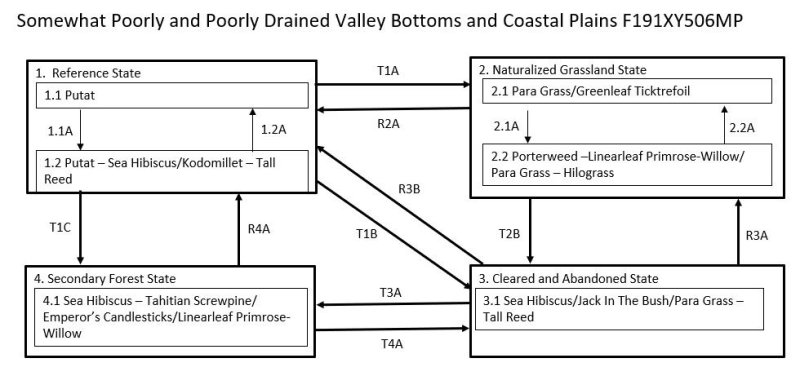
Click on box and path labels to scroll to the respective text.
Ecosystem states
| T1A | - | The Reference State (1) transitions to the Naturalized Grassland State (2) by removal of native vegetation and planting, or allowing colonization by, introduced grass species. |
|---|---|---|
| T1B | - | The Reference State (1) transitions to the Cleared and Abandoned State (3) if previously cleared of forest and then abandoned. This allows heliophytes, both native and introduced, to temporarily cover the ground. |
| T1C | - | The Reference State (1) transitions to the Invaded Forest State (4) by wind damage to the forest when there is a nearby source of seeds of invasive species or, more gradually, by damage to the forest understory by ungulates, especially feral pigs, when there is a source of seeds of invasive species. |
| R2A | - | The Naturalized Grassland State (2) could theoretically be restored to the Reference State (1) by suppression of grassland vegetation and replanting with native species. Natural reseeding by native forest species can be expected if there is a nearby stand of suitable species. |
| T2B | - | The Naturalized Grassland State (2) transitions to the Cleared and Abandoned State (3) upon abandonment of grasslands, which are invaded by low-statured, native and/or introduced heliophytes. |
| R3B | - | The Cleared and Abandoned State (3) may be restored to the Reference State (1). The intensity of active restoration measures will be determined by the presence or lack of nearby native forest or, at least, some native trees as well as the density and species mix of grasses, vines, shrubs, and invasive trees present on the site, especially if many competitive introduced species are present. |
| R3A | - | The Cleared and Abandoned State (3) may be restored to the Naturalized Grassland State (2) by land clearing, weed control, and replanting grasses. |
| T3A | - | The Cleared and Abandoned State (3) transitions to the Invaded Forest State (4) by growth of an overstory of trees with an understory of shade-tolerant shrubs, vines, ferns, forbs, and grasses. The species mix is variable but may be mostly introduced species or a combination of native and introduced species. |
| R4A | - | The Invaded Forest State (4) can be restored to the Reference State (1). The difficulty, cost, and likelihood of success will depend on the species composition and amount and competitiveness of introduced species present on a given site. |
| T4A | - | The Invaded Forest State (4) may transition to Cleared and Abandoned State (3) due to mechanical clearing or fire. State 3 is likely to rapidly transition back to State 4 due to the presence of an abundant tree seed bank in the soil. |
State 1 submodel, plant communities
| 1.1A | - | Storms that damage or kill putat (Barringtonia racemosa) trees cause a phase change from 1.1 to 1.2 typified by a partial, temporary change in dominant tree species and a temporary invasion by ground level vegetation. |
|---|---|---|
| 1.2A | - | Community phase 1.2 will revert to phase 1.1 with dominance by putat (Barringtonia racemosa) when given adequate time to recover after disturbance. |
State 2 submodel, plant communities
| 2.1A | - | Community phase 2.1 will change to 2.2 by invasion of the site by shrubs and forbs. This process is facilitated by excessive grazing, which reduces the competitive advantage of para grass (Urochloa mutica). |
|---|---|---|
| 2.2A | - | Community phase 2.2 can shift back to phase 2.1 by reducing grazing pressure on paragrass (Urochloa mutica) and, when necessary, performing spot weed control on shrubs and forbs. |