Natural Resources
Conservation Service
Ecological site QX190X01X001
Very Shallow
Last updated: 6/12/2025
Accessed: 10/20/2025
General information
Provisional. A provisional ecological site description has undergone quality control and quality assurance review. It contains a working state and transition model and enough information to identify the ecological site.
MLRA notes
Major Land Resource Area (MLRA): 190X–Stratovolcanoes of the Mariana Islands
This MLRA occurs on the Northern Islands group of the Commonwealth of the Northern Mariana Islands. It consists of the islands of Pagan, Anatahan, Agrigan, Alamagan, Sarigan, and five smaller islands. The islands are largely unpopulated due to volcanic activity. The islands are cone-shaped stratovolcanoes covered with volcanic ash and cinder deposits on steep and very steep slopes. Agrigan has the highest elevation, ranging from sea level to 3,185 feet (970 meters). Average annual precipitation is about 80 inches (2,030 millimeters). Rainfall decreases northwards and increases slightly with elevation. Two-thirds of the precipitation falls between July and November. Average annual temperature is 79 degrees F (26 degrees C). The cooler dry season is between January and May. Trade winds blow from the northeast and east-northeast. Typhoons are frequent. Soils are Andisols, Inceptisols, or Entisols. The soil moisture regime is mostly ustic. The soil temperature regime is isohyperthermic. Abandoned coconut plantations occur on low elevation coastal sites. Areas above 330 feet (100 meters) are dominated by Pacific Island silvergrass or swordgrass (Miscanthus floridulus). Forest species are mixed tropical hardwoods. Large numbers of feral cows, pigs, and goats are on some of the islands (USDA-Natural Resources Conservation Service, 2006).
Classification relationships
This ecological site occurs within Major Land Resource Area (MLRA) 190 – Stratovolcanoes of the Mariana Islands.
Ecological site concept
This ecological site occurs on the islands of Agrigan, Alamagan, Anatahan, and Sarigan in the Mariana Islands. It occurs on moderately sloping to very steep (8 to 125 percent) slopes on the crests of ridges on the dissected backslopes and footslopes of stratovolcanic islands at elevations ranging from 164 to 2,430 feet (50 to 740 meters) (Soil Survey Staff, 2025; Amidon et al., 2017; Amidon et al., 2019; Carlisle et al., 2001; Fosberg, 1960; Kessler, 2011; Liske-Clark, 2105; USDA-Natural Resources Conservation Service, 2001; Willsey et al., 2019).
Soils are very shallow (1 to 8 inches or 3 to 20 centimeters), well drained Andisols (Lithic Haplustands) that formed in basaltic and andesitic volcanic ash and cinders. Soil temperature regimes are isohyperthermic; soil moisture regimes are ustic. Average annual precipitation is about 80 inches (2,030 millimeters). Water runoff is high or very high; permeability is very slow (impermeable). Effective rooting depth is about 5 inches (13 cm). Available water holding capacity is very low (0 to 1 inches). The soils are strongly acidic (pH 5 to 6.6). Native and naturalized vegetation includes Pacific Island silvergrass or swordgrass (Miscanthus floridulus) and assorted short grasses (Soil Survey Staff, 2025; Amidon et al., 2017; Amidon et al., 2019; Carlisle et al., 2001; Fosberg, 1960; Kessler, 2011; Liske-Clark, 2105; USDA-Natural Resources Conservation Service, 2001; Willsey et al., 2019).
A large portion of the land area of these islands is mapped by the Soil Survey as either Miscellaneous Land Types or are classified only to the Great Group level. These map units are not used in ecological site work. The components of most of these map units are very steep (typically 45 to 150 percent slopes). The Miscellaneous Land Types are mostly Cinderlands, Lava flows, Rubble land, or Rock outcrops. The Great Group soil components are mostly complexed with Rock outcrops. Vegetation can be sparse to nonexistent on these areas (USDA-Natural Resources Conservation Service, 2001). However, some of them probably support vegetation like that found in this ecological site.
Associated sites
| QX190X01X501 |
Aquic Soils of QX190X01X501 (The Somewhat Poorly and Poorly Drained Limestone Basins Ecological Site) occur in depressional basins surrounded by the slopes of QX190X01X001 (The Very Shallow Ecological Site). Water will move from the Very Shallow Ecological Site into the Somewhat Poorly and Poorly Drained Limestone Basins Ecological Site. Soils in both sites developed from basaltic and andesitic ash. Soils in the Very Shallow Ecological Site have effective rooting depths of about 5 inches, very low available water holding capacity, and support mostly Pacific Island silvergrass (swordgrass). Soils in the Somewhat Poorly and Poorly Drained Limestone Basins Ecological Site have effective rooting depths of about 60 inches, very high water holding capacity, a water table at the soil surface, are frequently ponded, can support trees and crops, and may be swampy during the rainy season. |
|---|---|
| QX190X01X504 |
Silt Loam Soils of QX190X01X504 (The Silt Loam Ecological Site) and QX190X01X001 (The Very Shallow Ecological Site) occur on similar landscapes, soil parent materials, and slopes. The Silt Loam Ecological Site generally occurs at lower elevations than the Very Shallow Ecological Site. The main differences between the two sites are that soils in the Silt Loam Ecological Site have much deeper effective rooting depths, shallower water tables, and higher available water holding capacity than soils in the Very Shallow Ecological Site. This enables the Silt Loam Ecological Site to support forest vegetation rather than just the Pacific Island silvergrass (swordgrass) and other grasses that dominate the vegetation of the Very Shallow Ecological Site. |
| QX190X01X503 |
Sandy Loam or Loam Soils of QX190X01X503 (The Sandy Loam or Loam Ecological Site) and QX190X01X001 (The Very Shallow Ecological Site) ecological site occur on similar landscapes, soil parent materials, and slopes. The Sandy Loam or Loam Ecological Site generally occurs at lower elevations than the Very Shallow Ecological Site. The main differences between the two sites are that soils in the Sandy Loam or Loam Ecological Site have deeper effective rooting depths and higher available water holding capacity than soils in the Very Shallow Ecological Site. This enables the Sandy Loam or Loam Ecological Site to support forest vegetation and grasses rather than just the Pacific Island silvergrass (swordgrass) and other grasses that dominate the vegetation of the Very Shallow Ecological Site. |
Table 1. Dominant plant species
| Tree |
Not specified |
|---|---|
| Shrub |
Not specified |
| Herbaceous |
(1) Miscanthus floridulus |
Legacy ID
R190XY001MP
Click on box and path labels to scroll to the respective text.
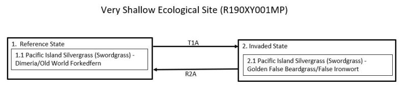
Ecosystem states
| T1A | - | The Reference transitions (1) transitions to the Invaded State (2) by gradual invasion by introduced plant species. This process is facilitated by large populations of feral ungulates that selectively graze the smaller and more palatable native grass species, which reduces their competitiveness and allows invasion by introduced species. |
|---|---|---|
| R2A | - | The Invaded State (2) is restored to the Reference State (1) by removal of ungulates and selective elimination of introduced species. |