Natural Resources
Conservation Service
Ecological site QX190X01X501
Aquic
Last updated: 6/12/2025
Accessed: 10/19/2025
General information
Provisional. A provisional ecological site description has undergone quality control and quality assurance review. It contains a working state and transition model and enough information to identify the ecological site.
MLRA notes
Major Land Resource Area (MLRA): 190X–Stratovolcanoes of the Mariana Islands
This MLRA occurs on the Northern Islands group of the Commonwealth of the Northern Mariana Islands. It consists of the islands of Pagan, Anatahan, Agrigan, Alamagan, Sarigan, and five smaller islands. The islands are largely unpopulated due to volcanic activity. The islands are cone-shaped stratovolcanoes covered with volcanic ash and cinder deposits on steep and very steep slopes. Agrigan has the highest elevation, ranging from sea level to 3,185 feet (970 meters). Average annual precipitation is about 80 inches (2,030 millimeters). Rainfall decreases northwards and increases slightly with elevation. Two-thirds of the precipitation falls between July and November. Average annual temperature is 79 degrees F (26 degrees C). The cooler dry season is between January and May. Trade winds blow from the northeast and east-northeast. Typhoons are frequent. Soils are Andisols, Inceptisols, or Entisols. The soil moisture regime is mostly ustic. The soil temperature regime is isohyperthermic. Abandoned coconut plantations occur on low elevation coastal sites. Areas above 330 feet (100 meters) are dominated by Pacific Island silvergrass or swordgrass (Miscanthus floridulus). Forest species are mixed tropical hardwoods. Large numbers of feral cows, pigs, and goats are on some of the islands (USDA-NRCS, 2006).
Classification relationships
This ecological site occurs within Major Land Resource Area (MLRA) 190 – Stratovolcanoes of the Mariana Islands.
Ecological site concept
This ecological site occurs on the island of Anatahan in the Mariana Islands. It occurs on nearly level to gently sloping (0 to 8 percent slopes) sites in broad depressional basins of stratovolcanic islands at elevations ranging from 190 to 210 feet (60 to 65 meters).
Soils are very deep, somewhat poorly drained Inceptisols (Aquandic Endoaquepts) that formed in basaltic and andesitic volcanic ash. Soil temperature regimes are isohyperthermic; soil moisture regimes are aquic. Average annual precipitation is about 80 inches (2,030 millimeters). Water runoff is low; permeability is slow. Effective rooting depth is greater than 72 inches (183 centimeters). Available water holding capacity is very high (7 to 11 inches). The water table is at the soil surface. Ponding is occasional during the rainy season. Where the land is not used for betelnut plantation or agroforestry crops, the vegetation consists of sea hibiscus (Hibiscus tiliaceus) and grasses (Carlisle et al., 2001; Fosberg, 1960; USDA-Natural Resources Conservation Service, 2001; Soil Survey Staff, 2025).
Associated sites
| QX190X01X001 |
Very Shallow Soils of QX190X01X001 (The Very Shallow Ecological Site) occur on steeper slopes surrounding QX190X01X501 (The Aquic Ecological Site), which is in depressional basins. Water will move from the Very Shallow Ecological Site, which has very slow permeability and high or very high runoff, into the Aquic Ecological Site. Soils in both sites developed from basaltic and andesitic ash. Soils in the Very Shallow Ecological Site have effective rooting depths of about 5 inches, very low available water holding capacity, and support mostly Pacific Island silvergrass (swordgrass). Soils in the Aquic Ecological Site have effective rooting depths of about 60 inches, very high water holding capacity, a water table as shallow at the soil surface, are frequently ponded, can support trees and crops, and may be swampy during the rainy season. |
|---|
Table 1. Dominant plant species
| Tree |
(1) Hibiscus tiliaceus |
|---|---|
| Shrub |
Not specified |
| Herbaceous |
(1) Phragmites karka |
Legacy ID
F190XY501MP
Click on box and path labels to scroll to the respective text.
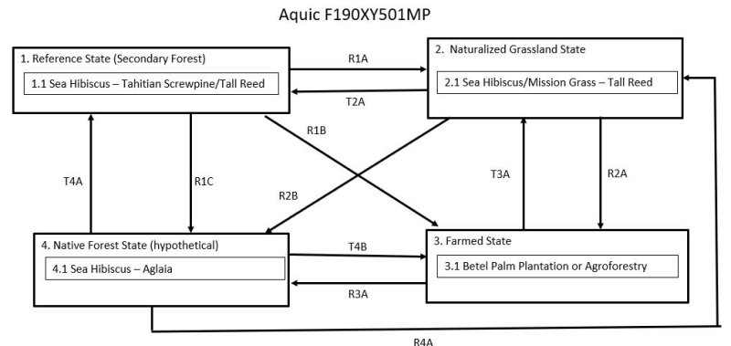
Ecosystem states
| R1A | - | The Reference State (1) can be restored to the Naturalized Grassland State (2) by burning or mechanically clearing trees, shrubs, and undesirable forbs. Heavy use by introduced ungulates may inhibit tree reproduction enough to eventually open up the vegetation and allow for increased open areas dominated by grasses. |
|---|---|---|
| R1B | - | The Reference State (1) can be restored to The Farmed State (3) by burning or mechanically clearing trees, shrubs, and undesirable forbs and then cultivating the soil and planting crops. |
| R1C | - | The Reference State (1) may be restored to The Native Forest State (4) by selectively removing or killing introduced species and replanting native species. Removal of feral ungulates would be necessary. |
| T2A | - | The Naturalized Grassland State (2) transitions to the Reference State (1) by removal of grazing and browsing ungulates, allowing colonization by local tree species. |
| R2A | - | The Naturalized Grassland State (2) transitions to the Farmed State (3) by plowing and then planting crops. |
| R2B | - | The Naturalized Grassland State (2) may be restored to the Native Forest State (4) by removing ungulates, controlling grasses and introduced plant species, and planting native trees and other plants. |
| T3A | - | The Farmed State (3) will transition the Naturalized Grassland State (2) by abandonment. |
| R3A | - | The Farmed State (3) may be restored to the Native Forest State (4) by ceasing agricultural activities, controlling weeds, excluding ungulates, and planting native species. |
| T4A | - | The Native Forest State (4) can transition to the Reference State (1) by partial clearing for agriculture, heavy selective wood removal, and/or extremely heavy soil compaction, browsing, and grazing by introduced ungulates. |
| R4A | - | The Native Forest State (4) may be converted to the Naturalized Grassland State (2) by frequent intentional burning during the dry season, a combination of heavy ungulate damage and occasional intentional burning, or by mechanical clearing and abandonment. |
| T4B | - | The Native Forest State (4) will transition to the Farmed State (3) by burning or mechanical followed by cultivation and planting crops. |