Natural Resources
Conservation Service
Ecological site QX190X01X503
Sandy Loam or Loam
Last updated: 6/12/2025
Accessed: 10/19/2025
General information
Provisional. A provisional ecological site description has undergone quality control and quality assurance review. It contains a working state and transition model and enough information to identify the ecological site.
MLRA notes
Major Land Resource Area (MLRA): 190X–Stratovolcanoes of the Mariana Islands
This MLRA occurs on the Northern Islands group of the Commonwealth of the Northern Mariana Islands. It consists of the islands of Pagan, Anatahan, Agrigan, Alamagan, Sarigan, and five smaller islands. The islands are largely unpopulated due to volcanic activity. The islands are cone-shaped stratovolcanoes covered with volcanic ash and cinder deposits on steep and very steep slopes. Agrigan has the highest elevation, ranging from sea level to 3,185 feet (970 meters). Average annual precipitation is about 80 inches (2,030 millimeters). Rainfall decreases northwards and increases slightly with elevation. Two-thirds of the precipitation falls between July and November. Average annual temperature is 79 degrees F (26 degrees C). The cooler dry season is between January and May. Trade winds blow from the northeast and east-northeast. Typhoons are frequent. Soils are Andisols, Inceptisols, or Entisols. The soil moisture regime is mostly ustic. The soil temperature regime is isohyperthermic. Abandoned coconut plantations occur on low elevation coastal sites. Areas above 330 feet (100 meters) are dominated by Pacific Island silvergrass or swordgrass (Miscanthus floridulus). Forest species are mixed tropical hardwoods. Large numbers of feral cows, pigs, and goats are on some of the islands (USDA-Natural Resources Conservation Service, 2006).
Classification relationships
This ecological site occurs within Major Land Resource Area (MLRA) 190 – Stratovolcanoes of the Mariana Islands.
Ecological site concept
This ecological site occurs on the islands of Agrigan, Alamagan, Pagan, and Sarigan in the Mariana Islands. It occurs on nearly level to very steep (0 to 100 percent) slopes of dissected footslopes, backslopes, alluvial fans, terraces, and lava plains on stratovolcanic islands at elevations ranging from 10 to 1,870 feet (3 to 570 meters) (Amidon et al., 2017; Carlisle et al., 2001; Fosberg, 1960; Kessler, 2011; Liske-Clark, 2015; USDA-Natural Resources Conservation Service, 2001; Willsey et al., 2019; Soil Survey Staff, 2025).
Soils are moderately deep to very deep (21 to 72 inches or 53 to 183 centimeters), well drained Andisols (Typic Ustivitrands and Humic Ustivitrands) that formed in basaltic and andesitic volcanic ash and cinders. Soil temperature regimes are isohyperthermic; soil moisture regimes are ustic. Textures of the soil surface horizon range from ashy fine sandy loam to ashy loam. Average annual rainfall is about 80 inches (2,030 millimeters). Water runoff is low to very high; permeability is moderate or moderately rapid. Available water-holding capacity is moderate for most soils. Native and naturalized vegetation includes trees and short grasses (Amidon et al., 2017; Carlisle et al., 2001; Fosberg, 1960; Kessler, 2011; Liske-Clark, 2015; USDA-Natural Resources Conservation Service, 2001; Willsey et al., 2019; Soil Survey Staff, 2025).
Associated sites
| QX190X01X001 |
Very Shallow Soilis of QX190X01X001 (The Very Shallow Ecological Site) and QX190X01X503 (The Sandy Loam or Loam Ecological Site) occur on similar landscapes, soil parent materials, and slopes. The Sandy Loam or Loam Ecological Site generally occurs at lower elevations than the Very Shallow Ecological Site. The main differences between the two sites are that soils in the Sandy Loam or Loam Ecological Site have deeper effective rooting depths and higher available water holding capacity than soils in the Very Shallow Ecological Site. This enables the Sandy Loam or Loam Ecological Site to support forest vegetation and grasses rather than just the Pacific Island silvergrass (swordgrass) and other grasses that dominate the vegetation of the Very Shallow Ecological Site. |
|---|
Similar sites
| QX190X01X504 |
Silt Loam Soils of QX190X01X504 (The Silt Loam Ecological Site) and QX190X01X503 (The Sand Loam or Loam Ecological Site) occur on similar landscapes, soil parent materials, and at similar elevation ranges. The Silt Loam Ecological soils have finer textures and greater available water holding capacity than the soils of this ecological site. Vegetative productivity should be somewhat higher in the Silt Loam Ecological Site than the Sandy Loam or Loam Ecological Site |
|---|
Table 1. Dominant plant species
| Tree |
(1) Pisonia grandis |
|---|---|
| Shrub |
Not specified |
| Herbaceous |
(1) Asplenium nidus |
Legacy ID
F190XY503MP
Click on box and path labels to scroll to the respective text.
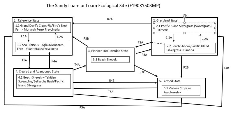
Ecosystem states
States 1, 5 and 2 (additional transitions)
| T1A | - | The Reference State (1) may transition to the Cleared and Abandoned State (4) by mechanical clearing of the land followed by invasion by introduced species and increase of native nondominant species. |
|---|---|---|
| R2A | - | The Grassland State (2) can be restored to a facsimile of the Reference State (1) by suppressing grasses and replanting native trees. Protection from ungulates will likely be needed. |
| T2A | - | The Grassland State (2) will transition to the Pioneer Tree-Invaded State (3) from Community Phase 2.2 as beach sheoak gradually forms denser stands and outcompetes other vegetation. |
| R2B | - | The Grassland State (2) can be restored to the Farmed State (5) by removing grass species and cultivating crops or planting agroforest. |
| R3B | - | The Pioneer Tree-Invaded State (3) can be restored to a facsimile of Reference State (1) by removal of beach sheoak followed by replanting of a variety of native tree species commonly found in State 1. |
| R3A | - | The Pioneer Tree-Invaded State (3) may be restored to the Grassland State (2) by human-caused fire. |
| R3C | - | The Pioneer Tree-Invaded State (3) can be restored to the Farmed State (5) by clearing the land and cultivating crops or planting agroforest. |
| R4A | - | The Cleared and Abandoned State (4) may be restored to a facsimile of the Reference State (1) by brush and weed control followed by replenishing native tree species and numbers. |
| T4B | - | The Cleared and Abandoned State (4) may transition to the Grassland State (2) if fire clears a site before development of closed forest with little understory and where Pacific Island silvergrass is either still present or seed sources are nearby. |
| T4A | - | The Cleared and Abandoned State (4) may transition to the Pioneer Tree-Invaded State (3) by if few or no seed sources for trees other than beach sheoak are near the site during the temporary stage dominated by grasses, forbs, and shrubs. |
| R4B | - | The Cleared and Abandoned State (4) may be restored to the Farmed State (5) by clearing the site, followed by cultivation or planting agroforest. |
| R5A | - | The Farmed State (5) may be restored to a facsimile of the Reference State (1) by weed control followed by replanting of native trees. |
| T5A | - | The Farmed State (5) transitions to the Cleared and Abandoned State (4) when the site is abandoned in the presence of tree seed sources. |
State 1 submodel, plant communities
| 1.1A | - | Community phase 1.1 may shift to phase 1.2 by damage from powerful storms. |
|---|---|---|
| 1.2A | - | Community phase 1.2 reverts to phase 1.1 by regrowth of the original dominant species if given enough time between strong storm events. |
State 2 submodel, plant communities
| 2.1A | - | Community phase 2.1 will shift to Community Phase 2.2 with invasion by native beach sheoak (Casuarina equisetifolia). |
|---|---|---|
| P2.2A | - | Community phase 2.2 will revert to Community Phase 2.1 with human-caused fire, which kills beach sheoak. |