Natural Resources
Conservation Service
Ecological site R055BY070ND
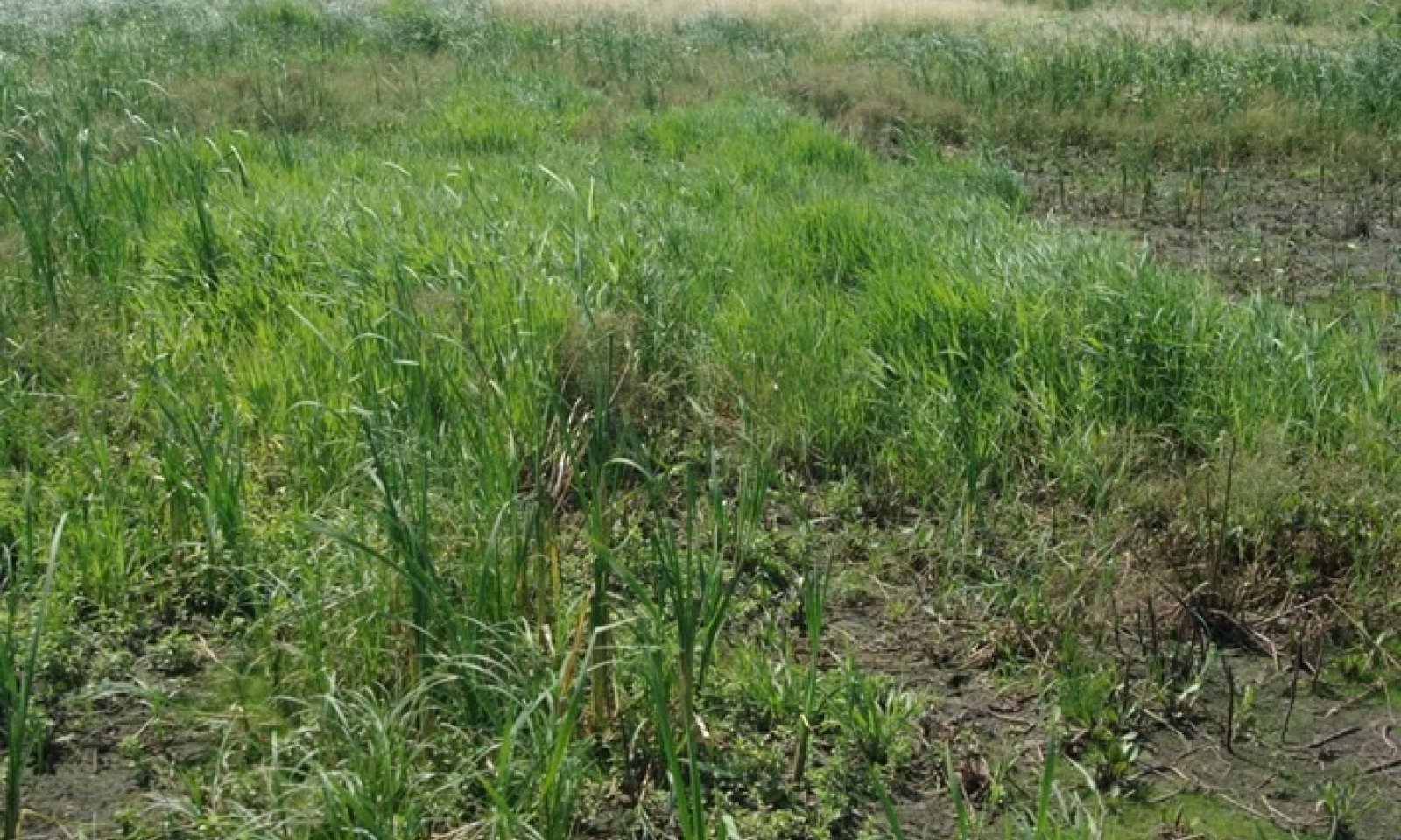
Shallow Marsh
Last updated: 4/25/2025
Accessed: 05/19/2025
General information
Provisional. A provisional ecological site description has undergone quality control and quality assurance review. It contains a working state and transition model and enough information to identify the ecological site.
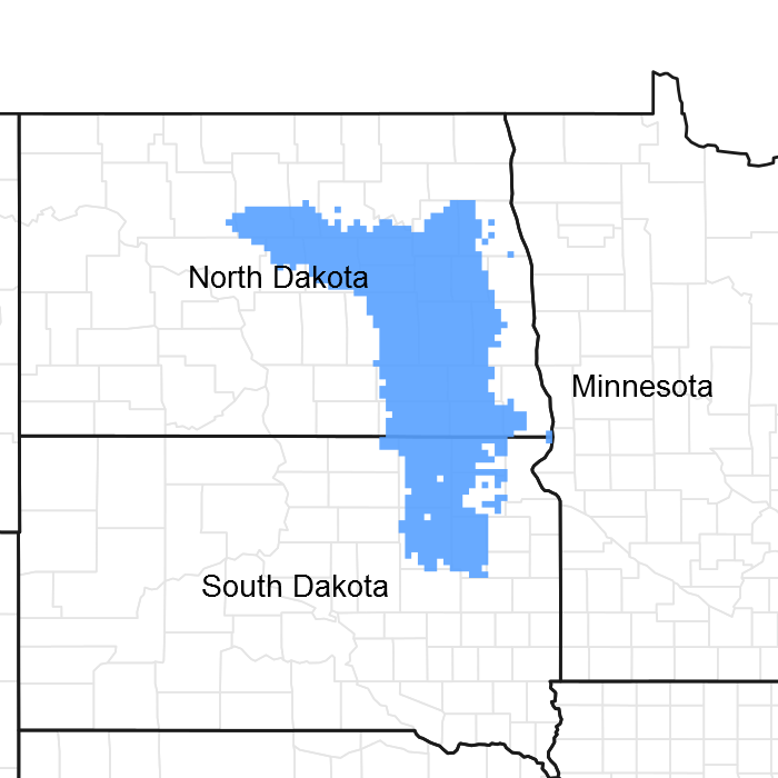
Figure 1. Mapped extent
Areas shown in blue indicate the maximum mapped extent of this ecological site. Other ecological sites likely occur within the highlighted areas. It is also possible for this ecological site to occur outside of highlighted areas if detailed soil survey has not been completed or recently updated.
MLRA notes
Major Land Resource Area (MLRA): 055B–Central Black Glaciated Plains
Central Black Glaciated Plains MLRA is an expansive and agriculturally important region consisting of more than 10,000,000 acres and including all or a portion of 27 counties in east-central and southeastern North Dakota and northeastern South Dakota.
Most of MLRA 55B is covered by till: material that was moved and redeposited by the glaciers. Pre-glaciated bedrock (shale) is exposed on the breaks to some of the valleys and incised drainageways; but what covers the bedrock is glacial sediment, known as drift. These areas have the Late Wisconsin age till plain integrated drainage system in contrast to the closed drainage of much of the till plain and moraines. Some soils, particularly along the Elm, James and Sheyenne rivers, have weathered shale beds in the substratum.
The Drift Prairie Region consists of nearly level to gently rolling glacial till plains dissected by glacial outwash channels. MLRA 55B is located within the boundaries of the Prairie Pothole Region with numerous wetlands in areas without integrated drainage systems. Seven rivers flow through parts of the MLRA. The James and Sheyenne Rivers both have their headwaters in the northern part of the MLRA. A relatively narrow, low range of hills separates these rivers creating a continental watershed divide. The James River flows generally southward through the MLRA and empties into the Missouri River beyond the MLRA border. The Sheyenne River flows to the south and to the east; it empties into the Red River of the North in MLRA 56A. Major tributaries to the James River are the Pipestem and Elm Rivers. The Sheyenne River receives additional water from Devils Lake (during periods of high lake levels) via two outlet pumping stations. Other important rivers in the MLRA are the Goose, Maple, and Wild Rice rivers which are also tributaries to the Red River of the North. The Wild Rice River begins in northeastern South Dakota and flows northward and eastward. In Sargent County, North Dakota, major ditch construction has served to straighten this river and more quickly drain water off adjacent farmland.
Surface and subsurface (tile) drainage systems have been constructed/installed in many areas to manage excess water and/or salinity on cropland. Soils that were poorly drained prior to wide-spread drainage may now function as somewhat poorly drained or moderately well drained soils. Restoration of hydrology to the natural conditions of the reference state may not be possible.
This region is utilized mostly by farms and ranches; about 75 percent is non-irrigated cropland. Cash-grain, bean and oil production crops are the principal enterprise on many farms, but other feed grains and hay are also grown. The vegetation on the steeper slopes, very stony areas, and thinner (or sandy) soils is still native rangeland. About 1 percent of this area is forested. Most forested areas occur along rivers, particularly the Sheyenne River Valley.
Classification relationships
Level IV Ecoregions of the Conterminous United States: 46c – Glacial Lake Basins; 46d – Glacial Lake Delta; 46e – Tewaukon Dead ice Moraine; 46f – End Moraine Complex; 46i – Drift Plains; and 46j – Glacial Outwash
Wetland Description: System Subsystem Class Sub-class Water Regime
Cowardin, et. al., 1979 Palustrine N/A Emergent Persistent Seasonal
Ecological site concept
The Shallow Marsh ecological site is most commonly in deep depressions on till plains, lake plains, outwash plains, and eolian sand plains; but it also occurs in drainageways and depressional areas of flood plains. The soil is very deep. The dark-colored surface soil is more than 7 inches thick and generally more than 20 inches thick; however, some soils with thin topsoil layers (<7 inches) are included. The site is very poorly drained; under normal climatic conditions, it is ponded for very long periods during the growing season. Typically, the depth of ponding is less than 3 feet in the spring and less than 1.5 feet in late summer. Soil salinity (E.C. <16 dS/m) is allowable on this site. Effervescence ranges from none to strong. Hydrology (surface and sub- surface) is the primary factor used in identifying this site. All textures are included in the site. Slope is less than 1 percent. On the landscape, this site is below the Clayey, Loamy, Loamy Overflow, Limy Subirrigated, Subirrigated, Subirrigated Sands, and Wet Meadow ecological sites. The Saline Lowland site is slightly higher on rims of depressions and adjacent flats; it has moderate to very strong soil salinity.
To see a full copy of the ecological site description with all tables and the full version 5 rangeland health worksheet. Please use the following hyperlink:
https://efotg.sc.egov.usda.gov/references/public/ND/55B_Shallow_Marsh_Narrative_FINAL_Ref_FSG.pdf
Associated sites
| R055BY058ND |
Limy Subirrigated This site occurs on flats adjacent to Shallow Marsh sites. All textures are included in this site. They are highly calcareous in the upper part of the subsoil and have redoximorphic features at a depth of 18 to 30 inches. |
|---|---|
| R055BY060ND |
Saline Lowland This site is poorly drained or somewhat poorly drained and occurs on rims of depressions and adjacent flats. It has an accumulation of salts in the surface and subsoil layer (E.C. >8). Typically, this site does not have a claypan layer, but one is allowed if the soil is poorly drained. All textures are included in this site. |
| R055BY065ND |
Subirrigated This site is somewhat poorly drained and occurs on flats adjacent to Shallow Marsh sites. The soils are non-effervescent to a depth >16 inches; redoximorphic features at a depth of 18 to 30 inches. All textures are included in the site. |
| R055BY071ND |
Wet Meadow This site is in shallow depressions and on low-lying flats. It is poorly drained - a seasonal high water table is typically within a depth of 1.5 feet during the months of April through June; in depressions, it is frequently ponded (typically <1.5) in April and May. It typically has redoximorphic features within a depth of 18 inches. Some soils are highly calcareous. It is non-saline to slightly saline (E.C. <8) in the surface and subsoil layers. All textures are included in this site. |
| R055BY056ND |
Clayey This site occurs on nearby uplands. The subsoil layers form a ribbon >2 inches long. It is >30 inches to redoximorphic features. |
| R055BY074ND |
Subirrigated Sands This site occurs on nearby uplands of sandy plains. The upper 20 inches does not form a ribbon. Redoximorphic features occur between 30 and 40 inches. |
| R055BY059ND |
Loamy Overflow This site occurs in upland swales and on floodplains. The surface and subsoil layers form a ribbon 1 to 2 inches long. It is >30 inches to redoximorphic features. |
| R055BY064ND |
Loamy This site occurs on higher, linear slopes on nearby uplands. The surface layer and subsoil layers form a ribbon 1 to 2 inches long. It is >30 inches to redoximorphic features. |
Similar sites
| R055BY071ND |
Wet Meadow This site is in shallow depressions and on low-lying flats. It is poorly drained - a seasonal high water table is typically within a depth of 1.5 feet during the months of April through June; in depressions, it is frequently ponded (typically <1.5) in April and May. It typically has redoximorphic features within a depth of 18 inches. Some soils are highly calcareous. It is non-saline to slightly saline (E.C. <8) in the surface and subsoil layers. All textures are included in this site. |
|---|
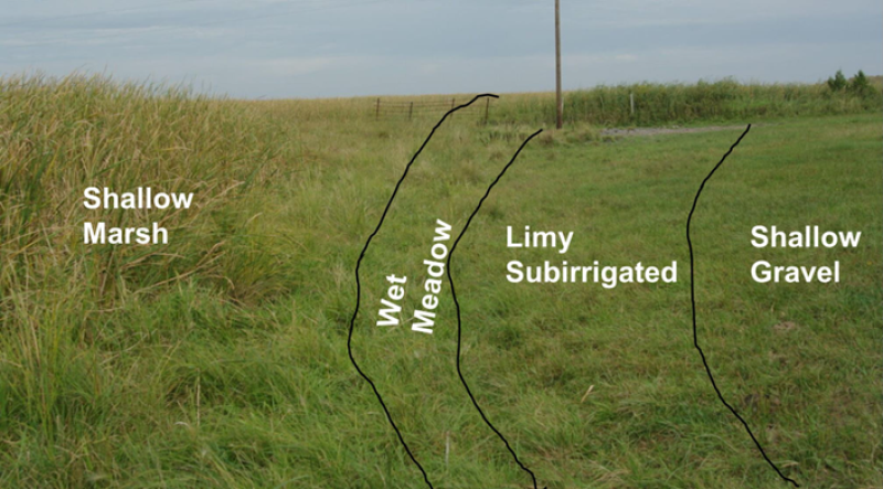
Figure 2. Shallow Marsh ecological site in relationship to other ecological sites.
Table 1. Dominant plant species
| Tree |
Not specified |
|---|---|
| Shrub |
Not specified |
| Herbaceous |
(1) Carex atherodes |
Physiographic features
This site typically occurs in deep depressions on uplands – till plains, lake plains, outwash plains, and eolian sand plains; however, it also occurs in drainageways and on depressional areas of flood plains. Parent materials are alluvium, glaciolacustrine sediments, glaciofluvial deposits, or eolian sands. Slope is less than 1 percent.
Table 2. Representative physiographic features
| Landforms |
(1)
Pothole
(2) Depression (3) Flood plain |
|---|---|
| Runoff class | Very low |
| Flooding duration | Very long (more than 30 days) |
| Flooding frequency | None to frequent |
| Ponding duration | Very long (more than 30 days) |
| Ponding frequency | None to frequent |
| Elevation | 980 – 2,135 ft |
| Slope | 1% |
| Ponding depth | 36 in |
| Water table depth | 18 in |
| Aspect | Aspect is not a significant factor |
Climatic features
MLRA 55B is considered to have a continental climate – cold winters and hot summers, low humidity, light rainfall, and much sunshine. Extremes in temperature are characteristic of the MLRA. The climate is the result of this MLRA’s location in the geographic center of North America. There are few natural barriers on the northern Great Plains. The air masses move unobstructed across the plains and account for rapid changes in temperature.
Annual precipitation ranges from 18 to 23 inches per year. The normal average annual temperature is about 41.5° F. January is the coldest month with average low temperature ranging from about -4.3° F (Petersburg, ND) to about 2.5° F (Mellette, SD). July is the warmest month with temperatures averaging from about 79° F (Petersburg, ND) to about 84° F (Mellette, SD). The range of normal average monthly temperatures between the coldest and warmest months is about 64° F. This large annual range attests to the continental nature of this MLRA's climate. Winds average about 11 miles per hour annually, ranging from about 13 miles per hour during the spring to about 10 miles per hour during the summer. Daytime winds are generally stronger than nighttime and strong storms may bring brief periods of high winds with gusts to more than 50 miles per hour.
Growth of native cool-season plants begins in late March and continues to early to mid-July. Native warm- season plants begin growth in mid-May and continue to the end of August. Greening up of cool-season plants can occur in September and October when adequate soil moisture is present.
Table 3. Representative climatic features
| Frost-free period (characteristic range) | 111-117 days |
|---|---|
| Freeze-free period (characteristic range) | 128-134 days |
| Precipitation total (characteristic range) | 19-22 in |
| Frost-free period (actual range) | 105-119 days |
| Freeze-free period (actual range) | 124-135 days |
| Precipitation total (actual range) | 18-23 in |
| Frost-free period (average) | 114 days |
| Freeze-free period (average) | 131 days |
| Precipitation total (average) | 21 in |
Figure 3. Monthly precipitation range
Figure 4. Monthly minimum temperature range
Figure 5. Monthly maximum temperature range
Figure 6. Monthly average minimum and maximum temperature
Figure 7. Annual precipitation pattern
Figure 8. Annual average temperature pattern
Climate stations used
-
(1) BUTTE 5SE [USC00321225], Butte, ND
-
(2) CARRINGTON [USC00321360], Carrington, ND
-
(3) FORMAN 5 SSE [USC00323117], Forman, ND
-
(4) HARVEY 4NE [USC00324013], Harvey, ND
-
(5) LA MOURE [USC00324937], Lamoure, ND
-
(6) MELLETTE 4 W [USC00395456], Northville, SD
-
(7) PETERSBURG 2 N [USC00327027], Petersburg, ND
-
(8) COLUMBIA 8 N [USC00391873], Columbia, SD
Influencing water features
This site is very poorly drained. Under average climatic conditions, it is inundated for very long periods (>30 days) during the growing season. Some soils in this site have endosaturation (apparent water table) and others have episaturation (perched water table above a subsoil layer with very slow or slow permeability). Water tables in endosaturated soils typically range from 1.5 feet above to 18 inches below the surface during most of the growing season. The depth of ponding on episaturated soils, typically, is less than 3 feet in the spring and less than 1.5 feet in late summer. Surface water may not be evident in late summer; but saturation is generally within a depth of 18 inches during this time.
Water on the site is typically received from upland runoff and lateral flow through the soil profile, but on flood plains it is from stream overflow. Soils occurring on flood plains have frequent, long or very long flooding. Surface infiltration and permeability though the profile ranges from very slow to very rapid. These typically are flowthrough wetlands but can also be recharge wetlands. See Site Development and Testing plan for discussion of discharge wetlands.
Wetlands receive water from different sources including ground water movement. Recharge wetlands have groundwater flow predominantly away from the wetland moving toward or into a flowthrough or discharge wetland basin. Flowthrough wetlands have groundwater flowing away from the wetland basin but is balanced with water flowing into the basin.
Water loss is primarily through evapotranspiration. During periods of drought or extreme wetness, water table fluctuations will also have an impact on depth of ponding, especially in sandy soils. During periods of drawdown (e.g. prolonged drought), soil and water chemistry may significantly impact the soil/water/vegetation dynamics of the site (see Site Development and Testing Plan).
Fluctuations in specific conductance are less pronounced during average or normal water conditions than during periods of excessive water depth or extreme drought. The approximate normal and extreme range in specific conductance (micromhos/cm3) of surface water in plant communities that are indicators of differences in average salinity are as follows:
Plant Community Normal Range (micromhos/cm3) Electroconductivity (dS/m)
Fresh <40 - 500 0.5
Slightly brackish 500 - 2,000 0.5 to 2.0
Moderately brackish 2,000 - 5,000 2.1 to 5.0
Brackish 5,000 - 15,000 5.1 to 15.0
Sub-saline 15,000 - 45,000 15.1 to 45.0
Saline 45,000 -100,000 > 45.0
These depressions are considered seasonal wetlands; however, during wetter than average climate cycles, these soils may have continuous, deep ponding throughout the growing season (or through multiple growing seasons).
Wetland description
Cowardin, et al., 1979
System: Palustrine
Subsystem: N/A
Class: Emergent
Sub-class: Persistent
Water Regime: Seasonally Flooded
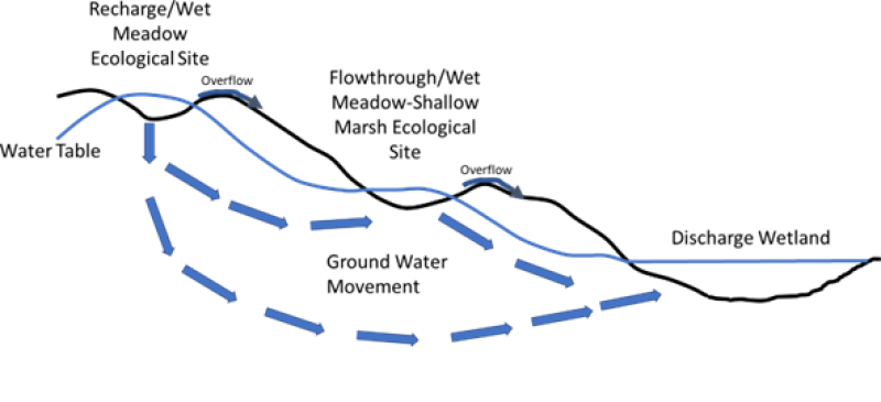
Figure 9. Surface/Subsurface Water Flow Diagram (Adapted from Seelig and DeKeyser 2006)
Soil features
Soils associated with Shallow Marsh ES are in the Mollisol and Vertisol orders; however, a few Histosols are also included. The Mollisols are classified further as Vertic Argiaquolls, Cumulic Vertic Epiaquolls, Typic Endoaquolls, Cumulic Endoaquolls, Typic Calciaquolls, and Histic Endoaquolls. The Vertisols are classified further as Typic Endoaquerts, Typic Epiaquerts, and Typic Calciaquerts. The Histosols are further classified as Terric Haplosaprists and Typic Haplosaprists. These soils were developed under wetland vegetation associated with very long periods of inundation. They formed in glaciolacustrine sediments, glaciofluvial deposits, eolian deposits, local alluvium from till, or flood plain alluvium. A few inches of organic materials are common on the surface of mineral soils that have never been cultivated. Histosols (soils with organic materials ranging from 8 inches to more than 3 feet thick) are not extensive.
The common feature of soils in this site is frequent seasonal inundation (typically extends into mid-summer or longer). Some are in deep depressions and potholes that are ponded through most of the growing season and some are on flood plains with frequent, long or very long flooding. The soils are very deep and very poorly drained. Since hydrology (surface and sub-surface) is the primary factor used in identifying this site, all textures are included. Therefore, soil physical properties associated with texture vary widely. The dark- colored surface soil is more than 7 inches thick and generally more than 20 inches thick; however, soils with thin topsoil layers (<7 inches thick) also occur.
Soil salinity is typically none to slight (E.C. <8 dS/m), but a few soils may have moderate salinity (E.C. 8 - <16 dS/m) in a subsoil layer. Sodicity is typically none or low; but in a few soils, the SAR may exceed 13 in a subsoil layer. Soil reaction typically is slightly acid to moderately alkaline (pH 6.1 to 8.4); but in a few soils may be strongly alkaline (pH 8.5 to 9.0) in a subsoil layer. The calcium carbonate content typically ranges from 0 to 35 percent; some soils have a subsoil layer with CaCO3 accumulations as high as 45 percent.
This site should show no evidence of rills, wind-scoured areas, or pedestaled plants. The soil surface is stable and intact. Sub-surface soil layers are non-restrictive to root penetration, but in some soils water movement downward is slowed. These soils are not susceptible to water erosion. Ponded water conditions strongly influence the soil/water/plant relationship.
Major soil series correlated to the Shallow Marsh site are Dovray, Parnell, Rauville, and Venlo. Very poorly drained phases of the Borup, Colvin, Fargo, Fossum, Hegne, Lowe, Manfred, Marysland, and Totten are also included in the site. Also included are Markey and Seelyeville which have surface organic materials greater than 8 inches thick.
Access Web Soil Survey (https://websoilsurvey.sc.egov.usda.gov/App/WebSoilSurvey.aspx) for specific local soils information.
Table 4. Representative soil features
| Parent material |
(1)
Alluvium
(2) Glaciofluvial deposits (3) Glaciolacustrine deposits (4) Till (5) Outwash |
|---|---|
| Surface texture |
(1) Silty clay loam (2) Silt loam (3) Loam (4) Silty clay (5) Fine sandy loam |
| Family particle size |
(1) Clayey (2) Sandy (3) Loamy |
| Drainage class | Very poorly drained |
| Permeability class | Very slow to very rapid |
| Depth to restrictive layer | 80 in |
| Surface fragment cover <=3" | 14% |
| Surface fragment cover >3" | Not specified |
| Calcium carbonate equivalent (0-40in) |
45% |
| Electrical conductivity (0-40in) |
16 mmhos/cm |
| Sodium adsorption ratio (0-40in) |
7 |
| Soil reaction (1:1 water) (0-40in) |
6.1 – 8.4 |
| Subsurface fragment volume <=3" (Depth not specified) |
35% |
| Subsurface fragment volume >3" (Depth not specified) |
2% |
Ecological dynamics
This ecological site description is based on nonequilibrium ecology and resilience theory and utilizes a State- and-Transition Model (STM) diagram to organize and communicate information about ecosystem change as a basis for management. The ecological dynamics characterized by the STM diagram reflect how changes in ecological drivers, feedback mechanisms, and controlling variables can maintain or induce changes in plant community composition (phases and/or states). Weather variables that dramatically change water depths and water chemistry, combined with the application of various management actions, impact the ecological processes which influence the competitive interactions, thereby maintaining or altering plant community structure. Due to these climatic and management factors, species composition within Plant Community Phases and States can be highly variable.
Drainage/Hydrological Manipulation: Hydrological manipulation (surface or tile drainage, pumping, surface water diversion, etc.) modifies this ecological site. For more detailed information on drainage/hydrological manipulation of the site, see the “Hydrology Functions” section of this document.
MLRA 55B has a wide variation of Shallow Marsh sites mainly driven by differences in water source and water chemistry. The Shallow Marsh ecological sites associated with sand plains in the MLRA are driven by ground water fluctuations and are mainly freshwater. Shallow Marsh ecological sites associated with till plains and lake plains commonly are driven by both ground water and runoff water (snowmelt and rainfall) from surrounding uplands. In some areas, this ground water can be saline and may impact the ecological site during the drawdown phase. In some Shallow Marsh ecological sites, water is also received from stream flow; typically, it has circumneutral pH (6.0–8.0) and high mineral and nutrient content. Refer to Site Development and Testing Plan section at end of this document.
This site developed under Northern Great Plains climatic conditions which included frequent droughts and wide fluctuations in temperature and precipitation which can result in both short-term and long-term changes in water levels and water chemistry (e.g., alkalinity/salinity). Unlike adjoining upland ecological sites, which are strongly influenced by grazing and fire, the primary ecological drivers for the Shallow Marsh ecological sites are hydrology and water chemistry. Hydrology is mainly a factor of landscape position, including the size of the contributing watershed, connectivity to other basins, ground water movement, and whether the basin has an outlet. Water chemistry is influenced by soil chemistry and whether the site is a recharge or flowthrough site.
Shallow Marsh ecological sites are highly influenced by water levels, including saturated soil, water movement, and water chemistry (i.e., recharge and flowthrough hydrology). Water levels, including soil saturation, influence fire effectiveness and livestock use. Water levels also influence exotic plant invasion. As Shallow Marsh sites drawdown (drying and losing soil moisture), they transition to functioning similar to Wet Meadow ecological sites and can increase in salinity/alkalinity. Salt and grazing tolerant foxtail barley can dominate the site during the drawdown phase. Extended periods of drawdown accompanied by grazing may cause this site to function similarly to a Saline Lowland or a Wet Meadow ecological site. Many factors will dictate the speed of exotic plant invasion including duration of drawdown phase, management of the sites during the drawdown phase, change in soil chemistry, and availability of exotic plant seed or plant parts. Exotic plant invasion usually begins to occur on adjacent Wet Meadow ecological sites, within or between basins, and then moves into the Shallow Marsh ecological site. During extended periods of drawdown, presence of exotic plants adjacent to the site and lack of fire or heavy continuous livestock grazing can speed up the invasion of foxtail barley and cool-season exotic grasses (e.g., quackgrass, barnyard grass) and forbs (such as Canada thistle or sowthistle). Extended periods of drawdown will also allow upland invasive plants, such as leafy spurge and Russian olive, to invade the site.
Once the site is invaded, increased water depth can inundate exotic plants to a depth above plant height, causing considerable mortality, allowing restoration from the State 2: Native/Invaded State to the State 1: Reference State. Salt accumulation will be difficult to reverse back to levels prior to extended periods of drawdown and may take extended periods of inundation. In addition, exotic grasses (e.g., quackgrass) and foxtail barley can tolerate extended periods of inundation or saturation, which may never totally drown out along the outer margins of the adjacent Wet Meadow or Saline Lowland ecological sites. The continued presence of cool-season exotic grasses will cause this site to transition from State 1: Reference State and State 2: Native/Invaded State as water levels naturally fluctuate.
During extended periods of drawdown, heavy season-long grazing without adequate recovery periods following each grazing occurrence favors foxtail barley (i.e., Community Phase 2.2). During periods of normal water level, extended periods of non-use or no fire often favor exotic strains of reed canarygrass or hybrid cattail (i.e., Community Phase 2.1). Annual cropping of the site or adjacent upland sites increases nutrient and sediment movement into this ecological site favoring hybrid cattail (i.e., State 3.0 Invaded State).
At times, particularly during periods of soil saturation with little standing water, Shallow Marsh sites may be susceptible to pugging damage (or hummocking of the soil by livestock walking on the site). Pugging is a form of soil compaction due to livestock activity which damages the soil structure. It can seal the soil surface which reduces infiltration and exacerbates waterlogging of the topsoil. The micro-topography created by pugging generally supports plants of more well drained conditions (e.g., adjacent uplands) and is often associated with an increase in weedy species. This can lead to a significant reduction in herbage production and utilization.
Four vegetative states have been identified for the site (Reference, Native/Invaded, Invaded, and Go-Back). Within each state, one or more community phases have been identified. These community phases are named based on the more dominant water phases and visually conspicuous species; they have been determined by study of historical documents, relict areas, scientific studies, and ecological aspects of plant species and plant communities. However, this ecological site is quite dynamic due to wide variations in water depth, water chemistry and other environmental factors. Management factors are also widely variable. As a result, the species composition and productivity of all states and community phases can vary considerably. Transitional pathways and thresholds have been determined through similar methods.
State 1: Reference State represents the natural range of variability that dominated the dynamics of this ecological site prior to European influence when the primary disturbance mechanisms for this site included water level fluctuations. Periodic fire and grazing by large herding ungulates were not a major disturbance mechanism. Spring snowmelt runoff and rainfall events, coupled with subsurface groundwater movement, dictated the dynamics that occurred within the natural range of variability. Due to those variations, the Reference State is thought to have shifted temporally and spatially between four Plant Community Phases.
Water level fluctuations and water chemistry are the present-day primary disturbances. However, during drawdown phases, livestock grazing and a lack of fire impact this ecological site. Because of the changes in these and other environmental factors, the Reference State is becoming increasingly rare. Once adjacent upland ecological sites are converted to cropland, the Reference State can no longer exist due to sedimentation and increased nutrient loading to the site. The presence of exotic species on the site precludes it from being placed in the Reference State. It must then be placed in one of the other states, commonly State 2: Native/Invaded State (T1A) or State 3: Invaded State (T1B).
State 2: Native/Invaded State. Colonization of the site by exotic plants results in a transition from State 1: Reference State to State 2: Native/Invaded State (T1A). This transition is probably inevitable; it often results from colonization by exotic plants or their hybrids, commonly hybrid cattail or exotic strains/hybrids of reed canarygrass.
Three community phases have been identified for this state. The exotic species/hybrids can be expected to increase. Hybrid cattail and exotic strains/hybrids of reed canarygrass tend to form virtual monocultures and, as such, plants more desirable to wildlife and livestock decline.
Maintenance of communities on the periphery of the wetland (e.g., Wet Meadow ecological site, adjacent upland sites) are critical to the ecological integrity/functioning of the wetland ecosystem. If a buffer zone (50 feet minimum) is not maintained, an increase in eutrophication, sedimentation rate, and invasion by exotic plants can be expected. For more information on buffer widths please refer to the Gilbert et.al. (2006) in the references section.
To slow or limit the invasion of these exotic plants and their hybrids, it is imperative that managerial techniques (e.g., prescribed grazing, prescribed burning, maintaining intact buffers) be carefully constructed, monitored, and evaluated with respect to that objective. If management does not include measures to control or reduce these exotic plants, the transition to State 3: Invaded State should be expected (T2A). An increase in water depth, however, may drown out the exotic plants leading to State 1: Reference State (R2A).
State 3: Invaded State. The threshold for this state may be reached when hybrid cattail or the exotic strains/hybrids of reed canarygrass exceed 30% of the plant community and native plants represent less than 40% of the community. One plant community phase has been identified for this state. This state is typically dominated by hybrid cattail or exotic strains/hybrids of reed canarygrass. These species typically form virtual monocultures; as a result, plant diversity is low and habitat suitability for some wildlife species is low as well (e.g., hybrid cattail dominated wetlands may not provide waterfowl habitat but may provide white-tailed deer winter habitat).
A restoration pathway to State 2: Native/Invaded State may be accomplished with the implementation of a successful wetland restoration or planting, increased water regime, vegetative chemical treatment, and/or sediment/nutrient removal (R3A). This pathway may be difficult and expensive. A failed wetland restoration or planting will remain in State 3: Invaded State.
State 4: Go-Back State often results following cropland abandonment during periods of extended, below average precipitation or drought and consists of only one plant community phase which often is composed of a variety of annual forbs, grasses, spike rushes, etc. including noxious weeds (e.g., Canada thistle) which may need control. Over time, the site will likely become dominated by exotic strains or hybrids of reed canarygrass and/or hybrid cattail. Cessation of annual cropping followed by a successful wetland restoration/planting with prescribed burning and vegetative management may lead to State 2: Native/Invaded State (R4A). A failed wetland restoration/planting with non-use and no fire will likely lead to State 3: Invaded State (R4B).
The following state and transition model diagram illustrates the common states, community phases, community pathways, and transition and restoration pathways that can occur on the site. These are the most common plant community phases and states based on current knowledge and experience; changes may be made as more data are collected. Pathway narratives describing the site’s ecological dynamics reference various water regimes and are influenced by management practices (e.g., prescribed grazing, prescribed burning, brush management, herbaceous weed treatment) which, if properly designed and implemented, will positively influence plant community competitive interactions. The design of these management practices will be site specific and should be developed by knowledgeable individuals; based upon management goals and a resource inventory; and supported by an ongoing monitoring protocol.
Due to variations in management, climate, and other factors the botanical composition within Plant Community Phases and States can be highly variable. The sites are primarily driven by water depth and water chemistry (local and regional). When the management goal is to maintain an existing plant community phase, modification of existing management to ensure native species have the competitive advantage may be required. To restore a previous state, or restore to another phase within the same state, water depth and water chemistry may need to be modified, which is rarely available to managers except under hydrological restoration applications. Whether using prescribed grazing, prescribed burning, or a combination of both with or without additional practices, the timing and method of application needs to favor the native species over the exotic species. Adjustments to account for variations in annual growing conditions and implementing an ongoing monitoring protocol will be necessary to track changes and adjust management inputs to ensure desired outcomes. The plant community phase composition table(s) has been developed from the best available knowledge including research, historical records, clipping studies, and inventory records. As more data are collected, plant community species composition and production information may be revised.
State and transition model

More interactive model formats are also available.
View Interactive Models
Click on state and transition labels to scroll to the respective text
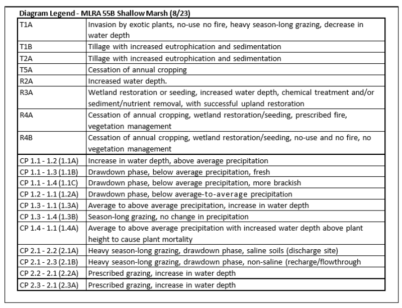
Ecosystem states
| T1A | - | Invasion by exotic plants, no-use no fire, heavy season-long grazing, decrease in water regime |
|---|---|---|
| R2A | - | Increased water depth |
| T2A | - | Tillage with increased eutrophication and sedimentation |
| R3A | - | Successful wetland restoration or seeding, increased water depth, chemical treatment and/or sediment/nutrient removal, with successful buffer or upland restoration |
| R4A | - | Cessation of annual cropping, successful wetland restoration/seeding, prescribed fire, vegetation management |
| R4B | - | Cessation of annual cropping, failed wetland restoration/seeding, no-use and no fire |
| T5A | - | Cessation of annual cropping |
State 1 submodel, plant communities
| 1.1A | - | Increase in water depth, above normal precipitation |
|---|---|---|
| 1.1B | - | Drawdown phase, below normal precipitation, fresh |
| 1.1C | - | Drawdown phase, below normal precipitation, more brackish |
| 1.2A | - | Drawdown phase, below normal to normal precipitation |
| 1.3A | - | Normal to above normal precipitation, increase in water depth |
| 1.3B | - | Season-long grazing, no change in precipitation |
| 1.4A | - | Average to above average precipitation with increased water depth above plant height to cause plant mortality |
State 2 submodel, plant communities
| 2.1A | - | Heavy season-long grazing, drawdown phase, saline soils (discharge site) |
|---|---|---|
| 2.2A | - | Prescribed grazing, increase in water depth |
| 2.3A | - | Prescribed grazing, increase in water depth |
State 3 submodel, plant communities
State 4 submodel, plant communities
State 1
Reference
This state represents the natural range of variability that dominated the dynamics of this ecological site prior to European settlement. Historically, the primary disturbance mechanisms for this site in the reference condition were large fluctuations of the water table, water levels, soil saturation, and water chemistry (e.g., brackishness/ salinity/ alkalinity). Periodic fire and grazing by large herding ungulates were also historical disturbances that influenced this site but to a much lesser degree. Climate, weather, and drawdown events (combined with the timing of fires and grazing) dictated the dynamics that occurred within the natural range of variability. Presently, the main disturbances are climate, weather events, water level fluctuations, lack of fire, concentrated livestock grazing, and agronomic activities on adjacent ecological sites (e.g., tillage, fertilizer and herbicide use, drainage). The Reference State is composed of four community phases. These phases are largely due to weather and climate factors resulting in considerable fluctuations in water levels and water chemistry (e.g., brackishness). Brackishness, along with water depth, is also a major factor influencing vegetation of the site. Brackishness can be natural due to the type of hydrology and soils of the site. Exotic perennial plant species do not exist in this state.
Characteristics and indicators. Exotic species and hydrologic manipulation would not be present on this site when it is in State 1: Reference State
Resilience management. If intact, the reference state should be managed with current disturbance regimes which has permitted the site to remain in reference condition as well as maintaining the quality and integrity of associated ecological sites. Maintenance of the reference state is contingent upon a monitoring protocol to guide management.
Community 1.1
Normal Emergent Phase: Grasses/Sedges-Spikerushes-Bulrushes (Grasses/Carex spp.-Eleocharis spp.-Scripus spp., Schoenoplectus spp.)
This community phase was historically the most dominant both temporally and spatially. Botanical composition can be quite variable due to variations in water chemistry and other factors. It is often dominated by tall and mid, cool-season grasses along with sedges, spikerushes and bulrushes. The dominant grasses include common rivergrass (aka whitetop), mannagrass (i.e., American mannagrass, fowl mannagrass), slimstem reedgrass, bluejoint and American sloughgrass. Wheat sedge is the primary sedge; bulrushes may include common threesquare (may become dominant in brackish waters); and spikerush includes common spikerush and needle spikerush. Common forbs include bur-reed (mostly broadfuit bur-reed), spotted water hemlock, hemlock water parsnip, water knotweed, and common bladderwort. Moss (Drepanocladus spp.) often covers much of the soil surface during drawdown phase. Bulrushes (such as hardstem, river, or softstem) may also be present in the transition zone to open water. Fowl bluegrass, northern reedgrass, and prairie cordgrass along with various forbs and sedges occur in the transition zone to Wet Meadow ecological sites. Annual production can be quite variable but may range from 5500-7500 pounds per acre. This is the reference plant community phase and is described in the “Plant Community Composition and Group Annual Production” portion of this ecological site description.
Figure 10. Annual production by plant type (representative values) or group (midpoint values)
Table 5. Annual production by plant type
| Plant type | Low (lb/acre) |
Representative value (lb/acre) |
High (lb/acre) |
|---|---|---|---|
| Grass/Grasslike | 4400 | 4876 | 5550 |
| Forb | 1100 | 1625 | 1950 |
| Total | 5500 | 6501 | 7500 |
Figure 11. Plant community growth curve (percent production by month). ND5506, Central Black Glaciated Plains, lowland cool-season dominant.. Cool-season dominant, lowland..
| Jan | Feb | Mar | Apr | May | Jun | Jul | Aug | Sep | Oct | Nov | Dec |
|---|---|---|---|---|---|---|---|---|---|---|---|
| J | F | M | A | M | J | J | A | S | O | N | D |
| 0 | 0 | 3 | 10 | 37 | 35 | 5 | 2 | 8 | 0 | 0 | 0 |
Community 1.2
Open Water Phase: Submergent Vegetation-Buttercups (Submergent Vegetation-Ranunculus spp.)
This community phase occurs when increased precipitation or other factors cause the water levels to increase in depth for a sufficient period of time for the site to become dominated by open water submergent species, such as buttercup (e.g., yellow water buttercup, longbeak buttercup). With a decrease in water levels (e.g., return to average precipitation/runoff), the plant community should return to Community Phase 1.1. Annual production can be quite variable due to wide variations in water chemistry, hydrology, and other factors.
Community 1.3
Drawdown Phase, Fresh: Grasses/Sedges-Spikerushes/ (Grasses/Carex spp.-Eleocharis spp.)
This community phase occurs during prolonged dry periods or other factors leading to decreased water depth with fresh-water conditions. Woolly sedge, spikerush (e.g., common spikerush, needle spikerush), slimstem reedgrass, and other sedges from the adjacent, drier sites encroach onto the site. With an increase in water depth (e.g., return to average precipitation) the plant community will readily return to Community Phase 1.1. Annual production can be quite variable due to wide variations in water chemistry, hydrology, and other factors.
Community 1.4
Drawdown Phase, Brackish: Foxtail Barely/Spikerushes/Docks- Goosefoots (Hordeum jubatum/Eleocharis spp./Rumex spp./Chenopodium spp.)
This community phase occurs on some wetland soils during a drawdown phase causing more brackish conditions, perhaps coupled with heavy season-long grazing. This leads to marked increases in foxtail barley, spikerush (e.g., common spikerush, needle spikerush), speedwell, dock (e.g., golden dock, western dock), and goosefoot (e.g., red goosefoot). American sloughgrass, knotweeds, and cinquefoils can also be common associates of this community phase. Annual production and the extent of bare ground can be quite variable. With continued heavy season-long grazing, increased soil compaction may result in high amounts of bare ground or in the colonization of exotic forbs and grasses. If this occurs, the site will likely begin transition to State 2: Native/Invaded State or State3: Invaded State. .
Pathway 1.1A
Community 1.1 to 1.2
Community Phase 1.1 to 1.2 occurs with above average precipitation or other factors causing an increase in water depth sufficient to shift the vegetation from a diverse mixture of grasses, sedges, spikerushes, and bulrushes to one with more extensive open water supporting buttercup.
Pathway 1.1B
Community 1.1 to 1.3
Community Phase 1.1 to 1.3 occurs with below average precipitation or other factors causing a drawdown phase with fresh water, shifting the vegetation to woolly sedge, spikerush, and slimstem reedgrass.
Pathway 1.1C
Community 1.1 to 1.4
Community Phase 1.1 to 1.4 occurs during a drawdown phase with the water becoming more brackish. This shifts the dominant vegetation from a diverse mixture of grasses, sedges, spikerushes and bulrushes, to foxtail barley, spikerush, and dock.
Pathway 1.2A
Community 1.2 to 1.1
Community Phase Pathway 1.2 to 1.1 occurs during times of below average precipitation or other conditions that result in a drawdown phase or drop in water levels sufficient to cause a shift in the vegetation from submergent species such as buttercup to a diverse mixture of grasses, sedges, spikerushes and bulrushes.
Pathway 1.3A
Community 1.3 to 1.1
Community Phase Pathway 1.3 to 1.1 occurs during times of above average precipitation leading to an increase in water depth sufficient to cause a shift in the dominant vegetation from woolly sedge, spikerush, and slimstem reedgrass to a diverse mixture of grasses, sedges, spikerushes and bulrushes.
Pathway 1.3B
Community 1.3 to 1.4
Community Phase Pathway 1.3 to 1.4 occurs with heavy season-long grazing leading to a change from grasses, woolly sedge, spikerush, and slimstem reedgrass to one dominated by foxtail barley, spikerush, and dock.
Pathway 1.4A
Community 1.4 to 1.1
Community Phase Pathway 1.4 to 1.1 occurs with above average precipitation or other factors causing an increase in water depth sufficient to shift the vegetation from foxtail barley and associates to a diverse mixture of grasses, sedges, spikerushes and bulrushes.
State 2
Native/Invaded State
This state is characterized by the colonization and establishment of minor amounts of exotic plants. Reed canarygrass is native to North America, but exotic strains (largely Eurasian) have been widely introduced and, along with their hybrids, can be quite invasive. Hybrid cattail, the hybrid between narrowleaf cattail and broadleaf cattail is also a common exotic. Canada thistle is also known to invade the site during dry periods. Although the site is still dominated by native plants, an increase in exotic plants can be expected. Unless a prescribed grazing and/or prescribed burning program is implemented or an increase in water depth drowns out exotic species, a transition to State 3: Invaded State can be expected.
Characteristics and indicators. The presence of trace amounts of exotic species/hybrids (e.g., cattail, reed canarygrass) indicates a transition from State 1 to State 2.
Resilience management. Implementation of management techniques and monitoring procedures designed to limit or control exotic species/hybrids.
Community 2.1
Normal Emergent Phase: Grasses/
Sedges-Spikerushes-Bulrushes/Exotics (Grasses/Carex spp.-Eleocharis spp.-Scripus spp., Schoenoplectus spp./Exotics)

Figure 12. Restoration pathway R3A - Plant Community Phase 2.1 – Sediment removal, no seeding, plant community consisting of sedges, common rivergrass (aka whitetop), fowl bluegrass, nut sedge, spikerush, foxtail barley, reed canarygrass, hybrid cattail, etc.
This is the wetter community phase of State 2: Native/Invaded State. This community is similar to Community Phase 1.1. However, exotic species (such as exotic strains/hybrids of reed canarygrass or hybrid cattail, curly dock, narrowleaf dock, oakleaf goosefoot, marshpepper knotweed, spotted ladysthumb, and others) are now minor components of the community. Annual production can be quite variable due to wide variations in water chemistry, hydrology, and other factors.
Community 2.2
Drawdown Phase, Brackish: Foxtail Barely/Spikerushes/Exotics (Hordeum jubatum/ Eleocharis spp./ Exotics)
This is the drier, brackish community phase in State 2: Native/Invaded State. It is dominated by foxtail barley in association with spikerush, dock, and various native forbs (such as water knotweed, Mexican dock, curlytop knotweed, Pursh seepweed, goosefoot, and others). Exotic plants may include exotic strains/hybrids of reed canarygrass (as well as hybrid cattail, curly dock, narrowleaf dock, oakleaf goosefoot, marshpepper knotweed, spotted ladysthumb, and others) which are now minor components of the community. Absinthium (aka wormwood) may also become prominent if the basin dries-up. Annual production and the extent of bare ground can be quite variable.
Community 2.3
Drawdown Phase, Fresh: Spikerushes/Hybrid Cattail (Eleocharis spp./Typha x glauca)
This is the drier, fresher community phase in State 2: Native/Invaded State. It is dominated by spikerushes and hybrid cattail. Swamp ragwort, kochia, cocklebur, pale smartweed, and other rather weedy forbs are also common. Exotic strains/hybrids of reed canarygrass and common reed may also become minor components of the community. Absinthium (aka wormwood), Canada thistle, and sow thistle may also become prominent if the basin dries-up.
Pathway 2.1A
Community 2.1 to 2.2
Community Phase Pathway 2.1 to 2.2 occurs with heavy-season-long grazing coupled with a drawdown phase and saline soils (discharge site). As the pathway progresses, native plant diversity declines while foxtail barley, spikerush, sedges, knotweed, dock, and exotic forbs increase.
Pathway 2.1B
Community 2.1 to 2.3
Community Phase Pathway 2.1 to 2.3 occurs with heavy-season-long grazing coupled with a drawdown phase and non-saline soils (recharge/flowthrough site). As the pathway progresses the site becomes more dominated by spikerushes and hybrid cattail.
Pathway 2.2A
Community 2.2 to 2.1
Community Phase Pathway 2.2 to 2.1 occurs with the implementation of prescribed grazing with the return to near average precipitation resulting in increased water depth. This leads to a shift from foxtail barley, spikerush, dock, and exotic forbs to one of a diverse mixture of grasses, sedges, spikerushes, and bulrushes along with exotic grasses and exotic forbs.
Pathway 2.3A
Community 2.3 to 2.1
Community Phase 2.3 to 2.1 occurs with the implementation of prescribed grazing with the return to near average precipitation resulting in increased water depth. This leads to increasing prevalence of emergent species such as bulrushes, spikerushes, and sedges.
State 3
Invaded State
This state occurs when the site becomes dominated by exotic plants. Common exotics of the site include exotic strains/hybrids of reed canarygrass or hybrid cattail. Other exotic species may include Canada thistle, purple loosestrife, flowering rush, and exotic strains/hybrids of common reed. Once the state is established, restoration efforts have proven difficult (see Restoration R3A).
Characteristics and indicators. This site is characterized by exotic species/hybrids dominating the site and controlling the ecological processes (i.e. approximately 30 to 40%).
Resilience management. Once established, reed canarygrass and hybrid cattail are very resilient and will withstand grazing, haying pressure and non-use.
Community 3.1
Hybrid Cattail and/or Reed Canarygrass (Typha x glauca or Phalaris arundinacea)
Hybrid cattail or exotic strains/hybrids of reed canarygrass often dominate State 3: Invaded State. Whether hybrid cattail or reed canarygrass dominate the site is largely determined by which species propagules (presence/abundance) are present on the site. Diversity plummets with dominance by either of these species, as both form monotypic stands. Hybrid cattail is the hybrid of narrowleaf cattail and broadleaf cattail. The hybrid is also known to backcross with the broadleaf cattail. It is widely regarded as aggressive or invasive and typically forms monotypic stands. It is particularly adapted to nutrient enriched habitats with high sedimentation (i.e., associated with tillage, siltation, drainage). Reed canarygrass is native to North America, but exotic strains have repeatedly been introduced over the years. These exotic strains and their hybrids are regarded as aggressive or invasive, often forming monotypic stands. Reed canarygrass and hybrid cattail are highly adaptive and managerial efforts to control them has been difficult (see Restoration R3A). Annual production can be quite variable due to wide variations in water chemistry, hydrology, and other factors.
State 4
Go-back State
This state is highly variable depending on the level and duration of disturbance related to the T5A pathway. In this MLRA, the most probable origin of this state is plant succession following crop abandonment. This plant community will initially include a variety of annual forbs and grasses, some of which maybe noxious weeds.
Characteristics and indicators. Tillage has destroyed the native plant community, altered soil structure and biology, increased eutrophication, reduced soil organic matter, and results in the formation of a tillage induced compacted layer which is restrictive to root growth. Noxious weeds, if present, will need to be managed.
Resilience management. Continued tillage will maintain the state. Control of noxious weeds will be required.
Community 4.1
Annual/Pioneer Perennial/Exotics
This community phase may be quite variable in composition. Vegetation is generally a mix of pioneer species, both native and exotic, as well as some native and exotic perennials such as foxtail barley, reed canarygrass, slough grass, spikerush, speedwell, dock, goosefoot, knotweeds, absinth wormwood, Canada thistle, hybrid cattail, water horehound, field sowthistle, and others. Annual production can be quite variable due to wide variations in water chemistry, hydrology, and other factors.
State 5
Any Plant Community
Most commonly, it is associated with the cessation of cropping without the benefit of restoration efforts, resulting in a “go-back” situation
Transition T1A
State 1 to 2
This is the transition from the State 1: Reference State to State 2: Native/Invaded State resulting from the colonization and establishment of exotic plants, often exotic strains of reed canarygrass or hybrid cattail. Canada thistle is also known to invade the site during dry periods. Heavy season-long grazing, prolonged periods of non-use and no fire, and a decrease in the water regime of the site are often involved with this transition. Excessive litter accumulation provides conditions favorable to hybrid cattail or exotic strains/hybrids of reed canarygrass which can quickly spread to form virtual monocultures. As a result, the transition to State 3: Invaded State can be expected.
Constraints to recovery. Restoration to State 1 is dependent upon hydrology, condition of adjacent upland ecological sites (i.e., cropland), and abundance of exotic species.
Transition T1B
State 1 to 3
This is the transition from State 1: Reference State to State 3: Invaded State. Although the State 3: Invaded State often forms via State 2: Native/Invaded State, this direct transition to State 3: Invaded State can occur with tillage of the Shallow Marsh ecological site or adjacent upland with an associated increase in eutrophication and sedimentation resulting in vegetation dominance by hybrid cattail or exotic strains/hybrids of reed canarygrass.
Constraints to recovery. Restoration to State 1 is dependent upon hydrology, condition of adjacent upland ecological sites (i.e., cropland), and abundance of exotic species.
Context dependence. Tillage with increased eutrophication and sedimentation
Restoration pathway R2A
State 2 to 1
This restoration pathway from State 2: Native/Invaded State to State 1: Refence State is initiated by an increase in water depth sufficient to drown out invasive exotic species. Success of this pathway is dependent upon the invasive species present in State 2 Native/Invaded State. Hybrid cattail, reed canary grass, or perhaps exotic strains of common reed will likely persist with increased water levels, whereas foxtail barley, dock, or Canada and sow thistle will drown out.
Context dependence. Hydrological restoration/management to remove exotic species/hybrids which may necessitate chemical control. Adjacent upland ecological sites will need to remain intact or reseeded to native species in order to prevent sedimentation and nutrient loading to Shallow Marsh ecological site. Prescribed grazing techniques may provide a short-term reduction in reed canarygrass density; however, a combination of mowing and prescribed burning may be more effective than prescribed grazing alone.
Transition T2A
State 2 to 3
The transition from State 2: Native/Invaded State to State 3: Invaded State can occur with tillage within the site or on adjacent upland sites resulting in an increase in eutrophication and sedimentation leading to a dominance of hybrid cattail or exotic strains/hybrids of reed canarygrass. Studies indicate that a threshold may exist in the transition to this Native/Invaded State on some upland ecological sites when Kentucky bluegrass exceeds 30% of the plant community and native grasses represent less than 40% of the plant community composition. Similar thresholds may exist for exotic strains of reed canarygrass and hybrid cattail on this site.
Constraints to recovery. Restoration to State 2 is dependent upon hydrology and abundance of exotic species/hybrids.
Restoration pathway R3A
State 3 to 2
This restoration pathway from State 3: Invaded State to State 2: Native/Invaded State results from a successful wetland restoration through hydrological restoration, planting, increased water regime, chemical treatment, and/or sediment/nutrient removal. A successful upland restoration is also needed to reduce the likelihood of exotic plant invasion or continued sedimentation or nutrient loading.
Context dependence. Reed canarygrass and hybrid cattail are difficult to control, largely due to vigorous spreading rhizomes, high seed production, and a large seed bank. Various control techniques may show signs of success but are often short-term with vegetation reverting within a few years. Adjacent upland ecological sites will need to remain intact or be reseeded to native species to prevent sedimentation and nutrient loading to Shallow Marsh ecological site. Prescribed grazing (e.g., heavy seasonal), high-intensity burns, and herbicides have shown some success in reducing the dominance by reed canarygrass. However, within several years the vegetation often reverts. Herbicides can be effective in reducing or eliminating hybrid cattail and can be followed by reseeding (or plugging) desirable species. Prescribed burning has also been effective during dry periods where fire temperatures may kill rhizomes and seeds. Although expensive, mechanical removal of the substrate has also been an effective technique.
Restoration pathway R4A
State 4 to 2
This restoration pathway from State 4: Go-Back State to State 2: Native/Invaded State results from cessation of annual cropping, successful wetland restoration/seeding/plugging, prescribed burning, and vegetation management
Context dependence. If manipulated, hydrology needs to be restored. Elevated soil nitrogen levels and sedimentation have been shown to benefit reed canarygrass and hybrid cattail. Sedimentation may need to be removed to preexisting conditions. A successful range planting will include proper seedbed preparation, weed control (both prior to and after the planting), selection of adapted native species representing functional/structural groups inherent to the State 1, and proper seeding technique. Management (e.g. prescribed grazing, prescribed burning) during and after establishment must be applied in a manner that maintains the competitive advantage for the seeded native species.
Restoration pathway R4B
State 4 to 3
This restoration pathway from State 4: Go-Back State to State 3: Invaded State results from cessation of annual cropping followed by a failed wetland restoration/seeding with no use and no fire.
Context dependence. Failure to restore hydrology and failed range plantings can result from many causes, both singularly and in combination, including: drought, poor seedbed preparation, improper seeding methods, seeded species not adapted to the site, insufficient weed control, herbicide carryover, poor seed quality (purity & germination), improper management.
Restoration pathway T5A
State 5 to 4
This transition from any plant community to State 4: Go-Back State. Most commonly, it is associated with the cessation of cropping without the benefit of restoration efforts, resulting in a “go-back” situation. Soil conditions can be quite variable on the site, in part due to variations in the management/cropping history (e.g. development of a tillage induced compacted layer, erosion, fertility (degree of eutrophication), sedimentation herbicide/pesticide carryover). Thus, soil conditions should be assessed when considering restoration techniques.
Additional community tables
Table 6. Community 1.1 plant community composition
| Group | Common name | Symbol | Scientific name | Annual production (lb/acre) | Foliar cover (%) | |
|---|---|---|---|---|---|---|
|
Grass/Grasslike
|
||||||
| 1 | Grass-likes | 1625–2600 | ||||
| wheat sedge | CAAT2 | Carex atherodes | 650–2600 | – | ||
| spikerush | ELEOC | Eleocharis | 130–650 | – | ||
| Grass-like (not a true grass) | 2GL | Grass-like (not a true grass) | 65–520 | – | ||
| softstem bulrush | SCTA2 | Schoenoplectus tabernaemontani | 0–325 | – | ||
| hardstem bulrush | SCAC3 | Schoenoplectus acutus | 0–325 | – | ||
| woolly sedge | CAPE42 | Carex pellita | 0–325 | – | ||
| bottlebrush sedge | CAHY4 | Carex hystericina | 0–325 | – | ||
| Sartwell's sedge | CASA8 | Carex sartwellii | 0–195 | – | ||
| chairmaker's bulrush | SCAM6 | Schoenoplectus americanus | 0–195 | – | ||
| mountain rush | JUARL | Juncus arcticus ssp. littoralis | 0–195 | – | ||
| rush | JUNCU | Juncus | 0–195 | – | ||
| 2 | Grasses | 650–1625 | ||||
| American mannagrass | GLGR | Glyceria grandis | 130–975 | – | ||
| fowl mannagrass | GLST | Glyceria striata | 130–975 | – | ||
| American sloughgrass | BESY | Beckmannia syzigachne | 65–650 | – | ||
| common rivergrass | SCFE | Scolochloa festucacea | 0–650 | – | ||
| Graminoid (grass or grass-like) | 2GRAM | Graminoid (grass or grass-like) | 0–325 | – | ||
| prairie cordgrass | SPPE | Spartina pectinata | 0–195 | – | ||
| northern reedgrass | CASTI3 | Calamagrostis stricta ssp. inexpansa | 0–195 | – | ||
| reed canarygrass | PHAR3 | Phalaris arundinacea | 0–195 | – | ||
|
Forb
|
||||||
| 3 | Forbs | 975–2275 | ||||
| broadfruit bur-reed | SPEU | Sparganium eurycarpum | 325–1300 | – | ||
| Forb, native | 2FN | Forb, native | 65–325 | – | ||
| northern water plantain | ALTR7 | Alisma triviale | 65–195 | – | ||
| Pennsylvania smartweed | POPE2 | Polygonum pensylvanicum | 65–195 | – | ||
| hemlock waterparsnip | SISU2 | Sium suave | 65–195 | – | ||
| hedgenettle | STACH | Stachys | 65–195 | – | ||
| broadleaf cattail | TYLA | Typha latifolia | 0–195 | – | ||
| American water horehound | LYAM | Lycopus americanus | 65–130 | – | ||
| swamp smartweed | POHY2 | Polygonum hydropiperoides | 65–130 | – | ||
| curlytop knotweed | POLA4 | Polygonum lapathifolium | 65–130 | – | ||
| cinquefoil | POTEN | Potentilla | 65–130 | – | ||
| Macoun's buttercup | RAMA2 | Ranunculus macounii | 65–130 | – | ||
| pale dock | RUAL4 | Rumex altissimus | 65–130 | – | ||
| western dock | RUAQ | Rumex aquaticus | 65–130 | – | ||
| marsh skullcap | SCGA | Scutellaria galericulata | 65–130 | – | ||
| New England aster | SYNO2 | Symphyotrichum novae-angliae | 65–130 | – | ||
| knotweed | POLYG4 | Polygonum | 0–130 | – | ||
| giant goldenrod | SOGI | Solidago gigantea | 0–130 | – | ||
| Indianhemp | APCA | Apocynum cannabinum | 0–65 | – | ||
| swamp milkweed | ASIN | Asclepias incarnata | 0–65 | – | ||
| smooth horsetail | EQLA | Equisetum laevigatum | 0–65 | – | ||
| rough bugleweed | LYAS | Lycopus asper | 0–65 | – | ||
| marsh fleabane | SECO2 | Senecio congestus | 0–65 | – | ||
| white panicle aster | SYLA6 | Symphyotrichum lanceolatum | 0–65 | – | ||
| marsh arrowgrass | TRPA28 | Triglochin palustris | 0–65 | – | ||
Interpretations
Animal community
Animal Community – Wildlife Interpretations
Landscape
The MLRA 55B landscape is characterized by mostly nearly level to gently rolling till plains with some steep slopes adjacent to streams and many poorly defined drainage channels. The continental drainage divide occurs in the east central part of the MLRA. The MLRA is located within the Prairie Pothole Region with temporary, seasonal, and semi-permanent wetlands throughout the MLRA. The MLRA includes areas of eskers, kames, and ground moraines. MLRA 55B is considered to have a continental climate with cold winters and hot summers, low humidity, light rainfall, and much sunshine. Extremes in temperature are common and characteristic of the MLRA. This area supports mid- to tall-grass prairie vegetation with American elm, bur oak, green ash, and willow species growing along the riparian zones of river systems found throughout the MLRA. Complex intermingled ecological sites create diverse grass/shrub land habitats interspersed with varying densities of linear, slope, depressional, and in-stream wetlands associated with headwater streams and tributaries of the James, Pipestem, Maple, Goose, Sheyenne, Wild Rice, and Elm Rivers. MLRA 55B is located within North and South Dakota and within the boundaries of the Prairie Pothole Region.
Three Hydrologic Unit Areas make up this MLRA. Approximately 6% drains into the Mouse River into MLRA 55A, with the balance split between the James and Sheyenne Rivers.
By the mid-19th century, over 76% of the MLRA had been converted from mid- to tall-grass prairie to annual crop production. To alleviate crop production loss from wetlands and overland flow, a system of shallow surface ditches, judicial ditches, and road ditches removes surface water in spring and during high rainfall events. Tile drainage systems have been or are being installed extensively throughout MLRA 55B for sub-surface field drainage to enhance annual crop production.
Historic Communities/Conditions within MLRA 55B:
The northern tall- and mixed-grass prairie were disturbance-driven ecosystems with fire, herbivory, and climate functions as the primary ecological drivers (either singly or often in combination). American bison roamed MLRA 55B, wintering along the Mouse River in MLRA 55A and migrating through MLRA 55B and into MLRA 56A. Many species of grassland birds, small mammals, insects, reptiles, amphibians, elk, moose, pronghorn, white-tailed deer, and large herds of American bison were historically among the inhabitants adapted to this region. Roaming herbivores, as well as several small mammals and insect species, were the primary consumers linking the grassland resources to large predators (such as the wolf, American black bear, grizzly bear) and smaller carnivores (such as the coyote, bobcat, red fox, and raptors). Extirpated species include free- ranging American bison and gray wolf (breeding). Extinct is the Rocky Mountain locust.
Present Communities/Conditions within MLRA 55B:
This area supports natural prairie vegetation characterized by western wheatgrass, green needlegrass, needle and thread, and blue grama. Little bluestem is an important species on the more sloping and shallower soils. Prairie cordgrass, northern reedgrass, big bluestem, and wheat sedge (aka slough sedge) are important species on wet soils. Western snowberry, leadplant, and prairie rose are commonly interspersed throughout the area.
Over 80% of MLRA 55B has been converted to annual crop production. These influences fragmented the landscape, reduced or eliminated ecological drivers (fire), and introduced exotic plant species including smooth brome, crested wheatgrass, Kentucky bluegrass, and leafy spurge; this further impacted plant and animal communities. The loss of the bison and fire as primary ecological drivers greatly influenced the character of the remaining native plant communities and the associated wildlife, moving towards a less diverse and more homogeneous landscape. Annual cropping is the main factor contributing to habitat fragmentation, reducing habitat quality for area- sensitive species.
Hydrological manipulation is extensive throughout the MLRA. Extensive wetland and subsurface tile drainage have taken place. Straightened segments of ephemeral and intermittent tributary streams of the James, Wild Rice, and Sheyenne River have reduced sinuosity, created oxbows, and enabled the conversion of riparian ecological sites to annual crop production. These anthropogenic impacts have reduced flood water detention and retention on the landscape. The results have been increasing storm water runoff sediment and nutrient loading to the James and Sheyenne Rivers and their tributaries (along with lakes and reservoirs within the MLRA). Large dams on the James, Pipestem and Sheyenne rivers, along with installation of instream structures have reduced aquatic species movement within the MLRA.
National wildlife refuges, waterfowl production areas, state wildlife management areas, and North and South Dakota Department of Trust Lands provide herbaceous and woody cover for wildlife. In addition, the United States Army Corps of Engineers and the United States Bureau of Reclamation manage three man-made reservoirs - Jamestown Reservoir, Pipestem Reservoir, and Lake Ashtabula - for flood control also providing fish habitat and adjacent uplands for wildlife cover. Lonetree Wildlife Management Area (WMA) is the largest state managed wildlife area covering 32,800 acres. Arrowwood National Wildlife Refuge is the largest refuge consisting of 16,000 acres.
Characteristic wildlife species in this area are:
Birds: Common goldeye, bufflehead, broad-winged hawk, alder flycatcher, mourning warbler, mallard, blue-winged teal, red-tailed hawk, American kestrel, killdeer, eastern and western kingbird, western meadowlark, American crow, common yellowthroat, clay-colored sparrow, vesper sparrow, red-necked grebe, Savannah sparrow, downy and hairy woodpeckers, black-capped chickadee, white-breasted nuthatch, and brown-headed cowbird.
Mammals: Northern short-tailed shrew, white-tailed jackrabbit, Franklin’s ground squirrel, thirteen- lined ground squirrel, northern pocket gopher, plains pocket gopher, western harvest mouse, deer mouse, meadow vole, meadow jumping mouse, western jumping mouse, coyote, red fox, racoon, American badger, striped skunk, white-tailed deer, elk, moose, beaver, muskrat, mink, weasel, woodchuck, and red, eastern gray and fox squirrels.
Reptiles/Amphibians: American toad, Great Plains toad, northern leopard frog, chorus frog, tiger salamander, plains garter snake, smooth green snake, wood frog, and common garter snake.
Presence of wildlife species is often determined by ecological site characteristics including grass and forb species, tree and shrub species, hydrology, aspect, and other associated ecological sites. The home ranges of a majority of species are usually larger than one ecological site or are dependent upon more than one ecological site for annual life requisites. Ecological sites offer different habitat elements as the annual life requisites change. Habitat improvement and creation must be conducted within the mobility limits of a known population for the species.
Insects play an important role in providing ecological services for plant community development. Insects that are scavengers or aid in decomposition provide the food chain baseline sustaining the carnivorous insects feeding upon them. Many insects provide the ecological services necessary for pollination, keeping plant communities healthy and productive. Insects provide a protein food source for numerous species including grassland-nesting birds, woodpeckers, woodland edge and interior species, and their young. Extensive use of insecticides for specialty crops (such as soybeans, corn, and other crops) has greatly reduced insects within this MLRA.
Species of Concern within MLRA 55B:
The following is a list of species considered “species of conservation priority” in the North Dakota State Wildlife Action Plan (2015) and South Dakota State Wildlife Action Plan (2014); and species listed as “threatened, endangered, or petitioned” under the Endangered Species Act within MLRA 55B at the time this section was developed:
Invertebrates: Dakota skipper, Iowa skipper, monarch butterfly, northern sandy tiger beetle, Ottoe skipper, Poweshiek skipperling, regal fritillary, yellow-banded bumble bee, and western bumble bee.
Birds: America avocet, American bittern, American kestrel, American white pelican, Baird’s sparrow, bald eagle, black-billed cuckoo, black tern, bobolink, burrowing owl, canvasback, chestnut-collared longspur, Dickcissel, ferruginous hawk, Franklin’s gull, grasshopper sparrow, horned grebe, lark bunting, LeConte’s sparrow, lesser scaup, marbled godwit, Nelson’s sparrow, northern goshawk, northern harrier, northern pintail, osprey (migration), peregrine falcon (migration), piping plover (migration), red knot (migration), sharp-tailed grouse, short-eared owl, Swainson’s hawk, upland sandpiper, western meadowlark, willet, Wilson’s phalarope, whooping crane (migration), and yellow rail.
Mammals: Arctic shrew, big and little brown bats, Franklin’s ground squirrel, northern river otter, plains pocket mouse, pygmy shrew, Richardson’s ground squirrel, and silver-haired bat.
Amphibians and Reptiles: Canadian toad, plains hognose snake, smooth green snake, and snapping turtle.
Fish and Mussels: Black sandshell, blacknose shiner, Carmine shiner, creek heelsplitter, creeper, deertoe, fragile papershell, mapleleaf, northern pearl dace, northern redbelly dace, pink heelsplitter, threeridge, trout-perch, yellow sandshell, and Wabash pigtoe.
Grassland Management for Wildlife in MLRA 55B
Management activities within the community phase pathways impact wildlife but are essential for maintenance of healthy grassland ecosystems. Community phase, transitional, and restoration pathways are keys to long-term management within each State and between States. Timing, intensity, and frequency of these inputs can have dramatic positive or negative effects on local wildlife species. Ranchers and other land managers must always consider the long-term beneficial management effects of grassland and woodland resources in comparison to typically short-term negative effects to the habitats of individual species.
Ecological sites occur as intermingled complexes on the landscape with gradual or sometimes abrupt transitions. Rarely do ecological sites exist in large enough acreage to manage independently. Ecological sites supporting a dominance of herbaceous vegetation (Loamy/Sandy) can be located adjacent to ecological sites that support medium to tall shrubs (Loamy Overflow or Loamy-Wooded State). Conversely, ecological sites that are dominated by short- to mid-statured grasses (Claypan) can be adjacent to sites with bare soil only supporting a minor amount of short grasses and forbs (Thin Claypan).
Management of these complex ecological sites can provide a heterogeneous or a homogenous landscape. Grassland bird use reduces as the plant community transitions to a homogenous state. Managers must recognize ecological sites and the complexes in which they occur to properly manage the landscape. A management regime for one ecological site may negatively impact an adjacent site; for example, alteration of a grazing regime within the Invaded Wooded States of ecological sites to encourage understory growth may encourage exotic cool-season grasses to increase or dominate an adjacent ecological site.
Life requisites and habitat deficiencies are determined for targeted species. Deficiencies need to be addressed along community phase, transitional, and restoration pathways as presented in specific state-and-transition models. Ecological sites should be managed and restored within the site’s capabilities to provide sustainable habitat for targeted species or species guilds. Managers also need to consider vegetative associations provided by adjacent/intermingled ecological sites for species with home ranges or life requisites that may not be provided by one ecological site.
Grassland-nesting birds use various grass heights for breeding, nesting, foraging, or winter habitat. While most species use varying heights, many have a preferred vegetative stature height or sensitivity to woody vegetation. Understanding the sensitivity of grassland species to woody vegetation and preferred vegetative structure enables managers to determine which grassland-nesting bird species avoid grassland habitats adjacent to woody dominated plant community phases. The following chart provides sensitivity to woody vegetation and preferred vegetative stature heights.
To see the chart:
https://efotg.sc.egov.usda.gov/references/public/ND/55B_Shallow_Marsh_Narrative_FINAL_Ref_FSG.pdf
Shallow Marsh Wildlife Habitat Interpretation:
Shallow Marsh ecological sites are very poorly drained soils located in deep depressions and on floodplains. Associated ecological sites include Clayey, Limy Subirrigated, Loamy Overflow, Saline Lowland, Loamy, Subirrigated, Subirrigated Sands, and Wet Meadow. Shallow Marsh habitat features and components commonly support grassland-nesting birds, notably birds utilizing wetland vegetation habitats (such as Nelson’s and LeConte’s sparrow, sedge wren, and water and wading birds using uplands for nesting). Insects rely on associated forbs and grasses for survival and serve as food sources for birds and their young and forage for small and large herbivores. Shallow Marsh ecological sites support a diversity of invertebrates important in the diet of water birds.
Shallow Marsh ecological sites may be found in four plant community states within a local landscape. Multiple plant community phases exist within this ecological site dependent upon water levels, saturation, water and soil chemistry, and management. Today, these states occur primarily in response to precipitation (extended periods of above average precipitation or drought), water chemistry, fire, grazing, non-use, and other anthropogenic disturbances.
Restoration pathway from State 2.0 back 1.0 may occur, however rare. Restoration Pathway R2A’s main ecological driver is increased water levels above plant height causing plant mortality - drowning out exotic forbs and grasses. Restoration Pathway R3A is dependent upon a combination of a successful wetland restoration or seeding, increased water regime, chemical treatment, and/or sediment/nutrient removal. However, maintenance and/or restoration of adjacent upland ecological sites is critical for full restoration of the Shallow Marsh ecological site to Reference.
Non-anthropogenic Community Phase, Transition, and Restoration Pathways rely predominantly on water regime, either increasing or decreasing water depth with associated saturation. While tillage is the main anthropogenic impact to Shallow Marsh ecological sites within MLRA 55B, heavy season- long grazing during a drawdown phase can cause saline soils, especially on discharge or flow- through sites. Degree of tillage and the length of time the site is tilled will have a significant impact on the ability of the site to follow Restoration Pathways R3A, R4A, and R4B. The longer the wetland is tilled, the fewer native wetland plant propagules are available to recolonize the wetland. Increased salinity due to tillage will also negatively impact restoration.
Native wildlife, dependent upon shallow wetlands found in the Shallow Marsh ecological site, generally benefit from the heterogeneous grasslands/graminoids found in Community Phases in States 1.0 and 2.0. Plant communities within States 1.0 and 2.0 are dependent upon long-term changes in precipitation and impacted by grazing intensity and frequency.
Management along community phase, transition, or restoration pathways should focus upon attainable changes. Short- and long-term monetary costs must be evaluated against short- and long- term ecological services in creating and maintaining habitat of sufficient quality to support a sustainable population density.
Hydrological manipulation (surface or tile drainage, pumping, surface water diversion, etc.) modifies this ecological site’s functions, having a significant negative impact to wetland dependent wildlife (such as invertebrates, amphibians, and water birds). Without restoring hydrologic function (which may include range seeding), managers need to reference state and transition models within those sites. Hydrology will need to be fully restored in Wet Meadow and Shallow Marsh ecological sites for these sites to properly function. It is recommended that managers review the appropriate State and Transition Models prior to wetland restoration.
1.0 Reference State
Community Phase 1.1 Normal Emergent Phase: Grasses/Sedges-Spikerushes-Bulrushes/Rushes: This plant community offers quality vegetative cover for wetland associated wildlife; every effort should be made to maintain this ecological site within this community phase in State 1.0. Water level is the main ecological driver maintaining this plant community. However, this phase retains high functionality through continued maintenance including prescribed grazing with adequate recovery period as well as prescribed burning.
Invertebrates: Shallow Marsh ecological sites provide habitat for a diverse suite of aquatic invertebrates providing an important trophic link between macrophytes and vertebrates that depend upon them as food. The structure provided by vegetated wetlands increases the abundance of aquatic invertebrates compared to less vegetated sites. Maximum invertebrate production occurs when emergent and submergent vegetation are interspersed.
Insects play a role in maintaining the forb community and provide a forage base for grassland birds, wetland birds, and rodents. Early season pollinator plants are limited; however, a variety of forbs provide mid- to late-season pollen and nectar. Wet soil does not provide habitat for ground nesting pollinator species. This site does not provide habitat for Dakota skippers, regal fritillaries, or monarch butterflies. Depending on forb species composition, this site may be visited for nectar.
Birds: This plant community provides quality nesting, foraging, and escape habitats favored by mid- to tallgrass-nesting birds, especially those species preferring wetter (hydric) habitats (such as Nelson’s sparrow, black tern, northern harrier, sedge wren, waterfowl, and other water birds). This site provides waterfowl pair bonding sites, excellent invertebrate food source for egg-laying water bird hens, and water bird brood habitat. This plant community provides winter cover and escape for many upland birds. This site provides good hunting opportunities for grassland raptors, especially northern harrier.
Mammals: The diversity of grasses and forbs provide high nutrition levels for small and large herbivores. In addition, it provides foraging opportunities for raccoon, skunks, coyotes, and other mammals that use wetlands and wetland edges for food resources. Tall- to mid-statured vegetation provides suitable food, thermal, protective, and escape cover for small and large herbivores.
Amphibians and Reptiles: This ecological site can provide habitat for the northern leopard frog, Canadian toad, and tiger salamander. Duration of surface water provides for successful egg laying and tadpole development.
Fish and Mussels: This ecological site is directly associated with streams, rivers, or water bodies. As a seasonal wetland, it ponds water into mid-summer or longer. This site receives run-on hydrology from adjacent ecological sites and provides hydrology to shallow ground water and other surface waterbodies. Management on Shallow Marsh sites, in conjunction with neighboring run-off sites, will have a direct effect on aquatic species within the site and in streams and/or tributaries receiving water from Shallow Marsh sites. Optimum hydrological function and nutrient cycling limit potential for sediment yield and nutrient loading to the adjacent aquatic ecosystems from State 1.0.
Community Phase 1.2 Open Water: Submergent Vegetation-Buttercups: This plant community phase occurs during periods of increased water depth, usually associated with prolonged periods of above average precipitation. The increased ponded water depth favors submerged vegetation and may create a mosaic of vegetation in conjunction with Plant Community Phase 1.1 and 1.3. The forb community is limited to submerged vegetation with flowers borne just above the water surface.
Invertebrates: Invertebrate abundance and diversity will increase with submerged vegetation, while pollen and nectar sources for bees and butterflies is limited to mid- to late-season when flowers are borne on submerged vegetation above the water surface.
Birds: Dominated by submerged vegetation, this site provides high protein source for egg-laying waterfowl hens. Dependent upon the duration of ponding into the growing season, the site will provide an excellent protein source for waterfowl broods with escape cover when associated with Plant Community Phase 1.1. This site provides good hunting opportunities for grassland raptors, especially northern harrier.
Mammals: Provides similar life requisites as Community Phase 1.1; however, this Plant Community Phase no longer provides thermal, protective, escape, and winter habitat for a big game animals and other small herbivores.
Amphibians and Reptiles: Provides similar life requisites as Community Phase 1.1.
Fish and Mussels: Provides similar life requisites as Community Phase 1.1.
Community Phase 1.3 Drawdown Phase, Fresh: Grasses/Sedges-Spikerushes: This plant community occurs during the drawdown phase associated with prolonged periods of below average precipitation. The plant community is dominated by short- to mid-statured vegetation. This phase retains high functionality and, with average or above average precipitation via Community Phase Pathway 1.3A, will revert to Plant Community Phase 1.1.
Invertebrates: Insects play a role in maintaining the forb community and provide a forage base for grassland birds, wetland birds, and rodents. This plant community contains a variety of forbs providing season-long pollen and nectar. However, due to wet soils, ground nesting pollinator species do not prefer this site. Dakota skippers, regal fritillaries, or monarch butterflies will use this site when swamp milkweed, New England aster, or goldenrods occupy this site.
A diverse suite of aquatic invertebrates still occurs in this plant community phase; however, abundance is reduced due to loss of emergent vegetation. Rapid warming during spring snowmelt allows the invertebrate population to flourish.
Birds: Provides similar life requisites as Community Phase 1.1; however, a shorter statured plant community favors bird species that prefer short- to mid-statured vegetation.
Mammals: Provides similar life requisites as Community Phase 1.1; however, the shorter-statured vegetation limits thermal, protective, and escape cover for small and large herbivores.
Amphibians and Reptiles: Provides similar life requisites as Community Phase 1.1; however, the lack of surface water does not provide the opportunity for successful egg-laying and tadpole development habitat.
Fish and Mussels: Provides similar life requisites as Community Phase 1.1.
Community Phase 1.4 Drawdown Phase, Brackish: Foxtail Barley/Spikerushes/Docks-Goosefoots: This plant community phase occurs during the drawdown phase caused by multi-year, below average precipitation coupled with season-long grazing. Increased salinity occurs allowing grazing tolerant foxtail barley to become one of the dominant species in this plant community. Grazing tolerant spikerush species increase along with weedy native forbs (goosefoot/dock).
Invertebrates: Pollinator friendly forbs decrease as salinity and foxtail barley increase - limiting pollen and nectar availability. Bare ground increases but few ground nesting species, if any within MLRA 55B, use saline soils for nesting sites. This shift to drier soil conditions reduces or eliminates aquatic invertebrates.
Birds: This plant community phase does not provide waterfowl brood habitat. Depending on spring moisture conditions, waterfowl may find adequate invertebrate populations during the breeding season. As the site draws down, wading bird habitat increases as shallow water increases and as taller vegetation is replaced with increasing amount of bare ground. Invertebrates may remain abundant early in the growing season unless prolonged below average precipitation persists drying of the soil, reducing invertebrate abundance and diversity.
Mammals: A shift to short-grass species, drier soil conditions, and increased salinity reduces habitat for large mammals (such as white-tailed deer) while still providing vegetative cover for small mammals. Thermal, escape, and winter cover is no longer provided for larger ungulates. Foraging opportunities for raccoon, skunks, coyotes and other mammals becomes limited.
Amphibians and Reptiles: Loss of surface water and increased salinity reduces habitat for amphibians and reptiles. Tiger salamander habitat is lost while saline soils are not favored by frogs and toad species.
Fish and Mussels: Provides similar life requisites as Community Phase 1.1.
2.0 Native Invaded State
Community Phase 2.1 Normal Emergent Phase: Grasses/Sedges-Spikerushes-Bulrushes/Exotics: This transition from the State 1: Reference State to State 2: Native/Invaded State results from the colonization and establishment of exotic plants, often exotic strains of reed canarygrass. Exotic forbs that may occur include the hybrid cattail (cross between narrowleaf and broadleaf cattail), Canada thistle, and purple loosestrife.
Heavy season-long grazing, prolonged periods of no use and no fire, and a decrease in the water regime of the site are often involved with this transition. Excessive litter accumulation provides conditions favorable to exotic strains and/or hybrids of reed canarygrass and/or cattails which can quickly spread to form virtual monocultures. As a result, the transition to State 3: Invaded State can be expected. This plant community phase has a very similar appearance and function to the Plant Community 1.1. Managers should consider management within the State 2.0 Community Phase Pathways to avoid transitioning to State 3.0.
Invertebrates: Provides similar life requisites as Community Phase 1.1.
Birds: Provides similar life requisites as Community Phase 1.1.
Mammals: Provides similar life requisites as Community Phase 1.1.
Amphibians and Reptiles: Provides similar life requisites as Community Phase 1.1.
Fish and Mussels: Provides similar life requisites as Community Phase 1.1.
Community Phase 2.2 Drawdown Phase, Brackish: Foxtail Barley/Spikerushes/Exotics: This plant community phase occurs with heavy season-long grazing combined with a drawdown phase and increased salinity. Grazing and salt tolerant foxtail barley and assorted forbs dominate the site while wheat sedge and other native grasses decline.
Invertebrates: Provides similar life requisites as Community Phase 1.4. Heavy season-long grazing and saline soils do not allow flowering plants to recover, limiting pollen and nectar resources for bees and other pollinating insects. In addition, a shift from perennial to annual forbs reduces season-long pollen and nectar sources for pollinating insect species. These annual forbs do not provide pollen and nectar resources at the same high level as native forbs provide. Prolonged periods of reduced precipitation favor ground nesting pollinators; however, increased compaction from mechanical impacts or increased livestock presence negatively impacts ground nesting pollinator opportunities. This shift to drier soil conditions reduces or eliminates aquatic invertebrates.
Birds: Provides similar life requisites as Community Phase 1.4.
Mammals: Provides similar life requisites as Community Phase 1.4.
Amphibians and Reptiles: Provides similar life requisites as Community Phase 1.4.
Fish and Mussels: Provides similar life requisites as Community Phase 1.1.
Community Phase 2.3 Drawdown Phase, Fresh: Spikerushes/Hybrid Cattail: This plant community phase occurs with heavy season-long grazing combined with a drawdown phase. This combination favors spike rushes and annual forbs.
Invertebrates: Heavy season-long grazing coupled with reduced to no ponding favors annual forbs and spikerushes limiting pollen and nectar resources for bees and other pollinating insects. These annual forbs do not provide pollen and nectar resources at the same high level as native forbs provide. Prolonged periods of reduced precipitation favor ground nesting pollinators; however, increased compaction from mechanical impacts or increased livestock presence negatively impacts ground nesting pollinator opportunities. This shift to drier soil conditions reduces or eliminates aquatic invertebrates until the site is inundated again.
Birds: This shorter, drier plant community reduces or eliminates nesting, brooding, or feeding opportunities for waterfowl and other water birds.
Mammals: Short spikerushes and annual forbs provide limited resources for mammals of all sizes.
Amphibians and Reptiles: Provides similar life requisites as Community Phase 1.3.
Fish and Mussels: Provides similar life requisites as Community Phase 1.1.
3.0 Invaded State
Community Phase 3.1 Hybrid Cattail and/or Reed Canarygrass: Eutrophication and sedimentation of the site, often due to tillage on or adjacent to the site, transitions this plant community to one dominated hybrid cattails or exotic strains/hybrids of reed canarygrass. Monotypic stands of hybrid cattail generally develop and out-compete other grasses, graminoids or forbs. Mechanical treatment, sediment removal, prescribed burning, reseeding, and buffer reestablishment may all be needed to restore this site to State 1.0 (via Restoration Pathway R3A) or State 2.0 (via Restoration Pathway R3B). Extended periods of above average precipitation along with mechanical treatment, sediment removal, prescribed burning, and reseeding (via Restoration Pathway R3A or R3B) can move this plant community back to State 1.0 or 2.0.
Invertebrates: Saturated to ponded soils favor aquatic invertebrates. Monotypic stands of hybrid cattail or reed canarygrass limit forb species, providing a decrease in pollen and nectar sources for insects. Restoration efforts, including prescribed grazing, can reduce hybrid cattail and reed canarygrass while increasing forb diversity. The initial flush of forbs may be Canada thistle and field sowthistle resulting from restoration efforts, especially prescribed grazing.
Birds: Monotypic stands of hybrid cattail or reed canarygrass reduce water bird use. LeConte’s and Nelson’s sparrow, marsh wren, and yellow rail favor this plant community. American bittern may use this site. Yellow-headed and red-winged black birds use cattail dominated wetlands for roosting, especially late summer and early fall prior to migration. This plant community can provide winter cover for ring-necked pheasant when located near a winter food source. Restoration efforts, including prescribed grazing, can reduce hybrid cattail and reed canary grass - increasing open water providing foraging and breeding habitat for dabbling ducks and shore birds including an excellent food source of aquatic invertebrates.
Mammals: Monotypic stands of hybrid cattail or reed canarygrass provide winter cover for large herbivores including white-tailed deer and moose. Depending on degree of ponding or saturation, this plant community may provide season-long escape cover for white-tailed deer. Tall- to mid- statured vegetation provides suitable food, thermal, protective, and escape cover for small and large herbivores.
Amphibians and Reptiles: Provides similar life requisites as Community Phase 1.1.
Fish and Mussels: Provides similar life requisites as Community Phase 1.1.
4.0 Go-Back State
Community Phase 4.1 Annual/Pioneer Perennial/Exotics: Following cropland abandonment, these plant communities are dominated by early pioneer annual and perennial plant species. Plant species composition and production are highly variable and dependent upon water depth and length of time the wetland has been in crop production contributing to eutrophication and sedimentation of wetland basin. Hybrid cattail, Canada thistle, field sowthistle, other annual weeds (dock, smartweed, barnyard grass, etc.), quackgrass, foxtail barley, slough grass, and pioneering spikerush species are typical pioneer species. Weedy plants can provide pollinator habitat along with spring and summer cover for many mammals and birds and their young. Dense weed cover can keep soils moist, increasing insect presence. Tall stature provided by some weeds offers thermal cover and seeds throughout winter. The response by wildlife species will be dependent upon ponded water depth, plant community composition, vegetative stature, patch size, and management activities (such as wetland restoration, sediment removal, prescribed grazing, burning, inter-seeding, haying, or noxious weed control).
Successful restoration of native species along Transition Pathway R4A can result in a native grass and forb community in State 2.0. Management activities within State 2.0 are needed to avoid a transition out of State 2.0. Unsuccessful wetland restoration or unsuccessful native forb and grass seeding along Transition Pathway R4B will result in State 3.0.
Animal Community – Grazing Interpretations
Note: When interpreting plant production regarding stocking rate, several things must be taken into consideration. Annual production is highly variable and subject to wide fluctuations; palatability is generally low and seasonally quite variable; and access to the forage can be limited due to water levels. As a result, caution must be exercised so that the stocking rate is based on a realistic inventory or a reasonable estimate of useable forage. More accurate stocking rate estimates should eventually be calculated using actual stocking rate information and monitoring data.
NRCS defines prescribed grazing as “managing the harvest of vegetation with grazing and/or browsing animals with the intent to achieve specific ecological, economic, and management objectives”. As used in this site description, the term ‘prescribed grazing’ is intended to include multiple grazing management systems (e.g., rotational grazing, twice-over grazing, conservation grazing, targeted grazing, etc.) provided that, whatever management system is implemented, it meets the intent of prescribed grazing definition.
The basic grazing prescription addresses balancing forage demand (quality and quantity) with available forage, varying grazing and deferment periods from year-to-year, matching recovery/deferment periods to growing conditions when pastures are grazed more than once in a growing season, implementation of a contingency (e.g., drought) plan, and a monitoring plan. When the management goal is to facilitate change from one plant community phase or state to another, then the prescription needs to be designed to shift the competitive advantage to favor the native grass and forb species.
Grazing levels are noted within the plant community narratives and pathways in reference to prescribed grazing management. “Degree of utilization” is defined as the proportion of the current year’s forage production that is consumed and/or destroyed by grazing animals (may refer to a single plant species or a portion or all the vegetation). “Grazing utilization” is classified as slight, moderate, full, close, and severe (see the following table for description of each grazing use category). The following utilization levels are also described in the Ranchers Guide to Grassland Management IV. Utilization levels are determined by using the landscape appearance method as outlined in the Interagency Technical Reference “Utilization Studies and Residual Measurements” 1734-3.
Utilization Level % Use Description
Slight (Light) 0-20 Appears practically undisturbed when viewed obliquely. Only choice areas and forage utilized.
Moderate 20-40 Almost all of accessible range shows grazing. Little or no use of poor forage. Little evidence of trailing to grazing.
Full 40-60 All fully accessible areas are grazed. The major sites have key forage species properly utilized (about half taken, half left). Points of concentration with overuse limited to 5 to 10 percent of accessible area.
Close (Heavy) 60-80 All accessible range plainly shows use and major sections closely cropped. Livestock forced to use less desirable forage, considering seasonal preference.
Severe > 80 Key forage species completely used. Low-value forages are dominant.
Hydrological functions
Under unaltered hydrologic conditions, the site is dominated by soils in hydrologic group D; where significantly impacted by drainage practices, these soils are in hydrologic group A/D, B/D, or C/D depending upon soil texture. Infiltration varies from very slow to very rapid; runoff potential for this site is none to very low.
Hydrological manipulation (surface or tile drainage, pumping, surface water diversion, etc.) modifies this ecological site. Under natural conditions, this ecological site includes a wide range of soil textures; after hydrologic manipulation, soil texture often becomes a more significant factor in vegetative response. If the degree of manipulation allows soil texture to influence the plant community or if altered soil properties (i.e., salinization or the addition of fill material) results in vegetation change, a transition to a completely different ecological site may have occurred. The transition to an altogether different ecological site will depend upon severity of altered hydrology, soil properties, and corresponding vegetation. Due to the many variables (e.g. hydrology, success and type of drainage, etc.), impacts to the ecological site will be site-specific. As a result, each situation will require field investigation to determine what, if any, change in ecological site designation is necessary and proceed accordingly.
Without restoring hydrologic function (which may include range planting ), managers need to reference state and transition models within those sites. Hydrology will need to be fully restored in Wet Meadow and Shallow Marsh ecological sites in order for these sites to properly function. It is recommended that managers review the appropriate State and Transition Models prior to wetland restoration.
Recreational uses
Hunting and Bird Watching: National wildlife refuges, waterfowl production areas, state wildlife management areas (WMA), and North Dakota and South Dakota Department of Trust Lands provide herbaceous and woody cover for wildlife. National Wildlife Refuges and waterfowl production areas are owned and managed by the United States Fish and Wildlife Service and are available for public hunting, hiking, and bird watching. In addition, the United States Army Corps of Engineers and the United States Bureau of Reclamation manage three man-made reservoirs - Jamestown Reservoir (2,036 acres), Pipestem Reservoir (1,027 acres), and Lake Ashtabula (5,174 acres) for flood control, also providing fish habitat and adjacent uplands for wildlife cover. Lonetree WMA is the largest state managed wildlife area covering 32,800 acres. Numerous WMAs in North Dakota and Game Production Areas in South Dakota are found within this MLRA. The largest refuges managed by the United States Fish and Wildlife service are Arrowwood National Wildlife Refuge (NWR) Complex consists of 75,000 acres and Tewaukon National NWR covers 8,363 acres.
Fishing: Approximately 100 lakes are managed for public fishing within MLRA 55B. Most of these lakes offer boat docks and ramps. These lakes contain various sport fish including walleye, northern pike, yellow perch, catfish, trout, crappie, and bluegill. Many of these lakes are known for excellent round-around walleye and yellow perch fishery.
Camping: Fort Ramson State Park, Pipestem Reservoir, Jamestown Reservoir, Spiritwood Lake, Clausen Springs, Little Yellowstone, Richmond Lake State Recreation Area, Mina Lake State Recreation Area, and other public and private campgrounds are found within the MLRA. Limited, primitive camping is available on wildlife management areas. Ft. Ransom State Park (North Dakota), located along the Sheyenne River has a designated horse park with 15 miles of trails.
Hiking/Biking/Horseback Riding: Horseback riders, hikers, and biker can enjoy over 15 miles of multi-use trails at Fort Ransom State Park. The Jamestown Reservoir (5 miles), Pipestem Reservoir (8 miles) and Arrowwood National Wildlife Refuge (9.4 miles) maintain hiking trails. The Lonetree Wildlife Management Area has a 32- mile segment of the North Country Trail. It is designed for hiking and non-motorized travel including mountain bikes or horseback riding.
Canoeing/Kayaking: The Sheyenne River offers 278 miles of canoeing/kayaking from May-July. A kayak kiosk is located at Valley City and canoe/kayak rentals are available at Fort Ransom State Park. The James River has a canoe trail starting in Grand Rapids and canoeing down to the James River Dam site in LaMoure; no rentals are available.
Auto Tour: A 63-mile scenic drive starts north of Valley City and heading south through Sheyenne River Valley. Audubon National Wildlife Refuge offers a 5.5-mile auto-tour route winding through both prairie grassland and wetland habitats of the lower portion of the James River Valley.
Wood products
No appreciable wood products are present on the site.
Other products
Seed harvest of native plant species can provide additional income on this site. In addition, cattails can provide a variety of other uses including edible pollen and roots, paper, and ethanol.
Other information
• Further investigation is needed on the wide range of landforms and soil textures (and associated properties) and their relationship to hydrology/plant dynamics.
• Further investigation is needed on areas of this site associated with drainageways and flood plains. Rauville soils occur on flood plains of streams and rivers. Very poorly drained phases of Lowe soils occur in drainageways. The impact of occasional or frequent flooding on these areas needs evaluation. MLRA map units needing investigation are:
Lowe loam, very poorly drained, 0 to 1 percent slopes, frequently flooded (map unit 2q5pb)
Rauville silty clay loam, 0 to 1 percent slopes, frequently flooded (map unit 2q3v7)
• Further investigation is needed on soils formed in organic materials. Two Histosols are currently included in the Shallow Marsh. Due to the uniqueness of organic soils and associated plants in the prairie pothole region, as well as the landform of the Seelyeville soils (foot slopes of uplands), a separate ecological site should be considered for these soils (even though they are not extensive). MLRA map units needing investigation are:
Markey muck, 0 to 1 percent slopes (map unit 2q3v6)
Seelyeville mucky peat, 0 to 9 percent slopes (map unit 2q5n2)
• Further investigation is needed on the influence of water chemistry on the soil/water/plant dynamics of this site. Currently wetlands with fresh water and those with brackish water are both included in the Shallow Marsh site. During the drawdown phase, in particular, the chemistry of both water and soil will likely significantly impact the plant community. Soils with some accumulation of carbonates and/or salts are included in this site; however, these accumulations are more typical of discharge wetlands which are not considered the central concept of Shallow Marsh. Calciaquolls form where soil water movement is more upward than downward, creating the layer of carbonate accumulation near the surface. It is believed the duration of ponding on the Typic Calciaquolls included in this site is significantly longer now than when these soils were forming. Extensive cultivation of the surrounding uplands contributes to more runoff into these wetlands now than under prairie conditions. In addition, periodic cultivation of the wetland soils likely has altered soil structure significantly – slowing infiltration. A separate ecological site may be needed to adequately address the brackish water/discharge wetland areas included in this site.
• Further investigation is needed on soils with nearly continuous, deep ponding and open water (Southam series). The hydrology and plant community on this site is likely not well-represented by the Shallow Marsh site. A Deep Marsh ecological site may need to be developed.
• Further evaluation and refinement of the State-and-Transition model may be needed to identify disturbance driven dynamics. Additional states and/or phases may be required to address grazing response.
• Further documentation may be needed for plant communities in all states. Plant data has been collected in previous range-site investigations, including clipping data; however, this data needs review. If geo-referenced sites meeting Tier 3 standards for either vegetative or soil data are not available, representative sites will be selected for further investigation.
• Site concepts will be refined as the above noted investigations are completed.
• The long-term goal is to complete an approved, correlated Ecological Site Description as defined by the National Ecological Site Handbook.
This ESD is the best available knowledge. The site concept and species composition table have been used in the field and tested for more than five years. It is expected that as additional information becomes available revisions may be required.
Supporting information
Inventory data references
Information presented here has been derived from NRCS and other federal/state agency clipping and inventory data. Also, field knowledge of range-trained personnel was used. All descriptions were peer reviewed and/or field-tested by various private, state and federal agency specialists.
Other references
Bansal, S. et. al. 2019. Typha (cattail) invasion in North America wetlands: biology, regional problems, impacts, ecosystem services, and management. Wetlands 39:645-684.
Barker, W.T. and W. C. Whitman. 1988. Vegetation of the Northern Great Plains. Rangelands 10(6): 266-272. Bluemle. J.P. 2016. North Dakota’s geologic legacy. North Dakota State University Press. 382 pages.
Boyd, L. 2001. Wildlife use of wetland buffer zones and their protection under the Massachusetts wetland protection act. University of Massachusetts Department of Natural Resources Conservation. 148 pages. https://ag.umass.edu/sites/ag.umass.edu/files/pdf-doc-ppt/final_project.pdf
Briske, D.D. (editor). 2017. Rangeland systems – processes, management, and challenges. Springer Series on Environmental Management. 661 pages.
DeKeyser, E.S., D.R. Kirby, and M.J. Ell. 2003. An index of plant community integrity: development of the methodology for assessing prairie wetland plant communities. Ecological Indicators 3:119-133. https://www.sciencedirect.com/science/article/pii/S1470160X03000153
Dix, R.L. and F.E. Smeins. 1967. The prairie, meadow, and marsh vegetation of Nelson County, North Dakota. Canadian Journal of Botany 45:21-57.
Dyke, S.R., S.K. Johnson, and P.T. Isakson. 2015. North Dakota state wildlife action plan. North Dakota Game and Fish Department, Bismarck, ND. 468 pages.
Ehrenfeld, Joan G. 2002. Effects of exotic plant invasions on soil nutrient cycling processes. Ecosystems 6:503-523.
Endangered and threatened wildlife and plants; designation of critical habitat for the Dakota skipper and Poweshiek skipperling; Vol. 79 No. Final Rule October 1, 2015, 50 CFR Part 17.
Gilbert, M.C. et. al. 2006. A regional guidebook for applying the hydrogeomorphic approach to assessing wetland functions of prairie potholes. US Army corps of Engineers, Engineer Research and Development Center, Vickburg, MS. 170 pages.
https://wetlands.el.erdc.dren.mil/pdfs/trel06-5.pdf#view=fit&pagemode=none
Gilgert, W.; and S. Zack. 2010. Integrating multiple ecosystem services introduction ecological site descriptions. Rangelands: 32:49-54.
Higgins, K.F. 1986. Interpretation and compendium of historical fire accounts in the Northern Great Plains. United States Department of Interior, Fish and Wildlife Service. Resource Publication 161. 39 pages.
Higgins, K.F., A.D. Kruse, and J.L. Piehl. 1989. Effects of fire in the Northern Great Plains. U.S. Fish and Wildlife Service and Cooperative Extension Service South, Dakota State University. Extension Circular 761. 48 pages.
High Plains Regional Climate Center, University of Nebraska, 830728 Chase Hall, Lincoln, NE 68583-0728. (http://hprcc.unl.edu)
Israelsen, K. 2009. Herbicide, salinity, and flooding tolerance of foxtail barley (Hordeum jubatum L.) and desirable pasture grasses. M.S. thesis. Utah State University. 95 pages. https://digitalcommons.usu.edu/cgi/viewcontent.cgi?article=1515&context=etd
Johnson, Sandra. 2015. Reptiles and amphibians of North Dakota. North Dakota Game and Fish Department. 64 pages.
Mader, E., M. Shepherd, M. Vaughan, and S.H. Black. 2011. Attracting native pollinators: protecting North America's bees and butterflies. Accessed at https://xerces.org, May 1, 2017.
North Dakota Division of Tourism, Accessed on February 25, 2019. Available at https://www.ndtourism.com/sports-recreation
North Dakota Parks and Recreation Department, Accessed on February 25, 2019. Available at http://www.parkrec.nd.gov/recreationareas/recreationareas.html
Royer, R. A., 2003. Butterflies of North Dakota: an atlas and guide. Minot State University, Minot, ND.
Seabloom, R. 2020. Mammals of North Dakota. North Dakota Institute for Regional Studies, Fargo, ND. 470 pages.
Seelig, B. and S. DeKeyser. 2006. Wetland function in the northern prairie pothole region. North Dakota State University Extension Service. WQ-1313. 28 pages. https://erams.com/static/wqtool/PDFs/Wave%20Papers/wq1313.pdf
Severson, K. E. and C. Hull Sieg. 2006. The Nature of eastern North Dakota: Pre-1880 historical ecology. North Dakota Institute for Regional Studies.
Smith, C., E.S. DeKeyser, C. Dixon, R. Kobiela, and A. Little. Effects of sediment removal on prairie pothole wetland plant communities in North Dakota. Natural Area Journal 36:48-58. https://bioone.org/journals/natural-%20areas-journal/volume-36/issue-1/043.036.0110/Effects-of-Sediment-Removal-on-Prairie-Pothole-Wetland-%20Plant-Communities/10.3375/043.036.0110.full
South Dakota Dept. of Game, Fish and Parks. 2014. South Dakota wildlife action plan. Wildlife Division Report 2014-03.
Stewart. R.E. and H.A. Kantrud. 1971. Classification of natural ponds and lakes in the glaciated prairie region. Resource Publication 92. Bureau of Sport Fisheries and Wildlife, Fish and Wildlife Service, Washington, DC. 57 pages. https://pubs.usgs.gov/rp/092/report.pdf
USDA, NRCS. 2021. National range and pasture handbook, (https://www.nrcs.usda.gov/wps/portal/nrcs/detailfull/national/landuse/rangepasture/?cid=stelprdb1043084)
USDA, NRCS. 2006. Land resource regions and major land resource areas of the United States, the Caribbean, and the Pacific Basin. U.S. Department of Agriculture Handbook 296.
USDA, NRCS. National Soil Information System, 100 Centennial Mall North, Room 152, Lincoln, NE 68508- 3866. (https://www.nrcs.usda.gov/wps/portal/nrcs/detail/soils/survey/tools/?cid=nrcs142p2_053552)
USDA, NRCS. National Water & Climate Center, 1201 NE Lloyd Blvd, Suite 802, Portland, OR 97232-1274. (https://www.wcc.nrcs.usda.gov/)
USDA, NRCS. 2001. The PLANTS database, Version 3.1
(http://plants.usda.gov). National Plant Data Center, Baton Rouge, LA 70874-4490 USA.
USDA, NRCS, Various Published Soil Surveys.
USDI BLM.1999. Utilization Studies and Residual Measurements. Interagency Technical Reference 1734-3.
Contributors
ND NRCS: David Dewald, Jonathan Fettig, Alan Gulsvig, Mark Hayek, Chuck Lura, Jeff Printz, Steve Sieler, and Hal Weiser.
Approval
Suzanne Mayne-Kinney, 4/25/2025
Rangeland health reference sheet
Interpreting Indicators of Rangeland Health is a qualitative assessment protocol used to determine ecosystem condition based on benchmark characteristics described in the Reference Sheet. A suite of 17 (or more) indicators are typically considered in an assessment. The ecological site(s) representative of an assessment location must be known prior to applying the protocol and must be verified based on soils and climate. Current plant community cannot be used to identify the ecological site.
| Author(s)/participant(s) | USDA-NRCS North Dakota |
|---|---|
| Contact for lead author | NRCS State Rangeland Management Specialist |
| Date | 04/25/2025 |
| Approved by | Suzanne Mayne-Kinney |
| Approval date | |
| Composition (Indicators 10 and 12) based on | Annual Production |
Indicators
-
Number and extent of rills:
Rills are not expected for this site. -
Presence of water flow patterns:
Water flow patterns not visible. -
Number and height of erosional pedestals or terracettes:
Neither pedestals nor terracettes are expected. -
Bare ground from Ecological Site Description or other studies (rock, litter, lichen, moss, plant canopy are not bare ground):
Bare ground is 5% or less. Amount of bare ground may increase for a short time following periods of inundation. -
Number of gullies and erosion associated with gullies:
Active gullies are not expected on this site. -
Extent of wind scoured, blowouts and/or depositional areas:
No wind-scoured or depositional areas expected on this site. -
Amount of litter movement (describe size and distance expected to travel):
Plant litter movement not expected on this site. -
Soil surface (top few mm) resistance to erosion (stability values are averages - most sites will show a range of values):
Stability class averages 6. -
Soil surface structure and SOM content (include type of structure and A-horizon color and thickness):
Use soil series description for depth, color, and structure of A-horizon. -
Effect of community phase composition (relative proportion of different functional groups) and spatial distribution on infiltration and runoff:
Tall-statured rhizomatous grasses, grass-likes, and forbs are dominant. Mid- and short-statured grasses are subdominant. -
Presence and thickness of compaction layer (usually none; describe soil profile features which may be mistaken for compaction on this site):
No compaction layer occurs naturally on this site. -
Functional/Structural Groups (list in order of descending dominance by above-ground annual-production or live foliar cover using symbols: >>, >, = to indicate much greater than, greater than, and equal to):
Dominant:
Phase 1.1:
Tall C3 rhizomatous grasses (2); Grass-likes (2); Forbs (14)Sub-dominant:
Phase 1.1:
Mid & short C3 bunch grasses (1)Other:
Minor - Phase 1.1:
Mid & short C3 rhizomatous grasses; Tall C4 rhizomatous grassesAdditional:
Due to differences in phenology, root morphology, soil biology relationships, and nutrient cycling Kentucky bluegrass, smooth brome, and crested wheatgrass are included in a new Functional/structural group, mid- and short-statured early cool-season grasses (MSeC3), not expected for this site.
To see a full version 5 rangeland health worksheet with functional/structural group tables. Please use the following hyperlink:
https://efotg.sc.egov.usda.gov/references/public/ND/55B_Shallow_Marsh_Narrative_FINAL_Ref_FSG.pdf -
Amount of plant mortality and decadence (include which functional groups are expected to show mortality or decadence):
Rare to not occurring on this site. -
Average percent litter cover (%) and depth ( in):
Plant litter cover is 75 to 95% with a depth of 1.0 to 1.5 inches. Plant litter is in contact with the soil surface. -
Expected annual annual-production (this is TOTAL above-ground annual-production, not just forage annual-production):
Annual air-dry production is 6500 lbs./ac (reference value) with normal precipitation and temperatures. Low and high production years should yield 5500 lbs./ac to 7500 lbs./ac, respectively. -
Potential invasive (including noxious) species (native and non-native). List species which BOTH characterize degraded states and have the potential to become a dominant or co-dominant species on the ecological site if their future establishment and growth is not actively controlled by management interventions. Species that become dominant for only one to several years (e.g., short-term response to drought or wildfire) are not invasive plants. Note that unlike other indicators, we are describing what is NOT expected in the reference state for the ecological site:
State and local noxious species, Kentucky bluegrass, smooth bromegrass, reed canarygrass, hybrid cattail, and redtop. -
Perennial plant reproductive capability:
Noninvasive species in all functional/structural groups are vigorous and capable of reproducing annually under normal weather conditions.
Print Options
Sections
Font
Other
The Ecosystem Dynamics Interpretive Tool is an information system framework developed by the USDA-ARS Jornada Experimental Range, USDA Natural Resources Conservation Service, and New Mexico State University.
Click on box and path labels to scroll to the respective text.
Ecosystem states
| T1A | - | Invasion by exotic plants, no-use no fire, heavy season-long grazing, decrease in water regime |
|---|---|---|
| R2A | - | Increased water depth |
| T2A | - | Tillage with increased eutrophication and sedimentation |
| R3A | - | Successful wetland restoration or seeding, increased water depth, chemical treatment and/or sediment/nutrient removal, with successful buffer or upland restoration |
| R4A | - | Cessation of annual cropping, successful wetland restoration/seeding, prescribed fire, vegetation management |
| R4B | - | Cessation of annual cropping, failed wetland restoration/seeding, no-use and no fire |
| T5A | - | Cessation of annual cropping |
State 1 submodel, plant communities
| 1.1A | - | Increase in water depth, above normal precipitation |
|---|---|---|
| 1.1B | - | Drawdown phase, below normal precipitation, fresh |
| 1.1C | - | Drawdown phase, below normal precipitation, more brackish |
| 1.2A | - | Drawdown phase, below normal to normal precipitation |
| 1.3A | - | Normal to above normal precipitation, increase in water depth |
| 1.3B | - | Season-long grazing, no change in precipitation |
| 1.4A | - | Average to above average precipitation with increased water depth above plant height to cause plant mortality |
State 2 submodel, plant communities
| 2.1A | - | Heavy season-long grazing, drawdown phase, saline soils (discharge site) |
|---|---|---|
| 2.2A | - | Prescribed grazing, increase in water depth |
| 2.3A | - | Prescribed grazing, increase in water depth |