Natural Resources
Conservation Service
Ecological site R055BY064ND
Loamy
Last updated: 4/25/2025
Accessed: 05/19/2025
General information
Provisional. A provisional ecological site description has undergone quality control and quality assurance review. It contains a working state and transition model and enough information to identify the ecological site.
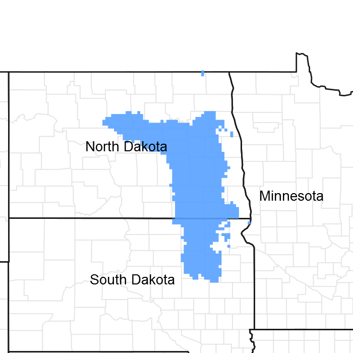
Figure 1. Mapped extent
Areas shown in blue indicate the maximum mapped extent of this ecological site. Other ecological sites likely occur within the highlighted areas. It is also possible for this ecological site to occur outside of highlighted areas if detailed soil survey has not been completed or recently updated.
MLRA notes
Major Land Resource Area (MLRA): 055B–Central Black Glaciated Plains
Central Black Glaciated Plains MLRA is an expansive and agriculturally important region consisting of more than 10,000,000 acres and including all or a portion of 27 counties in east-central and southeastern North Dakota and northeastern South Dakota.
Most of MLRA 55B is covered by till: material that was moved and redeposited by the glaciers. Pre-glaciated bedrock (shale) is exposed on the breaks to some of the valleys and incised drainageways; but what covers the bedrock is glacial sediment, known as drift. These areas have the Late Wisconsin age till plain integrated drainage system in contrast to the closed drainage of much of the till plain and moraines. Some soils, particularly along the Elm, James and Sheyenne rivers, have weathered shale beds in the substratum.
The Drift Prairie Region consists of nearly level to gently rolling glacial till plains dissected by glacial outwash channels. MLRA 55B is located within the boundaries of the Prairie Pothole Region with numerous wetlands in areas without integrated drainage systems. Seven rivers flow through parts of the MLRA. The James and Sheyenne Rivers both have their headwaters in the northern part of the MLRA. A relatively narrow, low range of hills separates these rivers creating a continental watershed divide. The James River flows generally southward through the MLRA and empties into the Missouri River beyond the MLRA border. The Sheyenne River flows to the south and to the east; it empties into the Red River of the North in MLRA 56A. Major tributaries to the James River are the Pipestem and Elm Rivers. The Sheyenne River receives additional water from Devils Lake (during periods of high lake levels) via two outlet pumping stations. Other important rivers in the MLRA are the Goose, Maple, and Wild Rice rivers which are also tributaries to the Red River of the North. The Wild Rice River begins in northeastern South Dakota and flows northward and eastward. In Sargent County, North Dakota, major ditch construction has served to straighten this river and more quickly drain water off adjacent farmland.
Surface and subsurface (tile) drainage systems have been constructed/installed in many areas to manage excess water and/or salinity on cropland. Soils that were poorly drained prior to wide-spread drainage may now function as somewhat poorly drained or moderately well drained soils. Restoration of hydrology to the natural conditions of the reference state may not be possible.
This region is utilized mostly by farms and ranches; about 75 percent is non-irrigated cropland. Cash-grain, bean and oil production crops are the principal enterprise on many farms, but other feed grains and hay are also grown. The vegetation on the steeper slopes, very stony areas, and thinner (or sandy) soils is still native rangeland. About 1 percent of this area is forested. Most forested areas occur along rivers, particularly the Sheyenne River Valley.
Classification relationships
Level IV Ecoregions of the Conterminous United States: 46c – Glacial Lake Basins; 46d – Glacial Lake Delta; 46e – Tewaukon Dead ice Moraine; 46f – End Moraine Complex; 46i – Drift Plains; and 46j – Glacial Outwash .
Ecological site concept
The Loamy ecological site typically is located on glaciated uplands – rises on ground moraines and lake plains; on back slopes on moraines; and on side slopes of escarpments. The site also occurs on flats on outwash plains and on terraces which are no longer impacted by frequent flooding. Generally, the soils are very deep; however, some have layers of sand and gravel or weathered shale in the substratum (>20 inches deep). The dark-colored surface soil is more than 7 inches thick. Surface textures typically are loam or silt loam; but clay loam, silty clay loam, and fine sandy loam also occur. The subsoil is loam, clay loam, silt loam, or silty clay loam (forms a ribbon 1 to 2 inches long). Soil on this site is moderately well drained or well drained. Very slight to slight effervescence is allowed. Depth to strong or violent effervescence exceeds 8 inches (commonly deeper than 12 inches). The central site concept is for soils with very slight or no salinity throughout the profile. However, slight salinity is allowable below a depth of 20 inches; where this occurs, it is most commonly in soils with a weakly developed claypan layer, soils with high amounts of shale in the parent material, or soils that are intermingled with saline or sodic soils (see Site Development and Testing Plan). Slopes range from 0 to 35 percent. On the landscape, this site is below the Thin Loamy and Shallow Loamy ecological sites and above the Loamy Overflow, Limy Subirrigated, Wet Meadow, and Subirrigated sites. The Clayey ecological site occurs on similar landscape positions; the subsoil forms a ribbon >2 inches long. The transition between Loamy and Thin Loamy sites is determined by depth to accumulated carbonates. Soils with strong or violent effervescence within a depth of 8 inches are included in Thin Loamy – even where a thin, non-calcareous subsoil layer occurs above the calcic layer.
To see a full copy of the ecological site description with all tables and the full version 5 rangeland health worksheet, please use the following hyperlink: https://efotg.sc.egov.usda.gov/references/public/ND/55B_Loamy_Narrative_FINAL_Ref_FSG.pdf
Associated sites
| R055BY058ND |
Limy Subirrigated This site occurs lower on the landscape. It is highly calcareous in the upper part of the subsoil and has redoximorphic features at a depth of 18 to 30 inches. All textures are included in this site. |
|---|---|
| R055BY068ND |
Thin Loamy This site occurs on higher, convex slopes on till plains and lake plains. It is highly calcareous (strong or violent effervescence) within a depth of 8 inches . The surface and subsoil layers form a ribbon 1 to 2 inches long. |
| R055BY071ND |
Wet Meadow Poorly drained soils in depressions and flats on uplands; it also occurs on floodplains. A seasonal water table is typically within a depth of 1.5 feet during the months of April through June; in depressions, it is frequently ponded (typically <1.5 feet) in April and May. Redoximorphic features, typically, are within a depth of 18 inches. Some soils are highly calcareous. E.C. is <8 dS/m in the surface and subsoil layers. All textures are included in this site. |
| R055BY056ND |
Clayey This site typically occurs somewhat lower on the landscape. The subsoil layer forms a ribbon >2 inches long. |
| R055BY073ND |
Shallow Loamy This site occurs on escarpments higher on the landscape. It has soft sedimentary shale bedrock within a depth of 20 inches. The soil above the shale forms a ribbon 1 to 2 inches long. |
| R055BY059ND |
Loamy Overflow This site occurs on lower, concave slopes on till plains and lake plains – a run-on position; it also occurs on frequently flooded floodplain steps and low terraces. The surface and subsoil layers form a ribbon 1 to 2 inches long. |
| R055BY065ND |
Subirrigated This site occurs on flats and in shallow depressions which have occasional, brief ponding early in the growing season. It has redoximorphic features at a depth of 18 to 30 inches. If present, a highly calcareous subsoil is >16 inches deep. All textures are included in this site. |
Similar sites
| R055BY059ND |
Loamy Overflow This site occurs on lower, concave slopes on till plains and lake plains – a run-on position; it also occurs on frequently flooded floodplain steps and low terraces. The surface and subsoil layers form a ribbon 1 to 2 inches long. |
|---|---|
| R055BY056ND |
Clayey This site typically occurs somewhat lower on the landscape. The subsoil layer forms a ribbon >2 inches long. |
| R055BY062ND |
Sandy This site occurs on till plains and lake plains that are mantled with fine sandy loam or sandy loam eolian deposits. The surface and subsoil layers from a ribbon <1 inch long. |
Table 1. Dominant plant species
| Tree |
Not specified |
|---|---|
| Shrub |
Not specified |
| Herbaceous |
(1) Pascopyrum smithii |
Physiographic features
This site typically occurs on glaciated uplands. Most commonly, it is on rises on ground moraines and lake plains; on back slopes on moraines; and on side slopes of escarpments. It also occurs on flats on outwash plains. On ground moraines and moraines, the parent material is either fine-loamy or coarse-loamy till. On lake plains, the parent material is fine-silty, coarse-silty, fine-loamy, or coarse-loamy glaciolacustrine sediments. On escarpments, the parent material is till or colluvium (at least 20 inches thick) over weathered shale. On outwash plains, the parent material is fine-loamy glaciofluvial deposits (at least 20 inches thick) over coarser glaciofluvial deposits. Included in this site are terraces which are no longer impacted by frequent flooding. Slopes range from 0 to 35 percent.
Table 2. Representative physiographic features
| Landforms |
(1)
Till plain
(2) Terrace (3) Lake plain (4) Escarpment (5) Outwash plain |
|---|---|
| Runoff class | Low to high |
| Flooding duration | Brief (2 to 7 days) |
| Flooding frequency | None to occasional |
| Ponding frequency | None |
| Elevation | 980 – 2,135 ft |
| Slope | 35% |
| Water table depth | 36 – 80 in |
| Aspect | Aspect is not a significant factor |
Climatic features
MLRA 55B is considered to have a continental climate – cold winters and hot summers, low humidity, light rainfall, and much sunshine. Extremes in temperature are characteristic of the MLRA. The climate is the result of this MLRA’s location in the geographic center of North America. There are few natural barriers on the northern Great Plains. The air masses move unobstructed across the plains and account for rapid changes in temperature.
Annual precipitation ranges from 18 to 23 inches per year. The normal average annual temperature is about 41.5° F. January is the coldest month with average low temperature ranging from about -4.3° F (Petersburg, ND) to about 2.5° F (Mellette, SD). July is the warmest month with temperatures averaging from about 79° F (Petersburg, ND) to about 84° F (Mellette, SD). The range of normal average monthly temperatures between the coldest and warmest months is about 64° F. This large annual range attests to the continental nature of this MLRA's climate. Winds average about 11 miles per hour annually, ranging from about 13 miles per hour during the spring to about 10 miles per hour during the summer. Daytime winds are generally stronger than nighttime and strong storms may bring brief periods of high winds with gusts to more than 50 miles per hour.
Growth of native cool-season plants begins in late March and continues to early to mid-July. Native warm- season plants begin growth in mid-May and continue to the end of August. Greening up of cool-season plants can occur in September and October when adequate soil moisture is present.
Table 3. Representative climatic features
| Frost-free period (characteristic range) | 111-117 days |
|---|---|
| Freeze-free period (characteristic range) | 128-134 days |
| Precipitation total (characteristic range) | 19-22 in |
| Frost-free period (actual range) | 105-119 days |
| Freeze-free period (actual range) | 124-135 days |
| Precipitation total (actual range) | 18-23 in |
| Frost-free period (average) | 114 days |
| Freeze-free period (average) | 131 days |
| Precipitation total (average) | 21 in |
Figure 2. Monthly precipitation range
Figure 3. Monthly minimum temperature range
Figure 4. Monthly maximum temperature range
Figure 5. Monthly average minimum and maximum temperature
Figure 6. Annual precipitation pattern
Figure 7. Annual average temperature pattern
Climate stations used
-
(1) BUTTE 5SE [USC00321225], Butte, ND
-
(2) CARRINGTON [USC00321360], Carrington, ND
-
(3) FORMAN 5 SSE [USC00323117], Forman, ND
-
(4) HARVEY 4NE [USC00324013], Harvey, ND
-
(5) LA MOURE [USC00324937], Lamoure, ND
-
(6) MELLETTE 4 W [USC00395456], Northville, SD
-
(7) PETERSBURG 2 N [USC00327027], Petersburg, ND
-
(8) COLUMBIA 8 N [USC00391873], Columbia, SD
Influencing water features
This site does not receive additional water as runoff from adjacent slopes (it is commonly on a run-off landscape position). Depth to the water table exceeds 3 feet in the spring and ranges from 4 feet to more than 6 feet during the summer months. Surface infiltration is moderately slow to moderate. Permeability through the profile, typically, is moderately slow to moderate; however, in soils with contrasting substratum materials, it is very rapid where gravelly and slow where weathered shale beds occur. Water loss is through evapotranspiration and percolation below the root zone. Where this site occurs on terraces, flooding frequency is none to occasional.
Soil features
Soils associated with Loamy ecological site are in the Mollisol order. The Mollisols are classified further as Calcic Argiudolls, Pachic Argiudolls, Calcic Hapludolls, Typic Hapludolls, Pachic Hapludolls, Oxyaquic Hapludolls, and Cumulic Hapludolls (>6% slope on uplands or on terraces). Glossic Natrudolls (<35% clay) are currently included in the Loamy site (see Site Development and Testing Plan). These soils were developed under prairie vegetation. The soils in this site commonly formed in till, glaciolacustrine sediments, or colluvium from till or residuum; a few formed in alluvium.
The common feature of soils in this site are the medium and moderately fine textures through most of the root zone. Surface textures most commonly are loam or silt loam; but clay loam and silty clay loam are included. Also, fine sandy loam is allowable where it is <10 inches thick. Most of these soils are very deep; however, some are moderately deep (20 to 40 inches) to layers of weathered shale or sand and gravel. They are moderately well drained or well drained. Where present, redoximorphic features are deeper than 3 feet.
Typically, soil salinity is none to very slight (E.C. <4 dS/m) and sodicity is none to low (SAR <5) to a depth >40 inches. However, in the included Glossic Natrudolls (Cathay and Camtown soils) E.C. and SAR values as high as 8 are allowable; these soils also have a weakly developed claypan layer.
Note: For Cathay or Camtown soils with moderate salinity and/or sodicity (E.C. and/or SAR >8) within a depth of 40 inches (gypsum accumulations should be visible), the Claypan ecological site should be considered.
Soil reaction is slightly acid to slightly alkaline (pH 6.1 to 7.8) in the surface layer and upper part of the subsoil. It commonly increases to moderately alkaline (pH 7.9 to 8.4) in the lower subsoil; this is most commonly due to a layer of calcium carbonate (CaCO3) accumulation, but it can also be due to increased sodicity. Where carbonate accumulation is present, this layer is typically below a depth of 12 inches and the layers above do not effervesce. In the layer of accumulation, CaCO3 content can be >30 percent below a depth of 20 inches. In a few soils, soil reaction may be strongly alkaline (pH 8.5 to 9.0) in the lower subsoil and substratum.
The soil surface is stable and intact. These soils are mainly susceptible to water erosion. The hazard of water erosion increases where vegetative cover is not adequate. Loss of the soil surface layer can result in a shift in species composition and/or production.
Major soil series correlated to the Loamy site are Aastad, Barnes, Cathay, Camtown, Darnen, Eckman, Edgeley, Emrick, Fordville, Forman, Gardena, Great Bend, Heimdal, Kensal, La Prairie (>6% slope), LaDelle (rarely flooded), Lankin, Overly, Rentill, Svea, Vang, Vida, and Walsh.
Access Web Soil Survey ( https://websoilsurvey.sc.egov.usda.gov/App/WebSoilSurvey.aspx ) for specific local soils information.
Table 4. Representative soil features
| Parent material |
(1)
Till
(2) Glaciolacustrine deposits (3) Colluvium (4) Alluvium (5) Loess (6) Lacustrine deposits (7) Residuum |
|---|---|
| Surface texture |
(1) Loam (2) Stony, cobbly, very stony loam (3) Extremely stony, bouldery loam (4) Silt loam (5) Stony, cobbly, very stony silt loam (6) Extremely stony, bouldery silt loam (7) Silty clay loam (8) Stony, cobbly, very stony silty clay loam (9) Extremely stony, bouldery silty clay loam (10) Clay loam (11) Stony, cobbly, very stony clay loam (12) Extremely stony, bouldery clay loam |
| Family particle size |
(1) Loamy |
| Drainage class | Moderately well drained to well drained |
| Permeability class | Moderately slow to moderate |
| Depth to restrictive layer | 20 – 80 in |
| Surface fragment cover <=3" | 15% |
| Surface fragment cover >3" | 18% |
| Available water capacity (0-40in) |
6 – 12 in |
| Calcium carbonate equivalent (0-40in) |
30% |
| Electrical conductivity (0-20in) |
4 mmhos/cm |
| Sodium adsorption ratio (0-20in) |
5 |
| Soil reaction (1:1 water) (0-20in) |
6.1 – 8.4 |
| Subsurface fragment volume <=3" (Depth not specified) |
15% |
| Subsurface fragment volume >3" (Depth not specified) |
25% |
Ecological dynamics
This ecological site description is based on nonequilibrium ecology and resilience theory and utilizes a State- and-Transition Model (STM) diagram to organize and communicate information about ecosystem change as a basis for management. The ecological dynamics characterized by the STM diagram reflect how changes in ecological drivers, feedback mechanisms, and controlling variables can maintain or induce changes in plant community composition (phases and/or states). The application of various management actions, combined with weather variables, impact the ecological processes which influence the competitive interactions, thereby maintaining or altering plant community structure.
Prior to European influence, the historical disturbance regime for MLRA 55B included frequent fires, both anthropogenic and natural in origin. Most fires, however, were anthropogenic fires set by Native Americans. Native Americans set fires in all months except perhaps January. These fires occurred in two peak periods, one from March-May with the peak in April and another from July-November with the peak occurring in October. Most of these fires were scattered and of small extent and duration. The grazing history would have involved grazing and browsing by large herbivores (such as American bison, elk, and whitetail deer). Herbivory by small mammals, insects, nematodes, and other invertebrates are also important factors influencing the production and composition of the communities. Grazing and fire interaction, particularly when coupled with drought events, influenced the dynamics discussed and displayed in the following state and transition diagram and descriptions.
Following European influence, this ecological site generally has had a history of grazing by domestic livestock, particularly cattle, which along with other related activities (e.g., fencing, water development, fire suppression) has changed the disturbance regime of the site. Changes will occur in the plant communities due to these and other factors.
Weather fluctuations coupled with managerial factors may lead to changes in the plant communities and may, under adverse impacts, result in a slow decline in vegetative vigor and composition. However, under favorable conditions the botanical composition may resemble that prior to European influence.
Five vegetative states have been identified for the site (Reference, Native/Invaded, Invaded, Invaded Wooded, and Go-Back). Within each state, one or more community phases have been identified. These community phases are named based on the more dominant and visually conspicuous species; they have been determined by study of historical documents, relict areas, scientific studies, and ecological aspects of plant species and plant communities. Transitional pathways and thresholds have been determined through similar methods.
State 1: Reference State represents the natural range of variability that dominated the dynamics of this ecological site prior to European influence. Dynamics of the state were largely determined by variations in climate and weather (e.g., drought), as well as that of fire (e.g., timing, frequency) and grazing by native herbivores (e.g., frequency, intensity, selectivity). Due to those variations, the Reference State is thought to have shifted temporally and spatially between two plant community phases.
Currently the primary disturbances include widespread introduction of exotic plants, concentrated livestock grazing, lack of fire, and perhaps long-term non-use and no fire. Because of these changes, particularly the widespread occurrence of exotic plants, as well as other environmental changes, the Reference State is considered to no longer exist. Thus, the presence of exotic plants on the site precludes it from being placed in the Reference State. It must then be placed in one of the other states, commonly State 2: Native/Invaded State (T1A).
State 2: Native/Invaded State. Colonization of the site by exotic plants results in a transition from State 1: Reference State to State 2: Native/Invaded State (T1A). This transition was inevitable; it often resulted from colonization by exotic cool-season grasses (e.g., Kentucky bluegrass, smooth brome, quackgrass) which have been particularly and consistently invasive under extended periods of non-use and no fire. Other exotics (e.g., Canada thistle, leafy spurge) are also known to invade the site.
Three community phases have been identified for this state; they are similar to the community phases in the Reference State but have now been invaded by exotic cool-season grasses. These exotic cool-season grasses can be expected to increase. As that increase occurs, plants more desirable to wildlife and livestock may decline. A decline in forb diversity can also be expected. Under non-use or minimal use management, mulch increases and may become a physical barrier to plant growth. This also changes the micro-climate near the soil surface and may alter Infiltration, nutrient cycling, and biological activity near the soil surface. As a result, these factors coupled with shading cause desirable native plants to have increasing difficulty remaining viable and recruitment declines.
To slow or limit the invasion of these exotic grasses or other exotic plants, it is imperative that managerial techniques (e.g., prescribed grazing, prescribed burning) be carefully constructed, monitored, and evaluated with respect to that objective. If management does not include measures to control or reduce these exotic plants, the transition to State 3: Invaded State should be expected (T2A). This state may also transition to State 5: Invaded Wooded State from Community Phase 2.3 during long-term non-use or very light grazing, and no fire (T2B).
State 3: Invaded State. The threshold for this state is reached when both the exotic cool-season grasses (e.g., Kentucky bluegrass, smooth brome, quackgrass) exceed 30% of the plant community and native grasses represent less than 40% of the community. One community phase has been identified for this state.
The exotic cool-season grasses can be quite invasive and often form monotypic stands. As they increase, both forage quantity and quality of the annual production becomes increasingly restricted to late spring and early summer, even though annual production may increase. Forb diversity often declines. Under non-use or minimal use management, mulch can increase and become a physical barrier to plant growth which alters nutrient cycling, infiltration, and soil biological activity. As such, desirable native plants become increasingly displaced.
Once the state is well established, prescribed burning and prescribed grazing techniques have been largely ineffective in suppressing or eliminating the exotic cool-season grasses, even though some short-term reductions may appear successful. However, assuming there is an adequate component of native grasses to respond to treatments, a restoration pathway to State 2: Native/Invaded State may be accomplished with the implementation of long-term prescribed grazing in conjunction with prescribed burning (R3A). This state may also transition to State 5: Invaded Wooded State during long-term non-use or very light grazing, and no fire (T3A).
State 4: Go-Back State often results following cropland abandonment and consists of one plant community phase. This weedy assemblage may include noxious weeds that need control. Over time, the exotic cool- season grasses (e.g., Kentucky bluegrass, smooth brome, quackgrass) will likely predominate.
Initially, due to extensive bare ground and a preponderance of shallow rooted annual plants the potential for soil erosion is high. Plant species richness may be high, but overall diversity (i.e., equitability) is typically low, with the site dominated by a relatively small assemblage of species. Due to the lack of native perennials and other factors, restoring the site with the associated ecological processes is difficult. However, a successful range planting may result in something approaching State 2: Native/Invaded State (R4A). Following seeding, prescribed grazing, prescribed burning, haying, and the use of herbicides will generally be necessary to achieve the desired result and control weeds, some of which may be noxious weeds. A failed range planting and/or secondary succession will lead to State 4: Invaded State (R4B). Long-term non-use and no disturbances will lead to State 5: Invaded Wooded State (T4A).
State 5: Invaded Wooded State
Woody vegetation historically existed as small patches of trees and/or shrubs scattered across the site when precipitation, fire frequency, and other factors enabled woody species to colonize or encroach on the site. It often resulted in a mosaic of patches of woody vegetation interspersed within the grass dominated vegetation. However, it has now been invaded by exotic cool-season grasses (e.g., Kentucky bluegrass, smooth brome, quackgrass). A marked increase in non-use management and active fire suppression since European influence has enabled this state to expand and become more widespread. One community phase has been identified and often result from long-term non-use or very light grazing, and no fire (T2B, T3A). Prescribed burning and/or chemical/mechanical brush management may lead to State 2: Native/Invaded State (R5A) or State 3: Invaded State (R5B) depending upon the abundance of exotic cool-season grasses. A follow-up successful range planting may be necessary to complete the restoration to State 2: Native/Invaded State.
Woody Invasion. Historically, individual (or small patches of) shrubs and/or trees were scattered across the site. However, a marked increase in fire suppression, climate change, increase in non-use, and other factors enabled woody species to colonize, form patches (resistant to fire), and begin to or encroach on the site.
These changes have enabled these patches to expand and become more widespread. Encroachment of both native and exotic woody species (e.g., Rocky Mountain juniper, Russian olive, Siberian elm, western snowberry, silverberry, ponderosa. pine, eastern red cedar, etc.) are examples of woody vegetation increasing in extent and impinging on the ecological integrity of the grassland biome. Windbreaks and other tree plantings can contain problematic and invasive species (such as eastern redcedar, Rocky Mountain juniper, ponderosa pine, Russian olive, etc.), which can contaminate surrounding grasslands. This results in increased long-term costs to maintain or restore this ecological site in native grasses and forbs.
The following state and transition model diagram illustrates the common states, community phases, community pathways, and transition and restoration pathways that can occur on the site. These are the most common plant community phases and states based on current knowledge and experience; changes may be made as more data are collected. Pathway narratives describing the site’s ecological dynamics reference various management practices (e.g., prescribed grazing, prescribed fire, brush management, herbaceous weed treatment) which, if properly designed and implemented, will positively influence plant community competitive interactions. The design of these management practices will be site specific and should be developed by knowledgeable individuals; based upon management goals and a resource inventory; and supported by an ongoing monitoring protocol.
When the management goal is to maintain an existing plant community phase or restore to another phase within the same state, modification of existing management to ensure native species have the competitive advantage may be required. To restore a previous state, the application of two or more management practices in an ongoing manner will be required. Whether using prescribed grazing, prescribed burning, or a combination of both with or without additional practices (e.g., brush management), the timing and method of application needs to favor the native species over the exotic species. Adjustments to account for variations in annual growing conditions and implementing an ongoing monitoring protocol to track changes and adjust management inputs to ensure desired outcome will be necessary.
The plant community phase composition table(s) has been developed from the best available knowledge including research, historical records, clipping studies, and inventory records. As more data are collected, plant community species composition and production information may be revised.
State and transition model
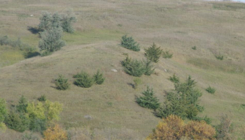
Figure 8. Regardless of specific ecological site, eastern red cedar and Russian olive invasion on native rangeland in a formerly treeless grassland biome in MLRA 55B. Eastern red cedar and Russian olive seed source likely translocated by birds

More interactive model formats are also available.
View Interactive Models
More interactive model formats are also available.
View Interactive Models
Click on state and transition labels to scroll to the respective text
Ecosystem states
States 2 and 5 (additional transitions)
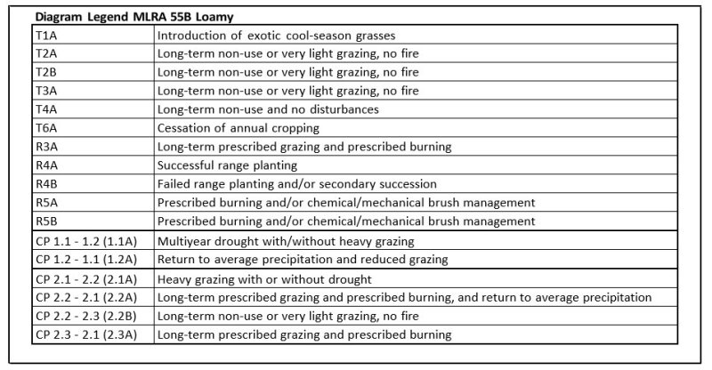
| T1A | - | Introduction of exotic cool season grasses |
|---|---|---|
| T2A | - | Long term non-use or very light grazing, no fire |
| T2B | - | Long term non-use or very light grazing, no fire |
| R3A | - | Long term prescribed grazing and prescribed burning |
| T3A | - | Long term non-use or very light grazing, no fire |
| R4A | - | Successful range planting |
| R4B | - | Failed range planting and/or secondary succession |
| T4A | - | Long term non-use and no disturbances |
| R5A | - | Prescribed burning and/or chemical/mechanical brush management |
| R5B | - | Prescribed burning and/or chemical/mechanical brush management |
| T6A | - | Cessation of annual cropping |
State 1 submodel, plant communities
| 1.1a | - | Multiyear drought with/without heavy grazing |
|---|---|---|
| 1.2a | - | Return to average precipitation and reduced grazing |
State 2 submodel, plant communities
| 2.1a | - | Heavy grazing with or without drought |
|---|---|---|
| 2.2a | - | Long term prescribed grazing and prescribed burning, and return to average precipitation |
| 2.2b | - | Long term non-use or very light grazing, no fire |
| 2.3a | - | Long term prescribed grazing and prescribed burning |
State 3 submodel, plant communities
State 4 submodel, plant communities
State 5 submodel, plant communities
State 1
Reference
This state represents the natural range of variability that dominated the dynamics of this ecological site prior to European influence. The primary disturbance mechanisms for this site in the reference condition included frequent fire and grazing by large herding ungulates. Timing of fires and grazing, coupled with weather events, dictated the dynamics that occurred within the natural range of variability. These factors likely caused the community to shift both spatially and temporally between two community phases.
Characteristics and indicators. Because of changes in disturbances and other environmental factors (particularly the widespread occurrence of exotic species), the Reference State is considered to no longer exist.
Resilience management. If intact, the reference state should probably be managed with current disturbance regimes which has permitted the site to remain in reference condition as well as maintaining the quality and integrity of associated ecological sites. Maintenance of the reference condition is contingent upon a monitoring protocol to guide management.
Community 1.1
Green Needlegrass-Western Wheatgrass (Nassella viridula- Pascopyrum smithii)
This community phase was historically the most dominant both temporally and spatially. Cool-season grass and grass-like species dominated this plant community with warm-season grasses being subdominant. The major grasses included green needlegrass, western wheatgrass, needle and thread, porcupinegrass, and slender wheatgrass. Big bluestem and blue grama were the major warm-season grasses. Common forbs included white sagebrush, wavyleaf thistle, purple prairie clover, and stiff sunflower. Western snowberry and leadplant were the major shrubs. Annual production varied from about 1600-3600 pounds per acre with grasses and grass-likes, forbs, and shrubs contributing about 85%, 10% and 5%, respectively. This community represents the plant community phase upon which interpretations are primarily based and is described in the “Plant Community Composition and Group Annual Production” portion of this ecological site description.
Figure 9. Annual production by plant type (representative values) or group (midpoint values)
Table 5. Annual production by plant type
| Plant type | Low (lb/acre) |
Representative value (lb/acre) |
High (lb/acre) |
|---|---|---|---|
| Grass/Grasslike | 1440 | 2506 | 3155 |
| Forb | 135 | 210 | 300 |
| Shrub/Vine | 25 | 84 | 145 |
| Total | 1600 | 2800 | 3600 |
Figure 10. Plant community growth curve (percent production by month). ND5501, Central Black Glaciated Plains, cool-season dominant. Cool-season dominant..
| Jan | Feb | Mar | Apr | May | Jun | Jul | Aug | Sep | Oct | Nov | Dec |
|---|---|---|---|---|---|---|---|---|---|---|---|
| J | F | M | A | M | J | J | A | S | O | N | D |
| 0 | 0 | 3 | 8 | 24 | 45 | 10 | 3 | 5 | 2 | 0 | 0 |
Community 1.2
Western Wheatgrass-Needle and Thread-Blue Grama (Pascypyrum smithii-Hesperostipa comata-Bouteloua gracilis)
This community phase formed during multiyear drought with or without heavy grazing. Blue grama and needle and thread increased markedly while green needlegrass and other less drought/grazing tolerant grasses decreased. Forbs and shrubs (such as common yarrow, silverleaf Indian breadroot, white heath aster, and prairie sagewort) had increased compared to community phase 1.1.
Pathway 1.1a
Community 1.1 to 1.2
Community Phase Pathway 1.1 to 1.2 occurred during long-term drought with or without heavy grazing leading to marked increases in blue grama and needle and thread along with a corresponding decrease in green needlegrass.
Pathway 1.2a
Community 1.2 to 1.1
Community Phase Pathway 1.2 to 1.1 occurred with the return to average precipitation and reduced grazing, leading to marked decreases in blue grama and needle and thread along with a corresponding increase in green needlegrass.
State 2
Native/Invaded
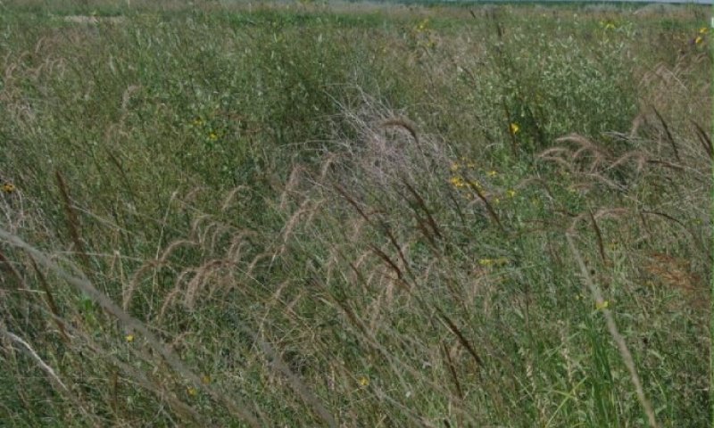
Figure 11. Restoration Pathway R4A – Successful range planting with multiple species planting.
This state is similar to State 1: Reference State but has now been colonized by the exotic cool-season grasses (e.g., Kentucky bluegrass, smooth brome, quackgrass) which are now present in small amounts. Although the state is still dominated by native grasses, an increase in these exotic cool-season grasses can be expected. These exotic cool-season grasses can be quite invasive on the site and are particularly well adapted to heavy grazing. They also often form monotypic stands. As these exotic cool-season grasses increase, both forage quantity and quality become increasingly restricted to late spring and early summer due to the monotypic nature of the stand, even though annual production may increase. Native forbs generally decrease in production, abundance, diversity, and richness compared to that of State 1: Reference State. These exotic cool-season grasses have been particularly and consistently invasive under extended periods of non-use and no fire. To slow or limit the invasion of these exotic grasses, it is imperative that managerial techniques (e.g., prescribed grazing, prescribed burning) be carefully constructed, monitored, and evaluated with respect to that objective. If management does not include measures to control or reduce these exotic cool-season grasses, the transition to State 3: Invaded State should be expected. Annual production of this state can be quite variable, in large part due to the amount of exotic cool-season grasses. However, as the exotic cool-season grasses increase, peak production will shift to earlier in the growing season.
Characteristics and indicators. The presence of trace amounts of exotic cool-season grasses indicates a transition from State 1 to State 2. The presence of exotic biennial or perennial leguminous forbs (i.e., sweet clover, black medic) may not, on their own, indicate a transition from State 1 to State 2 but may facilitate that transition.
Resilience management. To slow or limit the invasion of these exotic grasses, it is imperative that managerial techniques (e.g., prescribed grazing, prescribed burning) be carefully constructed, monitored, and evaluated with respect to that objective. Grazing management should be applied that enhances the competitive advantage of native grass and forb species. This may include: (1) grazing when exotic cool-season grasses are actively growing and native cool- season grasses are dormant; (2) applying proper deferment periods allowing native grasses to recover and maintain or improve vigor; (3) adjusting overall grazing intensity to reduce excessive plant litter (above that needed for rangeland health indicator #14 – see Rangeland Health Reference Worksheet); (4) incorporating early heavy spring utilization which focuses grazing pressure on exotic cool-season grasses and reduces plant litter, provided that livestock are moved when grazing selection shifts from exotic cool-season grasses to native grasses. Prescribed burning should be applied in a manner that maintains or enhances the competitive advantage of native grass and forb species. Prescribed burns should be applied as needed to adequately reduce/remove excessive plant litter and maintain the competitive advantage for native species. Timing of prescribed burns (spring vs. summer vs. fall) should be adjusted to account for differences in annual growing conditions and applied during windows of opportunity to best shift the competitive advantage to the native species.
Community 2.1
Green Needlegrass-Western Wheatgrass (Nassella viridula- Pascopyrum smithii)
This community phase is similar to Community Phase 1.1 but has been colonized by exotic cool-season grasses (e.g., Kentucky bluegrass, smooth brome, quackgrass). However, these exotics are present in smaller amounts with the community still dominated by native grasses. Annual production may be comparable to that of Community Phase 1.1 (1600-3600 pounds per acre). However, as the exotic cool-season grasses increase, peak production will shift to earlier in the growing season.
Community 2.2
Blue Grama/ Sedges/ Exotic Cool Season Grasses (Bouteloua gracilis/ Carex spp./ Exotic Cool-Season Grasses)
This community phase is similar to Community Phase 1.2 but has now been colonized by exotic cool-season grasses (e.g., Kentucky bluegrass, smooth brome, quackgrass). These exotics, however, are present in smaller amounts with the community still dominated by native grasses. This community phase is often dispersed throughout a pasture in an overgrazed/ undergrazed pattern, typically referred to as patch grazing. Some overgrazed areas will exhibit the impacts of heavy use, while the ungrazed areas will have a build-up of litter and increased plant decadence. This is a typical pattern found in properly stocked pastures grazed season-long. As a result, Kentucky bluegrass tends to increase more in the undergrazed areas while the more grazing tolerant short-statured species, such as blue grama and sedges, increase in the heavily grazed areas. If present, Kentucky bluegrass may increase under heavy grazing. Increasing amounts of exotic cool-season grasses, particularly Kentucky bluegrass, can make this an “at risk” community even though its presence may not be obvious. If management does not include measures to control or reduce Kentucky bluegrass, the transition to State 3: Invaded State should be expected.
Community 2.3
Shrubs/Forbs/Exotic Cool Season Grasses
Long-term non-use or very light grazing, and no fire, leads to increases in shrubs, forbs, and exotic cool- season grasses. Western snowberry, prairie rose, silverleaf Indian breadroot, common yarrow, and white sagebrush are often among the more common shrubs and forbs. Exotic cool-season grasses often include Kentucky bluegrass, smooth brome, and/or quackgrass. This community phase is approaching the threshold leading to a transition to State 5: Invaded Wooded State, particularly when near trees that can serve as seed sources for colonization. As a result, it is an “at risk” community. If management does not include measures to control or reduce woody vegetation and the exotic cool-season grasses, a transition to State 5: Invaded Wooded State can be expected.
Pathway 2.1a
Community 2.1 to 2.2
Community Phase Pathway 2.1 to 2.2 occurs with heavy grazing with or without drought, leading to marked increases in blue grama, needle and thread, and exotic cool-season grasses along with a corresponding decrease in green needlegrass.
Pathway 2.2a
Community 2.2 to 2.1
Community Phase Pathway 2.2 to 2.1 occurs with the implementation of long-term prescribe grazing and prescribe burning and return to average precipitation. This leads to an increase in green needlegrass and corresponding decreases in blue grama, needle and thread, and exotic cool-season grasses.
Pathway 2.2b
Community 2.2 to 2.3
Community Phase Pathway 2.2 to 2.3 occurs with long-term non-use or very light grazing, and no fire. This leads to marked increases in shrubs, forbs, and exotic cool-season grasses.
Pathway 2.3a
Community 2.3 to 2.1
Community Phase Pathway 2.3 to 2.1 occurs with the implementation of long-term prescribed grazing and prescribed burning leading to decreases in shrubs, forbs, and exotic cool-season grasses with corresponding increases in green needlegrass, western wheatgrass, and other native plants.
State 3
Invaded
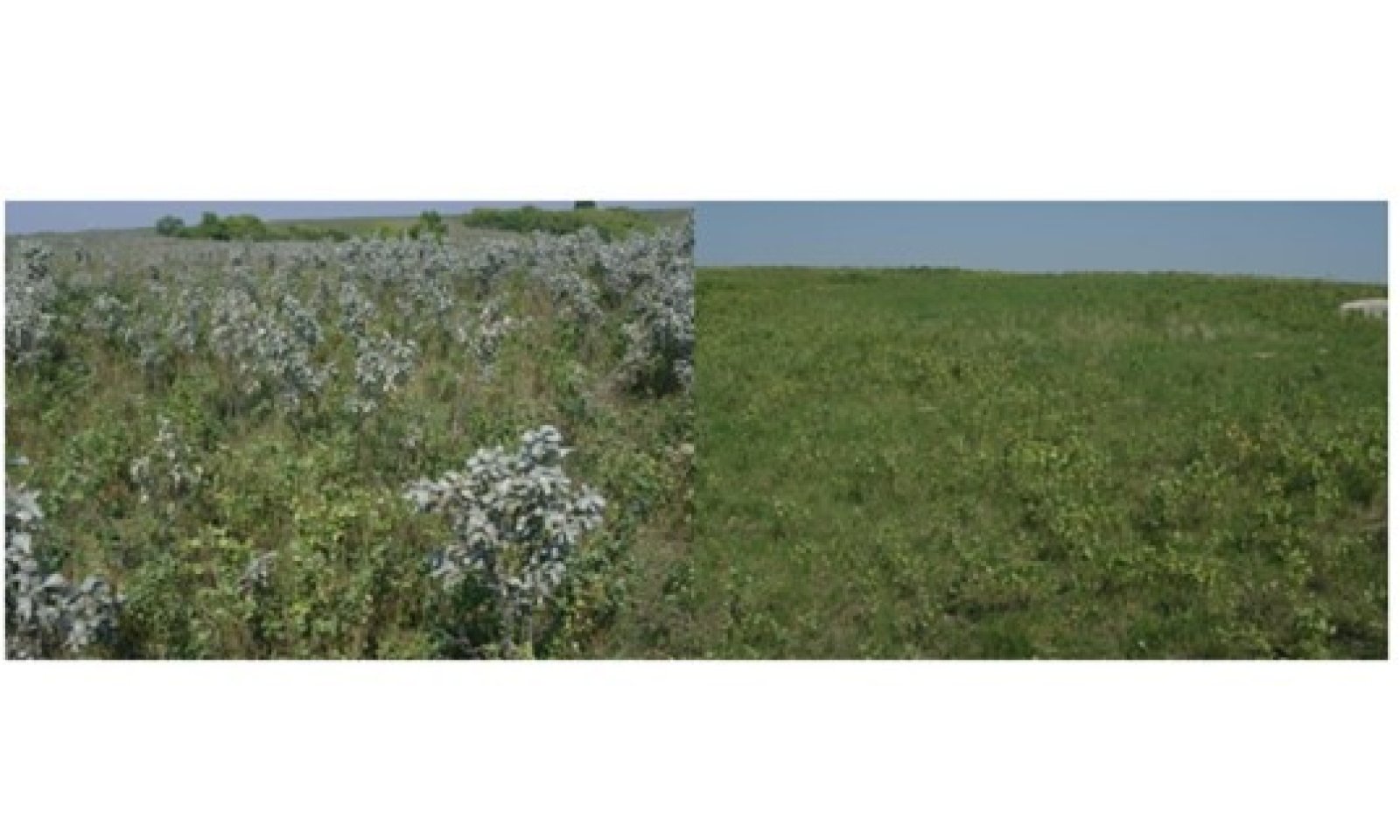
Figure 12. Restoration Pathway R4B–Dominated by Kentucky bluegrass, brome grass and western snowberry.
This state is the result of invasion and dominance by the exotic cool-season grasses (e.g., Kentucky bluegrass, smooth brome, quackgrass). Other exotic plants (e.g., leafy spurge) may also invade the site. These exotic cool-season grasses can be quite invasive on the site and are particularly well adapted to heavy grazing. They also often form monotypic stands. As these exotic cool-season grasses increase, both forage quantity and quality become increasingly restricted to late spring and early summer due to the monotypic nature of the stand, even though annual production may increase. Native forbs generally decrease in production, abundance, diversity, and richness compared to that of State 1: Reference State. Common forbs often include white heath aster, goldenrod, common yarrow, and white sagebrush. Shrubs, such as western snowberry and rose, may show marked increases. Once the state is well established, prescribed burning and grazing techniques have been largely ineffective in suppressing or eliminating these species, even though some short- term reductions may appear successful. Annual production of this state may vary widely, in part due to variations in the extent of invasion by exotic cool-season grasses. However, as the exotic cool-season grasses increase peak production will shift to earlier in the growing season.
Characteristics and indicators. This site is characterized by exotic cool-season grasses constituting greater than 30 percent of the annual production and native grasses constituting less than 40 percent of the annual production.
Resilience management. Light or moderately stocked continuous, season-long grazing or a prescribed grazing system which incorporates adequate deferment periods between grazing events and proper stocking rate levels will maintain this State. Application of herbaceous weed treatment, occasional prescribed burning and/or brush management may be needed to manage noxious weeds and increasing shrub (e.g., western snowberry) populations.
Community 3.1
Exotic Cool Season Grasses/Shrubs
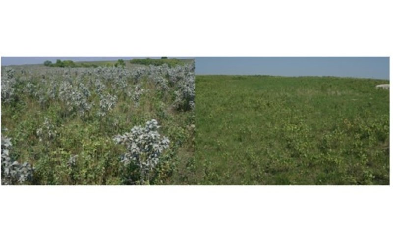
Figure 13. Community Phase 3.1: Exotic Cool-Season Grasses/Shrubs – Left dominated by Kentucky bluegrass and silverberry; Right dominated by Kentucky bluegrass and western snowberry.
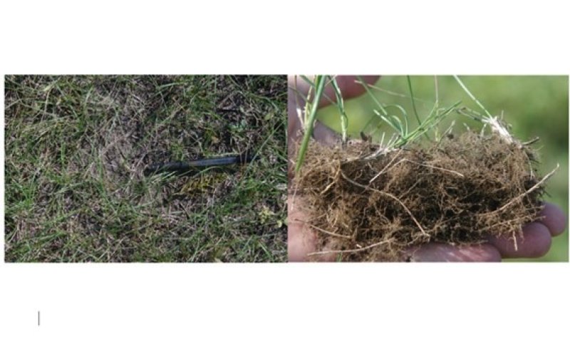
Figure 14. Community Phase 3.1: Exotic Cool-Season Grasses/Shrubs, dominated by Kentucky bluegrass. Note apparent bare ground in photo on left. Bare ground is actually accumulated Kentucky bluegrass root mass, approximately 1 inch thick.
This community phase is dominated by exotic cool-season grasses (e.g., Kentucky bluegrass, smooth brome, quackgrass), often in association with shrubs. Excessive accumulation of mulch may also be present, particularly when dominated by Kentucky bluegrass. Common forbs and shrubs often include western snowberry, prairie rose, silverleaf Indian breadroot, common yarrow, and white sagebrush. Other exotic plants (e.g., leafy spurge) may also invade the site. The longer this community phase exists, the more resilient it becomes. Natural or management disturbances that reduce the cover of Kentucky bluegrass or smooth brome are typically short-lived.
State 4
Go-Back
This state is highly variable depending on the level and duration of disturbance related to the T6A transitional pathway. In this MLRA, the most probable origin of this state is plant succession following cropland abandonment. This plant community will initially include a variety of annual forbs and grasses, some of which may be noxious weeds and need control. Over time, the exotic cool-season grasses (e.g., Kentucky bluegrass, smooth brome, quackgrass) will likely predominate.
Characteristics and indicators. Tillage has destroyed the native plant community, altered soil structure and biology, reduced soil organic matter, and resulted in the formation of a tillage induced compacted layer which is restrictive to root growth. Removal of perennial grasses and forbs results in decreased infiltration and increased runoff.
Resilience management. Continued tillage will maintain the state. Control of noxious weeds will be required.
Community 4.1
Annual/Pioneer Perennial/Exotics
This community phase is highly variable depending on the level and duration of disturbance related to the T6A transitional pathway. In this MLRA, the most probable origin of this phase is secondary succession following cropland abandonment. This plant community will initially include a variety of annual forbs and grasses, including noxious weeds (e.g., Canada thistle) which may need control. Over time, the exotic cool-season grasses (e.g., Kentucky bluegrass, smooth brome, quackgrass) will likely predominate.
State 5
Invaded Wooded
Woody vegetation historically existed as small patches of trees and/or shrubs scattered across the site, particularly where nearby trees and shrubs could have encroached onto the site vegetatively (e.g., rhizomes, root sprouts) or provided a seed source for colonization of the site. Variations in fire frequency enabled woody plant species in some areas (i.e., period of infrequent fire) to grow large enough to escape the next fire event. As trees increased in size, canopy cover increased which altered micro-climate and reduced fine fuel amounts resulting in reduced fire intensity and frequency. This would have been the primary pathway under the historic disturbance regime and would have resulted in a mosaic pattern of small, wooded patches interspersed within herbaceous plant community phases. A marked increase in non-use management and active fire suppression since European influence has enabled this state to expand and become more widespread. Subsequent colonization of these wooded stands by exotic cool-season grasses (e.g., Kentucky bluegrass, smooth brome, quackgrass) led to the establishment of the Invaded Wooded State. Common woody species often include green ash, bur oak, hawthorn, chokecherry, western snowberry, American plum, and wild rose. Buckthorn is increasing in MLRA 55B and can become invasive in this plant community. Kentucky bluegrass and smooth brome are the major exotic cool-season grasses. The forb component can be quite variable, and exotic forbs (e.g., leafy spurge, Canada thistle) are also known to invade the site.
Characteristics and indicators. The dominance of woody species (by cover and production) distinguishes this state from other herbaceously dominated states.
Resilience management. This state is resistant to change in the long-term absence of fire. Restoration efforts would require the use of prescribed fire, mechanical treatment, and prescribed grazing. Considerable time and effort will be required to restore to other States.
Community 5.1
Hardwood Trees/Shrubs
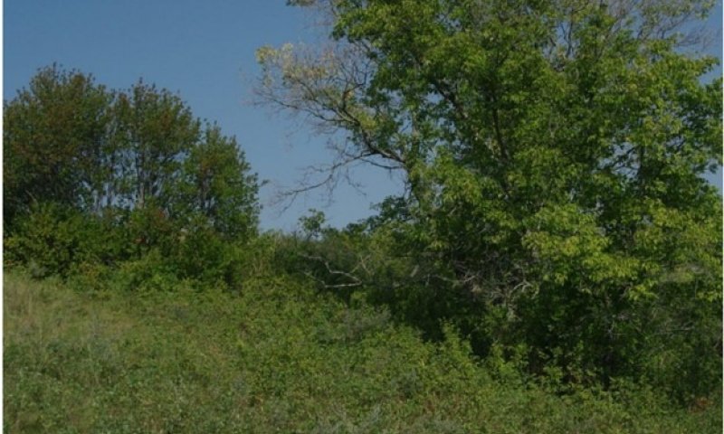
Figure 15. Community Phase 5.1 - Hardwood Trees/Shrubs dominated by chokecherry western snowberry and boxelder. Even with periodic prescribed burning, wooded invasion can occur or is difficult to control once established.
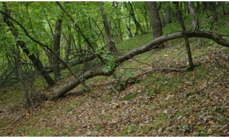
Figure 16. Community Phase 5.1 - Hardwood Trees/Shrubs dominated by green ash, oak, and basswood. Note: park-like appearance due to shading from closed canopy.
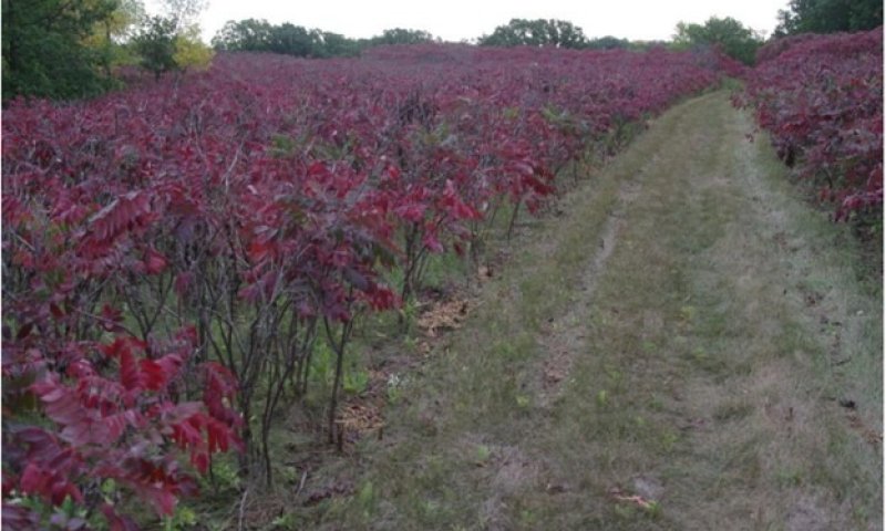
Figure 17. Community Phase 5.1 - Hardwood Trees/Shrubs dominated by smooth sumac changing growing conditions facilitating woody invasion.
This plant community phase is often characterized by green ash, bur oak, boxelder, and chokecherry. Other shrubs may include American plum, western snowberry, and hawthorn. An herbaceous understory of sedges, wildrye, and assorted forbs may also be present. Regardless of how this community phase originated, the exotic cool-season grasses (Kentucky bluegrass, smooth brome, and/or quackgrass) will generally be prominent components. As the trees mature and canopy cover increases, herbaceous production declines and shrubs/vines associated with mature woodlands may begin to occupy the understory.
State 6
Any Plant Community
Transition T1A
State 1 to 2
This is the transition from the State 1: Reference State to the State 2: Native/Invaded State due to the introduction and establishment of exotic cool-season grasses (e.g., Kentucky bluegrass, smooth brome, quackgrass). This transition was inevitable and corresponded to a decline in native warm-season and cool- season grasses; it may have been exacerbated by chronic season-long or heavy late season grazing. Complete rest from grazing and suppression of fire could also have hastened the transition. The threshold between states was crossed when Kentucky bluegrass, smooth brome, quackgrass, or other exotic species became established on the site.
Constraints to recovery. Current knowledge and technology will not facilitate a successful restoration to Reference State.
Transition T2A
State 2 to 3
This transition from the State 2: Native/Invaded State to State 3: Invaded State generally occurs with long-term non-use or very light grazing, and no fire. Exotic cool-season grasses (e.g., Kentucky bluegrass, smooth brome, quackgrass) become the dominant graminoids. Studies indicate that a threshold may exist in this transition when both the exotic cool-season grasses exceed 30% of the plant community and native grasses represent less than 40% of the plant community composition. This transition may occur under other managerial conditions, for example heavy season-long grazing (primarily Kentucky bluegrass).
Constraints to recovery. Variations in growing conditions (e.g., cool, wet spring) will influence effects of various management activities on exotic cool-season grass populations.
Transition T2B
State 2 to 5
This transition from State 2: Native/Invaded State to State 5: Invaded Wooded State occurs with long-term non-use or very light grazing, and no fire, particularly when near trees that can serve as seed sources for colonization. A marked increase in non-use management and active fire suppression since European influence has enabled this state to expand and become more widespread. In many cases this transition comes directly from Community Phase 2.3 (Shrubs/Forbs/Exotic Cool-Season Grasses).
Constraints to recovery. The extended fire interval may make recovery doubtful due to the abundance of exotic cool-season grasses and lack of native grasses. Fire intensity along with consumption of available fuels may cause incomplete or patchy burns. Continued recruitment of tree seeds from adjacent sites will hamper site restoration. Reticence to undertake tree removal and the perception that trees may be a desirable vegetation component for wildlife habitat, carbon sequestration, aesthetics, etc. are some of the constraints to recovery. Managers wanting to manage the site for deer, livestock, or grassland nesting birds will need to consider the intensive management required to restore and maintain the site in State 2. The disturbance regime necessary to restore this site to State 2: Native/Invaded State is very labor intensive and costly; therefore, addressing woody removal earlier in the encroachment phase is the most cost-effective treatment for woody control.
Restoration pathway R3A
State 3 to 2
This restoration pathway from State 3: Invaded State to State 2: Native/Invaded State may be accomplished with the implementation of long-term prescribed grazing and prescribed burning, assuming there is an adequate component of native grasses to respond to the treatments. Both prescribed grazing and prescribed burning are likely necessary to successfully initiate this restoration pathway, the success of which depends upon the presence of a remnant population of native grasses in Community Phase 3.1. That remnant population, however, may not be readily apparent without close inspection. The application of several prescribed burns may be needed at relatively short intervals in the early phases of this restoration process, in part because many of the shrubs (e.g., western snowberry) sprout profusely following one burn. Early season prescribed burns have been successful; however, fall burning may also be an effective technique. The prescribed grazing should include adequate recovery periods following each grazing event and stocking levels which match the available resources. If properly implemented, this will shift the competitive advantage from the exotic cool-season grasses to the native cool-season grasses.
Context dependence. Grazing management should be applied in a manner that enhances/maximizes the competitive advantage of native grass and forb species over the exotic species. This may include the use of prescribed grazing to reduce excessive plant litter accumulations above that needed for rangeland health indicator #14 (see Rangeland Health Reference Worksheet). Increasing livestock densities may facilitate the reduction in plant litter provided length and timing of grazing periods are adjusted to favor native species. Grazing prescriptions designed to address exotic grass invasion and favor native species may involve earlier, short, intense grazing periods with proper deferment to improve native species health and vigor. Fall (e.g., September, October) prescribed burning followed by an intensive, early spring graze period with adequate deferment for native grass recovery may shift the competitive advantage to the native species, facilitating the restoration to State 2: Native/Invaded. Prescribed burning should be applied in a manner that enhances the competitive advantage of native grass and forb species over the exotic species. Prescribed burns should be applied at a frequency which mimics the natural disturbance regime, or more frequently as is ecologically (e.g., available fuel load) and economically feasible. Burn prescriptions may need adjustment to: (1) account for change in fine fuel orientation (e.g., “flopped” Kentucky bluegrass); (2) fire intensity and duration by adjusting ignition pattern (e.g., backing fires vs head fires); (3) account for plant phenological stages to maximize stress on exotic species while favoring native species (both cool- and warm-season grasses).
Transition T3A
State 3 to 5
This transition from the State 3: Invaded to State 5: Invaded Wooded State generally occurs with long-term non-use or very light grazing, and no fire. It frequently occurs when the site is in close proximity to wooded areas where the woodland vegetation may serve as a seed source for these species to colonize the site. It has also become more frequent following European settlement when the historic fire regime was markedly reduced.
Constraints to recovery. The extended fire interval may make recovery doubtful due to the abundance of exotic cool-season grasses and lack of native grasses. Fire intensity along with consumption of available fuels may cause incomplete or patchy burns. Continued recruitment of tree seeds from adjacent sites will hamper site restoration. Constraints to recovery include reticence to undertake tree removal and the perception that trees may be a desirable vegetation component for wildlife habitat, carbon sequestration, aesthetics, etc. Managers wanting to manage the site for deer, livestock, or grassland nesting birds will need to consider the intensive management required to restore and maintain the site in State 2. The disturbance regime necessary to restore this site to State 2: Native/Invaded State is very labor intensive and costly; therefore, addressing woody removal earlier in the encroachment phase is the most cost-effective treatment for woody control.
Restoration pathway R4A
State 4 to 2
This Restoration Pathway from State 4: Go-Back State to the State 2: Native/Invaded State can be accomplished with a successful range planting. Following seeding, prescribed grazing, prescribed burning, haying, or use of herbicides will generally be necessary to achieve the desired result and control any noxious weeds. It may be possible using selected plant materials and agronomic practices to approach something very near the functioning of State 2: Native/Invaded State. Application of chemical herbicides and the use of mechanical seeding methods using adapted varieties of the dominant native grasses are possible and can be successful. After establishment of the native plant species, prescribed grazing should include adequate recovery periods following each grazing event and stocking levels which match the available resources; management objectives must include the maintenance of those species, the associated reference state functions, and continued treatment of exotic grasses.
Context dependence. A successful range planting will include proper seedbed preparation, weed control (both prior to and after the planting), selection of adapted native species representing functional/structural groups inherent to the State 1, and proper seeding technique. Management (e.g., prescribed grazing, prescribed burning) during and after establishment must be applied in a manner that maintains the competitive advantage for the seeded native species. Adding non-native species can impact the above and below ground biota. Elevated soil nitrogen levels have been shown to benefit smooth brome and Kentucky bluegrass more than some native grasses. As a result, fertilization, exotic legumes in the seeding mix, and other techniques that increase soil nitrogen may promote smooth brome and Kentucky bluegrass invasion. The method or methods of herbaceous weed treatment will be site specific to each situation; but generally, the goal would be to apply the pesticide, mechanical control, or biological control (either singularly or in combination) in a manner that shifts the competitive advantage from the targeted species to the native grasses and forbs. The control method(s) should be as specific to the targeted species as possible to minimize impacts to non-target species.
Restoration pathway R4B
State 4 to 3
A failed range planting and/or secondary succession will lead to State 3: Invaded State.
Context dependence. Failed range plantings can result from many causes (both singularly and in combination) including drought, poor seedbed preparation, improper seeding methods, seeded species not adapted to the site, insufficient weed control, herbicide carryover, poor seed quality (purity & germination), and/or improper management.
Transition T4A
State 4 to 5
This transition from State 4: Go-Back State to State 5: Invaded Wooded State generally occurs with long-term non-use or very light grazing, and no fire. It frequently occurs when the site is in close proximity to wooded areas where the woodland vegetation may serve as a seed source for these species to colonize the site. It has also become more frequent following European settlement when the historic fire regime was markedly reduced.
Constraints to recovery. The extended fire interval may make recovery doubtful due to the abundance of exotic cool-season grasses and lack of native grasses. Fire intensity along with consumption of available fuels may cause incomplete or patchy burns. Continued recruitment of tree seeds from adjacent sites will hamper site restoration. Constraints to recovery include reticence to undertake tree removal and the perception that trees may be a desirable vegetation component for wildlife habitat, carbon sequestration, aesthetics, etc. Managers wanting to manage the site for deer, livestock, or grassland nesting birds will need to consider the intensive management required to restore and maintain the site in State 2. The disturbance regime necessary to restore this site to State 2: Native/Invaded State is very labor intensive and costly; therefore, addressing woody removal earlier in the encroachment phase is the most cost-effective treatment for woody control.
Restoration pathway R5A
State 5 to 2
This restoration pathway from State 5: Invaded Wooded State to State 2: Native/Invaded State may be accomplished with prescribed burning and/or chemical/mechanical brush management. Depending upon the abundance of exotic cool-season grasses, successful range planting may be necessary to complete the restoration. This pathway is similar to R5B but differs in the resulting amount of exotic cool-season grasses.
Context dependence. Fire intensity along with consumption of available fuels may cause incomplete or patchy burns. Continued recruitment of tree seeds from adjacent sites will hamper site restoration. Intensive management is required to restore and maintain the site in State 2: Native/Invaded State.
Restoration pathway R5B
State 5 to 3
This restoration pathway from State 5: Invaded Wooded State to State 3: Invaded State may be accomplished with prescribed burning and/or chemical/mechanical brush management. This pathway is similar to R5A but differs in the resulting amount of exotic cool-season grasses.
Context dependence. Fire intensity along with consumption of available fuels may cause incomplete or patchy burns. Continued recruitment of tree seeds from adjacent sites will hamper site restoration. Intensive management is required to restore and maintain the site in State 3: Invaded State.
Transition T6A
State 6 to 4
This transition from any plant community to State 4: Go-Back State. It is commonly associated with the cessation of cropping without the benefit of range planting, resulting in a “go-back” situation. Soil conditions can be quite variable on the site, in part due to variations in the management/cropping history (e.g., development of a tillage induced compacted layer (plow pan), erosion, fertility, and/or herbicide/pesticide carryover). Thus, soil conditions should be assessed when considering restoration techniques.
Additional community tables
Table 6. Community 1.1 plant community composition
| Group | Common name | Symbol | Scientific name | Annual production (lb/acre) | Foliar cover (%) | |
|---|---|---|---|---|---|---|
|
Grass/Grasslike
|
||||||
| 1 | Wheatgrass | 280–840 | ||||
| western wheatgrass | PASM | Pascopyrum smithii | 140–560 | – | ||
| slender wheatgrass | ELTR7 | Elymus trachycaulus | 140–280 | – | ||
| bearded wheatgrass | ELCA11 | Elymus caninus | 56–280 | – | ||
| 2 | Needlegrass | 420–980 | ||||
| green needlegrass | NAVI4 | Nassella viridula | 140–700 | – | ||
| needle and thread | HECOC8 | Hesperostipa comata ssp. comata | 140–280 | – | ||
| porcupinegrass | HESP11 | Hesperostipa spartea | 140–280 | – | ||
| 3 | Short Warm-season Grasses | 56–140 | ||||
| blue grama | BOGR2 | Bouteloua gracilis | 56–140 | – | ||
| 4 | Tall/Mid Warm-Season Grasses | 140–560 | ||||
| big bluestem | ANGE | Andropogon gerardii | 140–560 | – | ||
| sideoats grama | BOCU | Bouteloua curtipendula | 0–140 | – | ||
| prairie dropseed | SPHE | Sporobolus heterolepis | 0–140 | – | ||
| little bluestem | SCSC | Schizachyrium scoparium | 0–84 | – | ||
| 5 | Other Native Perennials | 56–140 | ||||
| prairie Junegrass | KOMA | Koeleria macrantha | 28–84 | – | ||
| Grass, perennial | 2GP | Grass, perennial | 0–84 | – | ||
| 6 | Grass-likes | 28–140 | ||||
| sedge | CAREX | Carex | 28–140 | – | ||
| Grass-like (not a true grass) | 2GL | Grass-like (not a true grass) | 28–140 | – | ||
|
Forb
|
||||||
| 7 | Forbs | 140–280 | ||||
| Forb (herbaceous, not grass nor grass-like) | 2FORB | Forb (herbaceous, not grass nor grass-like) | 0–140 | – | ||
| common yarrow | ACMI2 | Achillea millefolium | 28–56 | – | ||
| white sagebrush | ARLUA | Artemisia ludoviciana ssp. albula | 28–56 | – | ||
| false boneset | BREU | Brickellia eupatorioides | 28–56 | – | ||
| wavyleaf thistle | CIUN | Cirsium undulatum | 28–56 | – | ||
| purple prairie clover | DAPU5 | Dalea purpurea | 28–56 | – | ||
| northern bedstraw | GABO2 | Galium boreale | 28–56 | – | ||
| stiff sunflower | HEPA19 | Helianthus pauciflorus | 28–56 | – | ||
| tall blazing star | LIAS | Liatris aspera | 28–56 | – | ||
| dotted blazing star | LIPU | Liatris punctata | 28–56 | – | ||
| silverleaf Indian breadroot | PEAR6 | Pediomelum argophyllum | 28–56 | – | ||
| upright prairie coneflower | RACO3 | Ratibida columnifera | 28–56 | – | ||
| white heath aster | SYER | Symphyotrichum ericoides | 28–56 | – | ||
| American vetch | VIAM | Vicia americana | 28–56 | – | ||
| goldenrod | SOLID | Solidago | 0–56 | – | ||
| Cuman ragweed | AMPS | Ambrosia psilostachya | 0–28 | – | ||
| tarragon | ARDR4 | Artemisia dracunculus | 0–28 | – | ||
| western wallflower | ERAS2 | Erysimum asperum | 0–28 | – | ||
| scarlet beeblossom | OESU3 | Oenothera suffrutescens | 0–28 | – | ||
|
Shrub/Vine
|
||||||
| 8 | Shrubs | 28–140 | ||||
| leadplant | AMCA6 | Amorpha canescens | 28–84 | – | ||
| western snowberry | SYOC | Symphoricarpos occidentalis | 28–84 | – | ||
| prairie sagewort | ARFR4 | Artemisia frigida | 0–56 | – | ||
| prairie rose | ROAR3 | Rosa arkansana | 0–56 | – | ||
| Shrub (>.5m) | 2SHRUB | Shrub (>.5m) | 0–56 | – | ||
Interpretations
Animal community
Animal Community – Wildlife Interpretations
Landscape
The MLRA 55B landscape is characterized by mostly nearly level to gently rolling till plains with some steep slopes adjacent to streams and many poorly defined drainage channels. The continental drainage divide occurs in the east central part of the MLRA. The MLRA is located within the Prairie Pothole Region with temporary, seasonal, and semi-permanent wetlands throughout the MLRA. The MLRA includes areas of eskers, kames, and ground moraines. MLRA 55B is considered to have a continental climate with cold winters and hot summers, low humidity, light rainfall, and much sunshine. Extremes in temperature are common and characteristic of the MLRA. This area supports mid- to tall-grass prairie vegetation with American elm, bur oak, green ash, and willow species growing along the riparian zones of river systems found throughout the MLRA. Complex intermingled ecological sites create diverse grass/shrub land habitats interspersed with varying densities of linear, slope, depressional, and in-stream wetlands associated with headwater streams and tributaries of the James, Pipestem, Maple, Goose, Sheyenne, Wild Rice, and Elm Rivers. MLRA 55B is located within North and South Dakota and within the boundaries of the Prairie Pothole Region.
Three Hydrologic Unit Areas make up this MLRA. Approximately 6% drains into the Mouse River into MLRA 55A, with the balance split between the James and Sheyenne Rivers.
By the mid-19th century, over 76% of the MLRA had been converted from mid- to tall-grass prairie to annual crop production. To alleviate crop production loss from wetlands and overland flow, a system of shallow surface ditches, judicial ditches, and road ditches removes surface water in spring and during high rainfall events. Tile drainage systems have been or are being installed extensively throughout MLRA 55B for sub-surface field drainage to enhance annual crop production.
Historic Communities/Conditions within MLRA 55B:
The northern tall- and mixed-grass prairie were disturbance-driven ecosystems with fire, herbivory, and climate functions as the primary ecological drivers (either singly or often in combination). American bison roamed MLRA 55B, wintering along the Mouse River in MLRA 55A and migrating through MLRA 55B and into MLRA 56A. Many species of grassland birds, small mammals, insects, reptiles, amphibians, elk, moose, pronghorn, white-tailed deer, and large herds of American bison were historically among the inhabitants adapted to this region. Roaming herbivores, as well as several small mammals and insect species, were the primary consumers linking the grassland resources to large predators (such as the wolf, American black bear, grizzly bear) and smaller carnivores (such as the coyote, bobcat, red fox, and raptors). Extirpated species include free- ranging American bison and gray wolf (breeding). Extinct is the Rocky Mountain locust.
Present Communities/Conditions within MLRA 55B:
This area supports natural prairie vegetation characterized by western wheatgrass, green needlegrass, needle and thread, and blue grama. Little bluestem is an important species on the more sloping and shallower soils. Prairie cordgrass, northern reedgrass, big bluestem, and wheat sedge (aka slough sedge) are important species on wet soils. Western snowberry, leadplant, and prairie rose are commonly interspersed throughout the area.
Over 80% of MLRA 55B has been converted to annual crop production. These influences fragmented the landscape, reduced or eliminated ecological drivers (fire), and introduced exotic plant species including smooth brome, crested wheatgrass, Kentucky bluegrass, and leafy spurge; this further impacted plant and animal communities. The loss of the bison and fire as primary ecological drivers greatly influenced the character of the remaining native plant communities and the associated wildlife, moving towards a less diverse and more homogeneous landscape. Annual cropping is the main factor contributing to habitat fragmentation, reducing habitat quality for area- sensitive species.
Hydrological manipulation is extensive throughout the MLRA. Extensive wetland and subsurface tile drainage have taken place. Straightened segments of ephemeral and intermittent tributary streams of the James, Wild Rice, and Sheyenne River have reduced sinuosity, created oxbows, and enabled the conversion of riparian ecological sites to annual crop production. These anthropogenic impacts have reduced flood water detention and retention on the landscape. The results have been increasing storm water runoff sediment and nutrient loading to the James and Sheyenne Rivers and their tributaries (along with lakes and reservoirs within the MLRA). Large dams on the James, Pipestem and Sheyenne rivers, along with installation of instream structures have reduced aquatic species movement within the MLRA.
National wildlife refuges, waterfowl production areas, state wildlife management areas, and North and South Dakota Department of Trust Lands provide herbaceous and woody cover for wildlife. In addition, the United States Army Corps of Engineers and the United States Bureau of Reclamation manage three man-made reservoirs - Jamestown Reservoir, Pipestem Reservoir, and Lake Ashtabula for flood control, also providing fish habitat and adjacent uplands for wildlife cover. Lonetree Wildlife Management Area (WMA) is the largest state managed wildlife area covering 32,800 acres. Arrowwood National Wildlife Refuge is the largest refuge consisting of 16,000 acres.
Characteristic wildlife species in this area are:
Birds: Common goldeye, bufflehead, broad-winged hawk, alder flycatcher, mourning warbler, mallard, blue-winged teal, red-tailed hawk, American kestrel, killdeer, eastern and western kingbird, western meadowlark, American crow, common yellowthroat, clay-colored sparrow, vesper sparrow, red-necked grebe, Savannah sparrow, downy and hairy woodpeckers, black-capped chickadee, white-breasted nuthatch, and brown-headed cowbird.
Mammals: Northern short-tailed shrew, white-tailed jackrabbit, Franklin’s ground squirrel, thirteen- lined ground squirrel, northern pocket gopher, plains pocket gopher, western harvest mouse, deer mouse, meadow vole, meadow jumping mouse, western jumping mouse, coyote, red fox, racoon, American badger, striped skunk, white-tailed deer, elk, moose, beaver, muskrat, mink, weasel, woodchuck, and red, eastern gray and fox squirrels.
Reptiles/Amphibians: American toad, Great Plains toad, northern leopard frog, chorus frog, tiger salamander, plains garter snake, smooth green snake, wood frog, and common garter snake.
Presence of wildlife species is often determined by ecological site characteristics including grass and forb species, tree and shrub species, hydrology, aspect, and other associated ecological sites. The home ranges of a majority of species are usually larger than one ecological site or are dependent upon more than one ecological site for annual life requisites. Ecological sites offer different habitat elements as the annual life requisites change. Habitat improvement and creation must be conducted within the mobility limits of a known population for the species.
Insects play an important role in providing ecological services for plant community development. Insects that are scavengers or aid in decomposition provide the food chain baseline sustaining the carnivorous insects feeding upon them. Many insects provide the ecological services necessary for pollination, keeping plant communities healthy and productive. Insects provide a protein food source for numerous species including grassland-nesting birds, woodpeckers, woodland edge and interior species, and their young. Extensive use of insecticides for specialty crops (such as soybeans, corn, and other crops) has greatly reduced insects within this MLRA.
Species of Concern within MLRA 55B:
The following is a list of species considered “species of conservation priority” in the North Dakota State Wildlife Action Plan (2015) and South Dakota State Wildlife Action Plan (2014); and species listed as “threatened, endangered, or petitioned” under the Endangered Species Act within MLRA 55B at the time this section was developed:
Invertebrates: Dakota skipper, Iowa skipper, monarch butterfly, northern sandy tiger beetle, Ottoe skipper, Poweshiek skipperling, regal fritillary, yellow-banded bumble bee, and western bumble bee.
Birds: America avocet, American bittern, American kestrel, American white pelican, Baird’s sparrow, bald eagle, black-billed cuckoo, black tern, bobolink, burrowing owl, canvasback, chestnut-collared longspur, Dickcissel, ferruginous hawk, Franklin’s gull, grasshopper sparrow, horned grebe, lark bunting, LeConte’s sparrow, lesser scaup, marbled godwit, Nelson’s sparrow, northern goshawk, northern harrier, northern pintail, osprey (migration), peregrine falcon (migration), piping plover (migration), red knot (migration), sharp-tailed grouse, short-eared owl, Swainson’s hawk, upland sandpiper, western meadowlark, willet, Wilson’s phalarope, whooping crane (migration), and yellow rail.
Mammals: Arctic shrew, big and little brown bats, Franklin’s ground squirrel, northern river otter, plains pocket mouse, pygmy shrew, Richardson’s ground squirrel, and silver-haired bat.
Amphibians and Reptiles: Canadian toad, plains hognose snake, smooth green snake, and snapping turtle.
Fish and Mussels: Black sandshell, blacknose shiner, Carmine shiner, creek heelsplitter, creeper, deertoe, fragile papershell, mapleleaf, northern pearl dace, northern redbelly dace, pink heelsplitter, threeridge, trout-perch, yellow sandshell, and Wabash pigtoe.
Grassland Management for Wildlife in MLRA 55B
Management activities within the community phase pathways impact wildlife but are essential for maintenance of healthy grassland ecosystems. Community phase, transitional, and restoration pathways are keys to long-term management within each State and between States. Timing, intensity, and frequency of these inputs can have dramatic positive or negative effects on local wildlife species. Ranchers and other land managers must always consider the long-term beneficial management effects of grassland and woodland resources in comparison to typically short-term negative effects to the habitats of individual species.
Ecological sites occur as intermingled complexes on the landscape with gradual or sometimes abrupt transitions. Rarely do ecological sites exist in large enough acreage to manage independently. Ecological sites supporting a dominance of herbaceous vegetation (Loamy/Sandy) can be located adjacent to ecological sites that support medium to tall shrubs (Loamy Overflow or Loamy-Wooded State). Conversely, ecological sites that are dominated by short- to mid-statured grasses (Claypan) can be adjacent to sites with bare soil only supporting minor amounts of short grasses and forbs (Thin Claypan).
Management of these complex ecological sites can provide a heterogeneous or a homogenous landscape. Grassland bird use reduces as the plant community transitions to a homogenous state. Managers must recognize ecological sites and the complexes in which they occur to properly manage the landscape. A management regime for one ecological site may negatively impact an adjacent site; for example, alteration of a grazing regime within the Invaded Woody States to encourage understory growth may encourage exotic cool-season grasses to increase or dominate an adjacent ecological site.
Life requisites and habitat deficiencies are determined for targeted species. Deficiencies need to be addressed along community phase, transitional, and restoration pathways as presented in specific state-and-transition models. Ecological sites should be managed and restored within the site’s capabilities to provide sustainable habitat for targeted species or species guilds. Managers also need to consider vegetative associations provided by adjacent/intermingled ecological sites for species with home ranges or life requisites that may not be provided by one ecological site.
Grassland-nesting birds use various grass heights for breeding, nesting, foraging, or winter habitat. While most species use varying heights, many have a preferred vegetative stature height or sensitivity to woody vegetation. Understanding the sensitivity of grassland species to woody vegetation and preferred vegetative structure enables managers to determine which grassland-nesting bird species avoid grassland habitats adjacent to woody dominated plant community phases or states. The following chart provides sensitivity to woody vegetation and preferred vegetative stature heights.
To see the chart please follow the hyperlink https://efotg.sc.egov.usda.gov/references/public/ND/55B_Loamy_Narrative_FINAL_Ref_FSG.pdf
Loamy Wildlife Habitat Interpretation:
Loamy sites, typically, have no restrictions in the soil profile; but a few sites have shale or gravel at a depth greater than 20 inches. This complex of ecological sites provides quality habitat for many edge-sensitive grassland bird species. Loamy habitat features support nesting and foraging grassland birds but may be too dense and tall for sharp-tailed grouse leks. Associated ecological sites include Clayey, Limy Subirrigated, Loamy Overflow, Subirrigated, Thin Loamy, Shallow Loamy, and Wet Meadow.
Loamy ecological sites may be found in five plant community states (1.0 Reference State, 2.0 Native/Invaded State, 3.0 Invaded State, 4.0 Go-Back State, and 5.0 Invaded Wooded State). Multiple plant community phases exist within States 1.0 and 2.0. These states occur primarily in response to grazing, drought, and non-use. Secondary influences include fire and anthropogenic disturbances.
Because there is no known restoration pathway from 2.0 Native/Invaded State to 1.0 Reference State, it is important to intensively manage using tools within these community phase pathways to prevent further plant community degradation along T2A transitional pathway to Invaded State 3.0. Native grassland associated wildlife generally benefit from a heterogeneous grassland (found in States 1.0 and 2.0) that includes diverse grass and forb species with varying structure and density. Conversion to a woody state, along transitional pathway T2B, generally benefits wildlife species that can tolerate (or require) woody habitat within plant communities found in 5.0 Invaded Wooded State.
As plant communities degrade within 2.0 Native/Invaded State, warm-season grasses (particularly short-statured and cool-season exotic grasses) increase while native forbs are reduced. This transition results in reduced structure, increased plant community homogeneity, and reduced insect populations - resulting in a reduction of breeding, nesting, foraging, or winter habitat for grassland birds. When adjacent/intermingled, ecological sites undergo the same transition, the result can be an expansive, homogenous landscape.
Success along restoration pathway R3A from 3.0 Invaded State to 2.0 Native/Invaded State is very difficult and is dependent upon presence of a remnant native grass population or successful native range seeding. The 3.0 Invaded State shows dramatic increased homogeneity of exotic cool-season grasses and further reduction in native forbs. Reduced forb diversity limits insect populations, negatively affecting grassland nesting bird foraging opportunities. However, western snowberry can become a dominant shrub at this site impacting bird species sensitive to woody vegetation invasion but at the same time providing habitat for beneficial pollinating insects. Increased exotic-grass litter can limit access to bare ground by nesting insects. A homogenous grassland landscape does not provide quality escape or winter cover. As a result, many species are not able to meet life requisites within State 3.0.
Management along community phase, transition or restoration pathways should focus upon attainable changes. Short- and long-term monetary costs must be evaluated against short- and long- term ecological services in creating and maintaining habitat of enough quality to support a sustainable population.
1.0 Reference State
Community Phase 1.1 Green Needlegrass-Western Wheatgrass: This plant community offers quality wildlife habitat; every effort should be made to maintain this ecological site within this community phase. This phase retains high functionality through continued maintenance including prescribed grazing (with adequate recovery period) as well as prescribed fire. Predominance of grass species in this community favors grazers and mixed-feeders (animals selecting grasses as well as forbs and shrubs). The structural diversity provides habitat for a wide array of migratory and resident birds.
Invertebrates: Insects play a role in maintaining the forb community and provide a forage base for grassland birds, reptiles, and rodents. Ecological services, historically provided by bison, are simulated by domestic livestock. These services include putting plant material and dung in contact with mineral soil to be used by low trophic level consumers (such as invertebrate decomposers, scavengers, shredders, predators, herbivores, dung beetles, and fungal-feeders).
Dakota skippers do not prefer this site due to limited host plants, such as little bluestem and prairie dropseed. Regal fritillary habitat is limited due to Nuttall's violet and prairie violets being uncommon. Monarch butterfly may use flowering forbs on this site; however, few milkweed species are found on this site to support breeding and larvae development. The ecological site does not provide habitat for the northern sandy tiger beetle which prefers dry, sandy dunes or sandy areas away from water. This plant community provides potential habitat for the Ottoe Skipper preferring mid to tall-statured grasses. Bumblebees and other native bees utilize forbs for pollen and nectar and bare ground for nesting amongst bunchgrasses. Prescribed grazing with adequate recovery periods, as well as prescribed fire, to maintain the 1.1 phase will have long term positive effects on ground dwelling insects.
Birds: This plant community provides quality nesting, foraging, and escape habitats favored by short- to mid-grass nesting birds. Plant structure may be too dense or tall for species using short-grass habitats; however, it may be used during periods of drought or management such as rotational grazing or fire (resulting in defoliation) along community phase pathway 1.1A. The low scattered shrubs present in the plant community phase should not impact woody vegetation sensitive bird species.
Grassland birds preferring mid-grass structure will use this site. In years with reduced precipitation or drought, nesting recruitment may be compromised. This plant community provides suitable areas for sharp-tailed grouse leks and nesting and brood-rearing habitat. Limited structure and diverse prey populations provide good hunting opportunity for grassland raptors. Many passerine species utilize MLRA 55B as a major migratory travel corridor. Grassland species sensitive to woody associations during nesting and brooding may utilize the woodier fragmented sites.
Mammals: The diversity of grasses and forbs provide high nutrition levels for small and large herbivores including voles, mice, rodents, jackrabbits, and white-tailed deer. Moderate stature provides suitable food and thermal, protective, and escape cover for small herbivores such as ground squirrels.
Amphibians/Reptiles: This ecological site and associated plant communities provide habitat for smooth green snakes. This ecological site can provide habitat for the northern leopard frog and Great Plains toad if freshwater habitats (such as wetlands, streams, or lakes) are near the site.
Fish and Mussels: This ecological site can be located near wetlands, streams, rivers, or water bodies. Associated ecological sites, such as Loamy Overflow and Wet Meadow, can receive run-on hydrology from Loamy sites out-letting into receiving waters. Management on these interconnected sites can have direct effects on aquatic species.
Community Phase 1.2 Western Wheatgrass-Needle and Thread-Blue Grama: This plant community phase occurs from events that favor a decrease of cool-season grasses and in increase in warm- season grasses, such as heavy long-term grazing.
Invertebrates: Provides similar life requisites as Community Phase 1.1. However, deep-rooted perennial forbs provide increased pollinator habitat. An increase in warm-season, turf-forming grasses may negatively impact ground nesting pollinator species.
Birds: Provides similar life requisites as Community Phase 1.1. However, the increase of tall warm season grasses, favors grassland-nesting birds species preferring mid- to short-statured vegetation.
Mammals: Provides similar life requisites as Community Phase 1.1. Depending on the density of shorter warm season grasses, large ungulates (such as deer) may have somewhat reduced escape and thermal cover.
Amphibians and Reptiles: Provides similar life requisites as Community Phase 1.1.
Fish and Mussels: Provides similar life requisites as Community Phase 1.1.
2.0 Native/Invaded State
Community Phase 2.1 Green Needlegrass-Western Wheatgrass: This plant community develops through Transition Pathway T1A due to changes in management and the presence of exotic, cool- season grasses. Lack of fire or heavy season-long grazing can facilitate this transition. The threshold between States 1.0 and 2.0 is crossed when Kentucky bluegrass, smooth brome grass, or other exotic species become established. This plant community phase has a very similar appearance and function to the Reference State of Community 1.1, except it has a minor amount of exotic cool- season grasses and forbs. This phase functions at a high level for native wildlife; therefore, managers should consider the State 2.0 community phase pathways to avoid transitioning to the 3.0 Invaded State. There is no known Community Phase Pathway back to 1.0 Reference State from 2.0 Native/Invaded State.
Invertebrates: Provides similar life requisites as Community Phase 1.1. Increase in sod-forming exotic cool season grasses reduces bare ground, reducing the potential for ground nesting bees. Although forb diversity is maintained, increased competition from exotic cool-season grasses may reduce density of native forbs - reducing nectar and pollen availability.
Birds: Provides similar life requisites as Community Phase 1.1.
Mammals: Provides similar life requisites as Community Phase 1.1.
Amphibians and Reptiles: Provides similar life requisites as Community Phase 1.1.
Community Phase 2.2 Blue Grama/Sedges/Exotic Cool-Season Grasses: Chronic, heavy season- long grazing along Community Phase Pathway 2.1A leads to shorter-statured grasses. Dominated by shorter-stature grasses and a loss of nitrogen-fixing or leguminous native forbs, the diversity of this plant community is reduced. Both tap-rooted and fibrous-rooted perennial forbs increase in this phase but remain a minor component. Prescribed grazing with adequate recovery periods along Community Phase Pathway 2.2A is an efficient, effective method to regain the cool-season grass and forb diversity components in Community Phase 2.1.
Invertebrates: The reduction of native forbs and increases in sod-forming, cool- and warm-season grasses limit foraging and nesting sites for all pollinators. Continuous, heavy season-long grazing may reduce ground-nesting site availability. Homogeneity of forb species may limit season-long nectar availability.
Birds: Heavy season-long grazing reduces nesting sites, forage (invertebrates), and cover. A reduced forb component may limit foraging opportunities for birds. The stature is generally short, serving both mid- short-grass nesting birds. Shortgrass-nesting birds favor this phase. Species that prefer mid-grass stature generally will be successful with normal to above normal precipitation and a change in management along the 2.2A Community Pathway. In years with reduced precipitation or heavy grazing during the nesting season, use by mid-grass nesting species may be compromised. This plant community provides areas suitable for sharp-tailed grouse lek site development. Limited stature and vegetative cover limits prey populations and hunting opportunities for grassland raptors.
Mammals: Suitable food, thermal, protective, and escape cover (reduction in litter) for most mammals become limited. The loss of diversity of grasses and forbs reduces nutrition levels for small and large herbivores including voles, mice, rodents, jackrabbits, and white-tailed deer.
Amphibians and Reptiles: Provides similar life requisites as Community Phase 1.1.
Fish and Mussels: Provides similar life requisites as Community Phase 1.1.
Community Phase 2.3 Shrubs/Forbs/Exotic Cool-Season Grasses: Management activities (such as extended periods of no use, very light grazing, or no fire) allows for shrubs and exotic cool-season grasses to increase. Runoff and available nitrogen increase.
Invertebrates: The increase in shrubs, such as western snowberry and prairie rose, provide pollen and nectar for a variety of pollinators. The increase in sod-forming Kentucky bluegrass further reduces nesting sites for pollinators.
Birds: The increase in shrub density may begin to limit use by grassland nesting birds which are intolerant to woody vegetation. Increase in shrub density also reduces use as suitable for sharp- tailed grouse lek site development but may provide brood rearing and escape and winter cover.
Mammals: The increase in shrub density provides escape, thermal, loafing cover for small and large herbivores. The increased litter from total rest from grazing combined with no fire events provides protective and escape cover for small mammals.
Amphibians and Reptiles: Dependent on the density of shrub canopy, amphibian and reptile use will become limited.
Fish and Mussels: Provides similar life requisites as Community Phase 1.1.
3.0 Invaded State
Community Phase 3.1 Exotic Cool-Season Grasses/Shrubs: Community Phase Pathway T2A is characterized by non-use and elimination of fire when exotic cool-season grasses are present (as in Community Phase 2.0). This plant community phase is characterized by a dominance (>30%) of exotic cool-season grasses, such as smooth bromes; native grasses represent less than 40% of the plant community. Restoration Pathway R3A, through prescribed burning and high levels of grazing management, requires remnant amounts of native warm- and cool-season and forbs to be successful. The remnant native community needs frequent prescribed burns and high levels of grazing management targeting the exotic, cool-season grasses to improve competitiveness and increase vigor and density. Without intensive management, the remnant native plants will not increase adequately to transition back to State 2.0. Intensified management along the R3A Pathway will have significant short-term negative impacts on wildlife habitat; however, this is necessary to restore long-term native habitat functions.
Invertebrates: Exotic grasses limit use by beneficial insects provided in States 1.0 and 2.0. Increased litter and lack of grazing leads to limited contact between plant material and mineral soil resulting in a cooler micro-climate, which is unfavorable to most insects. Lack of bare soil limits ground-nesting sites for native bees and other ground-nesting insects. The lack of nectar-producing plants limits forage opportunities for bumblebees, regal fritillary, monarch butterfly, and other pollinating species. This Community Phase does not provide life requisites for any species of concern within MLRA 55B.
Birds: The homogeneous community phase, dominated by exotic plant species, provides limited habitat and life requisites for most obligate grassland-nesting birds. Lack of plant diversity and stature, along with increased litter and the tendency of Kentucky bluegrass and smooth brome to lay down, limits use by many grassland-nesting birds. Sharp-tailed grouse may use this plant community for lek sites and nesting cover; however, winter cover must be provided by adjacent ecological sites or plant communities.
Mammals: Short statured vegetation does not provide thermal, protective, and escape cover for large ungulates and herbivories. Litter accumulation and exotic grass cover favors thermal, protective, and escape cover for small rodents.
Amphibians and Reptiles: Provides similar life requisites as Community Phase 1.1.
Fish and Mussels: Provides similar life requisites as Community Phase 1.1.
4.0 Go-Back State
Community Phase 4.1 Annual/Pioneer Perennial/Exotics: These plant communities are the result of severe soil disturbance (such as cropping, recreational activity, or concentrated livestock activity for a prolonged period). Following cessation of disturbances, the resulting plant community is dominated by early pioneer annual and perennial plant species. Plant species composition and production are highly variable. Weedy plants can provide pollinator habitat along with spring and summer cover for many mammals and birds, and their young. Dense weed cover can keep soils moist, increasing insect presence. Tall stature provided by some weeds, such as marsh elder and ragweed, offer thermal cover and seeds throughout winter. The response by wildlife species will be dependent upon plant community composition, vegetative stature, patch size, and management activities (such as prescribed grazing, burning, inter-seeding, haying, or noxious weed control). Successful restoration of native species along Transition Pathway R4A can result in a native grass and forb community in State 2.0.
5.0 Invaded Wooded State
Loamy ecological sites did not historically support a woody plant community; today, these usually exist as a linear woody feature on a linear/concave landscape commonly referred to as ‘woody draws’. The wooded state occurs when the Loamy ecological site is located near a seed source for woody vegetation with extended periods of no use, no fire usually occurring on the side slopes or foot slopes. The removal of all disturbance through Transition Pathways T2B and T3A are the major contributors to this community phase, crossing the threshold from an herbaceous plant community to a community dominated by hardwoods and shrubs. The composition of this woody plant community will be dependent upon shading (tree canopy density), management (grazing), and the amount of invasive grass and shrub species.
Community Phase State 5.1 Hardwood Trees/Shrubs: Wooded draws are an important vegetative type used by many large mammals. Multi-level canopy, high edge-to-area ratio, and prevalence of preferred forage provides high quality wildlife habitat. Within MLRA 55B, these areas provide important travel corridors, security cover, and foraging, loafing, and parturition (birthing) areas.
Invertebrates: Early season flowering shrubs provide pollen and nectar. However, pollinating insects will need adjacent herbaceous and forb-dominated ecological sites for mid- to late-season pollen sources. Lower trophic-level consumers (such as invertebrate decomposers, scavengers, shredders, predators, herbivores, dung beetles, and fungal-feeders) will use woody plant material, leaves, and limited amounts of grasses in contact with mineral soil. The woody component of this site is not conducive to use by any insect species of conservation priority within MLRA 55B. Woody plant material is available for wood-nesting bees. These wind-protected, moist plant communities provide favorable habitat for flying insects (flies, mosquitoes, moths, etc.). Favorable climatic conditions can lead to large hatches of insects.
Birds: This site no longer provides habitat for grassland-nesting bird species due to the dominance of woody vegetation. Bird species that use and benefit from woodland edge (such as wild turkey, black- billed cuckoo, black-capped chickadee, gray catbird, etc.) can be found in this community phase. These community phases provide nesting habitat for many migratory passerines and quality winter cover for sharp-tailed grouse, eastern screech owl, great horned owl, wild turkey, and non-migrating passerine birds (such as black-capped chickadee and white-breasted nuthatch). Berry producing shrubs provide late summer, fall, and winter forage for many bird species. Wildlife use increases as the depth of snow increases during the winter, thereby becoming critical to the sustainment of winter resident bird populations. The presence of woody plant species may increase mammalian and avian predation and increase brood parasitism by brown-headed cowbirds on adjacent grassland ecological sites.
Mammals: Little and big brown bats use these states for roost sites and forage. Small herbivores that can use (or tolerate) woodland edge, such as American porcupine and cotton-tail rabbit, will benefit from this plant community phase. Shrubs and trees provide security and thermal cover used by white-tailed deer for foraging, loafing, and rearing young-of-the-year. Multi-layer shrub/tree communities provide concealment protection from predators during parturition. Plant species provide highly nutritious forage during peak lactation, one of the most energy-demanding time periods of the year for female ungulates. Winter white-tailed deer diets are dominated by chokecherry, western snowberry, serviceberry, rose, and various species of gooseberry.
Amphibians and Reptiles: This plant community phase may not provide habitat for species of conservation priority within MLRA 55B.
Fish and Mussels: Provides similar life requisites as Community Phase 1.1. However, the wooded state can occur along drainageways directly adjacent to Riparian Complex ecological sites, rivers, and streams. The bare soil found under the tree and shrub canopy may reduce infiltration and nutrient cycling. Run-off, sediment yield, and nutrient load increase from the site, negatively impacting receiving water bodies.
Animal Community – Grazing Interpretations
This site is well adapted to managed grazing by domestic livestock. The predominance of herbaceous plants across all plant community phases best lends these sites to grazing by cattle, but other domestic grazers with differing diet preferences may also be a consideration depending upon management objectives. Often, the current plant community does not match any particular plant community (as described in the ecological site description). Because of this, a resource inventory is necessary to document plant composition and production. Proper interpretation of this inventory data will permit the establishment of a safe, initial stocking rate for the type and class of animals and level of grazing management. More accurate stocking rate estimates should eventually be calculated using actual stocking rate information and monitoring data.
NRCS defines prescribed grazing as “managing the harvest of vegetation with grazing and/or browsing animals with the intent to achieve specific ecological, economic, and management objectives”. As used in this site description, the term ‘prescribed grazing’ is intended to include multiple grazing management systems (e.g., rotational grazing, twice-over grazing, conservation grazing, targeted grazing, etc.) provided that, whatever management system is implemented, it meets the intent of prescribed grazing definition.
The basic grazing prescription addresses balancing forage demand (quality and quantity) with available forage, varying grazing and deferment periods from year-to-year, matching recovery/deferment periods to growing conditions when pastures are grazed more than once in a growing season, implementation of a contingency (e.g., drought) plan, and a monitoring plan. When the management goal is to facilitate change from one plant community phase or state to another, then the prescription needs to be designed to shift the competitive advantage to favor the native grass and forb species.
Grazing levels are noted within the plant community narratives and pathways in reference to grazing/prescribed grazing management. “Degree of utilization” is defined as the proportion of the current years forage production that is consumed and/or destroyed by grazing animals (may refer to a single plant species or a portion or all the vegetation). “Grazing utilization” is classified as slight, moderate, full, close, and severe (see the following table for description of each grazing use category). The following utilization levels are also described in the Ranchers Guide to Grassland Management IV. Utilization levels are determined by using the landscape appearance method as outlined in the Interagency Technical Reference “Utilization Studies and Residual Measurements” 1734-3.
Utilization Level % Use Description
Slight (Light) 0-20 Appears practically undisturbed when viewed obliquely. Only choice areas and forage utilized.
Moderate 20-40 Almost all of accessible range shows grazing. Little or no use of poor forage. Little evidence of trailing to grazing.
Full 40-60 All fully accessible areas are grazed. The major sites have key forage species properly utilized (about half taken, half left). Points of concentration with overuse limited to 5 to 10 percent of accessible area.
Close (Heavy) 60-80 All accessible range plainly shows use and major sections closely cropped. Livestock forced to use less desirable forage, considering seasonal preference.
Severe > 80 Key forage species completely used. Low-value forages are dominant.
Hydrological functions
Water is the principal factor limiting herbage production on this site. The site is dominated by soils in hydrologic groups B, but includes some soils in group C. Infiltration varies from moderately slow to moderate; runoff potential varies from low to high for this site depending on soil hydrologic group, slope and ground cover. In many cases, areas with greater than 75% ground cover have the greatest potential for high infiltration and lower runoff. An exception would be where shortgrasses form a dense sod and dominate the site. Areas where ground cover is less than 50% have the greatest potential to have reduced infiltration and higher runoff (refer to Section 4, NRCS National Engineering Handbook for runoff quantities and hydrologic curves).
Recreational uses
Hunting and Bird Watching: National wildlife refuges, waterfowl production areas, state wildlife management areas (WMA), and North Dakota and South Dakota Department of Trust Lands provide herbaceous and woody cover for wildlife. National Wildlife Refuges and waterfowl production areas are owned and managed by the United States Fish and Wildlife Service and are available for public hunting, hiking, and bird watching. In addition, the United States Army Corps of Engineers and the United States Bureau of Reclamation manage three man-made reservoirs - Jamestown Reservoir (2,036 acres), Pipestem Reservoir (1,027 acres), and Lake Ashtabula (5,174 acres) for flood control, also providing fish habitat and adjacent uplands for wildlife cover. Lonetree WMA is the largest state managed wildlife area covering 32,800 acres. Numerous WMAs in North Dakota and Game Production Areas in South Dakota are found within this MLRA. The largest refuges managed by the United States Fish and Wildlife service are Arrowwood National Wildlife Refuge (NWR) Complex consists of 75,000 acres and Tewaukon National NWR covers 8,363 acres.
Fishing: Approximately 100 lakes are managed for public fishing within MLRA 55B. Most of these lakes offer boat docks and ramps. These lakes contain various sport fish including walleye, northern pike, yellow perch, catfish, trout, crappie, and bluegill. Many of these lakes are known for excellent round-around walleye and yellow perch fishery.
Camping: Fort Ramson State Park, Pipestem Reservoir, Jamestown Reservoir, Spiritwood Lake, Clausen Springs, Little Yellowstone, Richmond Lake State Recreation Area, Mina Lake State Recreation Area, and other public and private campgrounds are found within the MLRA. Limited, primitive camping is available on wildlife management areas. Ft. Ransom State Park (North Dakota), located along the Sheyenne River has a designated horse park with 15 miles of trails.
Hiking/Biking/Horseback Riding: Horseback riders, hikers, and biker can enjoy over 15 miles of multi-use trails at Fort Ransom State Park. The Jamestown Reservoir (5 miles), Pipestem Reservoir (8 miles) and Arrowwood National Wildlife Refuge (9.4 miles) maintain hiking trails. The Lonetree Wildlife Management Area has 32- mile segment of the North Country Trail. It is designed for hiking and non-motorized travel including mountain bikes or horseback riding.
Canoeing/Kayaking: The Sheyenne River offers 278 miles of canoeing/kayaking from May-July. A kayak kiosk is located at Valley City and canoe/kayak rentals are available at Fort Ransom State Park. The James River has a canoe trail starting in Grand Rapids and canoeing down to the James River Dam site in LaMoure; no rentals are available.
Auto Tour: A 63-mile scenic drive starts north of Valley City and heading south through Sheyenne River Valley. Audubon National Wildlife Refuge offers a 5.5-mile auto-tour route winding through both prairie grassland and wetland habitats of the lower portion of the James River Valley.
Wood products
There are no significant wood products found on this site.
Other products
Seed harvest of native plant species can provide additional income on this site.
Other information
Site Development and Testing Plan
• Further investigation is recommended on the Glossic Natrudolls (Cathay and Camtown soils) which are currently included in the Loamy ecological site. Although these soil components meet the texture criteria of the site, the soil chemistry (particularly E.C. and SAR) is outside the ranges of central concept of the site. Many components may be marginal to the Claypan ecological site and are often closely intermingled with Claypan components. Recommended management practices for the Claypan site may be better suited to many areas of these soils than those of the Loamy site. The MLRA map units of most concern are:
o Cathay-Larson loams, 0 to 3 percent slopes (map unit 2q4hq)
o Cathay-Larson loams, 0 to 3 percent slopes, bouldery (map unit 2q5sj)
o Larson-Cathay loams, 0 to 3 percent slopes (map unit 2q4hh
• Further investigation is recommended on Emrick (Pachic Hapludolls) intermingled with Glossic Natrudolls (Cathay soils). Both soils are currently included in the Loamy ecological site. Although Cathay components meet the texture criteria of the site, the soil chemistry (particularly E.C. and SAR) is outside the ranges of central concept of the site. The Cathay soils may be marginal to the Claypan ecological site. The Emrick component is populated in NASIS as a saline-sodic substratum local phase. The MLRA map units of concern is:
o Emrick-Cathay loams, 0 to 3 percent slopes (2q4hm)
• Further investigation is needed on occasionally flooded La Prairie soils with slopes exceeding 6 percent. No field investigation of the plant community has been completed to determine if Loamy or Loamy Overflow should be the representative ES; tentatively, these components have been assigned to Loamy. MLRA map units needing investigation are:
o Buse-Barnes-La Prairie, occasionally flooded loams, 6 to 15 percent slopes (map unit 2q4h4)
o Buse-Barnes-La Prairie, occasionally flooded loams, 6 to 35 percent slopes (map unit 2q4h9)
o Esmond-Heimdal-La Prairie, occasionally flooded loams, 6 to 15 percent slopes (map unit 2q4tp)
o Esmond-Heimdal-La Prairie, occasionally flooded loams, 6 to 35 percent slopes (map unit 2q4tq)
• Field investigations are recommended on areas of Vida soils in native range. The soil series depth to strong or violent effervescence ranges from 6 to 10 inches which overlaps the ESD concepts of Loamy and Thin Loamy. Vida soils have an argillic horizon above the calcic horizon. More documentation of the depth to the calcic horizon and the associated plant communities would be useful.
• Further investigation may be needed areas of this site on outwash plains. The available water capacity in these areas is lower than on other areas where this site occurs. This may impact the plant community during extended drier than normal periods.
• Further evaluation and refinement of the State-and-Transition model may be needed to identify disturbance driven dynamics. Additional states and/or phases may be required to address grazing response.
• Further documentation may be needed for plant communities in all states. Plant data has been collected in previous range-site investigations, including clipping data; however, this data needs review. If geo-referenced sites meeting Tier 3 standards for either vegetative or soil data are not available, representative sites will be selected for further investigation.
• Site concepts will be refined as the above noted investigations are completed.
• The long-term goal is to complete an approved, correlated Ecological Site Description as defined by the National Ecological Site Handbook.
• NASIS revisions needed:
o One major component of La Prairie with slope <6 percent is in complex with Buse and Barnes soils. This La Prairie component is currently linked to Loamy; it should probably be relinked to 55B Loamy Overflow. Future consideration to a Loamy Terrace site in MLRA 55A as there are 23 other La Prairie components (5 major), 3 components of Fairdale (1 major), and 20 components of LaDelle (6major) with slope <6 percent that would meet the criteria.
This ESD is the best available knowledge. The site concept and species composition table have been used in the field and tested for more than five years. It is expected that as additional information becomes available revisions may be required.
Supporting information
Inventory data references
Information presented here has been derived from NRCS and other federal/state agency clipping and inventory data. Also, field knowledge of range-trained personnel was used. All descriptions were peer reviewed and/or field-tested by various private, state and federal agency specialists.
Other references
Bakker, K.K. 2003. The effect of woody vegetation on grassland nesting birds: an annotated bibliography. The Proceedings of the South Dakota Academy of Science 82:119-141.
Barker, W.T. and W. C. Whitman. 1988. Vegetation of the Northern Great Plains. Rangelands 10(6): 266-272.
Bluemle. J.P. 2016. North Dakota’s geologic legacy. North Dakota State University Press. 382 pages.
Briske, D.D. (editor). 2017. Rangeland systems – processes, management, and challenges. Springer Series on Environmental Management. 661 pages.
Burgess, R.L. 1965. A study of plant succession in the sandhills of southeastern North Dakota. Proceedings ND Academy of Science 19:62-80
DeKeyser, E.S., G. Clambey, K. Krabbenhoft, and J. Ostendorf. 2009. Are changes in species composition on central North Dakota rangelands due to non-use management? Rangelands 31:16-19
Dix, R.L. and F.E. Smeins. 1967. The prairie, meadow, and marsh vegetation of Nelson County, North Dakota. Canadian Journal of Botany 45:21-57.
Dornbusch, M.J., R.F. Limb, and C.K. Gasch. 2018. Facilitation of an exotic grass through nitrogen enrichment by an exotic legume. Rangeland Ecology & Management 71:691-694.
Dyke, S.R., S.K. Johnson, and P.T. Isakson. 2015. North Dakota state wildlife action plan. North Dakota Game and Fish Department, Bismarck, ND. 468 pages.
Ehrenfeld, Joan G. 2002. Effects of exotic plant invasions on soil nutrient cycling processes. Ecosystems 6:503-523.
Endangered and threatened wildlife and plants; designation of critical habitat for the Dakota skipper and Poweshiek skipperling; Vol. 79 No. Final Rule October 1, 2015, 50 CFR Part 17.
Ereth, C., J. Hendrickson, D. Kirby, E. DeKeyser, K. Sedevic, and M. West. Controlling Kentucky bluegrass with herbicide and burning is influenced by invasion level. Invasive Plant Science and Management 10: 80-89.
Ewing, J. 1924. Plant succession on the brush prairie in northwestern Minnesota. Journal of Ecology 12:228- 266.
Gilgert, W.; and S. Zack. 2010. Integrating multiple ecosystem services introduction ecological site descriptions. Rangelands: 32:49-54.
Grant, T.A. and R.K. Murphy. 2005. Changes on woodland cover on prairie refuges in North Dakota, USA. Natural Areas Journal 25:359-368.
Heitschmidt, R. K., K. D. Klement, and M. R. Haferkamp. 2005. Interactive effects of drought and grazing on Northern Great Plains rangelands. Rangeland Ecology and Management 58:11-19.
Hendrickson, J.R., P. S. Johnson, M. A. Liebig, K. K. Sedivec, and G. A. Halvorson. 2016. Use of ecological sites in managing wildlife and livestock: an example with prairie dogs. Rangelands
Hendrickson, J.R., S.L. Kronberg, and E.J. Scholljegerdes. 2020. Can targeted grazing reduce abundance of invasive perennial grass (Kentucky bluegrass) on native mixed-grass prairie? Rangeland Ecology and Management, 73:547-551.
Higgins, K.F. 1984. Lightning fires in grasslands in North Dakota and in pine-savanna lands in nearby South Dakota and Montana. J. Range Manage. 37:100-103.
Higgins, K.F. 1986. Interpretation and compendium of historical fire accounts in the Northern Great Plains. United States Department of Interior, Fish and Wildlife Service. Resource Publication 161. 39 pages.
Higgins, K.F., A.D. Kruse, and J.L. Piehl. 1989. Effects of fire in the Northern Great Plains. U.S. Fish and Wildlife Service and Cooperative Extension Service South, Dakota State University. Extension Circular 761. 48 pages.
High Plains Regional Climate Center, University of Nebraska, 830728 Chase Hall, Lincoln, NE 68583-0728. (http://hprcc.unl.edu)
Johnson, Sandra. 2015. Reptiles and amphibians of North Dakota. North Dakota Game and Fish Department. 64 pages.
Jordan, N. R., D.L. Larson, and S.C. Huerd. 2008. Soil modification by invasive plants: effects on native and invasive species of mixed-grass prairies. Biological Invasions 10:177-190.
Mader, E., M. Shepherd, M. Vaughan, and S.H. Black. 2011. Attracting native pollinators: protecting North America's bees and butterflies. Accessed at https://xerces.org, May 1, 2017.
North Dakota Division of Tourism, Accessed on February 25, 2019. Available at https://www.ndtourism.com/sports-recreation
North Dakota Parks and Recreation Department, Accessed on February 25, 2019. Available at http://www.parkrec.nd.gov/recreationareas/recreationareas.html
Palit, R., G. and E.S. DeKeyser. 2022. Impacts and drivers of smooth brome (Bromus inermis Leyes.) invasion in native ecosystems. Plants: 10,3390. http://https://www.mdpi.com/2223-7747/11/10/1340
Palit, R., G. Gramig, and E.S. DeKeyser. 2021. Kentucky bluegrass invasion in the Northern Great Plains and prospective management approaches to mitigate its spread. Plants: 10,817. https://doi.org/10.3390/plants10040817
Printz, J.L. and J.R. Hendrickson. 2015. Impacts of Kentucky bluegrass Invasion (Poa pratensis) on ecological processes in the Northern Great Plains. Rangelands 37(6):226-232.
Redmann, Robert E. 1975. Production ecology of grassland plant communities in western North Dakota. Ecological Monographs 45:83-106.
Reeves, J.L., J.D. Derner, M.A. Sanderson, J.R. Hendrickson, S.L. Kronberg, M.K. Petersen, and L.T. Vermeire. 2014. Seasonal weather influences on yearling beef steer production in C3-dominated Northern Great Plains rangeland. Agriculture, Ecosystems and Environment 183:110-117.
Royer, R. A., 2003. Butterflies of North Dakota: an atlas and guide. Minot State University, Minot, ND.
Seabloom, R. 2020. Mammals of North Dakota. North Dakota Institute for Regional Studies, Fargo, ND. 470 pages.
Sedivec, K.D., J.L. Printz. 2014. Ranchers guide to grassland management IV. NDSU Extension Service publication R1707.
Severson, K. E. and C. Hull Sieg. 2006. The nature of eastern North Dakota: Pre-1880 Historical Ecology. North Dakota Institute for Regional Studies.
South Dakota Dept. of Game, Fish and Parks. 2014. South Dakota wildlife action plan. Wildlife Division Report 2014-03.
Spaeth, K.E., Hayek, M.A., Toledo, D., and Hendrickson, J. 2019. Cool season grass impacts on native mixedgrass prairie species in the Norther Great Plains. America’s Grassland Conference: Working Across Boundaries. The Fifth Biennial Conference on the Conservation of America’s Grasslands. Bismarck, ND. 20- 22 August.
Tidwell, D., D.T. Fogarty, and J.R. Weir. 2021. Woody encroachment in grasslands, a guide for understanding risk and vulnerability. Oklahoma State University, Oklahoma Cooperative Extension Service publication E- 1054. 32 pages.
Toledo, D., M. Sanderson, K. Spaeth, J. Hendrickson, and J. Printz. 2014. Extent of Kentucky bluegrass and its effect on native plant species diversity and ecosystem services in the Northern Great Plains of the United State. Invasive Plant Science and Management 7(4): 543-552.
USDA, NRCS. 2021. National Range and Pasture Handbook, (https://www.nrcs.usda.gov/wps/portal/nrcs/detailfull/national/landuse/rangepasture/?cid=stelprdb1043084)
USDA, NRCS. 2006. Land Resource Regions and Major Land Resource Areas of the United States, the Caribbean, and the Pacific Basin. U.S. Department of Agriculture Handbook 296.
USDA, NRCS. National Soil Information System, 100 Centennial Mall North, Room 152, Lincoln, NE 68508- 3866. (https://www.nrcs.usda.gov/wps/portal/nrcs/detail/soils/survey/tools/?cid=nrcs142p2_053552)
USDA, NRCS. National Water & Climate Center, 1201 NE Lloyd Blvd, Suite 802, Portland, OR 97232-1274. (https://www.wcc.nrcs.usda.gov/)
USDA, NRCS. 2001. The PLANTS Database, Version 3.1 (http://plants.usda.gov). National Plant Data Center, Baton Rouge, LA 70874-4490 USA.
USDA, NRCS, Various Published Soil Surveys.
USDI BLM.1999. Utilization studies and residual measurements. Interagency Technical Reference 1734-3.
Vinton, M.A. and E.M. Goergen. 2006. Plant-soil feedbacks contribute to the persistence of Bromus inermis in tallgrass prairie. Ecosystems 9: 967-976.
Whitman, W.H., H. Hanson, and R. Peterson. 1943. Relation of drought and grazing to North Dakota range lands. North Dakota Agricultural Experimentation Bulletin 340.
Contributors
David Dewald
Jonathan Fettig
Alan Gulsvig
Mark Hayek
Chuck Lura
Jeff Printz
Steve Sieler
Hal Weiser
Approval
Suzanne Mayne-Kinney, 4/25/2025
Rangeland health reference sheet
Interpreting Indicators of Rangeland Health is a qualitative assessment protocol used to determine ecosystem condition based on benchmark characteristics described in the Reference Sheet. A suite of 17 (or more) indicators are typically considered in an assessment. The ecological site(s) representative of an assessment location must be known prior to applying the protocol and must be verified based on soils and climate. Current plant community cannot be used to identify the ecological site.
| Author(s)/participant(s) | USDA-NRCS North Dakota |
|---|---|
| Contact for lead author | NRCS State Rangeland Management Specialist |
| Date | 04/25/2025 |
| Approved by | Suzanne Mayne-Kinney |
| Approval date | |
| Composition (Indicators 10 and 12) based on | Annual Production |
Indicators
-
Number and extent of rills:
Rills are not expected on this site. -
Presence of water flow patterns:
Water flow patterns are not visible. -
Number and height of erosional pedestals or terracettes:
Neither pedestals nor terracettes are expected on this site. -
Bare ground from Ecological Site Description or other studies (rock, litter, lichen, moss, plant canopy are not bare ground):
Bare ground is 5% or less. Bare ground patches should be small (less than 2 inches in diameter) and not connected. Animal activity (burrows and ant mounds) may occasionally result in isolated bare patches of up to 24 inches in diameter. -
Number of gullies and erosion associated with gullies:
Active gullies are not present under normal precipitation regime. If present, existing gullies are fully vegetated with no active erosion visible. -
Extent of wind scoured, blowouts and/or depositional areas:
No wind-scoured or depositional areas expected on this site. -
Amount of litter movement (describe size and distance expected to travel):
Litter movement is not expected when slopes are less than 15%. When slopes exceed 15%, slight movement (less than 12 inches) of fine/small class litter may be visible. -
Soil surface (top few mm) resistance to erosion (stability values are averages - most sites will show a range of values):
Stability class averages 6. -
Soil surface structure and SOM content (include type of structure and A-horizon color and thickness):
Use soil series description for depth, color and structure of A horizon/surface layer. -
Effect of community phase composition (relative proportion of different functional groups) and spatial distribution on infiltration and runoff:
Mid- and short-statured bunchgrasses are dominant and well distributed across the site. Mid- and short-statured rhizomatous grass, tall-statured rhizomatous grass, and forbs are subdominant. -
Presence and thickness of compaction layer (usually none; describe soil profile features which may be mistaken for compaction on this site):
No compaction layers occur naturally on this site. -
Functional/Structural Groups (list in order of descending dominance by above-ground annual-production or live foliar cover using symbols: >>, >, = to indicate much greater than, greater than, and equal to):
Dominant:
Phase 1.1:
Mid & short C3 bunch grasses (6)Sub-dominant:
Phase 1.1:
Mid & short C3 rhizomatous grasses (1); Tall C4 rhizomatous grasses (1); Mid & short C4 bunch grasses (1); Forbs (13)Other:
Phase 1.1:
Mid & short C4 rhizomatous grasses; Grass-likes; ShrubAdditional:
Due to differences in phenology, root morphology, soil biology relationships, and nutrient cycling Kentucky bluegrass, smooth brome, and crested wheatgrass are included in a new Functional/structural group, mid- and short-statured early cool-season grasses (MSeC3), not expected for this site.
To see a full version 5 rangeland health worksheet with functional/structural group tables. Please use the following hyperlink: https://efotg.sc.egov.usda.gov/references/public/ND/55B_Loamy_Narrative_FINAL_Ref_FSG.pdf -
Amount of plant mortality and decadence (include which functional groups are expected to show mortality or decadence):
Rare to not occurring on this site. -
Average percent litter cover (%) and depth ( in):
Plant litter cover is 70 to 80% with a depth of 0.25 to 0.5 inches. Litter is in contact with soil surface. -
Expected annual annual-production (this is TOTAL above-ground annual-production, not just forage annual-production):
Annual air-dry production is 2800 lbs./ac (reference value) with normal precipitation and temperatures. Low and high production years should yield 1600 to 3600 lbs./ac, respectively. -
Potential invasive (including noxious) species (native and non-native). List species which BOTH characterize degraded states and have the potential to become a dominant or co-dominant species on the ecological site if their future establishment and growth is not actively controlled by management interventions. Species that become dominant for only one to several years (e.g., short-term response to drought or wildfire) are not invasive plants. Note that unlike other indicators, we are describing what is NOT expected in the reference state for the ecological site:
State and local noxious species, Kentucky bluegrass, smooth bromegrass, crested wheatgrass, quackgrass, Russian olive, Siberian elm, and Eastern red cedar/juniper. -
Perennial plant reproductive capability:
Noninvasive species in all functional/structural groups are vigorous and capable of reproducing annually under normal weather conditions.
Print Options
Sections
Font
Other
The Ecosystem Dynamics Interpretive Tool is an information system framework developed by the USDA-ARS Jornada Experimental Range, USDA Natural Resources Conservation Service, and New Mexico State University.
Click on box and path labels to scroll to the respective text.
Ecosystem states
States 2 and 5 (additional transitions)
| T1A | - | Introduction of exotic cool season grasses |
|---|---|---|
| T2A | - | Long term non-use or very light grazing, no fire |
| T2B | - | Long term non-use or very light grazing, no fire |
| R3A | - | Long term prescribed grazing and prescribed burning |
| T3A | - | Long term non-use or very light grazing, no fire |
| R4A | - | Successful range planting |
| R4B | - | Failed range planting and/or secondary succession |
| T4A | - | Long term non-use and no disturbances |
| R5A | - | Prescribed burning and/or chemical/mechanical brush management |
| R5B | - | Prescribed burning and/or chemical/mechanical brush management |
| T6A | - | Cessation of annual cropping |
State 1 submodel, plant communities
| 1.1a | - | Multiyear drought with/without heavy grazing |
|---|---|---|
| 1.2a | - | Return to average precipitation and reduced grazing |
State 2 submodel, plant communities
| 2.1a | - | Heavy grazing with or without drought |
|---|---|---|
| 2.2a | - | Long term prescribed grazing and prescribed burning, and return to average precipitation |
| 2.2b | - | Long term non-use or very light grazing, no fire |
| 2.3a | - | Long term prescribed grazing and prescribed burning |