
Natural Resources
Conservation Service
Ecological site F055AY058ND
Upland Hardwood Forest
Last updated: 5/08/2025
Accessed: 05/20/2025
General information
Provisional. A provisional ecological site description has undergone quality control and quality assurance review. It contains a working state and transition model and enough information to identify the ecological site.
MLRA notes
Major Land Resource Area (MLRA): 055A–Northern Black Glaciated Plains
The Northern Black Glaciated Plains MLRA is an expansive and agriculturally important region consisting of 8,200,000 acres and including all or a portion of 16 counties in north-central and northeast North Dakota.
Nearly all MLRA 55A is covered by till: material that was moved and redeposited by the glaciers. Pre-glaciated bedrock (shale) is exposed in some of the deeper valleys and at the edges of some hills; but what covers the bedrock is glacial sediment, known as drift. These areas have the Late Wisconsin age till plain integrated drainage system in contrast to the closed drainage of the majority of the till plain and moraines. The Drift Prairie Region consists of nearly level to gently rolling glacial till plains dissected by glacial outwash channels. Five rivers flow through parts of the MLRA. The Souris (Mouse) River meanders across the Canadian border through Renville and Ward counties; it then loops east through McHenry County and north through Bottineau County returning to Canada. The Des Lacs River flows southward from Canada through Burke, southwest Renville, and Ward counties where it joins the Souris River. Along the eastern edge of the MLRA the Pembina River, Park River, and Forest River flow eastward to join the Red River. Some soils along these rivers have weathered shale beds in the substratum.
This region is utilized mostly by farms and ranches; about 80 percent is cropland that is dry-farmed. Cash-grain, bean and oil production crops are the principal enterprise on many farms, but other feed grains and hay are also grown. The vegetation on the steeper slopes and thinner (or sandy) soils is still native rangeland. About 3 percent of this area is forested. The most extensive areas of forest are in Turtle Mountain, Pembina Gorge and Hills, and on the moraines in proximity to Devils Lake.
Classification relationships
Level IV Ecoregions of the Conterminous United States: 46a – Pembina Escarpment; 46b – Turtle Mountains; 46f – End Moraine Complex; and 46g – Northern Black Prairie.
Ecological site concept
The Upland Hardwood Forest ecological site is primarily located on moraines, escarpments, dissected uplands, and on lake plains; to a limited extent, it also occurs on collapsed outwash plains. The soils generally are very deep; however, some soils on escarpments have soft sedimentary shale bedrock as shallow as 20 inches. These soils were developed under forest vegetation and commonly have “alfic” properties in the subsurface and upper subsoil layers; these properties can be identified by a thin albic horizon (grayish and non-calcareous due to leaching of significant amounts of clay and organic matter into the subsoil) and/or by uncoated sand grains or grayish silt coats on the ped surface in the subsoil. Where not cleared for cultivation, soils in the Upland Hardwood Forest ecological site commonly have a thin layer of undecomposed organic materials at the surface. Surface texture typically range from loam to silty clay, but sandy loam and coarse sandy loam are included. Subsoil textures typically are clay loam, silty clay, or clay, but coarse sandy loam is included. Soil on this site is typically well drained or moderately well drained; however, somewhat poorly drained soils are included in some areas. Generally, calcium carbonate is leached into the lower subsoil. Slopes range from 0 to 25 percent. On the landscape, this site is above the Shallow Marsh ecological site and commonly is slightly below the Thin Loamy site. On escarpments, it is below the Shallow Loamy site. The Clayey and Loamy Savannah ecological sites occur on similar landscape positions. The Clayey site formed under prairie vegetation. The Loamy Savannah site has a more open canopy with a more robust herbaceous layer.
To see a full copy of the ecological site description with all tables and the full version 5 rangeland health worksheet, please use the following hyperlink:
https://efotg.sc.egov.usda.gov/#/state/ND/search
Associated sites
| R055AY038ND |
Clayey This site typically occurs on similar landscape positions. The soil formed under prairie vegetation; it does not have ‘alfic’ properties. The subsoil forms a ribbon >2 inches long. |
|---|---|
| R055AY054ND |
Shallow Marsh This site occurs in deep depressions which have frequent ponding through most of the growing season. It formed under wetland vegetation. All soil textures are included. |
| R055AY057ND |
Shallow Loamy This site occurs on shoulder slopes of escarpments in the Pembina Gorge area. It formed under prairie vegetation. It has soft sedimentary shale bedrock within a depth of 20 inches. |
| R055AY045ND |
Loamy Savannah This site occurs on similar landscape positions. It has a more open canopy and more robust herbaceous layer. The subsoil forms a ribbon 1 to 2 inches long. Alfic properties are primarily uncoated sand grains on the faces of soil peds. |
| R055AY052ND |
Thin Loamy This site occurs on shoulder slopes and tops of ridges. It formed under prairie vegetation; it does not have ‘alfic’ properties. It is loam (forms a ribbon 1 to 2 inches long) to depth greater than 20 inches, has calcium carbonates within a depth of 5 inches and is highly calcareous immediately below the surface layer. |
Similar sites
| R055AY045ND |
Loamy Savannah This site occurs on similar landscape positions. It has a more open canopy and more robust herbaceous layer. The subsoil forms a ribbon 1 to 2 inches long. Alfic properties are primarily uncoated sand grains on the faces of soil peds. |
|---|---|
| R055AY038ND |
Clayey This site typically occurs on similar landscape positions. The soil formed under prairie vegetation; it does not have ‘alfic’ properties. The subsoil forms a ribbon >2 inches long. |
Table 1. Dominant plant species
| Tree |
(1) Populus tremuloides |
|---|---|
| Shrub |
(1) Corylus cornuta |
| Herbaceous |
Not specified |
Physiographic features
This site occurs on moraines, escarpments, dissected uplands and on lake plains (some lake plains are collapsed); to a limited extent, it also occurs on collapsed outwash plains. It is associated with native deciduous forests in Turtle Mountain, Pembina Escarpment, and Pembina River Gorge. The Turtle Mountain moraine rises about 600-800 feet (183-244 meters) above the surrounding ground moraine and has numerous lakes and deep marshes scattered throughout. The Pembina Escarpment separates the ground moraine to the west from Glacial Lake Agassiz (Red River Valley) lying 300-400 feet (91-122 meters) below and to the east. This area is marked by steep, forested uplands which are dissected by numerous streams and drainageways flowing from the till plain towards the Red River of the North (e.g., Pembina River Gorge). Some less-sloping areas of this site have been cleared and used for crop or hay production. Parent materials predominantly are till (fine- loamy or clayey), glaciolacustrine sediments (fine-silty or clayey), or clayey colluvium from soft shale residuum; although, areas of coarse-loamy over sandy or gravelly outwash are included. Slope typically ranges from 0 to 25 percent. The following data were obtained from the National Soil Information System (Table 1-2).
Table 2. Representative physiographic features
| Landforms |
(1)
Moraine
(2) Escarpment (3) Lake plain (4) Collapsed lake plain |
|---|---|
| Runoff class | Low to very high |
| Flooding frequency | None |
| Ponding frequency | None |
| Elevation | 950 – 2,525 ft |
| Slope | 25% |
| Water table depth | 20 – 80 in |
| Aspect | Aspect is not a significant factor |
Climatic features
MLRA 55A is considered to have a continental climate with cold winters and hot summers, low humidity, light rainfall, and much sunshine. Extremes in temperature are common and characteristic of MLRA 55A. The continental climate is the result of the location of this MLRA in the geographic center of North America. There are few natural barriers on the northern Great Plains, so air masses move unobstructed across the plains and account for rapid changes in temperature.
The average annual precipitation is 17 to 19 inches (432 to 483 millimeters). The normal average annual temperature is 36⁰ to 41⁰ F (2⁰ to 5⁰ C). January is the coldest month with an average low temperature of about ⁻ 3⁰ F (⁻19⁰ C). July is the warmest month with an average high temperature of about 80⁰ F (27⁰ C).
About 75 percent of the rainfall occurs as high-intensity, convective thunderstorms during the growing season. Winter precipitation is typically snow. The annual snowfall is 25 to 50 inches (635 to 1,270 millimeters). The frost-free period averages 101 days and ranges from 108 days to 92 days. The freeze-free period averages 124 days and ranges from 128 to 119 days.
Growth of native cool-season plants begins in mid-April and continues to mid-July. Native warm-season plants begin growth in late May and continue to the end of August. Green-up of cool-season plants can occur in September and October when adequate soil moisture is present.
Long-term climate data is lacking for Turtle Mountain, however, annual precipitation for the International Peace Garden averaged 27.7 inches (704 millimeters) from 1967-1970 while that for Boissevain, Manitoba averaged 17.1 inches (434 millimeters). Turtle Mountain likely has greater precipitation, cooler temperatures and less evapotranspiration than the adjacent plains.
Table 3. Representative climatic features
| Frost-free period (characteristic range) | 92-109 days |
|---|---|
| Freeze-free period (characteristic range) | 119-128 days |
| Precipitation total (characteristic range) | 17-19 in |
| Frost-free period (actual range) | 88-112 days |
| Freeze-free period (actual range) | 116-132 days |
| Precipitation total (actual range) | 17-20 in |
| Frost-free period (average) | 101 days |
| Freeze-free period (average) | 124 days |
| Precipitation total (average) | 18 in |
Figure 1. Monthly precipitation range
Figure 2. Monthly minimum temperature range
Figure 3. Monthly maximum temperature range
Figure 4. Monthly average minimum and maximum temperature
Figure 5. Annual precipitation pattern
Figure 6. Annual average temperature pattern
Climate stations used
-
(1) HANSBORO 4 NNE [USC00323963], Hansboro, ND
-
(2) LANGDON EXP FARM [USC00324958], Langdon, ND
-
(3) UPHAM 3 N [USC00328913], Upham, ND
-
(4) VELVA 3NE [USC00328990], Velva, ND
-
(5) WESTHOPE [USC00329333], Westhope, ND
-
(6) MINOT INTL AP [USW00024013], Minot, ND
-
(7) DRAKE 9 NE [USC00322304], Drake, ND
-
(8) EDMORE 1NW [USC00322525], Edmore, ND
-
(9) MINOT EXP STN [USC00325993], Minot, ND
-
(10) MOHALL [USC00326025], Mohall, ND
-
(11) RUGBY [USC00327704], Rugby, ND
-
(12) TOWNER 2 NE [USC00328792], Towner, ND
-
(13) WILLOW CITY [USC00329445], Willow City, ND
-
(14) DEVILS LAKE KDLR [USW00014912], Devils Lake, ND
-
(15) BOTTINEAU [USC00320941], Bottineau, ND
-
(16) GRANVILLE [USC00323686], Granville, ND
-
(17) LEEDS [USC00325078], Leeds, ND
-
(18) ROLLA 1NE [USC00327664], Rolla, ND
-
(19) CROSBY [USC00321871], Crosby, ND
-
(20) BOWBELLS [USC00320961], Bowbells, ND
Influencing water features
Most areas of this site receive no significant additional water from a seasonal high-water table or as run-on from adjacent slopes; typically, the site is in a run-off landscape position. However, a few nearly level areas do benefit from a seasonal water table at a depth as shallow as 20 to 30 inches in early spring. More commonly, the water table is below 3.5 feet during April through June and below 6 feet the remainder of the growing season. Surface infiltration ranges from slow to moderately rapid. Permeability through the profile, typically, is very slow to moderately slow; however, soils with moderate or moderately rapid permeability are currently included in the site. Water loss is through evapotranspiration and percolation below the root zone.
Wetland description
Not Applicable.
Soil features
Soils associated with Upland Hardwood Forest are in the Alfisol and Mollisol orders. The Alfisols are classified further as Chromic Vertic Hapludalfs, Mollic Hapludalfs, and Oxyaquic Glossudalfs. The Mollisols are classified further as Alfic Vertic Argiudolls and Alfic Argiudolls. These soils were developed under forest vegetation. They formed in till, glaciolacustrine sediments, clayey colluvium, or outwash. The common features of soils in this site are “alfic” properties in the subsurface and upper subsoil layers. The alfic properties are due to the soils forming under forested conditions; they can be identified by a thin albic horizon (grayish and non-calcareous due to leaching of significant amounts of clay and organic matter into the subsoil) and/or by uncoated sand grains or grayish silt coats on the ped surface in the subsoil. Most soils in this site are very deep, but some soils have soft sedimentary shale bedrock as shallow as 20 inches. Where not cleared for cultivation, soils in the Upland Hardwood Forest site commonly have a layer of undecomposed organic materials at the surface.
These soils, typically, are well drained or moderately well drained; but a few are somewhat poorly drained. Depth to redoximorphic features, where present, typically is greater than 4 feet; but may be as shallow as 2.5 feet near rims of wetlands. The surface textures are commonly loam, silty clay loam, or silty clay, but sandy loam and coarse sandy loam are included. Typically, the subsoil is clay loam, silty clay, or clay, but coarse sandy loam is included. The upper subsoil typically has more clay content than the surface soil.
Soil salinity is none to very slight (E.C. <4 dS/m). Sodicity is none to low (SAR <2). Soil reaction is strongly acid to slightly alkaline (pH 5.1 to 7.8) in the surface, subsurface, and upper subsoil layers; it is slightly alkaline to strongly alkaline (pH 7.4 to 8.4) in the lower subsoil and substratum. Calcium carbonate content is typically none in the surface and upper subsoil layers; it may increase to as much as 15 percent in the lower subsoil and substratum.
Major soil series correlated to the Upland Hardwood Forest site are Kelvin, Olga, Metigoshe, Rolla, Rolette, and Suomi.
Access Web Soil Survey (https://websoilsurvey.sc.egov.usda.gov/App/WebSoilSurvey.aspx) for specific local soils information.
Table 4. Representative soil features
| Parent material |
(1)
Glaciolacustrine deposits
(2) Colluvium (3) Till (4) Outwash |
|---|---|
| Surface texture |
(1) Loam (2) Silty clay (3) Silty clay loam (4) Coarse sandy loam |
| Family particle size |
(1) Clayey (2) Loamy |
| Drainage class | Somewhat poorly drained to well drained |
| Permeability class | Very slow to moderately rapid |
| Depth to restrictive layer | 20 – 80 in |
| Soil depth | 20 – 80 in |
| Surface fragment cover <=3" | 11% |
| Surface fragment cover >3" | 3% |
| Available water capacity (0-40in) |
2 – 12 in |
| Calcium carbonate equivalent (0-40in) |
15% |
| Electrical conductivity (0-40in) |
4 mmhos/cm |
| Sodium adsorption ratio (0-40in) |
2 |
| Soil reaction (1:1 water) (0-40in) |
5.1 – 8.4 |
| Subsurface fragment volume <=3" (Depth not specified) |
11% |
| Subsurface fragment volume >3" (Depth not specified) |
3% |
Ecological dynamics
This ecological site description is based on nonequilibrium ecology and resilience theory and utilizes a State-and-Transition Model (STM) diagram to organize and communicate information about ecosystem change as a basis for management. The ecological dynamics characterized by the STM diagram reflect how changes in ecological drivers, feedback mechanisms, and controlling variables can maintain or induce changes in plant community composition (phases and/or states). The application of various management actions, combined with weather variables, impact the ecological processes which influence the competitive interactions, thereby maintaining or altering plant community structure.
The site developed under Northern Great Plains climatic conditions. The historical disturbance regime for the region included frequent fires, both natural and anthropogenic. Most fires, however, were anthropogenic fires set by Native Americans. Native Americans set fires in all months except perhaps January. These fires occurred in two peak periods, one from March-May with the peak in April and another from July-November with the peak occurring in October. Most of these fires were scattered and of small extent and duration. The grazing history would have involved grazing and browsing by elk, whitetail deer, and American bison.
Soils of the site developed under forest vegetation on moraines, escarpments, dissected uplands and on lake plains, and collapsed outwash plains in Turtle Mountain, Pembina Escarpment, and Pembina River Gorge. The site has been subject to varied amounts of timber harvesting since settlement. This harvesting was conducted by small commercial sawmills, as well as harvesting for personal use. The effects of this harvesting on the structure and composition of the plant community may be quite variable depending upon the species harvested and the methodology.
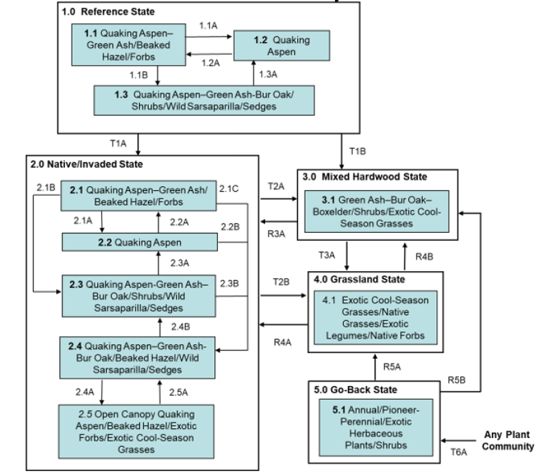
Five vegetative states have been identified for the site (Reference, Native/Invaded, Mixed Hardwood, Grassland, and Go-Back). Within each state, one or more community phases have been identified. These community phases are named based on the more dominant and visually conspicuous species; they have been determined by study of historical documents, relict areas, scientific studies, and ecological aspects of plant species and plant communities. Transitional pathways and thresholds have been determined through similar methods.
State 1: Reference State represents the historical natural range of variability that dominated the dynamics of this ecological site prior to European influence. This state may be characterized as a quaking aspen dominated forest with a beaked hazel understory; it is thought to have shifted temporally and spatially between three plant community phases. The major differences in the community phases are due to the age classes of quaking aspen.
Since European influence, however, fires have been significantly reduced while other disturbances, such as timber harvesting and grazing by domestic livestock, have increased. As a result, the historical disturbance regime no longer exists; communities representing the Reference State are considered rare. Thus, the presence of exotic plants on the site (e.g., Kentucky bluegrass, smooth brome, common buckthorn) precludes it from being placed in the Reference State. It must be placed in one of the other states, commonly State 2: Native/Invaded State (T1A). Removal of all disturbance will lead to State 3: Mixed Hardwood State (T1B).
State 2: Native/Invaded State. This state forms outside the historical disturbance regime, largely because of the long-term elimination of fire, timber harvesting, livestock grazing, and the introduction of exotic plants (particularly exotic cool-season grasses). Community phases are similar to those of the Reference State but have been invaded by exotic plants. Removal of all disturbances will lead to a transition to State 3: Mixed Hardwood State (T2A). Clear-cutting followed by heavy continuous grazing will lead to State 4: Grassland State (T2B).
Kentucky bluegrass and/or smooth brome are the main exotic cool-season grasses. Presently the distribution of common buckthorn in MLRA 55A has been relatively limited. However, it is spreading; due to its invasive nature and habit of displacing native understory species, is a threat to biodiversity. As a result, periodic monitoring for the species is recommended; if the plant is encountered, control measures implemented.
State 3: Mixed Hardwood State. This state may develop under conditions of long-term lack of disturbance and is dominated by green ash and bur oak, along with associates of boxelder, paper birch, and perhaps quaking aspen. Considerable variation may exist in the relative abundance of the dominant tree species due to variations in slope, precipitation, and other natural and anthropogenic factors. Reestablishment of natural disturbance regimes (e.g., prescribed burning or shearing) will lead to State 2: Native/Invaded State (R3A) provided remaining quaking aspen are still viable to regenerate.
State 4: Grassland State. This state consists of one community phase and may occur due to clear- cutting with continuous heavy grazing from State 2: Native/Invaded State (T2B) or State 3: Mixed Hardwood State (T3A). It may also result from State 5: Go-Back State through a range, pasture, or hayland planting (R5A). A Tree-Shrub Establishment (forestry planting) may lead to State 2: Native/Invaded State (R4A) or State 3: Mixed Hardwood State (R4B).
State 5: Go-Back State often results from cropland abandonment and consists of only one community phase. This weedy assemblage may include noxious weeds that need control. Initially, due to extensive bare ground and a preponderance of shallow rooted annual plants, the potential for soil erosion is high. Plant species richness may be high, but overall diversity (i.e., equitability) is typically low, with the site dominated by a relatively small assemblage of species. Due to the lack of native perennials and other factors, restoring the site with the associated ecological processes is difficult. A Tree-Shrub Establishment (forestry planting) leads to State 3: Mixed Hardwood State (R5B) while a range, pasture, or hayland planting leads to State 4: Grassland State (R5A).
A well designed/successful tree/shrub planting may result in something approaching State 2: Native/Invaded State. Following planting, management techniques that maintain the planting will need to be carefully constructed, evaluated, and monitored with respect to that objective.
The following state and transition model diagram illustrates the common states, community phases, community pathways, and transition and restoration pathways that can occur on the site. These are the most common plant community phases and states based on current knowledge and experience; changes may be made as more data are collected. Pathway narratives describing the site’s ecological dynamics reference various management practices (e.g., prescribed burning, brush management, herbaceous weed treatment) which, if properly designed and implemented, will positively influence plant community competitive interactions. The design of these management practices will be site specific and should be developed by knowledgeable individuals; based upon management goals and a resource inventory; and supported by an ongoing monitoring protocol.
When the management goal is to maintain an existing plant community phase or restore to another phase within the same state, modification of existing management to ensure native species have the competitive advantage may be required. To restore a previous state, the application of two or more management practices in an ongoing manner will be required. Whether using prescribed burning, with or without additional practices (e.g., brush management), the timing and method of application needs to favor the native species over the exotic species. Adjustments to account for variations in annual growing conditions and implementing an ongoing monitoring protocol to track changes and adjust management inputs to ensure desired outcome will be necessary.
The plant community phase composition table(s) has been developed from the best available knowledge including research, historical records, clipping studies, and inventory records. As more data are collected, plant community species composition and production information may be revised.
State and transition model
More interactive model formats are also available.
View Interactive Models
Click on state and transition labels to scroll to the respective text
Ecosystem states
| T1A | - | Invasion by exotic grasses and forbs |
|---|---|---|
| T1B | - | Removal of all disturbances |
| T2A | - | Removal of all disturbances |
| T2B | - | Clear Cutting with heavy continuous grazing. |
| R3A | - | Re-establishment of natural disturbance regimes (i.e. prescribed burning). |
| T3A | - | Clear Cutting with heavy continuous grazing |
| R4A | - | Tree-Shrub Establishment (forestry planting). |
| R4B | - | Tree-Shrub Establishment (forestry planting). |
| R5B | - | Tree-Shrub Establishment (forestry planting) |
| R5A | - | Range, pasture, or hayland planting. |
| T6A | - | Elimination of annual cropping. |
State 1 submodel, plant communities
| 1.1A | - | Wildfire, aspen regeneration by prescribed burning, shearing, or timber harvest |
|---|---|---|
| 1.1B | - | Extended fire interval, removal of disturbances |
| 1.2A | - | Extended fire interval, removal of disturbances |
| 1.3A | - | Wildfire, aspen regeneration by prescribed burning, shearing, or timber harvest |
State 2 submodel, plant communities
| 2.1A | - | Wildfire, aspen regeneration by prescribed burning, shearing, or timber harvest |
|---|---|---|
| 2.1B | - | Extended fire interval, removal of disturbances |
| 2.1C | - | Introduction of domestic livestock |
| 2.2A | - | Extended fire interval, removal of disturbances |
| 2.2B | - | Introduction of domestic livestock |
| 2.3A | - | Wildfire, aspen regeneration by prescribed burning, shearing, or timber harvest |
| 2.3B | - | Introduction of domestic livestock |
| 2.4B | - | Removal of domestic livestock |
| 2.4A | - | Heavy continuous grazing |
| 2.5A | - | Prescribed grazing |
State 3 submodel, plant communities
State 4 submodel, plant communities
State 5 submodel, plant communities
State 1
Reference State
This state may be characterized as a quaking aspen dominated forest with a beaked hazel understory. Plant community phases occur as a mosaic across the site resulting from variations in the frequency and intensity of fires and other disturbances (e.g., blowdown, grazing/browsing by native ungulates, beaver). The major differences in the community phases are due to the age classes of quaking aspen predominant on the site resulting from these disturbances. The Reference State represents the natural range of variability that dominated the dynamics of this ecological site prior to European influence. This site is dominated by quaking aspen with a dense understory of beaked hazel. Other associated trees included green ash and boxelder, with bur oak reaching its maximum importance on south-facing slopes and paper birch reaching its greatest importance on north-facing slopes. Chokecherry, Saskatoon serviceberry, nannyberry, highbush cranberry, downy arrowwood, and prickly wild rose are commonly associated shrubs. Graminoids common to this state are limited largely to sedges (e.g., Sprengel’s, Pennsylvania), rough ricegrass, and fringed brome. Common forbs include wild sarsaparilla, agrimony, anise-root, black snakeroot, veiny meadow-rue, starry false lily of the valley, mayflower, golden zizia, bedstraws, and violets. Herbaceous diversity and production are inversely related to canopy shading. In older stands, canopy cover may be 90% or more, supporting an herbaceous component of mainly wild sarsaparilla and sedges. However, gaps in canopy cover (such as that created by heart rot and windthrow) result in increased light penetration and may lead to an increase in herbaceous diversity and production.
Characteristics and indicators. The reference state may still exist; however, due to changes in disturbances and other environmental factors (particularly the widespread occurrence of exotic species), it may be rare.
Resilience management. If intact, the reference state should probably be managed with current disturbance regimes which has permitted the site to remain in reference condition, as well as maintaining the quality and integrity of associated ecological sites. Maintenance of the reference state is contingent upon a monitoring protocol to guide management.
Community 1.1
Community Phase 1.1: Quaking Aspen-Green Ash/Beaked Hazel/ Forbs (Populus tremuloides-Fraxinus pennsylvanica/Corylus cornuta/ Forbs)
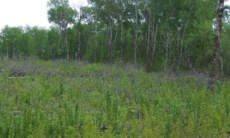
Figure 7. Photo depicting a two-year-old shearing to promote quaking aspen regeneration via community phase pathway 1.1A to plant community phase 1.2. This management technique mimics natural disturbance that stimulates quaking aspen regeneration.
Community Phase 1.1 is considered the Reference Plant Community upon which most interpretations are based. This community evolved with occasional fires, blowdown, and grazing/browsing by native ungulates. The community is dominated by quaking aspen between 20-50 years old (approximately 4-16 inches DBH), with green ash as the principal associate. Forbs characteristic to this community include wild sarsaparilla, veiny meadow-rue, starry false lily of the valley, bedstraws, and violets. The graminoid component is largely limited to sedges and rough ricegrass.
Figure 8. Annual production by plant type (representative values) or group (midpoint values)
Table 5. Annual production by plant type
| Plant type | Low (lb/acre) |
Representative value (lb/acre) |
High (lb/acre) |
|---|---|---|---|
| Shrub/Vine | 35400 | – | 40295 |
| Tree | 14950 | – | 17415 |
| Forb | 340 | – | 1220 |
| Grass/Grasslike | 645 | – | 850 |
| Grass/Grasslike | 565 | – | 800 |
| Total | 51900 | – | 60580 |
Figure 9. Plant community growth curve (percent production by month). ND5502, Central Black Glaciated Plains, cool-season dominant, warm-season sub-dominant.. Cool-season dominant, warm-season sub-dominant..
| Jan | Feb | Mar | Apr | May | Jun | Jul | Aug | Sep | Oct | Nov | Dec |
|---|---|---|---|---|---|---|---|---|---|---|---|
| J | F | M | A | M | J | J | A | S | O | N | D |
| 0 | 0 | 3 | 7 | 23 | 42 | 15 | 5 | 4 | 1 | 0 | 0 |
Community 1.2
Quaking Aspen (Populus tremuloides)
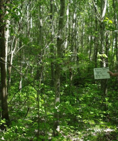
Figure 10. Photo depicting plant community phase 1.2 resulting from a 25 year-year-old quacking aspen shearing.
This plant community is the result of frequent fire events or other disturbances resulting in a forest community dominated by quaking aspen of age classes less than 20 years old (approximately less than 4 inches DBH). The community may be described as a virtually pure stand of young quaking aspen with a closed canopy that limits other trees, shrubs, and herbaceous species. Where the quaking aspen canopy is more open, a sparse shrub component may be composed of beaked hazel, chokecherry, Saskatoon serviceberry, highbush cranberry, and wild rose with herbaceous species largely consisting of wild sarsaparilla and sedges.
Community 1.3
Quaking Aspen-Green Ash-Bur Oak/ Shrubs/ Wild Sarsaparilla/ Sedges (Populus tremuloides-Fraxinus pennsylvanica-Quercus macrocarpa/ Shrubs/ Aralia nudicaulis/ Carex spp.)
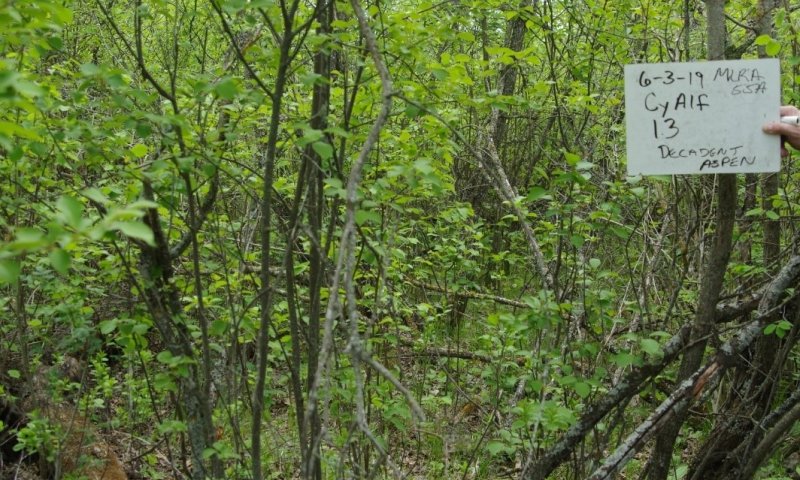
Figure 11. Photo depicting a decadent quaking aspen stand (plant community phase 1.3) transitioning to green ash and bur oak dominance (plant community phase 3.1).
This community may form when fires and other disturbances are so infrequent or minor as to enable quaking aspen that is 50 years old or more (approximately 16 or more inches DBH) to dominate the site. Major associates of the canopy and sub-canopy are green ash, bur oak, boxelder, and paper birch, with an understory shrub layer largely composed of beaked hazel along with chokecherry, Saskatoon serviceberry, wild rose, and highbush cranberry. The age of the quaking aspen is approaching maturity and may contain decadent trees as evidenced by increased heart rot, reduced canopy cover, and more frequent windthrow. Sedges and wild sarsaparilla account for most of the herbaceous component.
Pathway 1.1A
Community 1.1 to 1.2
Plant Community Phase 1.1 to 1.2 occurs when wind storms, timber harvesting, timber clearing, fire (wild or prescribed), or other disturbances cause considerable mortality of older quaking aspen and the stand is replaced with quaking aspen trees 20 years old or less. An effective technique for regenerating quacking aspen is to shear trees at ground level with a bulldozer during the winter when ground is frozen. Assuming the quaking aspen is not decadent and no longer can sprout readily, a strong sprouting response generally occurs (e.g. 20,000-40,000 stems per acre). Over time the stand will self-thin. A few selected trees of quaking aspen and other species may be left standing and will generally not interfere with the quaking aspen regeneration.
Pathway 1.1B
Community 1.1 to 1.3
Plant Community Phase 1.1 to 1.3 occurs when a low frequency of disturbance or an extended fire interval, or fires of low frequency and intensity are sufficient to allow the quaking aspen stand to age and become dominated by quaking aspen of at least 50-year-old trees.
Pathway 1.2A
Community 1.2 to 1.1
Plant Community Phase Pathway 1.2 to 1.1 occurs when infrequent disturbances or an extended fire interval is sufficient to enable 20-50 year old quaking aspen trees to dominate the site. The shrub understory of Community Phase 1.1 is typically more developed and diverse than that of Community Phase 1.2; it is often composed of beaked hazel with associates of chokecherry, Saskatoon serviceberry, wild rose, and highbush cranberry along with young green ash and bur oak forming a mid-canopy. The herbaceous layer is largely composed of wild sarsaparilla, veiny meadow-rue, starry false lily of the valley, bedstraws, and violets. Sedges and rough ricegrass are the main graminoids.
Pathway 1.3A
Community 1.3 to 1.2
Plant Community Phase 1.3 to 1.2 occurs when wind storms, timber harvesting, timber clearing, fire (wild or prescribed), or other disturbances cause considerable mortality of older quaking aspen and the stand is replaced with quaking aspen trees 20 years old or less. An effective technique for regenerating quaking aspen is to shear trees at ground level with a bulldozer during the winter when ground is frozen. Assuming the quaking aspen is not decadent and no longer can sprout readily, a strong sprouting response generally occurs (e.g. 20,000-40,000 stems per acre). Over time the stand will self-thin. A few selected trees of quaking aspen and other species may be left standing and will generally not interfere with the quaking aspen regeneration.
State 2
Native/Invaded State
This state may be described as consisting of similar community phases as is found in State 1: Reference State (i.e., Community Phases 1.1, 1.2, 1.3) but has been invaded by exotic plants. Also, the disturbances associated with the introduction of domestic livestock may markedly alter the native component and exacerbate the invasion by exotic plants (e.g., Community Phases 2.4 and 2.5). Initially, these changes are more structural than compositional. Domestic livestock establish travel corridors in the forest, as well as use the forest for shade and rest, which creates openings in the shrub component of the community. Over time, weaker stemmed shrubs (such as chokecherry, Saskatoon serviceberry, and highbush cranberry) decrease in abundance due to the increased disturbance. As a result, beaked hazel (which has stronger and more resistant stems) becomes even more dominant. Because the maximum height of grazing/browsing for cattle is about five feet, resprouts of quaking aspen and other woody vegetation within reach of the domestic livestock are subject to repeated herbivory, which will reduce recruitment. Continued season-long grazing by domestic livestock will lead to changes in the structure, composition, and production of the site. With a more open shrub component, increased light penetration to the forest floor leads to greater herbaceous production, particularly by sedges. The disturbance associated with continued season- long grazing exacerbates the invasion of the site by exotic plants. Presently the distribution of common buckthorn in MLRA 55A has been relatively limited. However, it is spreading; due to its invasive nature and habit of displacing native understory species, it is a threat to biodiversity. As a result, periodic monitoring for the species is recommended; if the plant is encountered, control measures implemented.
Characteristics and indicators. The presence of trace amounts of exotic cool-season grasses (e.g., Kentucky bluegrass and smooth brome) indicates a transition from State 1 to State 2. The presence of exotic biennial or perennial forbs (e.g., common dandelion, red clover, white clover, and black medic) may not, on their own, indicate a transition from State 1 to State 2 but may facilitate that transition.
Resilience management. The invasion of these exotic grasses is associated with stand clearing activities such as shearing or intensive fire which removes tree canopy cover. Canopy closure may reduce or eliminated exotics species. To maintain State 2.0 Native/Invaded State, forest management practices need to be completed. Livestock grazing is incompatible with maintaining a forest dominated state; it will likely result in a pathway to an open canopy (Plant Community Phases 2.4/2.5).
Community 2.1
Quaking Aspen-Green Ash/ Beaked Hazel/ Forbs (Populus tremuloides-Fraxinus pennsylvanica/ Corylus cornuta/ Forbs)
This community is similar to Community Phase 1.1 (dominated by quaking aspen 20-50 years old) but now supports populations of exotic plants. Common exotics may include Kentucky bluegrass, smooth brome, common dandelion, white clover, red clover, and black medic.
Community 2.2
Quaking Aspen (Populus tremuloides)
This community is similar to Community Phase 1.2 (dominated by quaking aspen 20 years old or less) but now supports populations of exotic plants. Shading by young and vigorous growth of quaking aspen may limit exotics, but as the stand matures the canopy opens-up. Common exotics may include Kentucky bluegrass, smooth brome, common dandelion, white clover, red clover, and black medic.
Community 2.3
Quaking Aspen-Green Ash-Bur Oak/ Shrubs/ Wild Sarsaparilla/ Sedges (Populus tremuloides-Fraxinus pennsylvanica-Quercus macrocarpa/ Shrubs/ Aralia nudicaulis/ Carex spp.)
This community is similar to Community Phase 1.3 (dominated by quaking aspen 50 years old or older), but now supports populations of exotic plants (such as Kentucky bluegrass, smooth brome, red clover, white clover, and black medic).
Community 2.4
Quaking Aspen-Green Ash-Bur Oak/ Beaked Hazel/ Wild Sarsaparilla/Sedges (Populus tremuloides-Fraxinus pennsylvanica-Quercus macrocarpa/ Corylus cornuta/ Aralia nudicaulis/ Carex spp.)
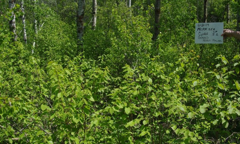
Figure 12. Community Phase 2.4: Quaking Aspen-Green Ash-Bur Oak/Beaked Hazel/Wild Sarsaparilla/Sedges - Photo depicts a grazed site resulting in plant community phase 2.4.
This community phase is similar to Community Phase 2.3 but with major differences, principally in the shrub component, due to grazing/browsing by domestic livestock. Continued season-long grazing by domestic livestock begins to open the shrub component resulting in a decline of weaker stemmed shrubs (e.g., chokecherry, Saskatoon serviceberry, highbush cranberry) and an increase in beaked hazel which has stronger stems. Also, the recruitment of quaking aspen resprouts and other woody species decline which further facilitates the invasion of exotic forbs and exotic grasses
Community 2.5
Open Canopy Quaking Aspen/ Beaked Hazel/ Exotic Forbs/ Exotic Cool-Season Grasses (Open Canopy Populus tremuloides/ Corylus cornuta/ Exotic Forbs/ Exotic Cool-Season Grasses)
This community phase may be characterized by a quaking aspen forest, generally of an older age class, where the disturbance of unregulated grazing by domestic livestock (e.g., soil compaction, trailing, bedding, and the like) has led to a decline in vigor and increased mortality of the forest canopy species. These effects, in combination with the aging aspen canopy and aspen heart rot, result in a more open and decadent stand of quaking aspen with little or no recruitment. Other canopy species, such as bur oak and green ash, also show signs of decline (e.g., barking, increase in dead branches). Beaked hazel may dominate the shrub component but, over time, will decline with heavy season-long grazing.
Pathway 2.1A
Community 2.1 to 2.2
Community Phase Pathway 2.1 to 2.2 occurs when wildfire or aspen regeneration by prescribed burning, shearing, or timber harvesting results in a forest community dominated by quaking aspen of age classes less than 20 years old.
Pathway 2.1B
Community 2.1 to 2.3
Community Phase Pathway 2.1 to 2.3 occurs when a low frequency of disturbance, an extended fire interval, or fires of low frequency and intensity are sufficient to allow the quaking aspen stands to age and become dominated by quaking aspen of at least 50-year-old trees.
Pathway 2.1C
Community 2.1 to 2.4
Community Phase Pathway 2.1 to 2.4 occurs with the introduction of domestic livestock resulting in a more open forest canopy and shrub component leading to an increase in exotic plants.
Pathway 2.2A
Community 2.2 to 2.1
Community Phase Pathway 2.2 to 2.1 occurs when infrequent disturbances or an extended fire interval is sufficient to enable 20-50-year-old quaking aspen trees to dominate the site.
Pathway 2.2B
Community 2.2 to 2.4
Community Phase Pathway 2.2 to 2.4 occurs with the introduction of domestic livestock resulting in a more open forest canopy and shrub component leading to an increase in exotic plants.
Pathway 2.3A
Community 2.3 to 2.2
Community Phase Pathway 2.3 to 2.2 occurs when windstorms, timber harvesting, timber clearing, fire (wild or prescribed), or other disturbances cause considerable mortality of older quaking aspen, and the stand is replaced with quaking aspen trees 20 years old or less.
Pathway 2.3B
Community 2.3 to 2.4
Community Phase Pathway 2.3 to 2.4 occurs with the introduction of domestic livestock resulting in a more open forest canopy and shrub component leading to an increase in exotic plants.
Pathway 2.4B
Community 2.4 to 2.3
Community Phase Pathway 2.4 to 2.3 occurs with the removal of domestic livestock which allows for the increase in shrub abundance and diversity (e.g., chokecherry, Saskatoon serviceberry, highbush cranberry).
Pathway 2.4A
Community 2.4 to 2.5
Community Phase Pathway 2.4 to 2.5 occurs with heavy continuous grazing by domestic livestock. Livestock herbivory and disturbance lead to a more open forest canopy and a shrub layer composed of the stronger stemmed beaked hazel. This leads to the establishment of an herbaceous component dominated by exotic plants.
Pathway 2.5A
Community 2.5 to 2.4
Community Phase Pathway 2.5 to 2.4 may occur with the implementation of a prescribed grazing system which includes occasional deferment or rest from grazing, enabling trees and shrubs to grow to heights of five feet or more, thus ameliorating the grazing/browsing effects on recruitment.
State 3
Mixed Hardwood State
This state may develop under conditions of long-term lack of disturbance (>50 years), allowing the mature quaking aspen dominated forest to become decadent and be replaced by green ash and bur oak along with associates of boxelder and paper birch. Quaking aspen is a shade intolerant species, thus generally regarded as an early successional species that would give way to more shade tolerant species in later successional states. As such, in a traditional successional pathway on this site quaking aspen would be expected to be replaced by more shade tolerant species (such as green ash, bur oak, and boxelder). However, in some instances quaking aspen may persist. It is unclear to what extent quaking aspen may remain in this community. Considerable variation may exist in the relative abundance of the dominant tree species in this state. Those variations appear to be a function of variations in slope, precipitation, and other natural and anthropogenic factors. For example, bur oak may dominate on a south-facing slope while paper birch may predominate on a north-facing slope.
Characteristics and indicators. The dominance of woody species (by cover and production) distinguishes this state from other herbaceously dominated states.
Resilience management. This state is resistant to change in the long-term absence of fire. Restoration efforts would require the use of prescribed fire and tree/shrub planting. Considerable time, effort and monetary resources will be required to restore to other States.
Community 3.1
Green Ash-Bur Oak/Shrubs/Exotic Cool-Season Grasses
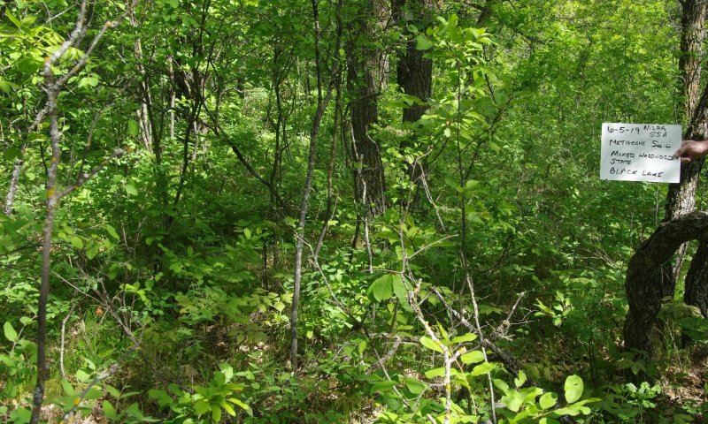
Figure 13. Photo depicting plant community phase 3.1.
This community phase may be characterized as a green ash and bur oak dominated forest with paper birch and boxelder as the principal associates with a rather sparse shrub understory of chokecherry, downy arrowwood, Saskatoon serviceberry, highbush cranberry, and perhaps beaked hazel. Quaking aspen may or may not be retained in the community. Due to heavy shading, the production and diversity of graminoids and forbs are limited.
State 4
Grassland State
Clear-cutting, combined with long-term heavy grazing, maintains a grass dominated site. Clear- cutting for the purpose of livestock grazing may also transition this site to grassland. This state may also occur with the successful seeding to native and/or introduced grasses from State 5.0 Go Back, with or without introduced legumes or native forbs (R5A).
Characteristics and indicators. This state is dominated by seeded, native or introduced, perennial herbaceous species.
Resilience management. Successful grass seeding, via R5A, will be based on the grass and forb species seeded. Management to maintain this site will be needed to avoid encroachment of woody species, dependent upon managers’ goals.
Community 4.1
Exotic Cool-Season Grasses/Native Grasses/Exotic Legumes/Native Forbs.
This plant community is a result of the type of seed mix being used to plant the site to a grassland state.
State 5
Go-Back State
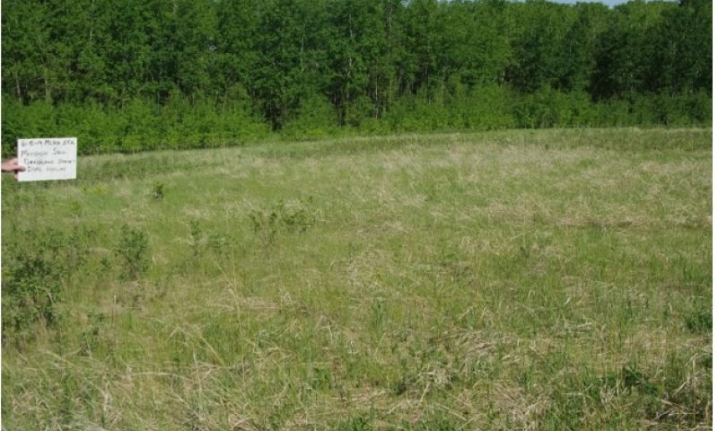
Figure 14. State 5: Go Back State - Photo depicts an old field (Go Back State, plant community phase 4.1) where the quaking aspen is reestablishing on the site from around the edges.
This state typically results from the abandonment of cropland, hayland, or residences/farmsteads. Vegetation is typically dominated by Kentucky bluegrass and smooth brome. Common associates include western snowberry, wild rose, northern bedstraw, common dandelion, Canada goldenrod, common yarrow, and Canada thistle. Sprouts from adjacent stands of aspen or beaked hazel often encroach onto the site, as well as seedlings of adjacent green ash.
Characteristics and indicators. Tillage has destroyed the native plant community, altered soil structure and biology, reduced soil organic matter, and resulted in the formation of a tillage induced compacted layer which is restrictive to root growth. Removal of perennial grasses and forbs results in decreased infiltration and increased runoff.
Resilience management. Continued tillage will maintain the state. Control of noxious weeds will be required.
Community 5.1
Annual/Pioneer-Perennial/Exotic Herbaceous Plants/Shrubs
This community typically occurs when cropland or hayland is abandoned, allowing the site to “go back”. Various weedy species initially dominate the vegetation of the site. Weed control, particularly for noxious weeds (e.g., Canada thistle), may be necessary.
State 6
Any Plant community
Usually consists of cropland.
Transition T1A
State 1 to 2
This is the transition from the Reference State, to the Native/Invaded State. The transition is initiated by the establishment of exotic plants. Kentucky bluegrass, smooth brome, common dandelion, red clover, white clover, and black medic are among the more common exotics.
Constraints to recovery. (i.e. variables or processes that preclude recovery of the former state). Current knowledge and technology will not facilitate a successful restoration to Reference State.
Transition T1B
State 1 to 3
This is the transition from the Reference State to the Mixed Hardwood State due to removal of disturbances such as fire, resulting in the change from a quaking aspen dominated forest to that of more shade tolerant species characterized by green ash and bur oak, with associates of paper birch and boxelder.
Constraints to recovery. Current knowledge and technology will not facilitate a successful restoration to Reference State.
Restoration pathway T2A
State 2 to 3
This is the transition from State 2: Native/Invaded State to State 3: Mixed Hardwood State by the removal of all disturbances. Exotic cool season grasses and forbs may become minor components as the tree canopy increases and shading allows for species such as sedges to increase.
Context dependence. Decadent quaking aspen (over 50 years old) or loss of aspen entirely may not recovery to State 2.0 Native/Invaded State.
Transition T2B
State 2 to 4
This is the transition from the State 2: Native/Invaded State to State 4: Grassland State by clear- cutting with heavy continuous grazing.
Constraints to recovery. Labor, time, and expense, along with long term management needs (via R4B) may limit success.
Transition R3A
State 3 to 2
Reestablishment of natural disturbance regimes (i.e. prescribed burning) may enable the Mixed Hardwood State to return to the Native/Invaded State assuming a small amount of quaking aspen is present in the community, or comes into the site vegetatively from the periphery, by seed, or planting.
Context dependence. Shearing needs to be completed at a time when the soils are frozen to minimize ground disturbance. Size of an area shearing is dependent on management needs
Transition T3A
State 3 to 4
This transition is the result of clear-cutting with continuous heavy grazing, from State 3: Mixed Hardwoods to State 4: Grassland State.
Constraints to recovery. Labor, time, and expense, along with long term management needs (via R4B) may limit success.
Restoration pathway R4A
State 4 to 2
A Tree-Shrub Establishment (forestry planting) may lead to the restoration of State 4: Grassland State to State 2: Native/Invaded State. It is similar to that of R4B but differs in species of trees planted.
Context dependence. Labor, time, and expense of tree and shrub planting, along with long-term management needs (via R4A), may limit success. Aspen encroachment will slowly occur from the edges of existing stands. Over time, annual and pioneer perennial plants, along with exotics, may be outcompeted by encroaching aspen as canopy increases.
Restoration pathway R4B
State 4 to 3
A Tree-Shrub Establishment (forestry planting) may lead to the restoration of State 4: Grassland State to State 2: Native/Invaded State. It is similar to that of R4A but differs in species of trees planted.
Context dependence. Labor, time, and expense of tree and shrub, planting along with long term management needs via R4A, may limit success. Aspen encroachment will slowly occur from the edges of existing stands. Over time, annual and pioneer perennial plants (along with exotics) will be outcompeted by encroaching aspen as canopy increases.
Transition R5B
State 5 to 3
This restoration from the State 5: Go-Back State to the State 3: Mixed Hardwood State may occur with a successful Tree-Shrub Establishment (forestry planting). A transition to Mixed Hardwood State may also be possible only with the removal of disturbances allowing trees/shrubs to establish via seed sources or encroach vegetatively from adjacent sites.
Context dependence. Labor, time, and expense of tree and shrub planting, along with long term management needs (via R4A), may limit success. Aspen encroachment will slowly occur from the edges of existing stands. Over time, annual and pioneer perennial plants (along with exotics) will be outcompeted by encroaching aspen as canopy increases.
Restoration pathway R5A
State 5 to 4
This restoration pathway from State 5: Go-Back State to State 4: Grassland State can be accomplished with a range, pasture, or hayland planting. Prescribed grazing, burning, haying, brush management (mechanical and/or chemical) will generally be necessary to achieve the desired plant community phase.
Context dependence. A successful range planting will include proper seedbed preparation, weed control (both prior to and after the planting), selection of adapted native species representing functional/structural groups inherent to the State 1, and proper seeding technique. Management (e.g., prescribed grazing, prescribed burning) during and after establishment must be applied in a manner that maintains the competitive advantage for the seeded native species. Adding non-native species can impact the above and below ground biota. Some evidence suggests the addition of exotic legumes to the seeding mixture may favor exotic cool-season grass expansion/invasion. Maintaining State 4.0 Grassland State may also require a method of brush management that will be site specific; generally, the goal would be to apply the pesticide and mechanical control (either singularly or in combination) in a manner that shifts the competitive advantage from the targeted control species to the native grasses and forbs. The control method(s) should be as specific to the targeted control species as possible to minimize impacts to non-target species.
Restoration pathway T6A
State 6 to 5
This transition is from any plant community to State 5: Go-Back State. It is most commonly associated with the cessation of cropping without the benefit of range planting, resulting in a “go-back” situation. Soil conditions can be quite variable on the site, in part due to variations in the management/cropping history (e.g., development of a tillage induced compacted layer (plow pan), erosion, fertility, and/or herbicide/pesticide carryover). Thus, soil conditions should be assessed when considering restoration techniques.
Additional community tables
Table 6. Community 1.1 plant community composition
| Group | Common name | Symbol | Scientific name | Annual production (lb/acre) | Foliar cover (%) | |
|---|---|---|---|---|---|---|
|
Tree
|
||||||
| 1 | Trees | 14950–17415 | ||||
| green ash | FRPE | Fraxinus pennsylvanica | 7565–13200 | – | ||
| quaking aspen | POTR5 | Populus tremuloides | 0–8850 | – | ||
| bur oak | QUMA2 | Quercus macrocarpa | 1000–1750 | – | ||
|
Shrub/Vine
|
||||||
| 2 | lower trees/shrubs | 35400–40295 | ||||
| beaked hazelnut | COCO6 | Corylus cornuta | 20250–34250 | 22–42 | ||
| chokecherry | PRVI | Prunus virginiana | 0–20000 | 0–5 | ||
| Woods' rose | ROWO | Rosa woodsii | 0–1150 | 0–5 | ||
| green ash | FRPE | Fraxinus pennsylvanica | 0–250 | 10–26 | ||
| American cranberrybush | VIOPA2 | Viburnum opulus var. americanum | 0–100 | 0–5 | ||
| bur oak | QUMA2 | Quercus macrocarpa | 0–100 | 0–5 | ||
| American red raspberry | RUID | Rubus idaeus | 0–45 | 0–5 | ||
|
Grass/Grasslike
|
||||||
| 3 | Grasses | 645–850 | ||||
| roughleaf ricegrass | ORAS | Oryzopsis asperifolia | 30–50 | 0–8 | ||
| fringed brome | BRCI2 | Bromus ciliatus | 0–50 | 0–5 | ||
| 4 | Sedges | 565–800 | ||||
| Sprengel's sedge | CASP7 | Carex sprengelii | 0–50 | – | ||
| Pennsylvania sedge | CAPE6 | Carex pensylvanica | 30–50 | – | ||
|
Forb
|
||||||
| 5 | Forbs | 340–1220 | ||||
| wild sarsaparilla | ARNU2 | Aralia nudicaulis | 300–970 | 15–36 | ||
| Canada mayflower | MACA4 | Maianthemum canadense | 0–115 | 0–5 | ||
| bedstraw | GALIU | Galium | 25–50 | 0–5 | ||
| veiny meadow-rue | THVE | Thalictrum venulosum | 0–25 | 0–5 | ||
| Virginia strawberry | FRVI | Fragaria virginiana | 0–25 | 0–5 | ||
| violet | VIOLA | Viola | 0–25 | 0–5 | ||
| giant goldenrod | SOGI | Solidago gigantea | 0–25 | 0–5 | ||
| red baneberry | ACRU2 | Actaea rubra | 0–25 | 0–5 | ||
Table 7. Community 1.1 forest overstory composition
| Common name | Symbol | Scientific name | Nativity | Height (ft) | Canopy cover (%) | Diameter (in) | Basal area (square ft/acre) |
|---|---|---|---|---|---|---|---|
|
Tree
|
|||||||
| quaking aspen | POTR5 | Populus tremuloides | Native | – | 58–78 | – | – |
| green ash | FRPE | Fraxinus pennsylvanica | Native | – | 14–28 | – | – |
| bur oak | QUMA2 | Quercus macrocarpa | Native | – | 0–5 | – | – |
Interpretations
Animal community
Animal Community – Wildlife Interpretations
Landscape
The MLRA 55A landscape is characterized by mostly nearly level to gently rolling till plains with some steep slopes adjacent to streams. The MLRA includes areas of kettle holes, kames, and ground moraines. MLRA 55A is considered to have a continental climate with cold winters and hot summers, low humidity, light rainfall, and much sunshine. Extremes in temperature are common and characteristic of the MLRA. This area supports mid- to tall-grass prairie vegetation with quaking aspen, bur oak, green ash, and willow species growing on the higher elevations in Turtle Mountain, on moraines in proximity of Devils Lake, Pembina River Escarpment and Gorge, and various drainageways throughout the MLRA. Numerous depressional wetlands are ringed with quaking aspen. Complex intermingled ecological sites create diverse grass/shrub land habitats interspersed with varying densities of linear, slope, depressional, and in-stream wetlands associated with headwater streams and tributaries of the Souris and Pembina Rivers. MLRA 55A is located entirely within North Dakota and within the boundaries of the Prairie Pothole Region. The primary land use is cropland. Glacial Lake Souris and the Devils Lake Basin are known for exceptional fertility with major crops including corn, canola, soybeans, and small grains. Together, these two areas make up 73% of the MLRA (Glacial Lake Souris 5500 mi2, 43%; and the Devils Lake Basin 3810 mi2, 30%).
Turtle Mountain (1000 mi2 of which 405 mi2 are found in North Dakota), in the north-central part of the MLRA on the Canadian border, is approximately 1,950 to 2,541 feet (595 to 775 meters) in elevation, rising approximately 600 to 800 feet (150 meters) above the adjacent till plain. Home to an extensive forest of quaking aspen, bur oak, green ash, and willows, it has an understory of beaked hazel with associates of chokecherry, Saskatchewan serviceberry, downy arrowwood, and rose. Turtle Mountain comprises the largest area of quaking aspen forest in North Dakota.
The Pembina Escarpment extends from the Canadian border southeast to Walhalla where the Pembina River enters the floor of the Red River Valley in MLRA 56A. Mainly found on steep slopes along the Pembina River, the Pembina Gorge is in a rugged and sheltered setting with bur oak, green ash, cottonwood, and American elm. Encompassing approximately 12,500 acres, the Pembina Gorge is one of the largest uninterrupted blocks of woodlands in North Dakota. This segment of the Pembina River is the longest segment of unaltered river valley in the North Dakota.
Two major Hydrologic Unit Areas make up this MLRA. 56% of the MLRA drains into the Souris River while 44% drains into the Red River (via the Pembina River) or into Devils Lake (out-letting to Sheyenne River via a pump, pipeline, canal system). The North Dakota portion of the Souris River watershed is in this MLRA. The Souris River basin drains nearly 23,600 square miles and has a long history of flooding.
By the mid-19th century, over 75% of the MLRA had been converted from mid- to tall-grass prairie or woodland to annual crop production. To alleviate crop production loss from wetlands and overland flow, a system of shallow surface ditches, judicial ditches, and road ditches removes surface water in spring and during high rainfall events. Tile drainage systems have been or are being installed extensively throughout MLRA 55A for sub-surface field drainage to enhance annual crop production.
Historic Communities/Conditions within MLRA 55A:
The northern tall- and mixed-grass prairie along with the quaking aspen forest were disturbance- driven ecosystems with fire, herbivory, and climate functions as the primary ecological drivers (either singly or often in combination). American bison roamed MLRA 55A wintering along the Souris River and migrating through MLRA 55A into MLRAs 56A and 55B. Many species of grassland birds, small mammals, insects, reptiles, amphibians, elk, moose, pronghorn, and large herds of American bison were historically among the inhabitants adapted to this region. Roaming herbivores, as well as several small mammal and insect species, were the primary consumers linking the grassland resources to large predators (such as the wolf, American black bear, grizzly bear) and smaller carnivores (such as the coyote, bobcat, red fox, and raptors). Extirpated species include free-ranging American bison and gray wolf (breeding). Extinct is the Rocky Mountain locust.
Present Communities/Conditions within MLRA 55A:
This area supports natural prairie vegetation characterized by western wheatgrass, green needlegrass, needle and thread, and blue grama. Little bluestem is an important species on the more sloping and shallower soils. Prairie cordgrass, northern reedgrass, big bluestem, and wheat sedge are important species on soils with higher water tables. Western snowberry, leadplant, and prairie rose are commonly interspersed throughout the area. Native forests occur in Turtle Mountain, Pembina Gorge, moraines near Devils Lake, woody draws, scattered tracts along the Souris River, and in the sand dunes in west central region of the MLRA.
Over 75% of MLRA 55A has been converted to annual crop production. European influence has impacted remaining grassland, forestland, and shrubland by domestic livestock grazing, elimination of fire, tree harvest, removal of surface and subsurface hydrology via artificial drainage, and other anthropogenic factors influencing plant community composition and abundance.
Hydrological manipulation is extensive throughout the MLRA. Extensive wetland and subsurface tile drainage have taken place. Ephemeral and intermittent streams and the Souris River have been straightened - removing sinuosity, creating isolated oxbows, and converting riparian zones to annual crop production. These anthropogenic impacts have reduced flood water detention and retention on the landscape. The results have been increasing storm water runoff sediment and nutrient loading impacting the Souris and Des Lacs Rivers and their tributaries along with Devils Lake and other lakes within the MLRA. The installation of instream structures has reduced aquatic species movement within the MLRA. Two large dams in Saskatchewan, Canada (Rafferty on the Souris River and Alameda on Moose Mountain Creek, a major tributary to the Souris River) were built, in part, to reduce flood peaks on the Souris River. In addition, three USFWS National Wildlife Refuges were created by building two low-head dams on the Souris River and one on the Des Lacs River in North Dakota. Numerous low-head dams are located on the Souris and Des Lacs Rivers in North Dakota. The Eaton Irrigation Project low-head dam, located in the vicinity of Towner, North Dakota, provides flood irrigation to approximately 6,700 acres of hayland and pastureland.
The loss of the American bison and fire, as primary ecological drivers, greatly influenced the character of the remaining native plant communities and the associated wildlife moving towards a less diverse and more homogeneous landscape. Annual cropping is the main factor contributing to habitat fragmentation, reducing habitat quality for area-sensitive species. These influences fragmented the landscape, reduced or eliminated ecological drivers (fire), and introduced exotic species including smooth brome, Kentucky bluegrass, and leafy spurge which further impacted plant and animal communities. Included in this MLRA are over 121,000 acres of National Wildlife Refuges and over 77,000 acres of waterfowl production areas owned and managed by the United States Fish and Wildlife Service.
White Horse Hill National Game Preserve is a 1,674-acre national wildlife refuge sitting on the south shores of Devils Lake, about 10 miles south of the city of Devils Lake. Numerous state-owned parks, state wildlife management areas, North Dakota Forest Service and Department of Trust Lands are found in the MLRA. Wakopa Wildlife Management Area is the largest WMA covering approximately 6,739 acres.
Some characteristic wildlife species in this area are:
Birds: Common loon, common goldeye, bufflehead, ruffed grouse, broad-winged hawk, alder flycatcher, mourning warbler, mallard, blue-winged teal, red-tailed hawk, American kestrel, killdeer, eastern and western kingbird, American crow, common yellowthroat, clay-colored sparrow, vesper sparrow, red-necked grebe, Savannah sparrow, downy and hairy woodpeckers, black-capped chickadee, white-breasted nuthatch, and brown-headed cowbird.
Mammals: Northern short-tailed shrew, water shrew, beaver, muskrat, mink, long-tailed weasel, American martin, fisher, white-tailed jackrabbit, snowshoe hare, Franklin’s ground squirrel, thirteen- lined ground squirrel, northern pocket gopher, plains pocket gopher, western harvest mouse deer mouse, meadow vole, meadow jumping mouse, western jumping mouse, coyote, red fox, racoon, American badger, striped skunk, white-tailed deer, elk, moose, and woodchuck, red squirrel, porcupine, and northern flying squirrel.
Reptiles/Amphibians: American toad, Great Plains toad, northern leopard frog, chorus frog, tiger salamander, plains garter snake, smooth green snake, wood frog, and common garter snake.
Presence of wildlife species is often determined by ecological site characteristics including grass and forb species, tree and shrub species, hydrology, aspect, and other associated ecological sites. The home ranges of a majority species are usually larger than one ecological site or are dependent on more than one ecological site for annual life requisites. Ecological sites offer different habitat elements as the annual life requisites change. Habitat improvement and creation must be conducted within the mobility limits of a known population for the species.
Insects play an important role providing ecological services for plant community development. Insects that are scavengers or aid in decomposition provide the food chain baseline sustaining the carnivorous insects feeding upon them. Many insects provide the ecological services necessary for pollination, keeping plant communities healthy and productive. Insects provide a protein food source for numerous species including grassland-nesting birds, woodpeckers, and woodland edge and interior species, and their young. Extensive use of insecticides for specialty crops (such as soybeans, corn, and other crops) has greatly reduced insects within this MLRA.
Species of Concern within MLRA 55A:
The following is a list of species considered “species of conservation priority” in the North Dakota State Wildlife Action Plan (2015) and “species listed as threatened, endangered, or petitioned” under the Endangered Species Act within MLRA 55A at the time this section was developed:
Invertebrates: Dakota skipper, monarch butterfly, and regal fritillary. Within the MLRA, the United States Fish and Wildlife Service lists 5 areas (in Rolette and McHenry Counties) as critical habitat for the Dakota skipper.
Birds: American avocet, American bittern, American kestrel, American white pelican, Baird’s sparrow, bald eagle, black tern, black-billed cuckoo, bobolink, canvasback, chestnut-collared longspur, ferruginous hawk, Franklin’s gull, grasshopper sparrow, horned grebe, LeConte’s sparrow, lesser scaup, loggerhead shrike, marbled godwit, Nelson’s sparrow, northern harrier, northern pintail, piping plover, sharp-tailed grouse, short-eared owl, Sprague’s pipit, Swainson’s hawk, upland sandpiper, western meadowlark, whooping crane, willet, Wilson’s phalarope, and yellow rail.
Mammals: American martin, Arctic shrew, big brown bat, gray fox, little brown bat, northern long- eared bat, plains pocket mouse, pygmy shrew, Richardson’s ground squirrel, river otter, and Townsend’s big-eared bat.
Amphibians/Reptiles: Canadian toad, common snapping turtle, plains hog-nosed snake, and smooth green snake.
Fish: Finescale dace, hornyhead chub, largescale stoneroller, logperch, northern pearl dace, and trout-perch.
Mussels: Black sandshell, creek heelsplitter, creeper, mapleleaf, and pink heelsplitter.
Grassland and Woodland Management for Wildlife in the MLRA 55A
Management activities within the community phase pathways impact wildlife but are essential for maintenance of healthy grassland ecosystems. Community phase, transitional, and restoration pathways are keys to long-term management within each State and between States. Timing, intensity, and frequency of these inputs can have dramatic positive or negative effects on local wildlife species. Ranchers and other land managers must always consider the long-term beneficial management effects of grassland and woodland resources in comparison to typically short-term negative effects to the habitats of individual species.
Ecological sites occur as intermingled complexes on the landscape with gradual or sometimes abrupt transitions. Rarely do ecological sites exist in large enough acreage to manage independently for wildlife. Conversion to annual cropping and fragmentation due to transportation and electrical transmission corridors and to rural housing are main causes of fragmentation. This MLRA supports ecological sites that are dominated by woody vegetation and can be located adjacent to ecological sites that support tall- to mid-statured grasses (Thin Loamy/Shallow Loamy) or are adjacent to ecological sites that support wetland vegetation (Shallow Marsh and Wet Meadow).
Management of these ecological site complexes challenges managers to properly manage the entire landscape. A management strategy for one ecological site may negatively impact an adjacent site. For example, grazing Upland Hardwood Forest or Loamy Savannah ecological sites along with herbaceous dominated Loamy Overflow ecological sites may degrade one site by under-use, favoring woody vegetation or increasing exotic cool-season grasses.
Life requisites and habitat deficiencies are determined for targeted species. Deficiencies need to be addressed along community phase, transitional, and restoration pathways as presented in specific state-and-transition models. Ecological sites should be managed and restored within the site’s capabilities to provide sustainable habitat for targeted species or species guilds. Managers also need to consider vegetative associations provided by adjacent/intermingled ecological sites for species with home ranges or life requisites that may not be provided by one ecological site. Understanding specific grassland species’ sensitivity to woody encroachment and preferred vegetative structure enables managers to determine which grassland-nesting bird species will avoid grassland habitats adjacent to Upland Hardwood Forest or Loamy Savannah ecological sites or woody dominated, Plant Community Phase 5, Loamy ecological site.
Many passerine species utilize MLRA 55A as a major migratory travel corridor. Grassland species sensitive to woody associations during nesting and brooding may utilize the woodier fragmented sites, such as the Wooded State 5.0 in the Loamy ecological site, during migration.
Grassland-nesting birds use various grass heights for breeding, nesting, foraging, or winter habitat. While most species use varying heights, many have a preferred vegetative stature height or sensitivity to woody vegetation. Understanding the sensitivity of grassland species to woody vegetation and preferred vegetative structure enables managers to determine which grassland-nesting bird species avoid grassland habitats adjacent to Upland Hardwood Forest or Loamy Savannah ecological sites.
The following chart provides sensitivity to woody vegetation and preferred vegetative stature heights. See PDF document for full table to be located at:
https://efotg.sc.egov.usda.gov/#/state/ND/documents/section=2&folder=52065
Upland Hardwood Forest Wildlife Habitat Interpretation:
Upland Hardwood Forest ecological sites are located on moraines (Turtle Mountain), escarpments (Pembina Gorge), lake plains, and dissected uplands. No significant water table or surface run-on influences vegetation production on this site. Associated ecological sites include Clayey, Loamy Savannah, Thin Loamy, Shallow Marsh, and Shallow Loamy.
Upland Hardwood Forest habitat features and components support woodland edge and interior birds and other wildlife species dependent upon trees and shrubs to meet their life requisites. These forested sites provide quality loafing, escape, and winter cover for small and large herbivores and quality year-round habitat for American marten, snowshoe hare, elk, moose, and white-tailed deer. These sites provide for many migratory passerines and year-round habitat for ruffed grouse and quality winter cover for eastern screech owl, great horned owl, wild turkey, and non-migrating passerine birds (such as black-capped chickadee and white-breasted nuthatch). Grassland-nesting birds avoid these ecological sites unless converted to herbaceous vegetation. Grassland-nesting birds that commonly avoid woody vegetation will not have their habitat needs met and may avoid adjacent ecological sites dominated by grassland vegetation. A reduction in nesting success by grassland nesting birds on adjacent herbaceous sites is likely due to increases in avian predation and nest parasitism.
Upland Hardwood Forest ecological sites may be found in five plant community states (1.0 Reference State, 2.0 Native/Invaded State, 3.0 Mixed Hardwood State, 4.0 Go Back State and 5.0 Grassland state) within a local landscape. Multiple plant community phases exist within State 1.0 and 2.0. Today, these states occur primarily in response to precipitation (extended periods of above normal precipitation and drought), fire, grazing, non-use, and other anthropogenic disturbances.
Because there is no known restoration pathway from State 2.0 to State 1.0, it is important to intensively manage using tools in State 1.0 Community Phase Pathways to prevent further plant community degradation along the T1A Transitional Pathway to State 2.0 or T1B Transitional Pathway to State 3.0.
1.0 Reference State
Community Phase 1.1 Quaking Aspen-Green Ash/Beaked Hazel/Forbs: Dominated by quaking aspen between 20-50 years old, this plant community offers quality woody vegetative cover for wildlife, especially ruffed grouse; every effort should be made, when found, to maintain this ecological site within this community phase. Ecological services, historically provided by fire and large native ungulates, are simulated by mechanical shearing of the quaking aspen forest on a long-term rotational basis. Historically, infrequent stand-replacing fires kept this community within State 1.0. Managers should consider management within the State 1.0 Community Phase Pathways to avoid transitioning to other states, especially if ruffed grouse habitat is the goal.
Invertebrates: Dense overstory of quaking aspen and green ash provide shade with little sunlight reaching flowering plants, such as forbs and shrubs. Pollen and nectar sources are limited; in addition, day-long shade limits use by pollinating insects. However, insects do play a role in maintaining the limited forb community and provide a forage base for woodland birds, reptiles, and rodents. Plant materials and dung in contact with mineral soil are used by lower trophic level consumers (such as invertebrate decomposers, scavengers, shredders, predators, herbivores, dung beetles, and fungal feeders).
Upland Hardwood Forest ecological sites provide habitat for a variety of butterflies. Knutson and Post (1963) and Royer (2003) list several butterfly species associated with Turtle Mountain and found in Bottineau County, ND. Included are Arctic skipper, Hobomok skipper, roadside skipper, black swallowtail, tiger swallowtail, coral hairstreak, Edward’s hairstreak, banded hairstreak, striped hairstreak, great spangled fritillary, Atlantis fritillary, mourning cloak, American painted lady, white admiral, Viceroy, northern pearly eye, and little wood satyr. Forest openings created by shearing, roads, trails, wetland edges, etc. are important areas for sunlight to reach the soil surface for forbs to produce pollen and nectar.
This site does not provide life requisites for any insect listed as “species of conservation priority” in the North Dakota State Wildlife Action Plan (2015) or “species listed as threatened, endangered, or petitioned” under the Endangered Species Act.
Birds: This plant community provides quality woodland edge and interior nesting, foraging, and escape habitats. Once maintained by fire, mechanical treatment is needed to maintain a healthy, early successional forest for bird species such as ruffed grouse. This site provides good hunting opportunities for woodland raptors and owls. Dying or dead trees provide insects for woodpeckers and cavities for cavity-nesting bird species.
Bird species that use and benefit from woodland edge and interior habitat include American crow, American goldfinch, American kestrel, American redstart, black-billed cuckoos, black- capped chickadee, white-breasted nuthatch, blue jay, brown-headed cowbird, brown thrasher, eastern bluebird, eastern and western kingbird, eastern screech-owl, gray catbird, great horned owl, house wren, black-billed magpie, mourning dove, northern flicker, oven bird, red-eyed vireo, red-headed woodpecker red-tailed hawk, scarlet tanager, sharp- shinned hawk, wild turkey, yellow warbler and other species benefiting from interior woodland habitat.
Ruffed Grouse Habitat Management within State 1.0 - optimum habitat for ruffed grouse includes stands of quaking aspen of different age classes and should include young, dense sapling stands for brood cover. Mature quaking aspen with an understory of beaked hazel and other shrubs and forbs provide cover and food during the summer and fall with some fruit hanging on through spring period. Older quaking aspen provide catkins used for winter food.
Ruffed grouse utilize a home range of around 40 acres with male territories of 6-10 acres. Because of the variable aspects to habitat and size of ruffed grouse home range, quaking aspen management for optimum ruffed grouse habitat generally involves small clearcuts of 2-10-acre blocks in a grid or checkerboard arrangement at 10-year intervals, with each intersection supporting four different age classes of quaking aspen.
An effective technique for regenerating quaking aspen for improved wildlife habitat, particularly ruffed grouse, is to shear trees at ground level with a bulldozer during the winter when ground is frozen. Downed trees can be left in situ or windrowed. Each option has pros and cons. Windrowed downed trees will provide increased sprouts but will take long to decay and provide predator denning sites. Downed trees will decay quicker and not provide predator denning sites. If the quaking aspen has not become decadent and lost the ability to sprout, a strong sprouting response generally occurs with either method. Over time, the stand will self-thin.
Leaving 1-2 logs at least six feet long and eight inches in diameter on the forest floor is also suggested for ruffed grouse drumming sites. Preferably, these logs should be left near a large standing “guard tree”. Leaving a buffer of standing mature trees on the margins of marshes is also suggested, as is leaving a few scattered mature trees (standing, dead, or dying) for use by other wildlife.
Mammals: This early successional habitat provides high nutrition levels and thermal, protective, and escape cover for small and large herbivores including voles, mice, snowshoe hare, moose, white-tailed deer, and elk.
Amphibians and Reptiles: This ecological site provides foraging opportunities for the northern leopard frog and Canadian toad and, within Turtle Mountain, the wood frog and boreal chorus frog (since this site is frequently found in proximity to Wet Meadow and Shallow Marsh ecological sites).
Fish and Mussels: This site is on a run-off landscape position. It typically does not receive run-on hydrology from adjacent ecological sites but provides hydrology to Wet Meadow and
Shallow Marsh ecological sites. Management on Upland Hardwood Forest sites, in conjunction with neighboring run-off sites, will have a direct effect on aquatic species in streams and/or tributaries receiving water from Upland Hardwood Forest and adjacent sites. Optimum hydrological function and nutrient cycling limit potential for sediment yield and nutrient loading to the adjacent aquatic ecosystems from Community Phase 1.1.
Community Phase 1.2 Quaking Aspen: This plant community phase occurs after a stand- replacing fire or mechanical treatment that removes mature quaking aspen allowing for regeneration of the quaking aspen forest. Green ash has typically been removed from the forest; quaking aspen saplings less than 20 years old dominate that site.
Invertebrates: Provides similar life requisites as Community Phase 1.1. However, forest management (fire, shearing) opens the forest canopy which decreases shade and provides increased forbs during the regeneration period.
Birds: Provides similar life requisites as Community Phase 1.1. However, the loss of green ash and old quaking aspen reduces nesting site availability for cavity nesting birds.
Mammals: Provides similar life requisites as Community Phase 1.1.
Amphibians and Reptiles: Provides similar life requisites as Community Phase 1.1.
Fish and Mussels: Provides similar life requisites as Community Phase 1.1.
Community Phase 1.3 Quaking Aspen-Green Ash-Bur Oak/Shrubs/Wild Sarsaparilla/ Sprengle’s Sedge: Prolonged periods of no stand-replacing fire or mechanical treatment allows this plant community phase to be dominated by quaking aspen greater than 50 years old with green ash, bur oak, boxelder, and paper birch becoming a major tree component. Shrubs (such as chokecherry, Saskatchewan serviceberry, and highbush cranberry) dominate the understory as canopy cover decreases which allows more sunlight to reach the forest floor.
Invertebrates: Provides similar life requisites as Community Phase 1.1. However, a decrease in shade allows an increase in flowering shrubs providing pollen and nectar sources for pollinating insects.
Birds: Older trees provide cavity nesting sites for forest birds; increases in mast producing trees provide food for wild turkey, blue jays, and woodpeckers; berry producing shrubs provide food from late summer to early winter; increases in flowering shrubs provide insect populations for birds and their young. Ruffed grouse use diminishes with the need for quaking aspen management regeneration.
Mammals: Provides similar life requisites as Community Phase 1.1. However, hollow tree cavities provide denning and resting sites for American martens. Dead and mature trees provide cavities and loose bark for big brown bat, northern long-eared bat, and Townsend’s big-eared bat.
Amphibians and Reptiles: Provides similar life requisites as Community Phase 1.1. Fish and Mussels: Provides similar life requisites as Community Phase 1.1
2.0 Native/Invaded State
Community Phase 2.1 Quaking Aspen-Green Ash/Beaked Hazel/Forbs: Except for the invasion of cool-season exotic grasses and forbs, this plant community phase has a very similar appearance and function to Plant Community 1.1 for invertebrates, birds, mammals, amphibians and reptiles, and fish and mussels. There is no known Community Phase Pathway back to State 1.0 from State 2.0.
Community Phase 2.2 Quaking Aspen: Except for the invasion of cool-season exotic grasses and forbs, this plant community phase has a very similar appearance and function to Plant Community 1.2 for invertebrates, birds, mammals, amphibians and reptiles, and fish and mussels.
Community Phase 2.3 Quaking Aspen-Green Ash-Bur Oak/Shrubs/Wild Sarsaparilla/Sedges: Except for the invasion of cool-season exotic grasses and forbs, this plant community phase has a very similar appearance and function to Plant Community 1.3 for invertebrates, birds, mammals, amphibians and reptiles, and fish and mussels.
Community Phase 2.4 Quaking Aspen-Green Ash-Bur Oak/Beaked Hazel/Wild Sarsaparilla/Sedges: This plant community develops through Community Pathway 2.1C, due to introduction of grazing livestock. The transition to an open canopy forest allows for beaked hazel, wild sarsaparilla, and Sprengle’s sedge to dominate the herbaceous component. A sufficient population of quaking aspen exist to regenerate this site. However, grazing livestock readily consume quaking aspen which does not allow sapling production and facilitates the invasion of cool-season exotic grasses, such as Kentucky bluegrass.
Invertebrates: Provides similar life requisites as Community Phase 1.3. Grazing reduces soil cover, increasing potential for ground nesting bee and other insect species.
Birds: The introduction of grazing livestock impacts shrub density reducing the forest “layering effect”, losing or reducing the opportunity for bird species that require different layers of forest habitat.
Mammals: The introduction of grazing livestock impacts shrub density reducing the forest “layering effect”, losing or reducing the opportunity for mammal species that require different shrub layer within forest habitat for their life requisites.
Amphibians and Reptiles: Provides similar life requisites as Community Phase 1.1.
Fish and Mussels: Provides similar life requisites as Community Phase 1.1.
Community Phase 2.5 Open Canopy Quaking Aspen/Beaked Hazel/Exotic Forbs/Exotic Cool-Season Grasses: Continuous, season long or heavy grazing by domestic livestock grazing leads to the decline in vigor and increased mortality of forest canopy species.
Decadent stands of quaking aspen prevail with beaked hazel, invasive forbs, and cool- season exotic grasses dominating the understory. Significant livestock trailing, bedding, and soil compaction occurs within this community phase.
Invertebrates: Pollen and nectar producing species are limited to exotic forbs and beaked hazel with limited pollen produced from quaking aspen. Butterfly numbers and species diversity are dramatically reduced while fly populations associated with livestock production increase. Increased livestock dung increases fly and beetle production.
Birds: This site mainly will be used by woodland edge bird species (such as American robin, house sparrow, brown-headed cowbird, etc.). Extensive livestock grazing will reduce forest canopy, limiting use by forest interior nesting birds but will not open-up the canopy for use by grassland nesting birds. Use by ruffed grouse is limited with the need for quaking aspen management regeneration and livestock grazing management.
Mammals: This site provides limited cover for both small and large mammals. Extensive grazing limits tree regeneration, opening-up the forest canopy for invasion of cool-season exotic grass and exotic forbs. Dependent upon the degree of grazing, limited small mammal habitat may be available. Winter thermal cover is limited for large ungulates.
Amphibians and Reptiles: Provides similar life requisites as Community Phase 1.1.
Fish and Mussels: Soil compaction and trailing increases bare soil and weakens tree roots leading to increased runoff and erosion. Nutrient and sediment loading increase to adjacent waterbodies.
3.0 Mixed Hardwood State
Community Phase 3.1 Green Ash-Bur Oak-Boxelder/Exotic Cool-Season Grasses: The mixed hardwood state is caused by the removal of natural disturbances (e.g.,100+ years), such as fire (via Transitional Pathway T1B). If clear-cutting quaking aspen does not replace natural fire events, the site becomes dominated by shade-tolerant tree species (such as green ash and bur oak along with paper birch, and boxelder). This plant community phase has a sparse understory of chokecherry, pin cherry, Saskatoon serviceberry, highbush cranberry, and beaked hazel. Heavy shade depresses grasses and forbs.
Invertebrates: Dense forest canopy creates a sparse understory of flowering shrubs and forbs. Pollinator plant diversity and vigor is low, limiting season-long nectar and pollen production.
Birds: Provides similar life requisites as Community Phase 1.3.
Mammals: This plant community phase provides high nutrition levels and thermal, protective, and escape cover for small and large herbivores including voles, mice, snowshoe hare, moose, white-tailed deer, and elk. Shrubs will provide increased year-round cover for large mammals, such as white-tailed deer. Mammals, such as porcupines, preferring woody habitat will use this site. Hollow tree cavities provide denning and resting sites for American martens. Dead and mature trees provide cavities and loose bark for big brown bat, northern long-eared bat, and Townsend’s big-eared bat.
Amphibians and Reptiles: Provides similar life requisites as Community Phase 1.1.
Fish and Mussels: Provides similar life requisites as Community Phase 1.1.
4.0 Grassland State
Community Phase 4.1 Exotic Cool-Season Grasses-Native Grasses/Exotic Legumes/Native Forbs: Successful restoration of native or tame grassland species, along Restoration Pathway R4C, results in a herbaceous grass and forb community in State 5.0. Dependent on distance to existing forested areas, tree and shrub seedlings may be abundant. The response by wildlife species will be dependent upon the success of the planted grasses and forbs, vegetative stature, patch size, and management activities (such as prescribed burning, inter-seeding, haying, grazing, and/or noxious weed control).
5.0 Go Back State
Community Phase 5.1 Annual/Pioneer-Perennial/Exotic Herbaceous Plants/Shrubs: Usually occurring from abandoned cropland, hayland, or other disturbance, this plant community phase can have a variety of herbaceous and shrub species. Following cessation of disturbances, the resulting plant community is dominated by early pioneer annual and perennial plant species. Plant species composition and production are highly variable. Dependent on distance to existing forested areas, tree and shrub seedlings may be abundant. Weedy plants can provide pollinator habitat along with spring and summer cover for many mammals and birds, and their young. Dense weed cover can keep soils moist, increasing insect presence. Tall vegetative stature provided by weeds, such as marsh elder and ragweed, offer thermal cover and seeds throughout winter.
Successful restoration along Restoration Pathway R4B results in a native tree and shrub community in State 3.0. The response by wildlife species will be dependent upon the success of the planted native tree and shrub plant community, vegetative stature, patch size, and management activities (such as prescribed burning, inter-planting of trees and shrubs, or noxious weed control). Removal of any disturbance along Restoration Pathway R4A will result in Native/Invaded state 2.0; species composition will be dependent upon proximity and species composition of the adjacent plant community.
Animal Community – Grazing Interpretations
The Upland Hardwood Forest ecological site is characterized by Alfisol soils which formed under forested conditions. Historic disturbance regime would have included infrequent fires, minimal grazing by native herbivores, and occasional drought. Herbage/forage production is limited by low sunlight levels due to the closed forest canopy.
By contrast, rangeland ecological sites are characterized by Mollisol soils which developed under grasslands. The historic disturbance regime would have included frequent fires, recurrent grazing by numerous herbivores and insects (e.g., grasshoppers), and sporadic droughts of varying intensity and duration.
Forested sites respond to grazing differently than rangeland sites due to differing historic disturbance regimes. Forested sites are not as resistant or resilient to grazing disturbances as rangeland sites, whereas managed grazing is necessary for maintaining or restoring the health of rangeland sites.
Present knowledge and technology do not support the application of grazing to forested sites without the potential for resource degradation (e.g., reduced tree/shrub regeneration, introduction of noxious and invasive species, soil compaction, altered forest structure, potential loss of plant and animal species diversity).
Various efforts to adapt these sites to livestock grazing have been explored. For example, to increase forage production, 100 feet along the pasture perimeter fence is cleared; not only does this clearing increase forage production this also helps to reduce fence maintenance. Once cleared, the area may be seeded (grasses/legumes) or simply allowed to grow back. Depending upon vegetation and pasture size, this perimeter clearing may produce a major portion of the forage for livestock. Long- term maintenance will be required to maintain forage production in these areas, e.g., brush control (chemical and/or mechanical). In addition, the invasion of these cleared areas by exotic grasses, such as Kentucky bluegrass or smooth brome, can be expected. These clearings will be colonized by noxious weeds (such as Canada thistle, absinth wormwood, hound’s tongue, and leafy spurge). As a result, weed control efforts will be necessary and ongoing.
Hydrological functions
Available water is the principal factor limiting forage production on this site. This site is dominated by soils in hydrologic group A and C. Infiltration varies from moderately slow to very rapid; runoff potential varies from low to high depending upon surface texture, slope percent and slope shape. In many cases, areas with greater than 75% ground cover have the greatest potential for high infiltration and lower runoff. (refer to Section 4, NRCS National Engineering Handbook for runoff quantities and hydrologic curves).
Recreational uses
Hunting and Bird Watching: Over 113,000 acres of National Wildlife Refuges and over 77,000 acres of Waterfowl Production Areas owned and managed by the United States Fish and Wildlife Service are available for public hunting and bird watching. In addition, over 22,000 acres of North Dakota Wildlife Management Areas (WMAs), approximately 8,000 acres of North Dakota Forest Service, and thousands of acres of Department of Trust Lands are scattered throughout the central and western portions of the MLRA; these areas are available for hunting and bird watching. MLRA 55A provides a unique ruffed grouse hunting opportunity in North Dakota on wildlife management areas managed by the North Dakota Game and Fish Department and forest service lands managed by North Dakota Forest Service within the Turtle Mountain.
Camping: Three state parks are located within the MLRA including Lake Metigoshe State Park (Turtle Mt.), Grahams Island State Park (Devils Lake), and the newly designated Pembina Gorge State Park (formerly Pembina Gorge Recreation Area). These Parks provide hiking, biking, birding, canoeing, and wildlife viewing opportunities. Many local parks and private parks provide modern and primitive camping opportunities. The approximately 8,000 acres of North Dakota Forest Service provides primitive camping (no electric or water hookups) as well as fishing and canoeing access at various lakes. These forests and lakes provide access to swimming beaches, picnicking, and an extensive trail system open to hiking, mountain biking, horseback riding, snowmobiling, and cross-country skiing (not groomed). Limited primitive camping is also available on North Dakota Game and Fish Department Wildlife Management Areas.
Hiking/Biking/Horseback Riding: Hiking is permitted on most state and federally owned lands. Developed hiking and biking trails can be found on North Dakota Forest Service lands (18.6 miles), Upper Souris NWR (4.25 miles), Des Lacs NWR (8.5 miles), J. Clark NWR (3.3 miles), White Horse Hill National Game Preserve (3.6 miles), Lake Metigoshe State Park (16 miles), and Grahams Island State Park (2.1 miles; 3 miles cross country skiing). In addition, extensive biking and walking trails are found in local county and city parks. The Turtle Mountain State Recreation Area (ND Forest Service) is located six miles northwest of Bottineau. This recreation area has over 12 miles of trails open to hiking, biking, snowshoeing, horseback riding, and OHV’s.
The Pembina Gorge State Park encompasses over 2,800 acres of public land in the Pembina River Gorge. Steep valley cliffs towering over small, isolated prairies and pocketed wetlands surrounded by the largest continuous, undisturbed forest in North Dakota provide opportunities for canoeing, kayaking, hiking, biking, horseback riding, hunting, wildlife observing, birding, and downhill and cross- country skiing. Thirty miles of trails provide snowmobiling, mountain biking, and off-highway vehicles (OHV) opportunities.
Canoeing/Kayaking: Designated canoe and kayaking trails are available within the MLRA. J. Clark Sayler NWR has 12.75 miles of designated trails on the Souris River and Pembina Gorge State Park has 14.25 miles on the Pembina River. The Pembina Gorge State Park offers kayak rentals along with kayak transportation. Lake Metigoshe State Park offers canoe and kayak rentals along with standup paddleboards, pontoons, cross country skis, snowshoes, etc.
Downhill Skiing: Downhill skiing is available at Bottineau Winter Park within Turtle Mountain and Frost Fire Park at the Pembina Gorge. Full-service rental shops are available along with alpine trails ranging from beginner to expert. Conveyor lifts on the beginner hills to chairlifts are available for skiers.
International Peace Garden: The only peace garden located on the United States/Canada border, the International Peace Garden is a 2,339-acre botanical garden commemorating peace between the United States and Canada along the world’s longest unfortified border. It blooms with more than 155,000 flowers and showcases the Peace Chapel, Peace Towers, and Floral Clock. The North American Game Wardens Museum if also located within the boundaries of the International Peace Garden.
Wood products
Timber Harvesting: Several small commercial sawmills have operated in the area in the past, and limited harvesting of timber for personal use may occur (e.g. fence posts, firewood). However, at the present time commercial timber harvesting is generally considered to be uneconomical. Commercial harvesting of quaking aspen has not been economically viable largely due to heart rot (e.g. Phellinus igniarius) and distance to commercial sawmills.
Other products
Seed harvest of native plant species can provide additional income on this site.
Other information
• Additional documentation from areas of this site in the Pembina Escarpment and Pembina River Gorge would be useful to confirm that all plant community states, phases, and transition pathways are adequately represented. All the required Tier 3 data has been collected in the Turtle Mountains. MLRA map units in this area are:
Kelvin loam, 0 to 3 percent slopes (map unit 2q3x1)
Suomi, moist-Kelvin complex, 0 to 3 percent slopes (map unit 2q4g5)
Olga silty clay loam, 9 to 15 percent slopes (map unit 2q5db)
Olga silty clay loam, 15 to 35 percent slopes (map unit 2q5d6)
Olga-Kloten complex, 9 to 75 percent slopes (map unit 2q5d7)
Rolette clay loam, 0 to 3 percent slopes (map unit 2q56b)
Rolette clay loam, 3 to 6 percent slopes (map unit 2q56c)
Rolette silty clay loam, 6 to 9 percent slopes (map unit 2q56d)
• Further investigation may be needed on the Metigoshe soils (coarse-loamy Alfic Argiudolls) which have been included in the Upland Hardwood Forest site. They are of limited extent (Turtle Mountain area only) and commonly are small delineations. A few delineations have been investigated and no significant vegetation differences from Upland Hardwood Forest were identified. However, some delineations are also associated with Bottineau soils (Loamy Savannah ESD) on the outer perimeter of Turtle Mountain. These have not been field investigated. MLRA map units to investigate are:
Metigoshe coarse sandy loam, 2 to 9 percent slopes (map unit 2q4vb)
Metigoshe coarse sandy loam, 9 to 25 percent slopes (map unit 2q4vc)
• Further evaluation and refinement of the State-and-Transition model may be needed to identify disturbance driven dynamics. Additional states and/or phases may be required to address grazing response.
• Site concepts will be refined as above noted investigations are completed.
• The long-term goal is to complete an approved, correlated Ecological Site Description as defined by the National Ecological Site Handbook.
This ESD is the best available knowledge. The site concept and species composition table have been used in the field and tested for more than five years. It is expected that as additional information becomes available revisions may be required.
Supporting information
Inventory data references
Information presented here has been derived from NRCS and other federal/state agency clipping and inventory data. Also, field knowledge of range-trained personnel was used. All descriptions were peer reviewed and/or field-tested by various private, state and federal agency specialists.
Other references
Bakker, K.K. 2003. The effect of woody vegetation on grassland nesting birds: an annotated bibliography. The Proceedings of the South Dakota Academy of Science 82:119-141.
Barker, W.T. and W. C. Whitman. 1988. Vegetation of the Northern Great Plains. Rangelands 10(6): 266-272.
Bluemle, J.P. 1985. Geology of Bottineau County, North Dakota. North Dakota Geological Survey Bulletin 78-Part I. 57 pages.
Bluemle. J.P. 2016. North Dakota’s geologic legacy. North Dakota State University Press. 382 pages.
Bluemle, J.P. 2015. Turtle Mountain. North Dakota Geology- the work of John Bluemle Ph.D. Available at http://johnbluemle.com/21-mountainous-areas-of-nd-turtle-mountain/
Briske, D.D. (editor). 2017. Rangeland systems – processes, management, and challenges. Springer Series on Environmental Management. 661 pages.
DeByle, N.V. and R.P. Winokur. 1985. Aspen: ecology and management in the western United States. USDA Forest Service General Technical Report RM-119. Rocky Mountain Forest and Range Experiment Station, Fort Collins, CO. 283 pages. Available at https://www.fs.fed.us/rm/pubs_rm/rm_gtr119.pdf
DeKeyser, E.S., G. Clambey, K. Krabbenhoft, and J. Ostendorf. 2009. Are changes in species composition on central North Dakota rangelands due to non-use management? Rangelands 31:16-19
Dix, R.L. and F.E. Smeins. 1967. The prairie, meadow, and marsh vegetation of Nelson County, North Dakota. Canadian Journal of Botany 45:21-57.
Dornbusch, M.J., R.F. Limb, and C.K. Gasch. 2018. Facilitation of an exotic grass through nitrogen enrichment by an exotic legume. Rangeland Ecology & Management 71:691-694.
Dyke, S.R., S.K. Johnson, and P.T. Isakson. 2015. North Dakota state wildlife action plan. North Dakota Game and Fish Department, Bismarck, ND. 468 pages.
Ehrenfeld, Joan G. 2002. Effects of exotic plant invasions on soil nutrient cycling processes. Ecosystems 6:503-523.
Eilers, R.G., L.A. Hopkins, and R.E. Smith. 1978. Soils of the Boissevain-Melita area. Manitoba Soil Survey Report No. 20, Manitoba Department of Agriculture. Available at http://sis.agr.gc.ca/cansis/publications/surveys/mb/mb20/mb20_report.pdf
Ereth, C., J. Hendrickson, D. Kirby, E. DeKeyser, K. Sedevic, and M. West. Controlling Kentucky bluegrass with herbicide and burning is influenced by invasion level. Invasive Plant Science and Management 10: 80-89.
Ewing, J. 1924. Plant succession on the brush prairie in northwestern Minnesota. Journal of Ecology 12:228-266.
Gilgert, W. and S. Zack. 2010. Integrating multiple ecosystem services into ecological site descriptions. Rangelands: 32:49-54.
Grant, T.A. and R.K. Murphy. 2005. Changes on woodland cover on prairie refuges in North Dakota, USA. Natural Areas Journal 25:359-368.
Guinan, D.M, and C.S. Rewcastle. 1982. Trends of plant succession in Turtle Mountain Provincial Park. Manitoba Department Natural Resources MS Report No. 82-6. 40 pages.
Heitschmidt, R. K., K. D. Klement, and M. R. Haferkamp. 2005. Interactive effects of drought and grazing on northern great plains rangelands. Rangeland Ecology and Management 58:11-19.
Hendrickson, J.R., P. S. Johnson, M. A. Liebig, K. K. Sedivec, and G. A. Halvorson. 2016. Use of ecological sites in managing wildlife and livestock: an example with prairie dogs. Rangelands
Hendrickson, J.R., S.L. Kronberg, and E.J. Scholljegerdes. 2020. Can targeted grazing reduce abundance of invasive perennial grass (Kentucky Bluegrass) on native mixed-grass prairie Rangeland Ecology and Management, 73:547-551.
Higgins, K.F. 1984. Lightning fires in grasslands in North Dakota and in pine-savannah lands in nearby South Dakota and Montana. J. Range Manage. 37:100-103.
Higgins, K.F. 1986. Interpretation and compendium of historical fire accounts in the Northern Great Plains. United States Department of Interior, Fish and Wildlife Service. Resource Publication 161. 39 pages.
Higgins, K.F., A.D. Kruse, and J.L. Piehl. 1989. Effects of fire in the Northern Great Plains. U.S. Fish and Wildlife Service and Cooperative Extension Service South, Dakota State University. Extension Circular 761. 48 pages.
High Plains Regional Climate Center, University of Nebraska, 830728 Chase Hall, Lincoln, NE 68583- 0728. (http://hprcc.unl.edu)
Hoffman, G.R. and R.R. Alexander. 1987. Forest vegetation of the Black Hills National Forest of South Dakota and Wyoming: a habitat type classification. USDA Forest Service Research Paper RM- 276, 48 pages.
Johnson, Sandra. 2015. Reptiles and amphibians of North Dakota. North Dakota Game and Fish Department. 64 pages.
Jordan, N. R., D.L. Larson, and S.C. Huerd. 2008. Soil modification by invasive plants: effects on native and invasive species of mixed-grass prairies. Biological Invasions 10:177-190.
Knudson, W. and R. L. Post. 1963. Butterflies of Bottineau County. North Dakota State University Department of Agricultural Entomology. 29 pp.
Kurmis, V., and E. Sucoff. 1999. Population density and height distribution of Corylus cornuta in undisturbed forests of Minnesota: 1965-1984. Can. J. Bot. 67:2409-2413.
Lemke, Richard W., Geology of the Souris River area North Dakota Geological Survey, Professional Paper, 325 pp. Prepared as a part of a program of the Department of the Interior for development of the Missouri River Basin United States Government Printing Office, Washington, DC:1960.
Mader, E., M. Shepherd, M. Vaughan, and S.H. Black. 2011. Attracting native pollinators: protecting North America's bees and butterflies. Accessed at https://xerces.org, May 1, 2017.
McCartney. D.H. 1993. History of grazing research in the aspen parkland. Canadian Journal of Botany 73:749-763.
Minnesota Department of natural Resources, Managing your woodland for ruffed grouse, Accessed on February 25, 2019; Available at https://files.dnr.state.mn.us/recreation/hunting/grouse/managing_woodland_ruffed_grouse_flat.pdf
North Dakota Division of Tourism, Accessed on February 25, 2019. Available at https://www.ndtourism.com/sports-recreation
North Dakota Parks and Recreation Department, Accessed on February 25, 2019. Available at http://www.parkrec.nd.gov/recreationareas/recreationareas.html
Palit, R., G. and E.S. DeKeyser. 2022. Impacts and drivers of smooth brome (Bromus inermis Leyes.) invasion in native ecosystems. Plants: 10,3390. http://https://www.mdpi.com/2223-7747/11/10/1340
Palit, R., G. Gramig, and E.S. DeKeyser. 2021. Kentucky bluegrass invasion in the Northern Great Plains and prospective management approaches to mitigate its spread. Plants: 10,817. https://doi.org/10.3390/plants10040817
Potter, L.D. and D. R. Moir. 1961. Phytosociological study of burned deciduous woods, Turtle Mountains North Dakota. Ecology Vol 2, No. 3: 468-480.
Printz, J.L. and J.R. Hendrickson. 2015. Impacts of Kentucky bluegrass Invasion (Poa pratensis) on ecological processes in the Northern Great Plains. Rangelands 37(6):226-232.
Redmann, Robert E. 1975. Production ecology of grassland plant communities in western North Dakota. Ecological Monographs 45:83-106.
Reeves, J.L., J.D. Derner, M.A. Sanderson, J.R. Hendrickson, S.L. Kronberg, M.K. Petersen, and L.T. Vermeire. 2014. Seasonal weather influences on yearling beef steer production in C3-dominated Northern Great Plains rangeland. Agriculture, Ecosystems and Environment 183:110-117.
Renton, J. C. 2010. The impact of cattle grazing on aspen regeneration on crown lands in western Manitoba. M.S. thesis, University of Manitoba, Winnipeg. 130 pages.
Riffle, J.W. and G.W. Peterson. 1986. Diseases of trees in the Great Plains. U.S.D.A. Forest Service General Technical Report RM-129. 149 pages.
Royer, R. A., 2003. Butterflies of North Dakota: An Atlas and Guide. Minot State University, Minot, ND.
Schulz, J.W. 1984. Manipulation of habitat for ruffed grouse on the Wakopa Wildlife Management Area, North Dakota. Pages 109-121 In Robinson, W.L. editor. Ruffed Grouse Management, state of the art in the early 1980’s.
Proceedings of a Symposium, 45th Midwest Fish and Wildlife Conference, St. Louis, MO. 181 pages. Available at https://wildlife.org/wp-content/uploads/2015/12/Robinson1984_RuffedGrouseManagement_300dpi.pdf
Seabloom, R. 2020. Mammals of North Dakota. North Dakota Institute for Regional Studies, Fargo, ND. 470 pages.
Sedivec, K.D., J.L. Printz. 2014. Ranchers guide to grassland management IV. NDSU Extension Service publication R1707.
Severson, K. E. and C. Hull Sieg. 2006. The nature of eastern North Dakota: pre-1880 historical ecology. North Dakota Institute for Regional Studies.
South Dakota Dept. of Game, Fish and Parks. 2014. South Dakota wildlife action plan. Wildlife Division Report 2014-03.
Spaeth, K.E., Hayek, M.A., Toledo, D., and Hendrickson, J. 2019. Cool season grass impacts on native mixedgrass prairie species in the Northern Great Plains. America’s Grassland Conference: Working Across Boundaries. The Fifth Biennial Conference on the Conservation of America’s Grasslands. Bismarck, ND. 20-22 August.
Thorpe, J.P. 1978. Effects of cattle grazing on understory shrubs in Saskatchewan aspen forests. M.S. thesis, University of Saskatchewan, Saskatoon. 135 pages.
Tidwell, D., D.T. Fogarty, and J.R. Weir. 2021. Woody encroachment in grasslands, a guide for understanding risk and vulnerability. Oklahoma State University, Oklahoma Cooperative Extension Service publication E-1054. 32 pages.
Toledo, D., M. Sanderson, K. Spaeth, J. Hendrickson, and J. Printz. 2014. Extent of Kentucky bluegrass and its effect on native plant species diversity and ecosystem services in the northern great plains of the United State. Invasive Plant Science and Management 7(4): 543-552.
USDA, NRCS. 2021. National range and pasture handbook, (https://www.nrcs.usda.gov/wps/portal/nrcs/detailfull/national/landuse/rangepasture/?cid=stelprdb104 3084)
USDA, NRCS. 2006. Land resource regions and major land resource areas of the United States, the Caribbean, and the Pacific Basin. U.S. Department of Agriculture Handbook 296.
USDA, NRCS. National soil information system, 100 Centennial Mall North, Room 152, Lincoln, NE 68508-3866 (https://www.nrcs.usda.gov/wps/portal/nrcs/detail/soils/survey/tools/?cid=nrcs142p2_053552)
USDA, NRCS. National water & climate center, 1201 NE Lloyd Blvd, Suite 802, Portland, OR 97232- 1274. (https://www.wcc.nrcs.usda.gov/)
USDA, NRCS. 2001. The PLANTS database, version 3.1 (http://plants.usda.gov). National Plant Data Center, Baton Rouge, LA 70874-4490 USA.
USDA, NRCS, Various published soil surveys.
USDI BLM.1999. Utilization studies and residual measurements. Interagency Technical Reference 1734-3.
U.S. Fish and Wildlife Service. 2015. Endangered and threatened wildlife and plants; designation of critical habitat for the Dakota skipper and Poweshiek skipperling; Vol. 79 No. Final Rule October 1, 2015, 50 CFR Part 17.
Vinton, M.A. and E.M. Goergen. 2006. Plant-soil feedbacks contribute to the persistence of Bromus inermis in tallgrass prairie. Ecosystems 9: 967-976.
Waddington, J., D.H. McCartney, and L.P. Lefkovitch. 1999. Effects of management on species dynamics of Canadian aspen parkland pastures. Journal of Range Management 52:60-67.
Weatherill, R.G., and L.B. Keith. 1969. The effect of livestock grazing on an aspen forest community. Utah State University. Department of Lands and Forests Fish and Wildlife Division Technical Bulletin No. 1. 31 pages.
Whitman, W.H., H. Hanson, and R. Peterson. 1943. Relation of drought and grazing to North Dakota range lands. North Dakota Agricultural Experimentation Bulletin 340.
Contributors
David Dewald
Steve Seiler
Hal Weiser
Alan Gulsvig
Mark Hayek
Jeff Printz
Jonathan Fettig
Chuck Lura
Approval
Suzanne Mayne-Kinney, 5/08/2025
Acknowledgments
We gratefully acknowledge Shawn Krance, Jason Sieler, Dustin Brodina, and Jody Forman for their help with data collection (ND NRCS), Henry “Chick” LaRocque NRCS tribal liaison for securing access to Turtle Mountain Band of Chippewa tribal lands, and Ernie Azure and Ron Davis (Turtle Mountain Band of Chippewa Indians) for assistance with data collection and land-use history.
Rangeland health reference sheet
Interpreting Indicators of Rangeland Health is a qualitative assessment protocol used to determine ecosystem condition based on benchmark characteristics described in the Reference Sheet. A suite of 17 (or more) indicators are typically considered in an assessment. The ecological site(s) representative of an assessment location must be known prior to applying the protocol and must be verified based on soils and climate. Current plant community cannot be used to identify the ecological site.
| Author(s)/participant(s) | |
|---|---|
| Contact for lead author | |
| Date | 05/08/2025 |
| Approved by | Suzanne Mayne-Kinney |
| Approval date | |
| Composition (Indicators 10 and 12) based on | Annual Production |
Indicators
-
Number and extent of rills:
-
Presence of water flow patterns:
-
Number and height of erosional pedestals or terracettes:
-
Bare ground from Ecological Site Description or other studies (rock, litter, lichen, moss, plant canopy are not bare ground):
-
Number of gullies and erosion associated with gullies:
-
Extent of wind scoured, blowouts and/or depositional areas:
-
Amount of litter movement (describe size and distance expected to travel):
-
Soil surface (top few mm) resistance to erosion (stability values are averages - most sites will show a range of values):
-
Soil surface structure and SOM content (include type of structure and A-horizon color and thickness):
-
Effect of community phase composition (relative proportion of different functional groups) and spatial distribution on infiltration and runoff:
-
Presence and thickness of compaction layer (usually none; describe soil profile features which may be mistaken for compaction on this site):
-
Functional/Structural Groups (list in order of descending dominance by above-ground annual-production or live foliar cover using symbols: >>, >, = to indicate much greater than, greater than, and equal to):
Dominant:
Sub-dominant:
Other:
Additional:
-
Amount of plant mortality and decadence (include which functional groups are expected to show mortality or decadence):
-
Average percent litter cover (%) and depth ( in):
-
Expected annual annual-production (this is TOTAL above-ground annual-production, not just forage annual-production):
-
Potential invasive (including noxious) species (native and non-native). List species which BOTH characterize degraded states and have the potential to become a dominant or co-dominant species on the ecological site if their future establishment and growth is not actively controlled by management interventions. Species that become dominant for only one to several years (e.g., short-term response to drought or wildfire) are not invasive plants. Note that unlike other indicators, we are describing what is NOT expected in the reference state for the ecological site:
-
Perennial plant reproductive capability:
Print Options
Sections
Font
Other
The Ecosystem Dynamics Interpretive Tool is an information system framework developed by the USDA-ARS Jornada Experimental Range, USDA Natural Resources Conservation Service, and New Mexico State University.
Click on box and path labels to scroll to the respective text.
Ecosystem states
| T1A | - | Invasion by exotic grasses and forbs |
|---|---|---|
| T1B | - | Removal of all disturbances |
| T2A | - | Removal of all disturbances |
| T2B | - | Clear Cutting with heavy continuous grazing. |
| R3A | - | Re-establishment of natural disturbance regimes (i.e. prescribed burning). |
| T3A | - | Clear Cutting with heavy continuous grazing |
| R4A | - | Tree-Shrub Establishment (forestry planting). |
| R4B | - | Tree-Shrub Establishment (forestry planting). |
| R5B | - | Tree-Shrub Establishment (forestry planting) |
| R5A | - | Range, pasture, or hayland planting. |
| T6A | - | Elimination of annual cropping. |
State 1 submodel, plant communities
| 1.1A | - | Wildfire, aspen regeneration by prescribed burning, shearing, or timber harvest |
|---|---|---|
| 1.1B | - | Extended fire interval, removal of disturbances |
| 1.2A | - | Extended fire interval, removal of disturbances |
| 1.3A | - | Wildfire, aspen regeneration by prescribed burning, shearing, or timber harvest |
State 2 submodel, plant communities
| 2.1A | - | Wildfire, aspen regeneration by prescribed burning, shearing, or timber harvest |
|---|---|---|
| 2.1B | - | Extended fire interval, removal of disturbances |
| 2.1C | - | Introduction of domestic livestock |
| 2.2A | - | Extended fire interval, removal of disturbances |
| 2.2B | - | Introduction of domestic livestock |
| 2.3A | - | Wildfire, aspen regeneration by prescribed burning, shearing, or timber harvest |
| 2.3B | - | Introduction of domestic livestock |
| 2.4B | - | Removal of domestic livestock |
| 2.4A | - | Heavy continuous grazing |
| 2.5A | - | Prescribed grazing |