Natural Resources
Conservation Service
Ecological site F131AY401LA
Tensas Basin - Frequently Flooded Ponded Very Poorly Drained Oxbows and Swales
Last updated: 6/10/2025
Accessed: 10/19/2025
General information
Provisional. A provisional ecological site description has undergone quality control and quality assurance review. It contains a working state and transition model and enough information to identify the ecological site.
MLRA notes
Major Land Resource Area (MLRA): 131A–Southern Mississippi River Alluvium
The Southern Mississippi River Alluvium (MLRA 131A) is the largest of 4 MLRAs within Land Resource Region O, the Mississippi Delta Cotton and Feed Grains Region. It occurs in portions of 7 states including Louisiana (32 percent), Arkansas (26 percent), Mississippi (26 percent), Missouri (12 percent), Tennessee (3 percent), Kentucky (1 percent), and Illinois (less than 1 percent). The MLRA is comprised of 29,555 square miles and extends roughly 650 miles from an area near Cape Girardeau, Missouri in the north to the MLRA’s transition to the Gulf Coast Marsh (MLRA 151) in the south. Average elevations range from 330 feet in the north to sea level in the southern part of the area. For much of the north-south distance, the MLRA is bounded to the east by an abrupt rise in elevation of loess-capped bluffs and hills, the Southern Mississippi Valley Loess (MLRA 134). West of the Mississippi River, the boundary is less distinct except to the northwest where the MLRA abuts the Ozark Plateaus and Ouachita province (MLRAs 116A, 117, and 118A). South of the Ozark and Ouachita escarpment, the MLRA adjoins the Southern Mississippi River Terraces (MLRA 131D), which includes the fabled Grand Prairie and merges with the valleys of the Arkansas and Ouachita rivers (MLRA 131B) and the Red River (MLRA 131C). Occurring within or bordering the Southern Mississippi River Alluvium are three separate loess-capped, upland remnants: Crowley’s Ridge, Macon Ridge, and Lafayette Loess Plain, which are western units of MLRA 134 (USDA-NRCS, 2006).
MLRA 131A is characterized by landscapes that were created and influenced by the current and earlier paths of the Mississippi River and its tributaries. Waters transporting the materials that formed the area originate from as far west as the east slope of the Continental Divide to the western edge of the Appalachian Divide in the east. This comprises a drainage basin of roughly 1,245,000 square miles and includes all or parts of thirty-one U.S. states and two Canadian provinces (Elliott, 1932). The drainage basin of the Mississippi River roughly resembles a funnel which has its spout at the Gulf of America. Waters from as far east as New York and as far west as Montana contribute to flows in the lower extent of the river (USACE, 2017). The soils of these alluvial landscapes are very deep, dominantly poorly and somewhat poorly drained, and have textures that are mostly loamy or clayey. Principal soil orders are Alfisols, Vertisols, Inceptisols, and Entisols (USDA-NRCS, 2006).
The fluvial processes that shaped the area were highly dynamic, diverse, and complex. During the Pleistocene epoch, multiple continental glacial-interglacial cycles resulted in extreme fluctuations in river discharge and sediment loads. A braided river regime characterized the fluvial dynamics of the Mississippi River through much of the last glacial cycle (Autin et al., 1991; Rittenhour et al., 2007). Rapid aggradation of glacial outwash led to the development of prominent valley train features over a large portion of the area (Autin et al., 1991; Saucier, 1994; Aslan and Autin, 1999; Blum et al., 2000; Rittenour et al., 2007). A changing climate, meltwater withdrawal, and sea-level change induced a transition from a braided river regime to a predominantly single-channeled, laterally migrating river system during the Holocene epoch (Rittenhour et al., 2007; Shen et al., 2012) – characteristics that continue today. Fluvial dynamics of the migrating river resulted in the development of broad meander belts, backswamp environments, and extensive deltaic complexes (Saucier, 1994; Klimas et al., 2011).
Tremendous expanses of bottomland hardwood forests once covered much of the area. Today, the land base is largely in agriculture production, and soybeans, cotton, corn, and rice are the principal crops with sugarcane rising in importance in the southernmost portion of the MLRA (USDA-NRCS, 2022).
Due to its size and biophysical variability, the technical team advised subdividing the MLRA into six subregions: Western Lowlands, St. Francis Basin, Yazoo Basin, Tensas Basin, Delta Plain, and Batture.
LRU notes
The Tensas Basin subregion of the MLRA, which this site is delineated within, is in the southern portion of MLRA 131A west of the Mississippi River in Louisiana and Arkansas. The Arkansas River provides the northern boundary, the Red River and the Delta Basin provide the southern boundary, the Mississippi River main line levee is the eastern boundary and the west is bounded by the Western Gulf Coastal Plain (MLRA 133B) and the Macon Ridge Loess (MLRA 134). It is in the Mississippi Alluvial Plain Section of the EPA Level IV Ecoregions in sub-sections 73a - Northern Holocene Meander Belts, portions of 73d - Northern Backswamps, portions of 73k - Southern Holocene Meander Belts, portions of 73l - Southern Pleistocene Valley Trains and portions of 73m - Southern Backswamps. The dissected plains in this portion of the MLRA have mixed soil mineralogy having influences from much of the drainage area of the Mississippi River, including the Arkansas River drainage area.
As mentioned previously, this subregion’s southern extent is found at the Red River where the Old River Control Structures regulate the flows of the Mississippi, Red, and Atchafalaya Rivers. Additional components include the river levee systems which further regulate the flows and flooding of these rivers and their tributaries. These man-made constraints to the system have substantially altered the hydrologic functions of the sites found within the whole of MLRA 131A. Areas within the confines of the levee systems, the unprotected areas, have increased frequency, duration, depth, and force of flooding. The areas outside of the levee systems, the protected areas, have reduced total flooding other than catastrophic events. These hydrologic alterations have changed ecological sites within the MLRA to where attempts at describing historic communities are at best scientific concepts, so most sites are described based on current regimes.
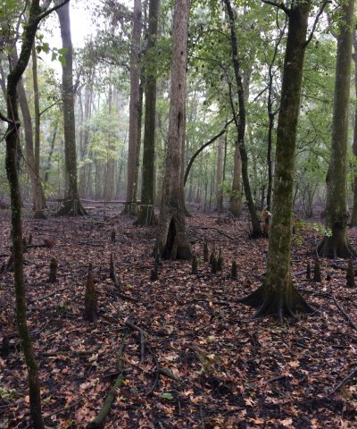
This area once consisted entirely of bottomland hardwood deciduous forests, mixed hardwood and cypress swamps. The major tree species in the native plant communities in the areas of bottomland hardwoods formerly were and currently are water oak, Nuttall oak, cherrybark oak, native pecan, red maple, sweetgum, eastern cottonwood, and hickory. The major tree species in the native plant communities in the swamps formerly were and currently are bald cypress, water tupelo, water oak, green ash, red maple, and black willow. The important native understory species are palmetto, greenbrier, wild grape, and poison ivy in the areas of bottomland hardwoods and buttonbush, lizardtail, waterlily, water hyacinth, sedges, and rushes in the swamps.
Some of the major wildlife species in this area are white-tailed deer, feral hogs, red fox, coyote, rabbit, gray squirrel, American alligator, water turtles, water snakes, frogs, otters, beavers, armadillo, crawfish, wild turkey, mourning doves, ducks, and geese. Fishing is mainly in oxbow lakes, rivers, and bayous. The species of fish in the area include largemouth bass, smallmouth bass, catfish, drum, bluegill, gar, and yellow perch.
Classification relationships
Major Land Resource Area (MLRA) and Land Resource Unit (LRU) (USDA-NRCS, 2006) MLRA 131A Southern Mississippi River Alluvium
EPA Level IV Ecoregion in sub-sections 73a - Northern Holocene Meander Belts, portions of 73d - Northern Backswamps, portions of 73k - Southern Holocene Meander Belts, portions of 73l - Southern Pleistocene Valley Trains and portions of 73m - Southern Backswamps.
The Natural Communities of Louisiana - (Louisiana Natural Heritage Program - Louisiana Department of Wildlife and Fisheries) - Cypress Swamp & Cypress-Tupelo Swamp
Foti, et al. 2011. Potential Natural Vegetation of the Mississippi Alluvial Valley Tensas Basin - Not a direct one to one relationship between concepts and PNV Classification, however PNV concepts are very useful in informing the site concepts. This site is similar to the "Depressional" and "Fringe" PNV designations.
Ecological site concept
The concept for this site is wetland forests occurring on abandoned oxbow and swale positions in backswamps (depressional areas of floodplains between natural levees), which are frequently flooded for long periods. Soil inundation and saturation are the major drivers on this site. These are very deep, very poorly drained, slowly permeable soils that formed in alluvium on level, nearly level to concave slopes in the Southern Mississippi Valley Alluvium. Slopes range from 0 to 1 percent.
This site will cover a range of conditions from standing water to the dry edges of ponded depressions. Over time, the species composition will change within the same location and may become colonized by less wet tolerant species. These changes occur for various reasons, including sedimentation of the depressions, reduced ponding if outlet is eroded, and reduced inflow of surface water as drainage patterns change.
This site concept is the wettest on the landscape and is often associated with standing water, but it may become very dry at times. As an alluvial site it received parent material soil from flooding. Hydrology is a major driver of this site concept, however it has been disconnected from the Mississippi River influence. There may be inflow into this site from local waterways, and backwater flooding may occur as part of the hydrologic regime. Due to the protection levee system this site will no longer receive direct inflows from the Mississippi River. In the event of a catastrophic failure of the levee system, this area would be impacted by direct flows from the Mississippi River. Of note, this site occurs on the “protected” side of the extensive Mississippi River levee system and is distinguished from similar landforms within the “batture lands” (i.e., the alluvial land between the river channel and the constructed levee system).
Associated sites
| F131AY402LA |
Tensas Basin - Poorly Drained Backswamp Will be found higher on the landscape than this site, is better drained, and there will be a gradual transition between the sites. |
|---|
Similar sites
| F131AY501LA |
Delta Plain - Frequently Flooded Ponded Very Poorly Drained Oxbows and Swales Is a similar site in a similar landscape position. The difference is the Delta Basin site is found south of the Red River in the Mississippi River Alluvium and this site is found further north. At the provisional level, there may be some need to utilize the Delta Basin site description in the Southern extent of this site. |
|---|---|
| F131AY301MS |
Yazoo - Frequently Flooded and Ponded Oxbow and Swale Forest Is a similar site in a similar landscape position. The difference is the Yazoo Basin site is found east of the Mississippi River in the Mississippi River Alluvium and this site is found to the west of the river. At the provisional level, there may be some need to utilize the Yazoo Basin site description for additional information |
| F131AY105AR |
Western Lowlands - Frequently Flooded and Ponded Oxbow and Swale Forest Is a similar site in a similar landscape position. The difference is the Western Lowlands site is found north of the of the Arkansas River in the Mississippi River Alluvium and this site is found further south. At the provisional level, there may be some need to utilize the Western Lowlands site description for additional information |
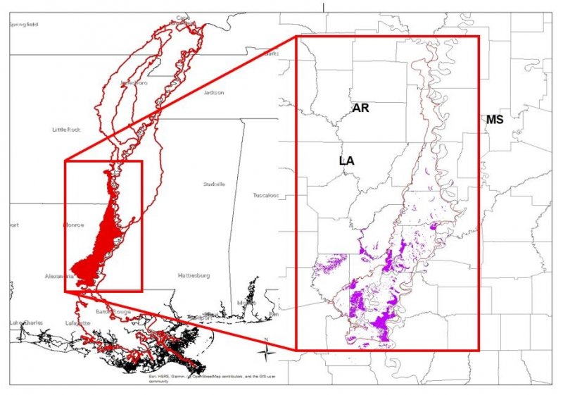
Figure 1. 131AY401 ES Extent Map
Table 1. Dominant plant species
| Tree |
(1) Taxodium distichum |
|---|---|
| Shrub |
Not specified |
| Herbaceous |
Not specified |
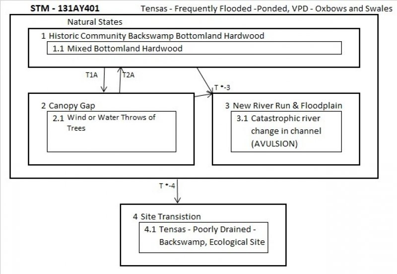
Click on box and path labels to scroll to the respective text.
Ecosystem states
| T1A | - | Wind or water Force causing canopy gaps. |
|---|---|---|
| T*-3 | - | Avulsion - Change in river or channel course. |
| T *-4 | - | Sediment accumulation, reduced flooding, improved drainage. |
| T2A | - | Regeneration of Bottom Land Hardwoods species. |
| T *-3 | - | Avulsion - Change in river or channel course |
| T *-4 | - | Sediment accumulation, reduced flooding, improved drainage. |