Ecological dynamics
Information contained in this section was adapted from several sources. The information presented is representative of very complex vegetation communities. Key indicator plants, animals, and ecological processes are described to help inform land management decisions. Plant communities will differ across the MLRA because of the naturally occurring variability in weather, soils, and hydrology. The reference plant community is not necessarily the management goal. The species lists are representative and are not botanical descriptions of all species occurring, or potentially occurring, on this site. They are not intended to cover every situation or the full range of conditions, species, and responses for the site.
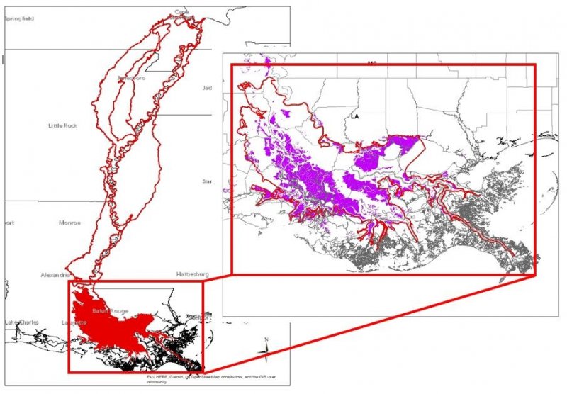
This site is found in the Delta Basin of MLRA 131A which is in the Mississippi Alluvial Plain Section of the EPA Ecoregions in sub-sections 73n - Inland Swamps, portions of 73k - Southern Holocene Meander Belts and portions of 73m Southern Backswamps. The dissected plains in this portion of the MLRA have mixed soil minerology with influences from the majority of the Drainage Area of the Mississippi River.
The historic forests of this region once consisted entirely of bottomland hardwood deciduous forests, mixed hardwood, and cypress swamps. The major tree species in the native plant communities in the areas of bottomland hardwoods formerly were and currently are water oak, Nuttall oak, cherrybark oak, native pecan, red maple, sweetgum, eastern cottonwood, and hickory. The major tree species in the native plant communities in the swamps formerly were and currently are cypress, water tupelo, water oak, green ash, red maple, and black willow. The important native understory species are palmetto, greenbrier, wild grape, and poison ivy in the areas of bottomland hardwoods and buttonbush, lizard's tail, waterlily, water hyacinth, sedges, and rushes in the swamps. Land cover in many portions are now in farms, which produce mainly cash crops. Cotton, soybeans, milo, and corn are the main crops, and sugarcane is a major crop in the southernmost part of the area. Transitions from the Alluvial Plain into the adjacent Loess is abrupt in most places and is marked by Loess bluffs to the east and west of the MLRA.
The majority of the MLRA has been converted to agricultural production; minimal areas contain stands of historic plant communities, and many of these areas that have native vegetation has had significant hydrologic alteration. At the northern end of this sub-region of the MLRA, where the Red River, Atchafalaya River and Mississippi River converge are the Old River Control Structures. These structures are operated to maintain the distribution of flow between the Mississippi River and the Atchafalaya River, and also prevent the Atchafalaya River from capturing the flow of the Mississippi River. The Lower Atchafalaya Basin Floodway System is located within the bounds of this sub-region of the MLRA and includes six requirements: water management, recreation, public access, environmental protection, flood control, and water circulation/canal closure. The flood control component provides safety and livelihood protection to the surrounding communities; it limits the natural reach of the Mississippi River during overbank flow.
As mentioned previously this sub-region's northern extent is found at the Old River Control Structures which regulate the flows of the Mississippi, Red, and Atchafalaya Rivers. Additional components in the system are the river levee systems which further regulate the flows and flooding of these river systems. These constructed constraints to the system have substantially altered the hydrologic functions of the sites found within the whole of MLRA 131A. Unprotected areas within the confines of the levee systems have increased frequency, duration, depth, and force of flooding. Protected areas outside of the levee systems have reduced total flooding other than catastrophic events. These hydrologic alterations have changed ecological sites within the MLRA to where attempts at describing historic communities are best scientific concepts, so most sites are described based on current regimes. The current Atchafalaya River was initiated in the 18th century and by 1765 was well established and in 1831 the Shreve cutoff, near the location of the Old River Control Structure, minimized the flow between the Mississippi River and the Atchafalaya River. These natural and anthropogenic hydrologic impacts have occurred within the timeframe that is considered to define the Historic Community of the site, so the transitions between ecological states and other ecological sites are very dynamic.
This sub-region of the MLRA has its southernmost portion being positioned at the gulf and it is influenced by tidal forces. The Mississippi River built this landscape through its multiple meandering channel belts and sediment deposition. The geologic development of coastal Louisiana is closely related to shifting Mississippi River courses. The Mississippi River has changed its course several times during the last 7,000 years, leading to the development of the Mississippi River Deltaic and Chenier Plains. The Delta Plain is comprised of six major delta complexes, two of which are prograding and four are degrading. Recognition that the Delta Plain is formed by an orderly progression of events related to shifting Mississippi River courses led to the identification and characterization of the deltaic cycle. The delta cycle is a dynamic and episodic process alternating between periods of seaward progradation of deltas (regressive deposition) and the subsequent landward retreat of deltaic headlands as deltas are abandoned, reworked, and submerged by marine waters (transgressive deposition). Within these shifts in land building and subsiding the complexity of the ecological sites are realized, with transitions from the alluvial landscape of MLRA 131A to the marshes of MLRA 151. These close relationships and transitions between the alluvial landscape and the marsh landscape provides a gradual transition found in the southern most portion of the MLRA which is almost obscured. For the purposes of describing ecological sites, MLRA 131A sites are confined to those that are regarded as historically containing forested conditions and those that were historically dominated by herbaceous marsh species are considered MLRA 151 ecological sites.
This site is described as wetland forests occurring on oxbow and swale positions in backswamps, which are frequently flooded and ponded for long periods. Soil inundation and saturation is a major driver on this site as these soils are very deep, very poorly drained, slowly permeable clayey soils that rarely dry out. The level (0 to 2 percent), linear to concave-shaped slopes create water-receiving, rather than water-shedding, landform positions that hold water for most of the year (excepting artificial drainage).
This site will cover a gradient from standing water to dry edges of ponded conditions. Over time the species gradient will change within the same location and may become colonized by less wet tolerant species. These changes occur for various reasons, including sedimentation of the lows, reduced ponding if outlet is eroded, and reduced inflow of surface water as drainage patterns change. This site concept is the wettest on the landscape and is often associated with standing water, however it may become very dry at times.
Of note, this site occurs on the “protected” side of the extensive Mississippi River levee system and is distinguished from similar landforms within the “batture lands” (i.e., the alluvial land between the river channel and the constructed levee system). Some locations of this site will receive Mississippi River flood waters at times within the Atchafalaya Floodway system; this is similar to the flooding that would have been received historically, however the frequency will be altered due to control structures and management.
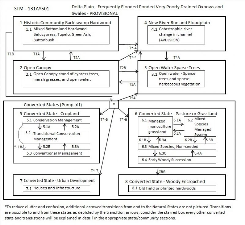
State 1
Historic Community Backswamp Hardwood
Mixed Bottomland Hardwood - Baldcypress, Tupelo, Green Ash, Buttonbush
Community 1.1
Mixed Bottomland Hardwood
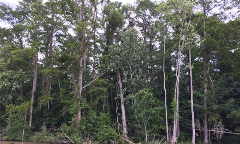
Figure 10. 131AY501-Ponded-Backswamp
Baldcypress, Tupelo, Green Ash, Buttonbush
State 2
Open Canopy
Open Canopy stand of cypress trees, marsh grasses, and open water.
Community 2.1
Open Canopy stand of cypress trees, marsh grasses, and open water.
Open Canopy stand of cypress trees, marsh grasses, and open water.
State 3
Open Water Sparse Trees
Open water - Sparse trees and sparse herbaceous vegetation.
Community 3.1
Open water - Sparse trees and sparse herbaceous vegetation
Sparse trees and sparse herbaceous vegetation.
State 4
New River Run & Floodplain
Catastrophic river change in channel (AVULSION)
When the river changes courses, which is caused by multiple factors, this site will be affected in potentially many ways. This site may become the location of the new channel when the river re-occupies and older course or that of another river. Conversely when the river changes course and abandons previous backswamps the site may lose sediment and water inputs and become drier, which will allow the fluid sediments to consolidate.. This State potentially has more phases compared to all other Ecological Site states in this sub region.
Community 4.1
Catastrophic river change in channel (AVULSION)
When the river changes courses, which is caused by multiple factors, this site will be affected in potentially many ways. This site may become the location of the new channel when the river re-occupies an older course or that of another river. Conversely when the river changes course and abandons previous backswamps the site may lose sediment and water inputs and become drier, which will allow the fluid sediments to consolidate. This state potentially has more phases compared to all other ecological site states in this sub region.
State 5
Converted State - Cropland
This site is generally considered not suited for crop production due to flooding and wetness. When the site hydrology has been altered mechanically by the construction of levees, water control structures, and potentially pumps, crop species may be established, and the site utilized for production. Maintenance of the hydrologic control must be continued to maintain production and if control is abandoned or lost, site conditions may return to excessively wet conditions which will prevent utilization of the land for crop production. Conditions even with control may only allow production on an irregular basis.
This state represents a crop production field. Annual plantings for forage production would also be included in this phase, which may include cool-season annual grasses and legumes and warm-season forage species. Vegetable crops are grown on this site and are generally on a small scale. Sugarcane, corn, and soybeans are dominant crops and can be planted in fields with adequate management. Wheat may be included in the rotation or as a standalone crop. Other row crop species have been produced on these sites. Often two or more crops will be grown in a multiyear rotation, this breaks pest cycles and some crops produce higher amounts of residue, which is left on the soil to improve soil health. Maintenance of monoculture crop stands also requires the control of unwanted species, which will require pest management and nutrient management to maintain the needed fertility for production of the desired species. Refer to E-Field Office Technical Guide (EFOTG) and the local NRCS Field Office for management assistance.
Dominant resource concerns
-
Sheet and rill erosion
-
Ephemeral gully erosion
-
Classic gully erosion
-
Bank erosion from streams, shorelines, or water conveyance channels
-
Subsidence
-
Compaction
-
Organic matter depletion
-
Aggregate instability
-
Nutrients transported to surface water
-
Nutrients transported to ground water
-
Pesticides transported to surface water
-
Pesticides transported to ground water
-
Plant productivity and health
-
Plant pest pressure
Community 5.1
Conservation Management
This cropland phase utilizes long term continuous conservation management systems including reduced till and cover crops, no-till with cover crops, and perennial cropping systems. Indicators of these systems take place in the soil and impacts how it functions; the state change can only be quantified using soil health indicator tests. The above-ground Crop growth is not the best tracking mechanism for this phase. Implementation of tillage even after long term no-till will reset the system back to conventional cropping systems, however returning to a conservation management system is achievable. There are instances where due to climatic conditions in a given crop year, tillage may be considered and/or needed to repair previous damage. These instances should be considered critically prior to implementing tillage if the desired outcome is aesthetics opposed to production.
Critical conservation practices associated with this phase include Cover Crops, No-Till, and Reduced Till as the bedrock practices. There could also be associated supporting and site- specific practices that are needed to address specific conservation needs in a given management unit.
Community 5.2
Transitional Conservation Management
This cropland phase is a common scenario and could be in a continuous ‘transitional’ phase of conservation management state forever. Getting past years 1 and 2 will reduce the need to apply pesticides that call for bare soil for activation. Sugarcane is the most common perennial crop that would be a continuous transitional phase where intense tillage is implemented at the time of planting and then reduced tillage during the rotation. Planted forage crops could also be included in this phase when part of a crop rotation, as well as when part of a rotation where reduced tillage is implemented for one crop and then tillage is utilized for another crop in the rotation.
Conservation practices are included with this phase and include nutrient management, pest management, reduced till, strip till and the inclusion of cover crops. There could also be associated supporting and site-specific practices that are needed to address specific conservation needs in a given management unit.
Dominant resource concerns
-
Sheet and rill erosion
-
Ephemeral gully erosion
-
Classic gully erosion
-
Subsidence
-
Compaction
-
Organic matter depletion
Community 5.3
Conventional Management
This cropland phase is typical conventional cropland where tillage is implemented as an annual part of the production system. When conventional annual tillage is part of the production system sugarcane is placed with conventional annual cropping. This system is productive and will require the utilization of conservation practices such as nutrient and pest management to address fertility needs and pest concerns within the crop production cycle. This phase may occur when tillage is implemented to address damage due to climatic conditions during a previous crop cycle in a conservation management system and the intention is to return to the conservation management system.
There could also be associated, supporting, and site-specific practices that are needed to address specific conservation needs in a given management unit. Specific needs may include grade stabilization structures to control gully erosion, grassed waterways to trap sediment from sheet and rill erosion, or reduced till.
Dominant resource concerns
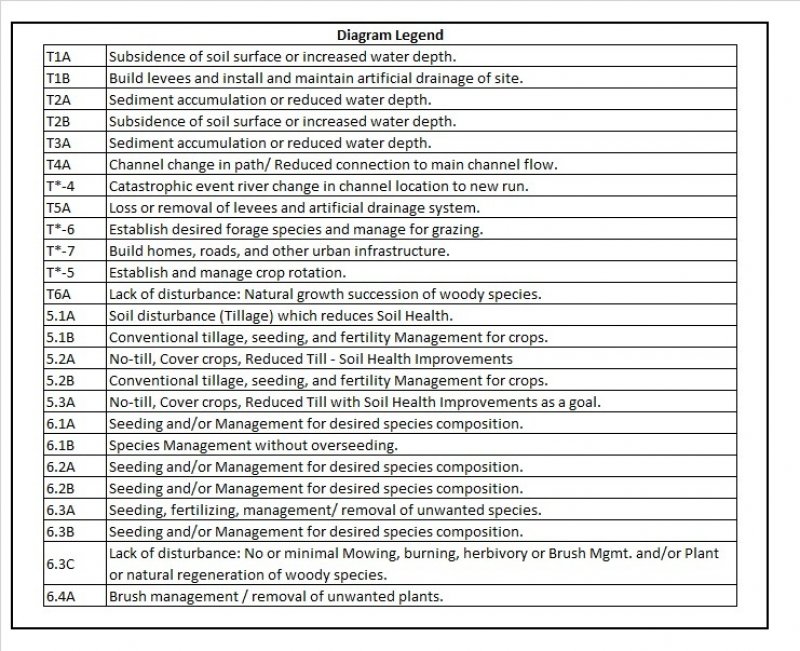
Pathway 5.1A
Community 5.1 to 5.2
Soil disturbance (tillage) which reduces Soil Health.
Pathway 5.1B
Community 5.1 to 5.3
Conventional tillage, seeding, and fertility management for crops.
Pathway 5.2A
Community 5.2 to 5.1
Soil health Improvements - no-till, cover crops, reduced tillage. This transition will require soil health testing to determine reaching the conservation management phase and achieving this level of continuous soil health improvements.
Pathway 5.2B
Community 5.2 to 5.3
Conventional tillage, seeding, and fertility management for crops.
Pathway 5.3A
Community 5.3 to 5.2
Soil health improvements - no-till, cover crops, reduced tillage. This transition will require soil health testing to determine reaching the conservation management phase and achieving this level of continuous soil health improvements.
State 6
Converted State - Pasture or Grassland
This site is generally considered not suited for grazing due to flooding and wetness. When the site hydrology has been altered mechanically by the construction of levees, water control structures, and potentially pumps, forage species may be established, and the site utilized for grazing. Maintenance of the hydrologic control must be continued to maintain production and if control is abandoned or lost, site conditions may return to excessively wet conditions which will prevent utilization of the land for forage production. Conditions even with control may only allow forage production on an irregular basis. Additionally, adjacent higher elevation areas or protected areas may be needed for the storage of harvested forage or holding of livestock when wet or flooded conditions occur. Some forage operations on this site may experience none to multiple extreme wetness events in a single year that will require preplanning and resources to meet the needs of the livestock.
This state is characterized by a monoculture or a mixture of forage species planted or allowed to establish from naturalized species managed for forage production or as herbaceous ground cover.
Community 6.1
Managed monoculture grassland
Typically, this phase is characterized by planting forage species for hay production. Forage plantings generally consist of a single grass species. Introduced native and/or non-native forage species can be seeded. Forage is usually harvested as hay or haylage, although grazing may occur periodically. These sites are highly productive for forage and can provide ecological benefits to control soil erosion. Allowing for adequate rest and regrowth of desired species is required to maintain productivity. Maintenance of monoculture stands also requires control of unwanted species which will require pest management and nutrient management to maintain the needed fertility for the production of the species.
Generally, the application of fertilizer and lime is needed to establish and maintain improved desirable pastures. The exception to this is bahiagrass and common Bermudagrass, which can be sustained under natural fertility and pH levels. Introduced legumes require higher pH, phosphorus, and potassium levels than most grasses. Introduced grasses, such as hybrid bermudagrass, require a higher level of sustained fertility, maintain pH above 6.0, and good surface drainage, to persist. Implementation of prescribed grazing of grass species with a specific goal of growing roots deeper in the soil profile, in order to tap into the reservoir of available nutrients and moisture, to increase production, and sustain desirable forages.
Conservation practices should include prescribed grazing, or forage harvest management, nutrient and pest management, and other site-specific facilitating practices.
Dominant resource concerns
-
Plant productivity and health
-
Plant structure and composition
-
Feed and forage imbalance
Community 6.2
Mixed Species Managed System
This community is characterized by mixed species composition of grasses and legumes, which is planted or naturally establishes. Typically, perennial warm-season grasses are the foundation of the stand which is periodically over seeded with adapted cool-season forages to extend the grazing season. This community phase can be highly productive for grazing and haying operations and can provide beneficial habitat for some wildlife species.
Maintenance of grass stands also requires a collection of management practices such as prescribed grazing, brush management, pest management, and nutrient management to maintain the production of the desired species. Prescribed grazing includes maintaining proper grazing heights, timing, and stocking rates. Supporting or facilitating practices including fences, water lines, and watering facilities could be part of the system that maintains this phase.
Community 6.3
Mixed Species, Non-seeded
This community is characterized by a stand where mixtures of native and naturalized non-native species occur, this could also include abandonment of cropping (i.e., idle cropland that is not being utilized for forage production). This state represents low inputs after cropping, no initial seeding of pasture species or periodic over seeding of adapted forage species. Forage is usually grazed and/or harvested as stored forage, hay, or haylage. Common established species may include Bermudagrass, bahiagrass, Vasey’s grass, and carpet grass. This phase is productive, forage and grazing management can maintain forage stands and protect soils from excessive runoff and erosion. A common peril associated with this phase is overgrazing which favors less productive and less palatable weedy species, especially in areas where livestock congregate. Proper stocking rates and/or grazing systems that allow for adequate rest and plant regrowth are required to maintain productivity.
When forage species are afforded adequate recovery time between grazing intervals, they will develop deeper root systems and greater leaf area allowing for the capture of greater solar energy, where photosynthesis fixes carbohydrates for plant growth. Conversely, when plants are not allowed to recover adequately, root development will be restricted, and forage and biomass production will be reduced. Maintenance of grass stands also requires pest management for control of unwanted weedy and woody species.
Community 6.4
Early Woody Succession
This community is characterized by a diverse species composition of grasses and forbs with an increasing composition of woody species (native and non-native) that are immature and low stature. If this community phase is not managed, and no brush management measures are taken, the plant community will transition to the Woody Encroached State (8). Control of woody species will require input of extensive resources to return to a Grassland or Cropland state. This phase is generally limited in woody species composition and size to the point where normal agricultural equipment is no longer able to return the site to a cropland phase, by mowing or disking. When the threshold is crossed to where the stem diameter exceeds 2 to 3 inches and the percent cover exceeds 100 to 300 stems per acre, the site has transitioned to the Woody Encroached State (8).
If the restored hardwood community is desired, proper management is required. This phase can be a beneficial habitat for some wildlife species. Woody invasive species grow quickly and can be difficult and expensive to control. Some invasive woody species, such as tallow trees (Triadica sebifera), will invade and grow to produce seeds in as few as 3 years.
Dominant resource concerns
Pathway 6.1A
Community 6.1 to 6.2
Seeding and/or management for desired species composition.
Pathway 6.1B
Community 6.1 to 6.3
Species management without overseeding.
Pathway 6.2A
Community 6.2 to 6.1
Seeding and/or management for desired species composition.
Pathway 6.2B
Community 6.2 to 6.3
Seeding and/or management for desired species composition.
Pathway 6.3A
Community 6.3 to 6.1
Seeding, fertilizing, management and removal of unwanted species.
Pathway 6.3B
Community 6.3 to 6.2
Seeding and/or management for desired species composition.
Pathway 6.3C
Community 6.3 to 6.4
Lack of disturbance: No or minimal mowing, burning, herbivory or brush management, and/or planted or natural regeneration of woody species.
Pathway 6.4A
Community 6.4 to 6.3
Brush management and/or removal of unwanted plants.
State 7
Converted State - Urban development
This site is generally considered not suited for urban development due to flooding and wetness. When the site hydrology has been altered mechanically by the construction of levees, water control structures and pumps development may be possible. Maintenance of the hydrologic control must be continued and if control is abandoned or lost, site conditions may return to excessively wet conditions which will inhibit urban development on this site.
This state represents an area that has been altered to provide locations for homes, businesses, and infrastructure where people live, work, and recreate. The human population is higher than in the surrounding rural area. It is where buildings are close together and are usually considered cities and towns. This state may be found in small clusters in rural areas where multiple buildings are in close proximity with roads and infrastructure that support a rural population.
The changes to the landscape will not generally return to the historic community of Hardwood trees, however, some of this landcover may be present in areas. There are generally many introduced species and potentially invasive species located in these areas and managed as ornamentals. These non-native species should be managed to prevent infestation and invasion into other areas where they can become a problem.
Within this land use, there are expansive networks of infrastructure both above and below ground for use by the inhabitants of the area. These include roads, drainage channels and structures, electrical distribution systems, telecommunications systems, drinking water distribution systems, and many other components that contribute to the quality of human life.
Community 7.1
Houses and Infrastructure
This phase is described as homes, buildings, and infrastructure as part of an urban setting. This sub-region of the MLRA contains some fairly dense population centers, there are large cities, towns, and villages within this area. The idea of "concrete jungles" of large metropolitan centers is not typical for this phase, because many of the urbanized areas will include open spaces of semi-natural areas, gardens, and habitat for local wildlife. Areas that are typical for this site include recreational areas intermingled within the urban areas. These intermingled spaces will resemble and function very similar to other phases included within this site concept and should be referenced. This phase in this site is found where hydrology has been altered and is maintained to prevent flooding. It is common in the southern reaches of the MLRA where land area is reduced, and population density is higher.
To describe this phase requires several potential types of vegetative communities as well as many surfaces that have been altered by excavation, deposition, and covering. The range of this state could be defined by many parameters, but for this purpose is maintained as a single broad phase. Many soil properties have been altered, hydrologic functions have been altered, and most of the vegetation within this phase is gardened and may not fit the norms of the site concept. The inclusion of this phase within this ecological site description is to acknowledge its presence and direct the users to qualified professionals for any work that is planned. The infrastructure within this state of the site will include pipelines, wires, and other potential hazards which will require contact of services to locate these to prevent damage if any soil disturbing activity is planned.
State 8
Converted State - Woody Encroached
Dominant resource concerns
-
Ephemeral gully erosion
-
Classic gully erosion
-
Subsidence
-
Compaction
-
Organic matter depletion
-
Concentration of salts or other chemicals
-
Plant productivity and health
-
Plant structure and composition
Community 8.1
Old field or planted hardwoods
This phase occurs when cropland or pastureland has been allowed to naturally regenerate without succession manipulation, or when hardwoods are planted on the site. This state will have succession very different from the Open Canopy phase of the historic community due to alterations in the site's hydrology. Species composition may be very different depending on the available seed source. When this occurs from a cropland or pasture state species composition may be dominated by introduced species, but desired hardwood species can be established to regenerate the state to that desired community.
Dominant resource concerns
-
Ephemeral gully erosion
-
Classic gully erosion
-
Subsidence
-
Compaction
-
Organic matter depletion
-
Concentration of salts or other chemicals
-
Plant productivity and health
-
Plant structure and composition
Transition T1A
State 1 to 2
Subsidence of soil surface or increased water depth.
Transition T*-4
State 1 to 4
Avulsion occurs when the river changes course to a new location. When this occurs, there are major changes to both locations on the landscape as well as the hydrologic regime. The transition will cause any given location to move into potentially any of the ecological site concepts which fit the sub-region of the MLRA.
Transition T1B
State 1 to 5
Build levees and install and maintain artificial drainage of site.
Transition T1B
State 1 to 6
Build levees and install and maintain artificial drainage of site.
Transition T1B
State 1 to 7
Build levees and install and maintain artificial drainage of site.
Transition T2A
State 2 to 1
Sediment accumulation or reduced water depth.
Transition T2B
State 2 to 3
Subsidence of soil surface or increased water depth.
Transition T*-4
State 2 to 4
Avulsion occurs when the river changes course to a new location. When this occurs, there are major changes to both locations on the landscape as well as the hydrologic regime. The transition will cause any given location to move into potentially any of the ecological site concepts which fit the sub-region of the MLRA.
Transition T3A
State 3 to 2
Sediment accumulation or reduced water depth.
Transition T*-4
State 3 to 4
Avulsion occurs when the river changes course to a new location. When this occurs, there are major changes to both locations on the landscape as well as the hydrologic regime. The transition will cause any given location to move into potentially any of the ecological site concepts which fit the sub-region of the MLRA.
Transition T4A
State 4 to 3
Channel change in path. Reduced connection to main channel flow.
When a river channel is abandoned or reduced flow in the system, the Open Water Sparse Trees State begins to trap sediment and the transition pathway will turn towards the stable Backswamp Hardwoods state through the Open Canopy state.
Transition T5A
State 5 to 3
Loss or removal of levees and artificial drainage system.
Transition T*-6
State 5 to 6
Establish desired forage species and manage for grazing.
Transition T*-7
State 5 to 7
Build homes, roads, and other urban infrastructure.
Transition T5A
State 6 to 3
Loss or removal of levees and artificial drainage system.
Transition T*-5
State 6 to 5
Establish and manage crop rotation.
Transition T*-7
State 6 to 7
Build homes, roads, and other urban infrastructure.
Transition T6A
State 6 to 8
Lack of disturbance: Natural growth succession of woody species.
Transition T5A
State 7 to 3
Loss or removal of levees and artificial drainage system.
Transition T5A
State 8 to 3
Loss or removal of levees and artificial drainage system.