Natural Resources
Conservation Service
Ecological site R028AY306UT
Upland Gravelly Loam (Bonneville Big Sagebrush)
Last updated: 4/16/2025
Accessed: 10/19/2025
General information
Provisional. A provisional ecological site description has undergone quality control and quality assurance review. It contains a working state and transition model and enough information to identify the ecological site.
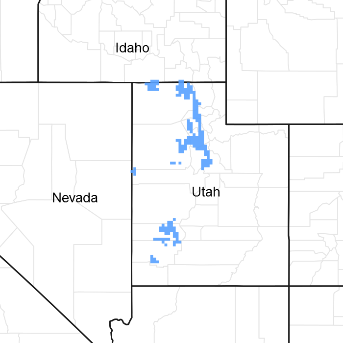
Figure 1. Mapped extent
Areas shown in blue indicate the maximum mapped extent of this ecological site. Other ecological sites likely occur within the highlighted areas. It is also possible for this ecological site to occur outside of highlighted areas if detailed soil survey has not been completed or recently updated.
MLRA notes
Major Land Resource Area (MLRA): 028A–Ancient Lake Bonneville
MLRA 28A occurs in Utah (82 percent), Nevada (16 percent), and Idaho (2 percent). It encompasses approximately 36,775 square miles (95,246 square kilometers). A large area west and southwest of Great Salt Lake is a salty playa. This area is the farthest eastern extent of the Great Basin Section of the Basin and Range Province of the Intermontane Plateaus. It is an area of nearly level basins between widely separated mountain ranges trending north to south. The basins are bordered by long, gently sloping alluvial fans. The mountains are uplifted fault blocks with steep side slopes. Most of the valleys are closed basins containing sinks or playa lakes. Elevation ranges from 3,950 to 6,560 feet (1,204 to 2000 meters) in the basins and from 6,560 to 11,150 feet (1996 to 3398 meters) in the mountains. Much of the MLRA has alluvial valley fill and playa lakebed deposits at the surface from pluvial Lake Bonneville, which dominated this MLRA 13,000 years ago. A level line of remnant lake terraces on some mountain slopes indicates the former extent of this glacial lake. The Great Salt Lake is what remains of the pluvial lake.
Mountains in the interior of this MLRA consist of tilted blocks of marine sediments from Cambrian to Mississippian age with scattered outcrops of Tertiary continental sediments and volcanic rocks. The average annual precipitation is 5 to 12 inches (13 to 30 cm) in the valleys and ranges up to 49 inches (124 cm) in the mountains. Most of the rainfall in the southern LRU occurs as high-intensity, convective thunderstorms during the growing season (April through September). The driest period is from midsummer to early autumn in the northern LRU. Precipitation in winter typically occurs as snow. The average annual temperature is 39 to 53 °F (4 to 12 °C). The freeze-free period averages 165 days and ranges from 110 to 215 days, decreasing in length with increasing elevation. The dominant soil orders in this MLRA are Aridisols, Entisols, and Mollisols. Soils are dominantly in the mesic or frigid soil temperature regime, aridic or xeric soil moisture regime, and mixed mineralogy. The soils are generally well drained, loamy or loamy-skeletal, and very deep.
LRU notes
The Basin and Range North LRU exhibits dry summers with stronger xeric patterns than the Basin and Range South LRU. Ranges in the north LRU are about 50 percent Paleozoic sedimentary/metasedimentary (limestone/quartzite dominant) and about 10 percent Tertiary volcanics. The basin floors are between 4,200 and 5,100 feet (1280 to 1554 meters) in elevation. Pinyon and juniper sites have a greater percentage of Utah juniper (Juniperus osteosperma) in the plant community than pinyon pine (Pinus edulis or monophylla). The Basin and Range North have few semidesert ecological sites with Utah juniper. Cool season grasses, such as bluebunch wheatgrass (Pseudoroegneria spicata), are dominant in the plant community, while warm season grasses are largely absent or a small component of the plant community.
Ecological site concept
The Upland Gravelly Loam (Bonneville Big Sagebrush) ecological site is located on foothill lake terraces and benches as well as areas of fans that are located above 14 inches of effective precipitation (14 to 16 inches of effective precipitation is the typical range of Bonneville big sagebrush). It is typically found in the zone between Wyoming big sagebrush (lower elevation and lower precipitation) and mountain big sagebrush (higher elevation and higher precipitation) and is a recognized hybrid between those species (Garrison et al. 2013).
Associated sites
| R028AY307UT |
Upland Gravelly Loam (Wyoming Big Sagebrush) The dominant sagebrush is Wyoming sagebrush (Artemisia wyomingensis). |
|---|---|
| R028AY309UT |
Upland Loam (Wyoming Big Sagebrush) The soil is loam, and the sagebrush is Wyoming sagebrush. |
| R028AY325UT |
Upland Shallow Loam (Black Sagebrush) This is a black sagebrush site with shallow soils. Production is much lower than the Upland Gravelly Loam (Bonneville Big Sagebrush) ecological site. |
| R028AY334UT |
Upland Stony Loam (Wyoming Big Sagebrush) Soil is a stony loam and the dominant sagebrush is Wyoming sagebrush. |
| R028AY310UT |
Upland Loam (Bonneville Big Sagebrush) North This site will occur in soils with few rock fragments. |
| R028AY312UT |
Upland Sand (Indian Ricegrass) This site will occur in soils that are coarser in texture. |
| R028AY320UT |
Upland Shallow Hardpan (Pinyon-Utah Juniper) This site will occur on shallow soils with a hardpan adjacent to the Upland Gravelly Loam (Bonneville Big Sagebrush) ecological site. |
Similar sites
| R028AB306UT |
Upland Gravelly Loam (Bonneville big sagebrush) South This site is the Basin and Range South counterpart to the Basin and Range North site. It will have more summer precipitation and more potential for warm season species in the plant community. |
|---|---|
| R028AY334UT |
Upland Stony Loam (Wyoming Big Sagebrush) The soil is stony loam and the dominant sagebrush is Wyoming sagebrush. |
| R028AY307UT |
Upland Gravelly Loam (Wyoming Big Sagebrush) The dominant sagebrush is Wyoming sagebrush. |
| R028AY066NV |
GRAVELLY LOAM 12-14 P.Z. This site is located in the Nevada portion of 28A and is similar in community dynamics. |
| R028AY310UT |
Upland Loam (Bonneville Big Sagebrush) North This site has fewer than 35 percent rock fragments in the soil and has more plant production. |
| R028AY312UT |
Upland Sand (Indian Ricegrass) The site has a coarser texture and the dominant plant group is grass. |
Table 1. Dominant plant species
| Tree |
Not specified |
|---|---|
| Shrub |
(1) Artemisia tridentata ssp. wyomingensis |
| Herbaceous |
(1) Pseudoroegneria spicata |
Physiographic features
The Upland Gravelly Loam (Bonneville Big Sagebrush) ecological site occurs on upper reaches of lake terraces, alluvial fans and upper foothills. These are mainly Bonneville Lake formation terraces. This site is found on all aspects at elevations between 4,320 and 6,000 feet. Slopes are gentle to slightly steep (1 to 10 percent). Runoff is low to medium and flooding is very rare on this site.
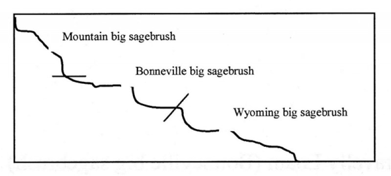
Figure 2. Catena Showing Site Position
Table 2. Representative physiographic features
| Landforms |
(1)
Alluvial fan
(2) Lake terrace (3) Hill |
|---|---|
| Flooding frequency | None |
| Ponding frequency | None |
| Elevation | 4,320 – 6,000 ft |
| Slope | 1 – 10% |
| Aspect | Aspect is not a significant factor |
Climatic features
The climate is characterized by warm, dry summers, cold, snowy winters and moist springs. October through May is the wettest part of the year and July to September is the driest. The effective moisture for plant growth is the 60 percent that falls during the plant dormant period, which wets the soil deeply in the spring and early summer. Warm season moisture is less effective for plant growth because summer storms are short and undependable.
Table 3. Representative climatic features
| Frost-free period (characteristic range) | 136-146 days |
|---|---|
| Freeze-free period (characteristic range) | 175-185 days |
| Precipitation total (characteristic range) | 19-22 in |
| Frost-free period (actual range) | 131-154 days |
| Freeze-free period (actual range) | 169-192 days |
| Precipitation total (actual range) | 18-23 in |
| Frost-free period (average) | 142 days |
| Freeze-free period (average) | 180 days |
| Precipitation total (average) | 21 in |
Figure 3. Monthly precipitation range
Figure 4. Monthly minimum temperature range
Figure 5. Monthly maximum temperature range
Figure 6. Monthly average minimum and maximum temperature
Figure 7. Annual precipitation pattern
Figure 8. Annual average temperature pattern
Climate stations used
-
(1) OGDEN HINKLEY AP [USW00024126], Roy, UT
-
(2) PLEASANT GROVE [USC00426919], Pleasant Grove, UT
-
(3) SPANISH FORK PWR HOUSE [USC00428119], Spanish Fork, UT
-
(4) TOOELE [USC00428771], Tooele, UT
-
(5) BOUNTIFUL-VAL VERDA [USC00420820], Bountiful, UT
Influencing water features
Due to its landscape position, the Upland Gravelly Loam (Bonneville Big Sagebrush) ecological site, is not typically influenced by streams or wetlands. It can be influenced by overland flow during heavy thunderstorms and/or during wetter spring runoff periods.
Soil features
The soils are deep and well to somewhat excessively drained. They formed in alluvium and colluvium derived from mixed parent materials. The surface layer has 12 to 35 percent rock fragments. The subsoil has 22 to 60 percent rock fragments. Available water capacity ranges from 2 to 5 inches in the upper 40 inches of soil. The soil moisture regime is xeric and the soil temperature regime is mesic.
The following soil map units may be found in the Upland Gravelly Loam (Bonneville Big Sagebrush) ecological site:
Soil Survey Area: Soil Components (Map units in parentheses)
Box Elder County, Western Part (UT601): Collard (19); Donnardo (28, 29, 43); Hupp (19)
Box Elder County, Eastern Part (UT602): Bingham (BdB, BeB, BeD); Dejarnet (DgB, DgD); Kilburn (KnC, KnD, KnE, KnF, KnG, KoB)
Davis-Weber Area (UT607): Kilburn (KbA, KbB, KbC, KcA, KFE2, KFF2, KFG2, KgB, KbC, KgD, KgE2, KIC, KIE2, KmA, KmC); Marriott (HMG2, McE2, MgD, MgE2); Steed (SbA, ScA, SdA, SeA)
Tooele Area (UT611): Abela (1); Holmes (26); Kapod (33, 34); Kilburn (36); Lakewin (37); Springmeyer (63)
Salt Lake Area (UT612): Bingham (BgA, BhA, BhB, BhC); Copperton (DPD, DPE, HDF); Knutsen (KBG, KnA, KoB, KoC, KrA, KsF2); Lakewin (LaA, LaC, LbC); Pharo (BfC); Pleasant Grove (PgB, PhB)
Utah County (UT621): Bingham (BhB, BkB, BmC, BmD); Cleverly (CrD, CsB, CsC, CsD); Dry Creek Variant (DEF); Kilburn (KNG2, KOD, KRE2); Lakewin (LaC, LaD, LcE); Pleasant Grove (PIC, PID, PmE2, PNG2)
The surveys below will need to be evaluated for inclusion in the Basin and Range South LRU:
Iron-Washington Area (UT634): Bamos (318); Manderfield (409); WYE (517)
Beaver-Cove Fort Area (UT640): Phage (PkD2); Pharo (PtD); Snake Hollow (SLD)
Table 4. Representative soil features
| Parent material |
(1)
Alluvium
–
limestone and siltstone
(2) Colluvium – shale (3) Slope alluvium – quartzite (4) Lacustrine deposits |
|---|---|
| Surface texture |
(1) Gravelly loam (2) Gravelly sandy loam (3) Stony loam |
| Family particle size |
(1) Loamy-skeletal |
| Drainage class | Well drained to somewhat excessively drained |
| Permeability class | Moderate to moderately rapid |
| Soil depth | 60 in |
| Surface fragment cover <=3" | 11 – 28% |
| Surface fragment cover >3" | 5% |
| Available water capacity (0-40in) |
1.7 – 4.9 in |
| Calcium carbonate equivalent (0-40in) |
15% |
| Electrical conductivity (0-40in) |
2 mmhos/cm |
| Sodium adsorption ratio (0-40in) |
Not specified |
| Soil reaction (1:1 water) (0-40in) |
6.6 – 8.4 |
| Subsurface fragment volume <=3" (Depth not specified) |
22 – 46% |
| Subsurface fragment volume >3" (Depth not specified) |
3 – 18% |
Ecological dynamics
The plant communities may not represent every possibility, but they are the most prevalent and repeatable plant communities. As more data is collected, some of these plant communities may be revised or removed and new ones may be added. None of these plant communities should necessarily be thought of as the “desired plant community”. According to the USDA NRCS National Range and Pasture Handbook, the desired plant community will be determined by the decision makers and will meet minimum quality criteria established by the NRCS. The main purpose for including any description of a plant community here is to capture the current knowledge and experience at the time of this revision.
The Upland Gravelly Loam (Bonneville Big Sagebrush) ecological site is dominated by perennial deep rooted cool season bunchgrasses and deep-rooted shrubs. Bonneville big sagebrush (Artemisia tridentata ssp. bonnevillensis [tridentata ssp. vaseyana x tridentata ssp. wyomingensis], antelope bitterbrush (Purshia tridentata), and Utah serviceberry (Amelanchier utahensis) are the dominant shrubs. The perennial bunchgrasses that are co-dominant with the shrubs include bluebunch wheatgrass (Pseudorogenaria spicata), slender wheatgrass (Elymus trachycaulus), western wheatgrass (Pascopyrum smithii), and Nevada bluegrass (Poa nevadensis syn. Poa secunda). These species generally have somewhat shallower root systems than the shrubs, but root densities are often as high as or higher than those of shrubs in the upper 0.5 meter but taper off more rapidly than shrubs. General differences in root depth distributions between grasses and shrubs result in resource partitioning in these shrub/grass systems.
Bonneville big sagebrush is a hybrid between Wyoming big sagebrush and mountain big sagebrush (Garrison et al. 2013). It exhibits characteristics of both parent species and is found in the ecotone between the lower elevation Wyoming big sagebrush and higher elevation mountain big sagebrush. Bonneville big sagebrush occurs in moister areas and is often found growing with bitterbrush, serviceberry (Amelanchier alnifolia) and mountain snowberry (Symphoricarpos oreophilus). While it can be difficult to separate Wyoming big sagebrush from Bonneville big sagebrush, it is important to identify this site because of the high utilization by native ungulates and birds (Winward 2004). Bonneville big sagebrush is found in a recurring pattern that can be predicted based on temperature, moisture, and elevation (Rivera et al. 2011). It is often found on Lake Bonneville terraces above the Wyoming sagebrush zone.
The Upland Gravelly Loam (Bonneville Big Sagebrush) ecological site is more productive and floristically diverse than the lower elevation Wyoming big sagebrush sites (Garrison 2006). This increase in productivity can be attributed to the increase in moisture availability due to the landscape position. Moisture used for plant growth is from water stored in the soil profile during the winter. Some precipitation may come in the summer months (June through August), it is however, an unreliable source of moisture for plant growth.
Utah juniper (Juniperus osteosperma) and singleleaf pinyon (Pinus monophylla) may be present on this site due to the proximity of the pinyon/juniper zone. The Upland Gravelly Loam (Bonneville Big Sagebrush) ecological site is vulnerable to an increase in both pinyon and juniper trees without disturbances that keep the tree densities lower (i.e. fire). Singleleaf pinyon and Utah juniper may dominate if there is adequate time without disturbances and eventually out-compete mountain big sagebrush for water and sunlight, severely reducing both the shrub and herbaceous understory (Miller et al. 2000, Lett and Knapp 2005). Bluegrasses may remain underneath trees on north-facing slopes. The potential for soil erosion increases as the Utah juniper woodland matures and the understory plant community cover declines (Pierson et al. 2010).
This ecological site has moderate resilience to disturbance and moderately low resistance to invasion (Miller et al. 2015). Resilience increases with elevation, aspect, increased precipitation, and increased nutrient availability. Long-term disturbance response may be influenced by small differences in landscape topography. Concave areas receive run-in from adjacent landscapes and consequently retain more moisture to support the growth of deep-rooted perennial grasses (i.e. bluebunch wheatgrass) whereas convex areas where runoff occurs are slightly less resilient and may have more shallow-rooted perennial grasses (i.e. squirreltail (Elymus elmoides) and muttongrass (Poa fendleriana). North slopes are also more resilient than south slopes because lower soil surface temperatures operate to keep moisture content higher on northern exposures.
Fire Ecology:
Bonneville big sagebrush has not specifically been researched regarding fire tolerance, but it is likely similar to Wyoming and mountain big sagebrush which are killed by fire, and do not resprout (Miller et al. 2013). Plant community composition after a fire is influenced by what plants were present before the fire and their densities (Miller et al. 2013). Typically, plants that are tolerant to fire will return after the fire (this also will depend on the severity of the fire). Bluebunch wheatgrass is tolerant of fire and can reestablish to pre-fire densities within 3 years. If the density of deep-rooted perennial grasses is low before the fire, they will be low after the fire (Miller et al. 2013). Post-fire recovery of Bonneville big sagebrush sites has not been research. Rabbitbrush, snowberry, serviceberry, and bitterbrush may increase after fire depending on the severity of the fire. (Miller et al. 2013). The sprouting ability of antelope bitterbrush is variable and depends on fire season, severity, and age of the plant (Zlatnik 1999). Plants younger than 5 years or older than 40 years do not sprout well (Zlatnik 1999).
The introduction of annual weedy species, like cheatgrass, may cause an increase in fire frequency and eventually lead to an annual dominated community (Miller et al. 2013). Infilling by singleleaf pinyon and Utah juniper may also occur with an extended fire return interval. Without fire or changes in management, pinyon and juniper will dominate the site and Bonneville big sagebrush will be severely reduced. The herbaceous understory will typically be reduced. The potential for soil erosion increases as the juniper woodland matures and the understory plant community cover declines. Catastrophic wildfire in juniper controlled sites may lead to an annual weed dominated site.
Livestock/Wildlife Grazing Interpretations:
Overgrazing leads to an increase in sagebrush and a decline in understory plants like bluebunch wheatgrass. Squirreltail will increase temporarily with further degradation. Invasion of annual weedy forbs and cheatgrass could occur with further grazing degradation, leading to a decline in squirreltail and an increase in bare ground. Wetter sites are more resistant to degradation and may end up having sagebrush and Sandberg bluegrass dominate the site. A combination of overgrazing and prolonged drought may lead to soil redistribution, increased bare ground, and a loss in plant production. Bonneville big sagebrush can be utilized by native ungulates and birds (Winward 2004). Bluebunch wheatgrass is moderately grazing tolerant but is very sensitive to defoliation during the active growth period (Blaisdell and Pechanec 1949, Laycock 1967, Anderson and Scherzinger 1975). Sandberg bluegrass may slow reestablishment of deeper rooted bunchgrass, increase under grazing pressure (Tisdale and Hironaka 1981) and is capable of co-existing with cheatgrass. Reduced bunchgrass vigor or density provides an opportunity for Sandberg bluegrass expansion and/or cheatgrass and other invasive species to occupy interspaces, leading to increased fire frequency and potentially an annual plant community. Depending on the season of use, the grazer, and site conditions, either Sandberg bluegrass or cheatgrass may become the dominant understory with inappropriate grazing management. For example, Daubenmire (1970) found that heavy sheep grazing favors Sandberg bluegrass, while heavy cattle grazing favors cheatgrass.
Six possible alternative stable states have been identified for this ecological site. The Reference State contains four community phases, shrub/grass dominated, shrub dominated, grass dominated, and a fire tolerant phase. The primary drivers in this state are fire, drought, and/or insect of disease. The Current Potential State is like the Reference State; however, non-native species have been introduced in the system which alters the resilience and resistance of the state. The Shrub State occurs with time and lack of disturbance and/or inappropriate grazing management. The Annual State occurs after large fires or multiple fires that promote annual invasive species dominance over native shrubs and grasses. The Tree State occurs when there has been sufficient time for junipers and/or pinyon trees to increase in density and dominate the site dynamics. The Seeded State occurs with management with seeding of deep rooted perennial bunchgrasses. Specific community phases and transitions will be described in the narratives below.
State and transition model

Figure 9. 28A306 State and Transition Model
More interactive model formats are also available.
View Interactive Models
More interactive model formats are also available.
View Interactive Models
Click on state and transition labels to scroll to the respective text
Ecosystem states
States 2, 5 and 6 (additional transitions)
State 1 submodel, plant communities
State 2 submodel, plant communities
State 3 submodel, plant communities
State 5 submodel, plant communities
State 6 submodel, plant communities
State 1
Reference State
The Reference State (1) includes the plant communities that were best adapted to the unique combination of factors associated with this ecological site prior to European settlement. The site was in a natural dynamic equilibrium with the historic biotic, abiotic, and climatic factors at the time of European immigration and settlement. The dominant aspect of the plant community is Bonneville big sagebrush and bluebunch wheatgrass. The community is made up of 55 percent grasses, 25 percent forbs, and 20 percent shrubs, on a dry weight base.
Characteristics and indicators. This state will only have native species in the plant community.
Community 1.1
Bonneville Big Sagebrush ≥ Perennial Cool-season Grasses ≥ Forbs ≥ Other Native Shrubs
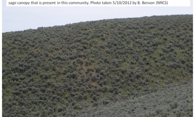
This community is described in the initial plant list. This community is represented with 55 percent grasses, 25 percent forbs, and 20 percent shrubs. The dominant shrub, visually and in production, is Bonneville big sagebrush. The dominant grass is bluebunch wheatgrass, and the dominant forb, visually, is arrowleaf balsamroot. This community has approximately 10 to 15 percent bare ground and surface rock fragments.
Figure 10. Annual production by plant type (representative values) or group (midpoint values)
Table 5. Annual production by plant type
| Plant type | Low (lb/acre) |
Representative value (lb/acre) |
High (lb/acre) |
|---|---|---|---|
| Grass/Grasslike | 200 | 950 | 1300 |
| Shrub/Vine | 150 | 500 | 810 |
| Forb | 95 | 350 | 630 |
| Total | 445 | 1800 | 2740 |
Table 6. Ground cover
| Tree foliar cover | 0-1% |
|---|---|
| Shrub/vine/liana foliar cover | 10-25% |
| Grass/grasslike foliar cover | 25-45% |
| Forb foliar cover | 15-25% |
| Non-vascular plants | 0-1% |
| Biological crusts | 0-4% |
| Litter | 10-20% |
| Surface fragments >0.25" and <=3" | 0-31% |
| Surface fragments >3" | 0-35% |
| Bedrock | 0% |
| Water | 0% |
| Bare ground | 10-20% |
Table 7. Canopy structure (% cover)
| Height Above Ground (ft) | Tree | Shrub/Vine | Grass/ Grasslike |
Forb |
|---|---|---|---|---|
| <0.5 | – | 1-1% | 8-10% | 5-8% |
| >0.5 <= 1 | – | 1-4% | 12-15% | 8-20% |
| >1 <= 2 | – | 5-10% | 20-25% | 2-5% |
| >2 <= 4.5 | – | 8-30% | 0-20% | 0-2% |
| >4.5 <= 13 | 0-1% | – | – | – |
| >13 <= 40 | – | – | – | – |
| >40 <= 80 | – | – | – | – |
| >80 <= 120 | – | – | – | – |
| >120 | – | – | – | – |
Figure 11. Plant community growth curve (percent production by month). UT3061, PNC. Excellent Condition.
| Jan | Feb | Mar | Apr | May | Jun | Jul | Aug | Sep | Oct | Nov | Dec |
|---|---|---|---|---|---|---|---|---|---|---|---|
| J | F | M | A | M | J | J | A | S | O | N | D |
| 0 | 0 | 1 | 9 | 30 | 45 | 5 | 5 | 5 | 0 | 0 | 0 |
Community 1.2
Bonneville big sagebrush ≥ Other Native Shrubs ≥ Perennial Cool Season Grasses = Forbs
This community appears when the Bonneville big sagebrush increases enough to suppress the herbaceous understory and other shrubs, such as mountain snowberry, antelope bitterbrush, and Utah serviceberry. This community has approximately 10 to 20 percent bare ground and surface rock fragments.
Community 1.3
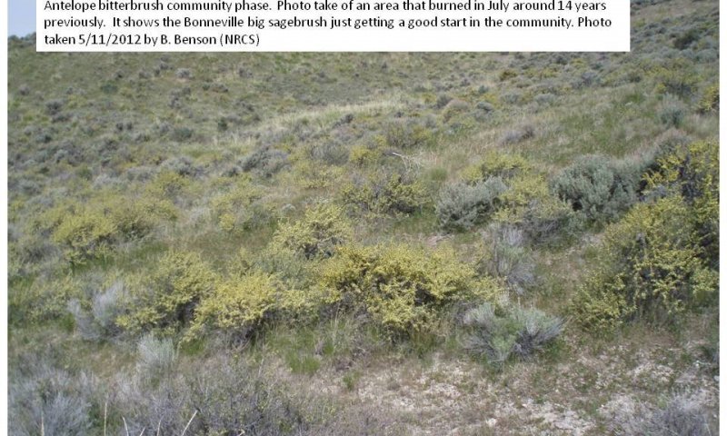
Antelope bitterbrush ≥ Perennial Cool Season Grasses ≥ Forbs ≥ Fire Tolerant Shrubs
This plant community occurs after a fire event (usually mid-temperature, fast moving fire associated with a summer convection thunderstorm. After the fire event, the Bonneville big sagebrush has been removed and replaced with antelope bitterbrush. Recovery of the Bonneville big sagebrush in this community phase may take 5 to 10 year, along with a proper episodic weather event year.
Community 1.4
Perennial Cool Season Grasses ≥ Forbs ≥ Fire Tolerant Shrubs
This community usually occurs when an intense fast-moving fire heats the ground and damages the antelope bitterbrush changing the dominant plant community. The plant community is represented with 65 percent grasses, 25 percent forbs, and 10 percent shrubs. This community will likely have approximately 15 to 20 percent bare ground and surface rock fragments.
Pathway 1.1a
Community 1.1 to 1.2
This pathway occurs over time and without a catastrophic event. This pathway may be dependent on a specific chain of climatic events.
Pathway 1.1b
Community 1.1 to 1.3
This pathway occurs during a fire event, normally in mid-summer, when the fire is hot enough, and moves fast enough to kill the sagebrush and stimulate antelope bitterbrush growth.
Pathway 1.1c
Community 1.1 to 1.4
This pathway occurs when fire, insects, prolonged drought, and/or pathogens that kill, reduce the dominant shrub overstory. Fire is the most effective of these disturbances.
Pathway 1.2a
Community 1.2 to 1.3
This pathway occurs during a fire event, normally in mid-summer, when the fire is hot enough, and moves fast enough to kill the sagebrush and stimulate antelope bitterbrush growth.
Pathway 1.2b
Community 1.2 to 1.4
This pathway occurs when fire, insects, prolonged drought, and/or pathogens that kill, reduce the dominant shrub overstory. Fire is the most effective of these disturbances.
Pathway 1.3b
Community 1.3 to 1.1
This pathway occurs over time and without a catastrophic event. This pathway may be dependent on a specific chain of climatic events.
Pathway 1.3a
Community 1.3 to 1.4
This pathway occurs when fire, insects, prolonged drought, and/or pathogens, reduce the dominant shrub overstory. Fire is the most effective of these disturbances.
Pathway 1.4a
Community 1.4 to 1.1
Time without catastrophic event. This was probably dependent on a specific chain of climatic events.
State 2
Current Potential State
The Current Potential State (2) includes the biotic communities that would become established on the ecological site if all successional sequences were completed without human interference under the present environmental conditions. Natural disturbances are inherent in its development. This State may include acclimatized, naturalized, or invasive non-native species. There is no known way to effectively remove these plants from the site once they have become established. The level of occurrence of these plants is such that careful management can prevent their domination of the site. This site is irreversibly changed. Plant communities within the Current Potential State (2) may be managed and used for various purposes without significant alteration in plant community composition or production. It includes all of the plant communities that exist in the Reference State (1) with the inclusion of species that are non-native to this ecological site. All of these scenarios are very interrelated and dependent on weather patterns and events as well as fire frequency and intensity. The fire interval frequency is approximately 30 to 55 years. Any set of events that are strong enough to force the plant community out of this pattern can push it over a threshold and into another ecological state.
Characteristics and indicators. This state will be similar in community composition and dynamics to the Reference State with the exception of the inclusion of non-native species.
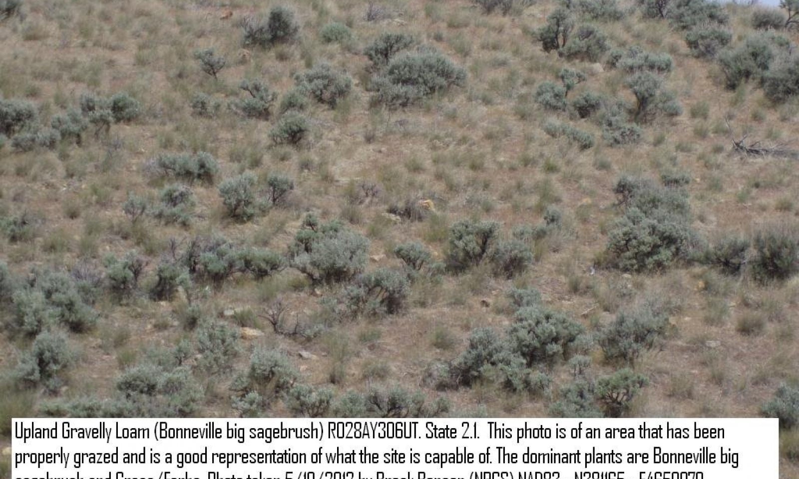
Community 2.1
Bonneville big sagebrush ≥ Perennial Cool Season Grass ≥ Forbs ≥ Other Native Shrubs ≥ Non-Native Species
This plant community is described in the initial plant list. This community is represented with 55 percent grasses, 25 percent forbs, and 20 percent shrubs. The dominant shrub, visually and in production, is Bonneville big sagebrush. The dominant grass is bluebunch wheatgrass and the dominant forb, visually, is arrowleaf balsamroot. This community has approximately 10 to 15 percent bare ground and surface rock fragments. This community has notable amounts of non-native species.
Community 2.2
Bonneville Big Sagebrush ≥ Other Native Shrubs ≥ Perennial Cool-season Grass ≥ Forbs ≥ Non-native Species
This plant community appears when the Bonneville big sagebrush increases, suppressing the herbaceous understory and other shrubs such as mountain snowberry, antelope bitterbrush, and Utah serviceberry. This community has approximately 10 to 20 percent bare ground and surface rock fragments. This community has notable amounts of non-native species.
Community 2.3
Antelope Bitterbrush ≥ Perennial Cool-season Grass ≥ Forb ≥ Fire Tolerant Shrub ≥ Non-Native Species
This plant community appears after a fire (usually a mid-temperature, fast moving fire, typically associated with summer convection thunderstorms). The Bonneville big sagebrush is replaced with antelope bitterbrush. Recovery of the Bonneville big sagebrush in this community will take approximately 5 to 10 years, along with a proper episodic weather event year. This community has notable amounts of non-native species.
Community 2.4
Perennial Cool-season Grass ≥ Forbs ≥ Fire Tolerant Shrubs ≥ Non-Native Species
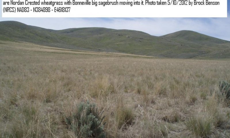
Figure 12. State 2 Community Phase 2.4: Recent burn in a healthy bluebunch wheatgrass community. Location: Portage, Utah. T14N, R4W, S1, NW1/4. Photo taken by Keith Wadman 1/9/2007
This community usually occurs after an intense fire that damages and reduces the antelope bitterbrush, The plant community is represented with 65 percent grasses, 25 percent forbs, and 10 percent shrubs. This community has notable amounts of non-native species.
Pathway 2.1a
Community 2.1 to 2.2
This pathway occurs over time and without a catastrophic event. This pathway may be dependent on a specific chain of climatic events.
Pathway 2.1b
Community 2.1 to 2.3
This pathway occurs during a fire event, normally in mid-summer, when the fire is hot enough, and moves fast enough to kill the sagebrush and stimulate antelope bitterbrush growth.
Pathway 2.1c
Community 2.1 to 2.4
This pathway occurs when disturbances such as fire, insects, prolonged drought, pathogens, and/or overgrazing reduce the dominant shrub overstory. Fire and overgrazing are the most common of these disturbances.
Pathway 2.2a
Community 2.2 to 2.3
This pathway occurs during a fire event, normally in mid-summer, when the fire is hot enough, and moves fast enough to kill the sagebrush and stimulate antelope bitterbrush growth.
Pathway 2.2b
Community 2.2 to 2.4
This pathway occurs when disturbances such as fire, insects, prolonged drought, pathogens, and/or overgrazing reduce the dominant shrub overstory. Fire and overgrazing are the most common of these disturbances.
Pathway 2.3b
Community 2.3 to 2.1
This pathway occurs over time and without a catastrophic event. This pathway may be dependent on a specific chain of climatic events.
Pathway 2.3a
Community 2.3 to 2.4
This pathway occurs when disturbances such as fire, insects, prolonged drought, pathogens, and/or overgrazing reduce the dominant shrub overstory. Fire and overgrazing are the most common of these disturbances.
Pathway 2.4a
Community 2.4 to 2.1
This pathway occurs over time and without a catastrophic event. This pathway may be dependent on a specific chain of climatic events.
State 3
Utah Juniper/Invasive Annual State
The plant community moves to the Utah Juniper/Invasive Annual State (3) when there is a lack of fire, and a source of Utah juniper and pinyon seed. The dominate aspect of the plant community is Utah juniper and cheatgrass brome. This State can persist for a long time until an extreme event such as a fire or other management treatment such as overgrazing occurs.
Characteristics and indicators. This state will have a noticeable presence of Utah juniper.
Community 3.1
Utah Juniper ≥ Bonneville Big Sagebrush ≥ Native Perennials ≥ Invasive Annuals
This community has a strong overstory of Utah juniper and singleleaf pinyon, the understory is similar to community 2.1. This community has approximately 20 to 35 percent bare ground and surface rock fragments. Fire may bring this community back toward the Current Potential State (2).
Community 3.2
Utah Juniper ≥ Invasive Annuals
This community is present when 99 percent of the native plants have been removed from the plant community and only pinyon and juniper with a sparse understory of invasive annuals remain on the site. This community has approximately 35 to 85 percent bare ground and surface rock fragments. Few native plants such as Sandberg bluegrass, may occur in this community phase.
Pathway 3.1a
Community 3.1 to 3.2
This pathway occurs due to overgrazing, with or without drought, over a prolonged period of time.
Pathway 3.2a
Community 3.2 to 3.1
This pathway occurs when disturbances such as fire, insects, prolonged drought, and/or pathogens, reduce the dominant shrub overstory. Fire is the most effective of these disturbances.
State 4
Bonneville Big Sagebrush / Broom Snakeweed State ≥ Invasive Annuals
The Bonneville Big Sagebrush/Broom Snakeweed State (4) occurs when the site is overgrazed for a prolonged period of time. Drought, fire, mechanical disturbance, and other like disturbances will speed up the process.
Community 4.1
Bonneville Big Sagebrush ≥ Broom Snakeweed ≥ Sandberg Bluegrass ≥ Invasive Annuals
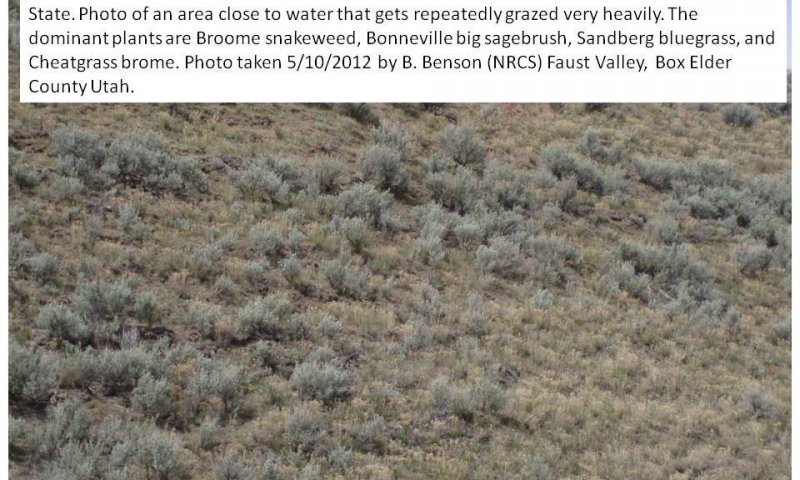
This community has approximately 35 percent Bonneville big sagebrush, 35 percent broom snakeweed, and 15 percent grass and forb. When the air dry production is considered it would approximate 35 percent Bonneville big sagebrush, 55 percent broom snakeweed, and 10 percent grasses and forbs. Most of the grasses and forbs are non-native annuals. This community has approximately 20 to 35 percent bare ground and surface rock fragments.
Community 4.2
Broom snakeweed ≥ Invasive Annuals ≥ Sandberg Bluegrass
This plant community has lost the Bonneville big sagebrush and the invasive annuals have reduced the areas of Sandberg bluegrass. The broom snakeweed controls about 75 percent of the annual production. This community has approximately 35 to 40 percent bare ground and surface rock fragments.
Pathway 4.1a
Community 4.1 to 4.2
This pathway occurs when disturbances such as fire, insects, prolonged drought, and/or pathogens, reduce the dominant shrub overstory. Fire is the most effective of these disturbances.
Pathway 4.2a
Community 4.2 to 4.1
This pathway occurs over time, when management practices such as grazing are used, as well as the introduction of native or perennial plant species.
State 5
Yellow Rabbitbrush / Invasive Annuals State
The Yellow Rabbitbrush/Invasive Annuals State (5) plant community occurs when it has been overgrazed and/or in a drought condition; and then burned (wild or controlled) and not seeded. The dominant aspect of the plant community is cheatgrass brome, yellow rabbitbrush, with a very small amount of Bonneville big sagebrush. The community will usually be made up of 70 percent cheatgrass brome, 10 percent forbs, and 20 percent yellow rabbitbrush with minor components of other shrubs.
Community 5.1
Yellow Rabbitbrush ≥ Invasive Annuals
This plant community consists of approximately 40 percent yellow rabbitbrush, 45 percent invasive annuals, and 10 percent native perennials with a small component of other species. This community has approximately 20 to 35 percent bare ground and surface rock fragments.
Community 5.2
Invasive Annuals
This plant community consists of approximately 85 percent invasive annuals (mostly cheatgrass brome and Japanese brome [also known as field brome]), and 10 percent native perennials with a small component of other species. This community has approximately 20 to 40 percent bare ground and surface rock fragments.
Pathway 5.1a
Community 5.1 to 5.2
This pathway occurs with increased fire frequency and intensity without follow-up management. Overgrazing can move this change along faster. In the Yellow Rabbitbrush/Invasive Annuals State (5) the fire interval frequency will remain at 3 to 5 years. This condition is self-sustaining and the site will keep deteriorating until the site potential is lost.
Pathway 5.2a
Community 5.2 to 5.1
This pathway occurs over time, when management practices such as grazing are used, as well as the introduction of native or perennial plant species.
State 6
Seeded Range State
The Seeded Range State (6) exists when the site is cultivated and/or burned, and then planted to introduced and/or native grasses and forbs.
Characteristics and indicators. This state consists of predominantly non-native seeded range species.
Community 6.1
Introduced Perennial Plants
The plant community consists of introduced and/or native grasses and forbs. Productivity levels may compare to the productivity levels in the Current Potential State (2).
Community 6.2
Native Shrubs = Introduced Perennial Plants
This plant community develops when weather conditions create the kind of episodic situation that allows Bonneville big sagebrush to move back onto the site.
Pathway 6.1a
Community 6.1 to 6.2
This pathway occurs over time, and without a catastrophic event. This may be dependent on a specific chain of climatic events.
Pathway 6.2a
Community 6.2 to 6.1
This pathway occurs over time, and when management practices such as grazing are used, as well as other disturbances where human intervention takes place to move the community back.
Transition T1a
State 1 to 2
This transition occurs when there is an introduction of non-native species into the ecosystem.
Transition T1b
State 1 to 4
This pathway occurs when disturbances such as fire, insects, prolonged drought, pathogens, and/or overgrazing reduce the dominant shrub overstory. Fire and overgrazing are the most common of these disturbances.
Transition T2a
State 2 to 3
This transition takes place when the sagebrush canopy has increased so it destroys the perennial grass and forb understory and the fire interval frequency increases to 60 to 90 years from an average of 20 to 40 years. Disturbances such as prolonged drought, overgrazing, and extreme lengthening of the fire interval frequency contribute to the introduction of Utah juniper on to the site.
Transition T2b
State 2 to 4
This transition occurs due to prolonged drought and/or prolonged overgrazing.
Transition T2c
State 2 to 5
This transition occurs due to continued overgrazing and an increase of fire frequency over a prolonged period of time.
Transition T3b
State 3 to 5
This transition occurs due to continued overgrazing and an increase of fire frequency over a prolonged period of time.
Transition T3a
State 3 to 6
This transition occurs due to disturbances caused by humans such as mechanical treatment and seeding, and/or chemical treatment and seeding.
Transition T4a
State 4 to 6
This transition occurs due to disturbances caused by humans such as mechanical treatment and seeding, and/or chemical treatment and seeding.
Transition T5a
State 5 to 6
This transition occurs due to disturbances caused by humans such as mechanical treatment and seeding, and/or chemical treatment and seeding.
Restoration pathway R6a
State 6 to 2
This restoration pathway takes approximately 25 to 50 years. Time, along with proper management that favors the native plants may return them to the site. The time frame depends on management and on the precipitation amounts. If the site is at the 15- to 16-inch precipitation zone it will respond quicker than at the 14-inch zone. Proper grazing management along with rest periods for the site may reduce the time it takes the restoration process.
Conservation practices
| Prescribed Grazing | |
|---|---|
| Grazing Management Plan - Applied |
Transition T6a
State 6 to 3
This transition takes place when the sagebrush canopy is so heavy that it destroys the perennial grass and forb understory and the fire interval frequency increases to 60 to 90 years from an average of 20 to 40 years. Prolonged drought, overgrazing, and extreme lengthening of the fire interval frequency are disturbances that contribute to the introduction of Utah juniper to the site.
Additional community tables
Table 8. Community 1.1 plant community composition
| Group | Common name | Symbol | Scientific name | Annual production (lb/acre) | Foliar cover (%) | |
|---|---|---|---|---|---|---|
|
Shrub/Vine
|
||||||
| 1 | Primary Shrubs | 200–700 | ||||
| Bonneville big sagebrush | ARTRB3 | Artemisia tridentata ssp. ×bonnevillensis | 145–330 | – | ||
| antelope bitterbrush | PUTR2 | Purshia tridentata | 95–260 | – | ||
| Utah serviceberry | AMUT | Amelanchier utahensis | 95–260 | – | ||
| 3 | Secondary Shrubs | 60–260 | ||||
| Shrub (>.5m) | 2SHRUB | Shrub (>.5m) | 33–110 | – | ||
| yellow rabbitbrush | CHVI8 | Chrysothamnus viscidiflorus | 10–39 | – | ||
| slender buckwheat | ERMI4 | Eriogonum microthecum | 10–39 | – | ||
| rubber rabbitbrush | ERNA10 | Ericameria nauseosa | 10–39 | – | ||
| spineless horsebrush | TECA2 | Tetradymia canescens | 10–39 | – | ||
| broom snakeweed | GUSA2 | Gutierrezia sarothrae | 0–26 | – | ||
| granite prickly phlox | LIPU11 | Linanthus pungens | 5–26 | – | ||
| creeping barberry | MARE11 | Mahonia repens | 5–20 | – | ||
| pricklypear | OPUNT | Opuntia | 5–20 | – | ||
| Woods' rose | ROWO | Rosa woodsii | 5–20 | – | ||
|
Grass/Grasslike
|
||||||
| 2 | Primary Grasses | 700–1100 | ||||
| bluebunch wheatgrass | PSSP6 | Pseudoroegneria spicata | 250–400 | – | ||
| slender wheatgrass | ELTR7 | Elymus trachycaulus | 100–300 | – | ||
| western wheatgrass | PASM | Pascopyrum smithii | 100–200 | – | ||
| 1 | Secondary Grasses | 95–195 | ||||
| Grass, perennial | 2GP | Grass, perennial | 20–130 | – | ||
| Indian ricegrass | ACHY | Achnatherum hymenoides | 9–65 | – | ||
| squirreltail | ELEL5 | Elymus elymoides | 9–65 | – | ||
| thickspike wheatgrass | ELLAL | Elymus lanceolatus ssp. lanceolatus | 9–65 | – | ||
| Idaho fescue | FEID | Festuca idahoensis | 9–65 | – | ||
| needle and thread | HECOC8 | Hesperostipa comata ssp. comata | 9–65 | – | ||
| Grass, annual | 2GA | Grass, annual | 15–65 | – | ||
| basin wildrye | LECI4 | Leymus cinereus | 28–65 | – | ||
| muttongrass | POFE | Poa fendleriana | 28–65 | – | ||
| oniongrass | MEBU | Melica bulbosa | 9–39 | – | ||
| prairie Junegrass | KOMA | Koeleria macrantha | 9–39 | – | ||
| Douglas' sedge | CADO2 | Carex douglasii | 9–39 | – | ||
| Geyer's sedge | CAGE2 | Carex geyeri | 9–39 | – | ||
|
Forb
|
||||||
| 3 | Primary Forbs | 95–195 | ||||
| western yarrow | ACMIO | Achillea millefolium var. occidentalis | 28–65 | – | ||
| white sagebrush | ARLUC8 | Artemisia ludoviciana ssp. candicans | 28–65 | – | ||
| arrowleaf balsamroot | BASA3 | Balsamorhiza sagittata | 28–65 | – | ||
| tapertip hawksbeard | CRAC2 | Crepis acuminata | 28–65 | – | ||
| 2 | secondary forbs | 50–300 | ||||
| Forb, annual | 2FA | Forb, annual | 50–130 | – | ||
| Forb, perennial | 2FP | Forb, perennial | 50–130 | – | ||
| purple milkvetch | ASAG2 | Astragalus agrestis | 10–39 | – | ||
| silverleaf milkvetch | ASAR4 | Astragalus argophyllus | 10–39 | – | ||
| Beckwith's milkvetch | ASBE3 | Astragalus beckwithii | 10–39 | – | ||
| Torrey's milkvetch | ASCA9 | Astragalus calycosus | 10–39 | – | ||
| painted milkvetch | ASCE | Astragalus ceramicus | 10–39 | – | ||
| Geyer's milkvetch | ASGE | Astragalus geyeri | 10–39 | – | ||
| woollypod milkvetch | ASPU9 | Astragalus purshii | 10–39 | – | ||
| Utah milkvetch | ASUT | Astragalus utahensis | 10–39 | – | ||
| Indian paintbrush | CASTI2 | Castilleja | 10–39 | – | ||
| Anderson's larkspur | DEAN | Delphinium andersonii | 10–39 | – | ||
| twolobe larkspur | DENU2 | Delphinium nuttallianum | 10–39 | – | ||
| fernleaf biscuitroot | LODI | Lomatium dissectum | 10–39 | – | ||
| Gray's biscuitroot | LOGR | Lomatium grayi | 10–39 | – | ||
| foothill deathcamas | ZIPA2 | Zigadenus paniculatus | 10–39 | – | ||
| tailcup lupine | LUCAC3 | Lupinus caudatus ssp. caudatus | 10–39 | – | ||
| smoothstem blazingstar | MELAL3 | Mentzelia laevicaulis var. laevicaulis | 0–39 | – | ||
| lobeleaf groundsel | PAMU11 | Packera multilobata | 10–39 | – | ||
| low beardtongue | PEHU | Penstemon humilis | 10–39 | – | ||
| carpet phlox | PHHOC | Phlox hoodii ssp. canescens | 10–39 | – | ||
| longleaf phlox | PHLO2 | Phlox longifolia | 10–39 | – | ||
| sanddune wallflower | ERCAC | Erysimum capitatum var. capitatum | 5–39 | – | ||
| shaggy fleabane | ERPU2 | Erigeron pumilus | 10–39 | – | ||
| Engelmann's aster | EUEN | Eucephalus engelmannii | 10–39 | – | ||
| sticky purple geranium | GEVI2 | Geranium viscosissimum | 10–39 | – | ||
| common sunflower | HEAN3 | Helianthus annuus | 5–39 | – | ||
| showy goldeneye | HEMU3 | Heliomeris multiflora | 10–39 | – | ||
| lambstongue ragwort | SEIN2 | Senecio integerrimus | 10–39 | – | ||
| scarlet globemallow | SPCO | Sphaeralcea coccinea | 10–39 | – | ||
| narrowleaf stoneseed | LIIN2 | Lithospermum incisum | 5–39 | – | ||
| prairie flax | LILEL2 | Linum lewisii var. lewisii | 10–39 | – | ||
| granite prickly phlox | LIPU11 | Linanthus pungens | 10–39 | – | ||
| western stoneseed | LIRU4 | Lithospermum ruderale | 5–39 | – | ||
| Utah buttercup | RAJO | Ranunculus jovis | 10–26 | – | ||
| fireweed | CHANA2 | Chamerion angustifolium ssp. angustifolium | 0–26 | – | ||
| yellow spiderflower | CLLUL | Cleome lutea var. lutea | 5–26 | – | ||
| miner's lettuce | CLPEP | Claytonia perfoliata ssp. perfoliata | 10–26 | – | ||
| Rocky Mountain beeplant | CLSE | Cleome serrulata | 5–26 | – | ||
| sego lily | CANU3 | Calochortus nuttallii | 10–26 | – | ||
| nettleleaf giant hyssop | AGUR | Agastache urticifolia | 10–26 | – | ||
| tapertip onion | ALAC4 | Allium acuminatum | 10–26 | – | ||
| Nevada onion | ALNE | Allium nevadense | 10–26 | – | ||
| longstalk springparsley | CYLO | Cymopterus longipes | 10–26 | – | ||
| yellow owl's-clover | ORLU2 | Orthocarpus luteus | 0–26 | – | ||
| Nevada biscuitroot | LONE | Lomatium nevadense | 10–26 | – | ||
| Great Basin desertparsley | LOSIS | Lomatium simplex var. simplex | 10–26 | – | ||
| Macdougal's biscuitroot | LOFOM | Lomatium foeniculaceum ssp. macdougalii | 10–26 | – | ||
| manyflower stickseed | HAFL2 | Hackelia floribunda | 10–26 | – | ||
| yellow fritillary | FRPU2 | Fritillaria pudica | 10–26 | – | ||
| yellow avalanche-lily | ERGR9 | Erythronium grandiflorum | 10–26 | – | ||
| flatbud pricklypoppy | ARMUR | Argemone munita ssp. rotundata | 0–20 | – | ||
| roundspike cryptantha | CRHU2 | Cryptantha humilis | 5–20 | – | ||
| western tansymustard | DEPIH | Descurainia pinnata ssp. halictorum | 5–20 | – | ||
| scarlet gilia | IPAGA3 | Ipomopsis aggregata ssp. aggregata | 5–20 | – | ||
| flatspine stickseed | LAOC3 | Lappula occidentalis | 5–20 | – | ||
| mountain tarweed | MAGL2 | Madia glomerata | 0–20 | – | ||
| tufted evening primrose | OECAM4 | Oenothera caespitosa ssp. marginata | 5–20 | – | ||
| pale evening primrose | OEPA | Oenothera pallida | 5–20 | – | ||
| orpine stonecrop | SEDE | Sedum debile | 0–10 | – | ||
| hookedspur violet | VIADA | Viola adunca var. adunca | 1–10 | – | ||
| Nuttall's violet | VINU2 | Viola nuttallii | 1–10 | – | ||
| goosefoot violet | VIPUV2 | Viola purpurea ssp. venosa | 1–10 | – | ||
Interpretations
Animal community
Livestock Interpretation
On the Upland Gravelly Loam (Bonneville Big Sagebrush) ecological site, there is a wide diversity of plant species, but the greatest production is from grasses. This is a valuable site for grazing during spring to early fall for all kinds and classes of livestock.
Wildlife Interpretation
The Upland Gravelly Loam (Bonneville Big Sagebrush) ecological site is a part of the sagebrush steppe supporting populations of Greater Sage-grouse (Centrocercus urophasianus), Columbian Sharp-tailed Grouse (Tympanuchus phasianellus columbianus), and neotropical migratory bird species. Pygmy rabbit (Brachylagus idahoensis) may be found on deep stone free inclusions. Other wildlife using this site include Black-tail Jackrabbit, Coyote, Gold Eagle, Ravens, and Mule Deer. This is a short list of the more common species found. Many other species are present as well and migratory birds are present at certain times of the year.
Hydrological functions
The soil series in the Upland Gravelly Loam (Bonneville Big Sagebrush) ecological site are in hydrologic group B and the hydrologic curve number is 61 when the vegetation is in good condition.
Recreational uses
The Upland Gravelly Loam (Bonneville Big Sagebrush) ecological site has fair to good values for aesthetic and natural beauty. The floristic component is quite varied with a fairly large number of species of grasses, forbs, and shrubs. Hunting is fair for deer and a limited number of species of upland game birds. Potential is fair to poor for camping and picnicking due to lack of overstory shade. Birding is very popular in this site.
Wood products
There are no wood products from the Upland Gravelly Loam (Bonneville Big Sagebrush) ecological site. If the site is invaded with Utah Juniper, firewood and cedar posts may be harvested.
Other products
None
Supporting information
Inventory data references
Alma Winward, USFS Ecologist, Northern Region (retired), personal communication
Sagebrush of Colorado by Alma H. Winward, 2004
Type locality
| Location 1: Tooele County, UT | |
|---|---|
| Township/Range/Section | T2S R3W SSW 19 |
| General legal description | Type Location: SW ¼, SW ¼, Section 19, Township 2S, Range 3W |
Other references
Anderson, E. W. and R. J. Scherzinger. 1975. Improving quality of winter forage for elk by cattle grazing. Journal of Range Management:120-125.
Blaisdell, J.P. and J.F. Pechanec. 1949. Effects of herbage removal at various dates on vigor of bluebunch wheatgrass and arrowleaf balsamroot. Ecology 30(3):298-305.
Daubenmire, R. 1970. Steppe Vegetation of Washington. 131 pp.
Garrison, H. 2006. Study of a putative hybrid taxon in the Artemisia tridentata complex. Master’s thesis, College of Natural Resources, Utah State University, Logan, UT.
Garrison, H. D., L. M. Shultz, and E. D. McArthur. 2013. Studies of a new hybrid taxon in the Artemisia tridentata (Asteraceae: Anthemideae) complex. Western North American Naturalist 73(1):1-19.
Laycock, W. A. 1967. How heavy grazing and protection affect sagebrush-grass ranges. Journal of Range Management:206-213.
Lett, M. S., and A. K. Knapp. 2005. Woody plant encroachment and removal in mesic grassland: Production and composition responses of herbaceous vegetation. American Midland Naturalist 153:217-231.
Miller, R.F., J.C. Chambers, D.A. Pyke, F.B. Pierson, and C.J. Williams. 2013. A review of fire effects on vegetation and soils in the Great Basin Region: response and ecological site characteristics. Gen. Tech. Rep. RMRS-GTR-308. Fort Collins, CO: U.S. Department of Agriculture, Forest Service, Rocky Mountain Research Station. 126 p.
Miller, R.F., J.C. Chambers, and M. Pellant. 2015. A field guide for rapid assessment of post-wildfire recovery potential in sagebrush and pinon-juniper ecosystems in the Great Basin: Evaluating resilience to disturbance and resistance to invasive annual grasses and predicting vegetation response. Gen. Tech. Rep. RMRS-GTR-338. Fort Collins, CO: U.S. Department of Agriculture, Forest Service, Rocky Mountain Research Station. 70 p.
Miller, R. F., T. J. Svejcar, and J. A. Rose. 2000. Impacts of western juniper on plant community composition and structure. Journal of Range Management:574-585.
Pierson, F. B., C. J. Williams, P. R. Kormos, S. P. Hardegree, P. E. Clark, and B. M. Rau. 2010. Hydrologic vulnerability of sagebrush steppe following pinyon and juniper encroachment. Rangeland Ecology & Management 63:614-629.
Rivera, S., L. Schultz, A.J. Hernandez, and R.D. Ramsey. 2011. GIS ordination approach to model distribution of shrub species in northern Utah. Natural Resources and Environmental Issues 17(25):1-12.
Tisdale, E. W. and M. Hironaka. 1981. The sagebrush-grass region: A review of the ecological literature. University of Idaho, Forest, Wildlife and Range Experiment Station.
Winward, A.H. 2004. Sagebrush of Colorado: taxonomy, distribution, ecology and management. Colorado Division of Wildlife, Denver, CO.
Zlatnik, Elena. 1999. Purshia tridentata. In: Fire Effects Information System, [Online]. U.S. Department of Agriculture, Forest Service, Rocky Mountain Research Station, Fire Sciences Laboratory (Producer). Available: https://www.fs.fed.us/database/feis/plants/shrub/purtri/all.html [2018, May 10].
Contributors
G. Brock Benson
Gary Roeder, David J. Somorville
Approval
Jamin Johanson, 4/16/2025
Rangeland health reference sheet
Interpreting Indicators of Rangeland Health is a qualitative assessment protocol used to determine ecosystem condition based on benchmark characteristics described in the Reference Sheet. A suite of 17 (or more) indicators are typically considered in an assessment. The ecological site(s) representative of an assessment location must be known prior to applying the protocol and must be verified based on soils and climate. Current plant community cannot be used to identify the ecological site.
| Author(s)/participant(s) |
Jack Alexander, Range Specialist, Synergy Resource Solutions, Inc. Julia Kluck, Soil Scientist, Synergy Resource Solutions, Inc. Shane Green, State Range Specialist, Utah NRCS |
|---|---|
| Contact for lead author | Shane Green, Shane.Green@ut.usda.gov |
| Date | 02/09/2010 |
| Approved by | Jamin Johanson |
| Approval date | |
| Composition (Indicators 10 and 12) based on | Annual Production |
Indicators
-
Number and extent of rills:
No rills present. Very minor rill development may occur in sparsely vegetated areas. If rills are present, they should be widely spaced and not connected. Rill development may increase following large storm events, but should begin to heal during the following growing season. Frost heaving will accelerate recovery. Rill development will increase as site becomes steeper. -
Presence of water flow patterns:
Water flow patterns will be short (2-5’) and meandering; interrupted by plants and exposed rocks. Some evidence of erosion or deposition associated with flow patterns. Where slopes exceed 10%, water flow patterns may be longer (5–10’). -
Number and height of erosional pedestals or terracettes:
Plants may have small pedestals (1-3”) where they are adjacent to water flow patterns, but without exposed roots. Terracettes should be few and stable. Terracettes should be small (1-3”) and show little sign of active erosion. Some plants may appear to have a pedestal but rather than be formed by erosion, the only place litter accumulates and soil collects is at plant bases forming the appearance of a pedestal. -
Bare ground from Ecological Site Description or other studies (rock, litter, lichen, moss, plant canopy are not bare ground):
Bare ground from Ecological Site Description or other studies (rock, litter, lichen, moss, plant canopy are not bare ground): 10 to 30 % (10 – 15 % on slopes up to 25 % and 15 – 30 % on slopes from 25 % up) Very few if any bare spaces of greater than 1 square foot. -
Number of gullies and erosion associated with gullies:
Number of gullies and erosion associated with gullies: None to very few. Any gullies present should show little sign of active erosion and should appear stable having perennial plants growing in the bottom and on the sides. -
Extent of wind scoured, blowouts and/or depositional areas:
Very minor evidence of active wind-generated soil movement. Wind scoured (blowouts) and depositional areas are rarely present. If present they have muted features and are mostly stabilized with vegetation and/or biological crust. Gravel or desert pavement protects the site from wind scour. -
Amount of litter movement (describe size and distance expected to travel):
Most litter resides in place with some redistribution caused by water and wind movement. Very minor litter removal may occur in flow patterns and rills with deposition occurring at points of obstruction. The majority of litter accumulates at the base of plants. Some leaves, stems, and small twigs may accumulate in soil depressions adjacent to plants. Woody stems are not likely to move. On steep slopes (>30%), litter will move downhill to next obstruction. -
Soil surface (top few mm) resistance to erosion (stability values are averages - most sites will show a range of values):
. Soil surface (top few mm) resistance to erosion (stability values are averages – most sites will show a range of values for both plant canopy and interspaces, if different): 80 to 90% of this site should have soil surfaces that are stabilized by organic matter both de-compositional and incorporated (Stability Class 4). This should be observable in that water flow patterns are not scoured to where the surface is visibly smoother than soil surfaces in non flow pattern areas. -
Soil surface structure and SOM content (include type of structure and A-horizon color and thickness):
Soil surface structure and SOM content (include type and strength of structure, and A- horizon color and thickness for both plant canopy and interspaces, if different): The A horizon is varies from 5 to 18 inches thick. Color is a grayish brown gravelly loam (typical mollic colors). Structure should be granular. -
Effect of community phase composition (relative proportion of different functional groups) and spatial distribution on infiltration and runoff:
Bunchgrasses and shrubs equally important for increasing infiltration and reducing runoff. Litter plays a role in increasing infiltration and decreasing runoff. Plants provide microhabitat for seedlings, catch litter and soil, and slow raindrops and runoff. Vascular plants and/or well-developed biological soil crusts (where present) will break raindrop impact and splash erosion. Spatial distribution of vascular plants and interspaces between well-developed biological soil crusts (where present) provide detention storage and surface roughness that slows runoff allowing time for infiltration. Interspaces between plants and any well-developed biological soil crusts (where present) may serve as water flow patterns during episodic runoff events, with natural erosion expected in severe storms. When perennial grasses decrease, reducing ground cover and increasing bare ground, runoff is expected to increase and any associated infiltration reduced. Shrubs catch snow, slow wind evaporation, and provide microhabitat for seedling establishment. -
Presence and thickness of compaction layer (usually none; describe soil profile features which may be mistaken for compaction on this site):
Presence and thickness of compaction layer (usually none; describe soil profile features which may be mistaken for compaction on this site): There should be no compaction layer. The amount of gravel can make it hard to use a probe to determine this. -
Functional/Structural Groups (list in order of descending dominance by above-ground annual-production or live foliar cover using symbols: >>, >, = to indicate much greater than, greater than, and equal to):
Dominant:
bluebunch wheatgrass, Slender wheatgrass, bonneville big sagebrushSub-dominant:
Saskatoon serviceberry, antelope bitterbrush, Western wheatgrass, nevada bluegrassOther:
other grasses > other shrubs, forbsAdditional:
Functional/Structural Groups (list in order of descending dominance by above-ground weight using symbols: », >, = to indicate much greater than, greater than, and equal to): Assumed fire cycle of 20-40 years. Perennial bunchgrasses > non-sprouting shrubs > rhizomatous grasses > sprouting shrubs » annuals > invaders such as Cheatgrass brome For example, Dominants: Bonneville big sagebrush, Bluebunch wheatgrass; Sub-dominants: Slender Wheatgrass, Western wheatgrass, Antelope bitterbrush. The perennial bunchgrass about 30 to 60 %; non-sprouting shrub 10 to 20 % (composition by biomass) functional groups are expected on this site. -
Amount of plant mortality and decadence (include which functional groups are expected to show mortality or decadence):
During years with average to above average precipitation, there should be very little recent mortality or decadence apparent in either the shrubs or grasses. Some mortality of bunchgrass and other shrubs may occur during very severe (long-term) droughts. There may be partial mortality of individual bunchgrasses and shrubs during less severe drought. Long-lived species dominate site. Open spaces from disturbance are quickly filled by new plants through seedlings and reproductive reproduction (tillering). -
Average percent litter cover (%) and depth ( in):
Litter cover includes litter under plants. Most litter will be fine litter. Depth should be scattered in the interspaces and up to 1/2” under canopies. Litter cover may increase to 35-45% following years with favorable growing conditions. Excess litter may accumulate in absence of disturbance. Vegetative production may be reduced if litter cover exceeds 45%. -
Expected annual annual-production (this is TOTAL above-ground annual-production, not just forage annual-production):
Expected annual production (this is TOTAL above-ground production, not just forage production): 950 – 1100 lb./acre on slopes 20 to 45 % and 1000 to 2000 lb./acre on slopes less than 20 % under normal growing conditions. -
Potential invasive (including noxious) species (native and non-native). List species which BOTH characterize degraded states and have the potential to become a dominant or co-dominant species on the ecological site if their future establishment and growth is not actively controlled by management interventions. Species that become dominant for only one to several years (e.g., short-term response to drought or wildfire) are not invasive plants. Note that unlike other indicators, we are describing what is NOT expected in the reference state for the ecological site:
Cheatgrass, halogeton, green rabbitbrush, annual forbs, broom snakeweed, Utah juniper, purple threeawn, medusahead rye. -
Perennial plant reproductive capability:
All perennial plants should have the ability to reproduce sexually and/or asexually, except in drought years. Density of plants indicates that plants reproduce at level sufficient to fill available resource. Within capability of site there are no restrictions on seed or vegetative reproductive capacity.
Print Options
Sections
Font
Other
The Ecosystem Dynamics Interpretive Tool is an information system framework developed by the USDA-ARS Jornada Experimental Range, USDA Natural Resources Conservation Service, and New Mexico State University.
Click on box and path labels to scroll to the respective text.