Provisional. A provisional ecological site description has undergone quality control and quality assurance review. It contains a working state and transition model and enough information to identify the ecological site.
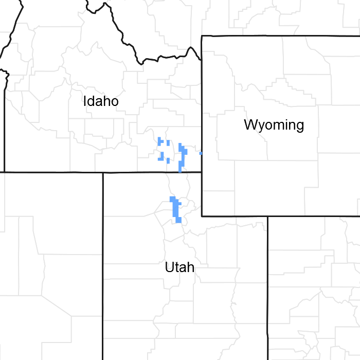
Click to explore map
Figure 1. Mapped extent
Areas shown in blue indicate the maximum mapped extent of this ecological site. Other ecological sites likely occur within the highlighted areas. It is also possible for this ecological site to occur outside of highlighted areas if detailed soil survey has not been completed or recently updated.
MLRA notes
Major Land Resource Area (MLRA): 047X–Wasatch and Uinta Mountains
MLRA 47 occurs in Utah (86 percent), Wyoming (8 percent), Colorado (4 percent), and Idaho (2 percent). It encompasses approximately 23,825 square miles (61,740 square kilometers). The northern half of this area is in the Middle Rocky Mountains Province of the Rocky Mountain System. The southern half is in the High Plateaus of the Utah Section of the Colorado Plateaus Province of the Intermontane Plateaus. Parts of the western edge of this MLRA are in the Great Basin Section of the Basin and Range Province of the Intermontane Plateaus. The MLRA includes the Wasatch Mountains, which trend north and south, and the Uinta Mountains, which trend east and west. The steeply sloping, precipitous Wasatch Mountains have narrow crests and deep valleys. Active faulting and erosion are a dominant force in controlling the geomorphology of the area. The Uinta Mountains have a broad, gently arching, elongated shape. Structurally, they consist of a broadly folded anticline that has an erosion-resistant quartzite core. The Wasatch and Uinta Mountains have an elevation of 4,900 to about 13,500 feet (1,495 to 4,115 meters).
The mountains in this area are primarily fault blocks that have been tilted up. Alluvial fans at the base of the mountains are recharge zones for the basin fill aquifers. An ancient shoreline of historic Bonneville Lake is evident on the footslopes along the western edge of the area. Rocks exposed in the mountains are mostly Mesozoic and Paleozoic sediments, but Precambrian rocks are exposed in the Uinta Mountains. The Uinta Mountains are one of the few ranges in the United States that are oriented west to east. The southern Wasatch Mountains consist of Tertiary volcanic rocks occurring as extrusive lava and intrusive crystalline rocks.
The average precipitation is from 8 to 16 inches (203 to 406 mm) in the valleys and can range up to 73 inches (1854 mm) in the mountains. In the northern and western portions of the MLRA, peak precipitation occurs in the winter months. The southern and eastern portions have a greater incidence of high-intensity summer thunderstorms; hence, a significant amount of precipitation occurs during the summer months. The average annual temperature is 30 to 50 degrees Fahrenheit (-1 to 15 C). The freeze-free period averages 140 days and ranges from 60 to 220 days, generally decreasing in length with elevation.
The dominant soil orders in this MLRA are Aridisols, Entisols, Inceptisols, and Mollisols. The lower elevations are dominated by a frigid temperature regime, while the higher elevations experience cryic temperature regimes. Mesic temperature regimes come in on the lower elevations and south facing slopes in the southern portion of this MLRA. The soil moisture regime is typically xeric in the northern part of the MLRA, but grades to ustic in the extreme eastern and southern parts. The mineralogy is generally mixed and the soils are very shallow to very deep, generally well-drained, and loamy or loamy–skeletal.
LRU notes
Major Land Resource Unit 47A is located in the northern half of the Middle Rocky Mountains Province of the Rocky Mountain System. This MLRA includes the Wasatch Mountains which tend to run north and south. These steeply sloping, precipitous mountains have narrow crests and deep valleys. They are primarily fault blocks that have been tilted up. The alluvial fans located at the base of these mountains are important recharge zones for valley aquifers.
Ecological site concept
The soils in this site formed in colluvium derived from limestone, sandstone, shale and various igneous rocks. They are moderately deep to deep, well-drained and have dark-colored surface layers that constitute a mollic epipedon. Rock fragments may be visible on the soil surface. The profile may contain greater than 35 percent gravel, but most often contains smaller amounts. These soils are well-drained, moderately slow to moderate, with neutral to acidic pH. Available water holding capacity ranges from 3.6 to 5.1 inches of water in the upper 40 inches of soil. The soil moisture regime is ustic and the soil temperature regime is cryic
This site is found on mountainsides and hillslopes at elevations between 5,200 and 9,000 feet. It commonly occurs on North and East facing aspects and on slopes ranging from 30 to 70 percent. Occasionally this site is found on gentler slopes. Runoff is medium and flooding and ponding do not occur on this site.
Table 2. Representative physiographic features
Landforms
(1) Mountainside (2) Hillslope
Flooding frequency
None
Ponding frequency
None
Elevation
5,200–9,000 ft
Slope
30–70%
Aspect
N, NE, E
Climatic features
The climate of this site is characterized by cold snowy winters and cool dry summers. The average annual precipitation ranges from 22 to 35 inches. Distribution is 55 to 60 percent during the plant dormant period (October to March). This is the most dependable supply for plant growth. Lower precipitation and high evapotranspiration rates during July, August and September cause a reduction in growth of all plant species and dormancy in many of the grasses and forbs.
Table 3. Representative climatic features
Frost-free period (average)
67 days
Freeze-free period (average)
80 days
Precipitation total (average)
29 in
Figure 2. Annual precipitation pattern
Figure 3. Annual average temperature pattern
Influencing water features
Due to its landscape position, this site is not typically influenced by streams or wetlands.
Wetland description
N/A
Soil features
The soils in this site formed in colluvium derived from limestone, sandstone, shale and various igneous rocks. They are moderately deep to deep, well-drained and have dark-colored surface layers that constitute a mollic epipedon. Rock fragments may be visible on the soil surface. The profile typically has less than 35 percent gravel, but in some locations may contain greater than 35 percent gravel. These soils are well-drained, moderately slow to moderate, with neutral to acidic pH. Available water holding capacity ranges from 3.6 to 5.1 inches of water in the upper 40 inches of soil. The soil moisture regime is ustic and the soil temperature regime is cryic.
Subsurface fragment volume <=3" (Depth not specified)
27–30%
Subsurface fragment volume >3" (Depth not specified)
9–14%
Ecological dynamics
It is impossible to determine in any quantitative detail the historic climax plant community (HCPC) for this ecological site because of the lack of direct historical documentation preceding all human influence. In some areas, the earliest reports of dominant plants include the cadastral survey conducted by the General Land Office, which began in the late 19th century for this area (Galatowitsch 1990). However, up to the 1870s the Shoshone Indians, prevalent in northern Utah and neighboring states, grazed horses and set fires to alter the vegetation for their needs (Parson 1996). In the 1860s, Europeans brought cattle and horses to the area, grazing large numbers of them on unfenced parcels year-long (Parson 1996). Itinerant and local sheep flocks followed, largely replacing cattle as the browse component increased.
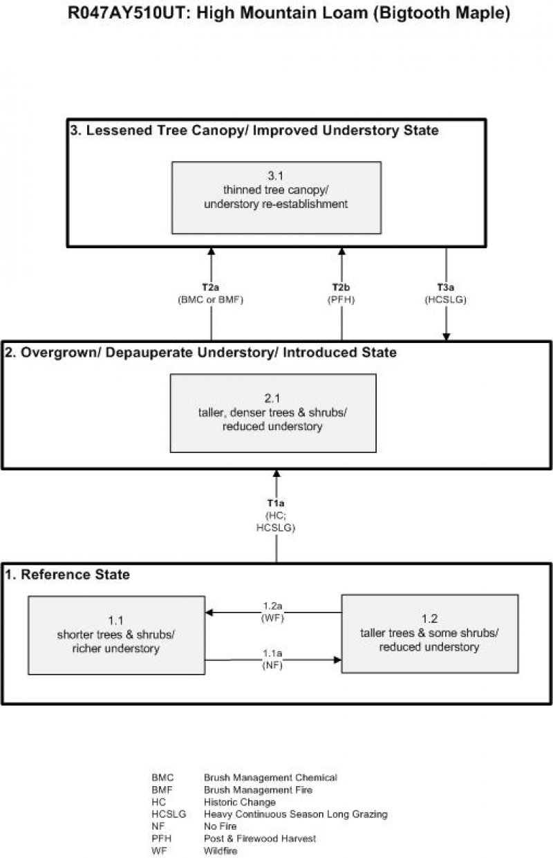
Below is a State and Transition Model diagram that illustrates the “phases” (common plant communities), and “states” (aggregations of those plant communities) that can occur on the site. Differences between phases and states depend primarily upon observations of a range of disturbance histories in areas where this ESD is represented. These situations include grazing gradients to water sources, fence-line contrasts, patches with differing dates of fire, herbicide treatment, tillage, etc. Reference State 1 illustrates the common plant communities that probably existed just prior to European settlement.
The major successional pathways within states, (“community pathways”) are indicated by arrows between phases. “Transitions” are indicated by arrows between states. The drivers of these changes are indicated in codes decipherable by referring to the legend at the bottom of the page and by reading the detailed narratives that follow the diagram. The transition between Reference State 1 and State 2 is considered irreversible because of the naturalization of exotic species of both flora and fauna, possible extinction of native species, and climate change. There may have also been accelerated soil erosion.
The plant communities shown in this State and Transition Model may not represent every possibility, but are probably the most prevalent and recurring plant communities. As more monitoring data are collected, some phases or states may be revised, removed, and new ones may be added. None of these plant communities should necessarily be thought of as “Desired Plant Communities.” According to the USDA NRCS National Range and Pasture Handbook (USDA-NRCS 2003), Desired Plant Communities (DPC’s) will be determined by the decision-makers and will meet minimum quality criteria established by the NRCS. The main purpose for including descriptions of a plant community is to capture the current knowledge at the time of this revision.
The Reference State is a description of this ecological site just prior to Euro-American settlement but long after the arrival of Native Americans. The description of the Reference State was determined by NRCS Soil Survey Type Site Location information and familiarity with rangeland relict areas where they exist. Shorter trees and shrub forms of bigtooth maple (Acer grandidentatum), quaking aspen (Populus tremuloides), and Rocky Mountain juniper (Juniperus scopulorum) would have made up the upper canopy. Other shrubs would have included mallow ninebark (Physocarpus malvaceus) and mountain snowberry (Symphoricarpos oreophilus). Understory shrubs would have been composed primarily of creeping barberry (Mahonia repens), Oregon boxleaf (Paxistima myrsinites), Woods' rose (Rosa woodsii). Grasses would have included blue wildrye (Elymus glaucus), mountain brome (Bromus marginatus), and slender wheatgrass (Elymus trachycaulus). Forbs would have included tall ragwort (Senecio serra), western coneflower (Rudbeckia occidentalis), silvery lupine (Lupinus argenteus), and nettleleaf giant hyssop (Agastache urticifolia) among others. The average fire return interval would have ranged from approximately 50 to 60 years, which would have been the driving factor behind changes in relative abundance and size of trees and associated understory richness. Shorter trees and shrubs with an understory rich in forbs and grasses (1.1) would have been found following recent wildfire events (1.2a). As the length of time elapsed since the fire lengthened (1.1a), trees would have increased both in height and density, while the understory would have lessened (1.2). A more complete list of species by lifeform for the Reference State is available in accompanying tables in the “Plant Community Composition by Weight and Percentage” section of this ESD document.
Community 1.1 shorter trees & shrubs/ richer understory
This plant community would have been characterized by shorter trees and shrubs with a relatively rich understory of smaller shrubs, forbs, and grasses. Bigtooth maple would have been the dominant woody species. The understory would have consisted of a mixture of species including mallow ninebark, mountain snowberry, creeping barberry, Oregon boxleaf, Woods' rose, blue wildrye, mountain brome, tall ragwort, silvery lupine, along with several other herbaceous species.
Figure 5. Annual production by plant type (representative values) or group (midpoint values)
Table 5. Annual production by plant type
Plant type
Low (lb/acre)
Representative value (lb/acre)
High (lb/acre)
Forb
1400
1500
1600
Tree
720
800
850
Grass/Grasslike
280
300
525
Shrub/Vine
140
200
275
Total
2540
2800
3250
Table 6. Ground cover
Tree foliar cover
69-71%
Shrub/vine/liana foliar cover
19-21%
Grass/grasslike foliar cover
9-11%
Forb foliar cover
4-6%
Non-vascular plants
0%
Biological crusts
0%
Litter
0%
Surface fragments >0.25" and <=3"
0%
Surface fragments >3"
0%
Bedrock
0%
Water
0%
Bare ground
0%
Table 7. Canopy structure (% cover)
Height Above Ground (ft)
Tree
Shrub/Vine
Grass/ Grasslike
Forb
<0.5
–
–
–
–
>0.5 <= 1
–
–
–
4-6%
>1 <= 2
–
–
9-11%
–
>2 <= 4.5
–
19-21%
–
–
>4.5 <= 13
–
–
–
–
>13 <= 40
69-71%
–
–
–
>40 <= 80
–
–
–
–
>80 <= 120
–
–
–
–
>120
–
–
–
–
Community 1.2 taller trees & some shrubs/ reduced understory
This phase would have been characterized by increased amounts and height of trees and shrubs, namely bigtooth maple, aspen, and Rocky Mountain juniper, with a corresponding decrease in understory richness.
Pathway 1.1a Community 1.1 to 1.2
As the length of time elapsed since last fire increased (i.e. approaching 50 to 60 years), the trees and shrubs would have grown in both height and density, thus shading out some of the understory.
Pathway 1.2a Community 1.2 to 1.1
Wildfire would temporarily reduce the tree and shrub component allowing the native perennial grasses and forbs to dominate.
State 2 Overgrown/ Depauperate Understory/ Introduced State
State 2 is very similar to State 1 in form and function, with the exception of the presence of non-native plants and animals, possible extinctions of some native species, and a different climate. State 2 is a description of the ecological site shortly following Euro-American settlement and should be considered the current potential. Heavy season-long livestock grazing was prevalent on these sites starting in the 1860s up through the 1950s, which had its most noticeable impact on diminishing the understory.
Community 2.1 taller, denser trees & shrubs/ reduced understory
This plant community is characterized by a taller, denser stand of trees, primarily bigtooth maple and Rocky Mountain juniper, but with a markedly reduced understory. A small component of non-native species may also be present such as cheatgrass (Bromus tectorum), smooth brome (Bromus inermis), or Kentucky bluegrass (Poa pratensis).
State 3 Lessened Tree Canopy/ Improved Understory State
Tree and brush removal by chemical, fire, and/or fuel wood cutting, helped to thin the tree canopy and provide for the re-establishment of the understory shrubs, forbs, and grasses.
Community 3.1 thinned tree canopy/ understory re-establishment
This plant community is characterized by a thinned canopy of bigtooth maple, aspen, and junipers, and re-established understory species such as mallow ninebark, mountain snowberry, creeping barberry, Oregon boxleaf, Woods' rose, blue wildrye, mountain brome, tall ragwort, silvery lupine, along with several other herbaceous species.
Transition T1a State 1 to 2
The simultaneous introduction of exotic species, both plants and animals, possible extinctions of native flora and fauna, climate change, and the advent of intense season-long livestock grazing has caused State 1 to transition to State 2. Reversal of such historic changes (i.e. a return pathway) back to State 1 is not practical.
Transition T2a State 2 to 3
This transition occurred where there was selective harvest of stems for fuel wood and tapping the maple for sugar. Unburned slash with abundant leaf fall makes this vegetation susceptible to wildfire. The root sprouting of maple and other dominants makes it resilient, however. Excessive livestock grazing has been the major agent of positive feedback to accelerated soil erosion and vegetational change. Reduction of livestock numbers and season of use result in a rapid recovery of the perennial dominance. Brush management, whether by chemical means (e.g. 2,4-D, tebuthiron) or prescribed fire, will cause State 2 to transition to State 3.
Cutting the trees for use as fuel wood was prevalent in some areas, which opened up the canopy allowing the understory components to re-establish abundantly if not excessively grazed.
Restoration pathway R3a State 3 to 2
Heavy continuous season long grazing will deplete the understory, decrease the chance of wildfire, and allow tree species to regain in dominance.
Additional community tables
Table 8. Community 1.1 plant community composition
This site has a fair amount of grass, a small amount of forbs, and an exceptionally high amount of shrubs. There is a large variety of species. This site is especially valuable to sheep but can also be used by cattle and horses. This combination of plants provides a balanced nutrition for grazing animals. It should be grazed in spring, summer and fall.
It is fair to poor for openland habitat, good for woodland habitat, very poor for wetland habitat and good for rangeland habitat.
It provides good to fair habitat for chukars, quail, forest grouse, mule deer, elk, squirrels, snowshoe rabbits, songbirds, and coyotes, especially in those areas where oakbrush is interspersed with grassy openings. It is fair to poor habitat for bobcats, cougars, golden eagles, and bear.
Hydrological functions
Soil series in this site are grouped into b and c hydrologic groups. They have moderately low to moderately high runoff potential. When the vegetation is in climax (potential), the hydrologic curves for the soils in b hydrologic group are 45 to 40 and those in c hydrologic group are 50 to 55. When range condition has declined from climax, field investigation is needed in order to determine hydrologic curve numbers.
Recreational uses
This site has good values for aesthetics and natural beauty. It has a large number of forbs and shrubs which have flowers in bloom from early spring throughout the summer and into the fall. It has a combination of grasses, forbs, small shrubs and large shrubs which offer some possibilities for screening and value as camping and picnicking areas. Hunting for elk and mule deer is good to excellent on this site. Fishing is opportune on streams through and adjacent to this site. This site has some value for snowmobiling through a fairly long period of the winter season.
Wood products
No values exist for lumber. Some values exist for fuel for campfires and fireplace wood from bigtooth maple. This species also provides fence posts and fence stays.
Supporting information
Inventory data references
When available, monitoring data (of various types) were employed to validate more subjective inferences made in this diagram. See the complete files in the office of the State Range Conservationist for more details.
Other references
Galatowitsch, S.M. 1990. Using the original land survey notes to reconstruct pre-settlement landscapes in the American West. Great Basin Naturalist: 50(2): 181-191. Keywords: [Western U.S., conservation, history, human impact]
Parson, R. E. 1996. A History of Rich County. Utah State Historical Society, County Commission, Rich County, Utah. Keywords: [Rich County, Utah, Historic land use, European settlements]
USDA-NRCS. 2003. National Range and Pasture Handbook. in USDA, editor, USDA-Natural Resources Conservation Service-Grazing Lands Technology Institute. Keywords: [Western US, Federal guidelines, Range pasture management]
Contributors
Darryl Trickler, G. Brock Benson
Approval
Kendra Moseley, 2/05/2025
Rangeland health reference sheet
Interpreting Indicators of Rangeland Health is a qualitative assessment protocol used to
determine ecosystem condition based on benchmark characteristics described in the Reference Sheet. A suite of 17 (or
more) indicators are typically considered in an assessment. The ecological site(s) representative of an assessment
location must be known prior to applying the protocol and must be verified based on soils and climate. Current plant
community cannot be used to identify the ecological site.
Author(s)/participant(s)
V. Keith Wadman (NRCS Retired).
Contact for lead author
shane.green@ut.usda.gov
Date
11/05/2012
Approved by
Kendra Moseley
Approval date
Composition (Indicators 10 and 12) based on
Annual Production
Indicators
Number and extent of rills:
None to Rare. Some minor rill development may occur on steeper slopes (> 20%) or on areas located below exposed bedrock or other water shedding areas where increased runoff may occur. Where these rills are present, they should be short (1-3 feet), < 1 inch deep and widely spaced (8-12 feet). Minor rill development may be observed on all slopes following major thunderstorm or spring runoff events, but they should heal during the next growing season.
Presence of water flow patterns:
Rare. Some very minor evidence of water flow patterns may be found winding around perennial plant bases. They show little evidence of current erosion. They are expected to be short (2-4 feet), stable, sinuous and normally not connected. There may be very minor evidence of deposition. Evidence of water flow may increase slightly on slopes > 20%.
Number and height of erosional pedestals or terracettes:
Perennial vegetation shows little evidence of erosional pedestalling ( < 1% of individual plants). Plant roots are covered and most litter remains in place around plant crowns. Terracettes should be absent or, if present, stable. A slight increase in both pedestal and terracette development may occur with increasing slope.
Bare ground from Ecological Site Description or other studies (rock, litter, lichen, moss, plant canopy are
not bare ground):
Bare ground ranges from 20% - 30%. Soil surface may be covered by 2 to 25% coarse fragments. Bare ground openings should not be greater than 1 foot in diameter and should normally not be connected.
Number of gullies and erosion associated with gullies:
None to Rare at site level. Scattered landscape level gully channels, however, are a normal component of basin/range environments. Where landscape gullies are present, they should be stable, partially vegetated on their sides and bottoms, with no evidence of head-cutting. Some slight increase in disturbance may be evident following significant weather events or when gullies convey considerable runoff from higher elevation rocky or naturally eroding areas.
Extent of wind scoured, blowouts and/or depositional areas:
None. No evidence of wind generated soil movement is present. Wind caused blowouts and deposition are not present.
Amount of litter movement (describe size and distance expected to travel):
Most litter resides in place with some redistribution caused by water movement. Minor litter removal may occur in flow channels with deposition occurring within 1 to 2 feet at points of obstruction. The majority of litter accumulates at the base of plants. Some grass leaves and small twigs (grass stems) may accumulate in soil depressions adjacent to plants. Woody stems are not likely to move. However, some litter movement is expected (up to 6 feet) with increases in slopes >20% and/or increased runoff resulting from heavy thunderstorms.
Soil surface (top few mm) resistance to erosion (stability values are averages - most sites will show a range
of values):
This site should have a soil stability rating of 5 or 6 under the plant canopies, and a rating of 4 to 5 in the interspaces. The average rating should be a 5. Soil surface textures are typically loams, very fine sandy loams and silt loams.
Soil surface structure and SOM content (include type of structure and A-horizon color and thickness):
(Nordic) Soil surface 0-6 inches. Surface texture is a gravelly loam which may have an organic mat of partially decomposed leaves and twigs 1 inch deep on the surface; color is a very dark grayish brown (10YR 3/2); and structure weak fine granular. Mollic epipedon ranges from 15 to 19 inches. Use the specific information for the soil you are assessing found in the published soil survey to supplement this description.
Effect of community phase composition (relative proportion of different functional groups) and spatial
distribution on infiltration and runoff:
Perennial vegetation produces sufficient cover and spatial arrangement to intercept most raindrops and reduce raindrop splash erosion. Litter on soil surface and cryptogamic crusting, where present, also protects soil from splash erosion and encourages a higher rate of infiltration. Plant spatial distribution should slow runoff, allowing additional time for infiltration. Bare spaces are expected to be small and irregular in shape and are usually not connected. Vegetative structure is usually adequate to capture snow and ensure that snowmelt occurs in a controlled manner, allowing maximum time for infiltration, and reducing runoff and erosion in all but the most extreme storm events. When perennial grasses and shrubs decrease due to natural events including drought, insect damage, etc., which reduce ground cover and increase bare ground, runoff is expected to increase and associated infiltration reduced.
Presence and thickness of compaction layer (usually none; describe soil profile features which may be
mistaken for compaction on this site):
None. Some soils may have natural textural variability within their profiles, these should not be mistaken for a compaction pan.
Functional/Structural Groups (list in order of descending dominance by above-ground annual-production or live foliar
cover using symbols: >>, >, = to indicate much greater than, greater than, and equal to):
A wide variety of other perennial grasses and both perennial and annual forbs can be expected to occur in the plant community.
Additional:
Natural disturbance regimes include fire, drought, and insects. Assumed fire cycle of 40 to 60+ years. Functional/structural groups may appropriately contain non-native species if their ecological function is the same as the native species in the reference. Following a disturbance such as fire, drought, rodents or insects that remove woody vegetation, forbs and perennial grasses (herbaceous species) may dominate the community for a period of time. If a disturbance has not occurred for an extended period of time, woody species may continue to increase. These conditions would reflect different functional community phases within the reference state.
Amount of plant mortality and decadence (include which functional groups are expected to show mortality or
decadence):
All age classes of perennial grasses should be present under average to above average growing conditions with age class expression likely subdued during periods of extended drought. Slight decadence in the principle shrubs could occur near the end of the fire cycle or during periods of extended drought, or insect infestations. In general, a mix of age classes should be expected with some dead and decadent plants present.
Average percent litter cover (%) and depth ( in):
Litter cover will be heavier in maple clumps. Most litter will be a mixture of herbaceous and woody plant tissue, with depths of 2 to 4 inches considered normal. Perennial vegetation should be well distributed on the site.
Expected annual annual-production (this is TOTAL above-ground annual-production, not just forage annual-production):
Annual production in air-dry herbage should be approximately 2700 - 2800 #/acre on an average year but could range from 2400 - 3200 #/acre during periods of prolonged drought or above average precipitation.
Potential invasive (including noxious) species (native and non-native). List species which BOTH characterize
degraded states and have the potential to become a dominant or co-dominant species on the ecological site if
their future establishment and growth is not actively controlled by management interventions. Species that become
dominant for only one to several years (e.g., short-term response to drought or wildfire) are not invasive
plants. Note that unlike other indicators, we are describing what is NOT expected in the reference state for the
ecological site:
All perennial plants should have the ability to reproduce in all years, except in extreme drought years. Green rabbitbrush sprouts vigorously following fire. There are no restrictions on either seed or vegetative reproduction. Some seedling recruitment of major species is present during average and above average growing years.
The Ecosystem Dynamics Interpretive Tool is an information system framework developed by the USDA-ARS Jornada Experimental Range, USDA Natural Resources Conservation Service, and New Mexico State University.
Click on box and path labels to scroll to the respective text.
The server returned a "500 Internal Server Error".
Something is broken. Please let us know what you were doing when this error occurred.
We will fix it as soon as possible. Sorry for any inconvenience caused.