Natural Resources
Conservation Service
Ecological site F144BY302ME
Mucky Swamp
Last updated: 5/12/2025
Accessed: 05/20/2025
General information
Provisional. A provisional ecological site description has undergone quality control and quality assurance review. It contains a working state and transition model and enough information to identify the ecological site.
MLRA notes
Major Land Resource Area (MLRA): 144B–New England and Eastern New York Upland, Northern Part
This major land resource area (MLRA) is in Maine (56 percent), New Hampshire (22 percent), Vermont (14 percent), Massachusetts (6 percent), Connecticut (1 percent), and New York (1 percent). It makes up about 22,728 square miles (58,864 square kilometers). The MLRA consists of a relatively young landscape shaped by the Laurentide Ice Sheet, which covered the region from 35,000 to 10,000 years ago. Rolling hills of dense basal till converge on ridges of shallow bedrock that were scoured by glacial ice. River valleys that were flooded by melting glacial water or seawater house large expanses of glacial outwash and stratified drift in inland areas and, to a lesser extent, glaciomarine and glaciolacustrine sediment deposits in coastal areas. Organic bogs, ablation till, and alluvial flood plains make up the remaining portions of the MLRA.
The soils in this region are dominantly Entisols, Spodosols, and Inceptisols. They commonly have a fragipan. The dominant suborders are Ochrepts, Orthods, Aquepts, Fluvents, and Saprists. The soils in the region dominantly have a frigid soil temperature regime with some cryic areas at higher elevation, a udic soil moisture regime, and mixed mineralogy. Most of the land is forested, and 98 percent is privately owned. Significant amounts of forest products are produced including lumber, pulpwood, Christmas trees, and maple syrup. Principal agricultural crops include forage and grains for dairy cattle, potatoes, apples, and blueberries. Wildlife habitat and recreation are important land uses. Stoniness, steep slopes, and poor drainage limit the use of many of the soils.
Classification relationships
NRCS:
Land Resource Region: R—Northeastern Forage and Forest Region
MLRA: 144B—New England and Eastern New York Upland, Northern PartMLRA resources
Major Land Resource Area (MLRA): 144B–New England and Eastern New York Upland, Northern Part
Ecological site concept
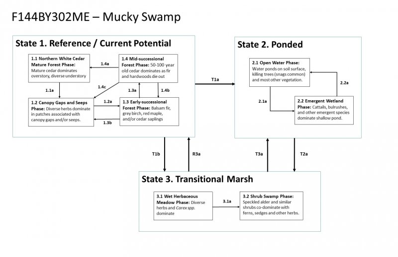
This site occurs in relatively flat areas (0-2% slopes) near the bottom of watersheds where water saturates deep organic muck deposits for most of the growing season. These organic soils are very poorly-drained and often underlain by mineral deposits at depths greater than 16 inches. The water table is within a few inches of the surface. This site often has pit and mound topography, with ponding typical in the pits, and slightly drier soil conditions on the mounds where most trees are rooted.
Northern white cedar is abundant, with balsam fir, black spruce, larch, and brown ash as common associates. In southern areas Atlantic white cedar may dominate instead of northern white cedar. Further study is required to distinguish between northern and southern variants. Diverse herbs, shrubs, and bryophytes dominate the understory. Treethrow and altered hydrology are common disturbances on this site. Small openings created by treethrow, which is very common on these unstable soils, are typically colonized by species already present in the community and may persist as canopy openings dominated by herbaceous species for a long time.
Persistent ponding caused by beavers, man-made structures (such as roads, dams, etc.), or increased runoff in the watershed above can cause water levels to rise and kill cedar trees, resulting in an open ponded or marsh condition. If hydrology is restored to reference conditions, the site is likely to transition through a marsh and/or early seral forest phase before eventually returning to cedar dominance.
Logging is limited on this site and requires winter harvest methods when the ground is frozen. Cedar removal may result in an early seral phase dominated by balsam fir, grey birch, red maple, and other colonizers before eventually reverting to cedar dominance. This may take a very long time to occur.
Associated sites
| F144BY301ME |
Loamy Till Swamp The Mucky Peat Swamp often occurs downslope of the Loamy Till Swamp as all soils become very poorly drained and soil surface organic layer increases to greater than 16 inches. |
|---|---|
| F144BY304ME |
Wet Clay Flat The Loamy Wet Flat site occurs on poorly-drained flats, which are drier than the Mucky Swamp. Wet Flats support more spruce and less cedar, as well as less understory productivity, particularly less moss. |
Similar sites
| F144BY301ME |
Loamy Till Swamp Both the Mucky Peat Swamp and the Loamy Till Swamp are dominated by northern white cedar, but the Mucky Peat Swamp is wetter, has a thicker organic soil surface layer, and typically has a more open canopy, allowing more light to reach the forest floor. As a result, the understory is often more productive in the Mucky Peat Swamp. |
|---|
Table 1. Dominant plant species
| Tree |
(1) Thuja occidentalis |
|---|---|
| Shrub |
Not specified |
| Herbaceous |
Not specified |
Click on box and path labels to scroll to the respective text.