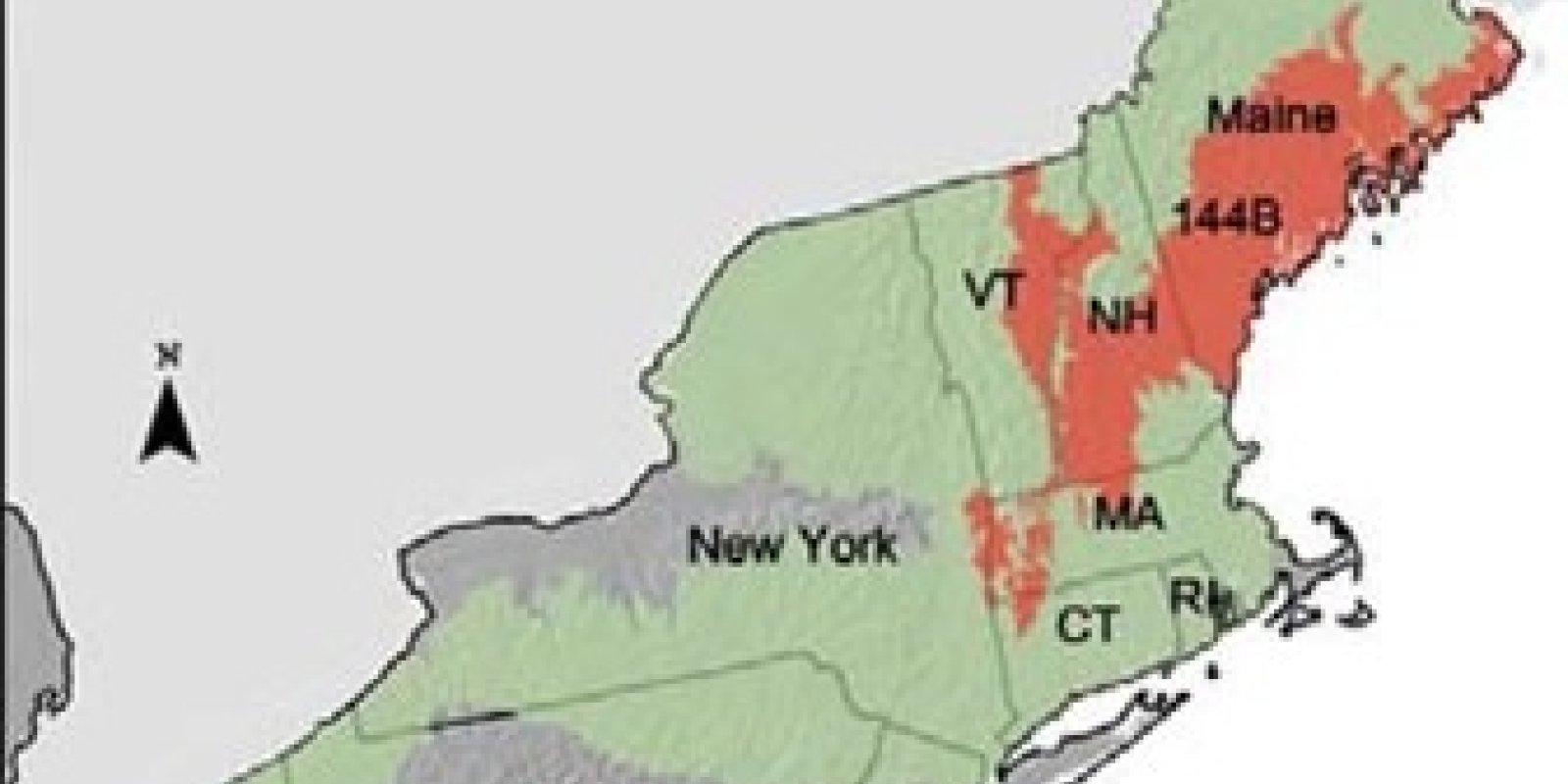
Major Land Resource Area 144B
New England and Eastern New York Upland, Northern Part
Accessed: 05/19/2025
Description
The area in MLRA 144B spans across six Northeastern states: Maine (56 percent), New Hampshire (22 percent), Vermont (14 percent), Massachusetts (5 percent), New York (2 percent), and Connecticut (1 percent). It makes up about 20,500 square miles (53,125 square kilometers). Most of this area is in Maine and New Hampshire, but a small, separate part is on the Vermont- Massachusetts border with New York. The majority of Maine’s population is in this MLRA. This is the easternmost MLRA in the country. It includes the cities of Bangor, Augusta, and Portland, Maine; the towns of Littleton, Plymouth, and Laconia, New Hampshire; and the towns of Montpelier, Barre, and St. Johnsbury, Vermont. The separate part of the MLRA on the eastern border of New York has no cities. Interstates 89, 90, 91, 93, and 95 cross different parts of this MLRA. Some of the White Mountain National Forest is in the part of the MLRA in New Hampshire, and the Acadia National Park is in the part in Maine. The Rachel Carson National Wildlife Refuge is in the part in southeast Maine. A large number of State forests and State parks are throughout this MLRA. Physiography This area is the New England Province of the Appalachian Highlands. The separate western part of the area is in the Taconic Section of the province. The rest of the area is mostly in the New England Upland Section. The part in southeastern Maine is in the Seaboard Lowland Section. This MLRA includes the entire coastal zone of Maine and extends inland along the major river valleys. Most of the area is characterized by rolling to hilly uplands. The area has some isolated mountain peaks. In the part of the area in southeastern Maine, gently sloping to level valleys terminate in coastal lowlands. Elevation ranges from sea level to 1,000 feet (0 to 305 meters) in much of the area. It is 2,000 feet (610 meters) on some hills and 2,950 feet (900 meters) on a few isolated peaks. Local relief is mostly low or moderate. It generally is highest in the northern part of the area and decreases as sea level is approached. An exception is the Taconic Mountains along the New York-Massachusetts border, where relief is substantial. Relief is mostly about 5 to 65 feet (2 to 20 meters) in the valleys and about 80 to 330 feet (25 to 100 meters) in the uplands. The extent of the major Hydrologic Unit Areas (identified by four-digit numbers) that make up this MLRA is as follows: Connecticut (0108), 20 percent; Maine Coastal (0105), 15 percent; Saco (0106), 15 percent; Kennebec (0103), 13 percent; Merrimack (0107), 11 percent; Penobscot (0102), 9 percent; Androscoggin (0104), 6 percent; Richelieu (0201), 4 percent; Upper Hudson (0202), 3 percent; St. Francois (0111), 2 percent; Connecticut Coastal (0110), 2 percent. In this area, the Piscataqua and Saco Rivers begin in New Hampshire and flow into Maine. The Penobscot and Saco Rivers are in the part of this area in Maine. Another major river in the area is the Merrimack River in New Hampshire. The part of the area in Vermont encompasses the upper end of the Connecticut River drainage and the headwaters of the Lamoille and Winooski Rivers. The small, separate part of the MLRA on the eastern border of New York has short reaches of the Batten Kill River in Vermont, the Kinderhook River in New York, and the headwaters of the Housatonic River in Massachusetts. Geology Most of this MLRA is characterized by till-mantled, rolling to hilly uplands. The northern and eastern parts of the area are underlain mostly by granite, gneiss, and schist bedrock. Limestone, dolomite, and marble beds interspersed with basalt flows occur in the southern and western parts. Stratified drift deposits of unconsolidated sand and gravel, primarily glacial outwash, fill most of the narrow river valleys. Some marine sediments occur at the lower end of the valleys that terminate in the coastal lowlands in southeastern Maine. Some glacial lake sediments occur on valley floors behind glacial moraines. The areas of marine and glacial lake sediments are not extensive but are important agricultural areas. Climate The average annual precipitation in most of this area is 33 to 45 inches (840 to 1,145 millimeters). It is 45 to 69 inches (1,145 to 1,755 millimeters) in a few scattered, higher elevation areas and along the coast. The precipitation generally is evenly distributed throughout the year. Near the coast, however, it is slightly lower in summer. In inland areas, it is slightly higher in spring and fall. Rainfall occurs as high-intensity, convective thunderstorms during the summer. During the winter, most of the precipitation occurs as moderate-intensity storms (northeasters) that produce large amounts of rain or snow. Heavy snowfalls commonly occur late in winter. The average annual temperature is 39 to 48 degrees F (4 to 9 degrees C). The freeze-free period averages 160 days and ranges from 120 to 195 days. Temperatures and the length of the freeze-free period increase from north to south and closer to the coast. Water Following are the estimated withdrawals of freshwater by use in this MLRA: Public supply—surface water, 13.4% ground water, 4.5% Livestock—surface water, 0.2% ground water, 0.3% Irrigation—surface water, 0.2% ground water, 0.0% Other—surface water, 73.2% ground water, 8.3% The total withdrawals average 885 million gallons per day (3,350 million liters per day). About 13 percent is from ground water sources, and 87 percent is from surface water sources. Abundant precipitation, many perennial streams, and many natural lakes and ponds are important sources of surface water. Many large and small reservoirs provide municipal and industrial water. The surface water in the area is of good quality and is suitable for almost all uses with no or minimal treatment. Acid rain and municipal and industrial waste discharges are the primary sources of contamination of the surface water. Ground water is scarce on the till-mantled uplands but is abundant in the deep outwash deposits in the valleys. Most public supplies and industries that use ground water obtain the water from the stratified drift aquifer in the river valleys. The water from this aquifer is soft to very hard, is acidic, and has very low levels of total dissolved solids, 75 to 125 parts per million (milligrams per liter). The aquifer is only about 100 feet (30 meters) thick, and the water table is typically at a depth of 30 feet (10 meters). As a result, water in the aquifer is very susceptible to contamination from surface activities. Domestic and some public supply and light industry water is obtained from wells drilled in the granite, gneiss, and schist bedrock under the uplands in Vermont, New Hampshire, and Maine. This water has slightly more total dissolved solids and generally is harder than the water in the valley fill aquifers. Also, there are more instances of iron concentrations exceeding 300 parts per billion (micrograms per liter) in water from the crystalline bedrock aquifer. This is the national and State secondary standard for iron in drinking water. High levels of radon-222 occur in wells drilled into granite that has high amounts of muscovite and biotite. Industrial and domestic wells pump water from a carbonate aquifer on the western edge of Massachusetts, in the northeast corner of Connecticut, and along the eastern border of New York. This aquifer consists of beds of limestone, dolomite, and marble interspersed with beds of schist and quartzite. The water from this aquifer is very hard and has more than 500 parts per million (milligrams per liter) total dissolved solids. This level exceeds the national secondary drinking water standard. Soils The dominant soil orders in this MLRA are Inceptisols and Spodosols. The soils in the area dominantly have a frigid soil temperature regime, an aquic or udic soil moisture regime, and isotic, illitic, or mixed mineralogy. They are shallow to very deep, generally excessively drained to poorly drained, and loamy or sandy. Eutrudepts (Buxton series) and Epiaquepts (Scantic series) formed in glaciomarine or glaciolacustrine deposits on coastal lowlands and in valleys. Dystrudepts formed in till on till plains and moraines (Lanesboro, Shelburne, and Colrain series) and on hills and ridges (Taconic series). Haplorthods formed in glaciofluvial deposits on outwash plains and eskers (Adams and Colton series); in till on till plains, ridges, and moraines (Bangor, Berkshire, Dixmont, Hermon, Lyman, Monadnock, and Tunbridge series); and in dense till on drumlins and uplands (Marlow and Peru series). Biological Resources This area supports northern hardwoods. Beech, white birch, yellow birch, sugar maple, and hemlock are dominant on the better drained soils. Spruce and balsam fir are dominant on the wetter soils and on mountaintops. The northern aspects of mountain slopes favor spruce and fir, and the southern aspects support northern hardwoods. White pine is common on abandoned farmland, in river valleys, and on outwash plains. Spruce fir, mountain cranberry, and similar acid-tolerant plants grow on alpine or subalpine mountaintops. Some of the major wildlife species in this area are white- tailed deer, beaver, snowshoe hare, muskrat, mink, and ruffed grouse. The species of fish in the area include trout, salmon, alewife, striped bass, smelt, and eel. Land Use Following are the various kinds of land use in this MLRA: Cropland—private, 4% Grassland—private, 2% Forest—private, 76%; Federal, 1% Urban development—private, 7% Water—private, 6% Other—private, 4% Almost four-fifths of this area is in hardwood and conifer forests, most of which are in small holdings. Some areas are in State forests or in other large holdings. Sawlogs and pulp for paper mills are the principal products, but maple syrup and Christmas trees are produced on some sites. The forests are widely used for hunting and other kinds of recreation. A significant acreage of the forestland is used for residential and leisure home developments. Forage crops for dairy cattle are grown on most of the cropland in the area. Truck crops, small fruits, and apples are grown on some farms, mainly near the larger towns and cities. Native lowbush blueberries are produced in an area in the extreme eastern part of this MLRA. This is the largest blueberry production area in the world. Many farmsteads are used as rural residences, and the residents earn their living from nonfarm occupations. Urban development is increasing in this populous MLRA. The major soil resource concerns are sheet, rill, and gully erosion on cropland and on logging roads and forest landings and sedimentation in urban areas during periods of construction. Other resource concerns on cropland include nutrient management, maintenance of the content of organic matter in the soils, maintenance of soil quality, and the loss of important farmland to development. Conservation practices on cropland generally include crop residue management (no-till), diversions, grassed waterways, cover crops, and filter strips. They also include management of the storage and utilization of all sources of nutrients on farms. Conservation practices on forestland generally include riparian buffer zones, sediment control on roads and in ditches, and proper stream crossings, which prevent sedimentation and help to maintain water quality.
Key publications
Next steps
-
1
Select an ecological site
Select an ecological site using the list, keys, photos, briefcase, or quick search option located on this page. -
2
Explore the ecological site description
Next, learn more about the selected ecological site and its characteristic dynamics by browsing the ecological site description and exploring alternative state and transition model formats.