
Arctic Ice-Wedge Polygon Complex
Scenario model
Current ecosystem state
Select a state
Management practices/drivers
Select a transition or restoration pathway
-
Transition T1
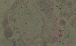
thermal erosion of ice wedges
More details -
No transition or restoration pathway between the selected states has been described
Target ecosystem state
Select a state
State 1
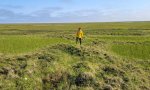
Low-center Polygon State
Description
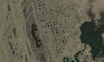
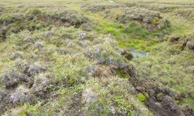
This state covers all landforms with low-center polygons. Three plant communities were identified in this state. Plant community 1.1 is associated with the low-center of the polygon, plant community 1.2 the adjacent rim, and plant community 1.3 the ice-wedge trough. In the National Petroleum reserve, the low-center of these polygon commonly range in diameter from 30 to 100 feet. The adjacent rims are commonly 3 or more feet wide and 2 or more feet tall.
Submodel
State 2
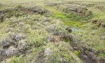
Thermokarst State


Description
This state relates to high-centered ice wedge polygon and these are polygon whose center is raised relative to its boundary. There are two associated plant communities related to polygon microtopography in this state: domed center of the polygon (community 1.1) and ice wedge trough (community 1.2). The troughs are often perennially ponded with shallow water and supports a wet graminoid herbaceous community dominated by various sedges. The polygon dome supports ericaceous dwarf scrub communities dominated by lingonberry, marsh Labrador tea, various sedges, and various moss.
Submodel
Mechanism
Thermal erosion of ice wedges and/or infilling of low-center results in the transformation of low-center polygon to high-center polygon. This is a natural process that can take thousands of years. Climate change and anthropogenic disturbances to associated soils can much more rapidly cause thermal erosion of ice wedges and cause this transformation.
Model keys
Briefcase
Add ecological sites and Major Land Resource Areas to your briefcase by clicking on the briefcase (![]() ) icon wherever it occurs. Drag and drop items to reorder. Cookies are used to store briefcase items between browsing sessions. Because of this, the number of items that can be added to your briefcase is limited, and briefcase items added on one device and browser cannot be accessed from another device or browser. Users who do not wish to place cookies on their devices should not use the briefcase tool. Briefcase cookies serve no other purpose than described here and are deleted whenever browsing history is cleared.
) icon wherever it occurs. Drag and drop items to reorder. Cookies are used to store briefcase items between browsing sessions. Because of this, the number of items that can be added to your briefcase is limited, and briefcase items added on one device and browser cannot be accessed from another device or browser. Users who do not wish to place cookies on their devices should not use the briefcase tool. Briefcase cookies serve no other purpose than described here and are deleted whenever browsing history is cleared.
Ecological sites
Major Land Resource Areas
The Ecosystem Dynamics Interpretive Tool is an information system framework developed by the USDA-ARS Jornada Experimental Range, USDA Natural Resources Conservation Service, and New Mexico State University.