Natural Resources
Conservation Service
Ecological site F131AY313MS
Yazoo – Pleistocene Valley Train Braid Bar Woodland
Last updated: 6/10/2025
Accessed: 10/19/2025
General information
Provisional. A provisional ecological site description has undergone quality control and quality assurance review. It contains a working state and transition model and enough information to identify the ecological site.
MLRA notes
Major Land Resource Area (MLRA): 131A–Southern Mississippi River Alluvium
The Southern Mississippi River Alluvium (MLRA 131A) is the largest of 4 MLRAs within Land Resource Region O, the Mississippi Delta Cotton and Feed Grains Region. It occurs in portions of 7 states including Louisiana (32 percent), Arkansas (26 percent), Mississippi (26 percent), Missouri (12 percent), Tennessee (3 percent), Kentucky (1 percent), and Illinois (less than 1 percent). The MLRA is comprised of 29,555 square miles and extends roughly 650 miles from an area near Cape Girardeau, Missouri in the north to the MLRA’s transition to the Gulf Coast Marsh (MLRA 151) in the south. Average elevations range from 330 feet in the north to sea level in the southern part of the area. For much of the north-south distance, the MLRA is bounded to the east by an abrupt rise in elevation of loess-capped bluffs and hills, the Southern Mississippi Valley Loess (MLRA 134). West of the Mississippi River, the boundary is less distinct except to the northwest where the MLRA abuts the Ozark Plateaus and Ouachita province (MLRAs 116A, 117, and 118A). South of the Ozark and Ouachita escarpment, the MLRA adjoins the Southern Mississippi River Terraces (MLRA 131D), which includes the fabled Grand Prairie and merges with the valleys of the Arkansas and Ouachita rivers (MLRA 131B) and the Red River (MLRA 131C). Occurring within or bordering the Southern Mississippi River Alluvium are three separate loess-capped, upland remnants: Crowley’s Ridge, Macon Ridge, and Lafayette Loess Plain, which are western units of MLRA 134 (USDA-NRCS, 2006a).
MLRA 131A is characterized by landscapes that were created and influenced by the current and earlier paths of the Mississippi River and its tributaries. Waters transporting the materials that formed the area originate from as far west as the east slope of the Continental Divide to the western edge of the Appalachian Divide in the east. This comprises a drainage basin of roughly 1,245,000 square miles and includes all or parts of thirty-one U.S. states and two Canadian provinces (Elliott, 1932). The drainage basin of the Mississippi River roughly resembles a funnel, which has its spout at the Gulf of America. Waters from as far east as New York and as far west as Montana contribute to flows in the lower extent of the river (USACE, 2017). The soils of these alluvial landscapes are very deep, dominantly poorly and somewhat poorly drained, and have textures that are mostly loamy or clayey. Principal soil orders are Alfisols, Vertisols, Inceptisols, and Entisols (USDA-NRCS, 2006a).
The fluvial processes that shaped the area were highly dynamic, diverse, and complex. During the Pleistocene epoch, multiple continental glacial-interglacial cycles resulted in extreme fluctuations in river discharge and sediment loads. A braided river regime characterized the fluvial dynamics of the Mississippi River through much of the last glacial cycle (Autin et al., 1991; Rittenhour et al., 2007). Rapid aggradation of glacial outwash led to the development of prominent valley train features over a large portion of the area (Autin et al., 1991; Saucier, 1994; Aslan and Autin, 1999; Blum et al., 2000; Rittenour et al., 2007). A changing climate, meltwater withdrawal, and sea-level change induced a transition from a braided river regime to a predominantly single-channeled, laterally migrating river system during the Holocene epoch (Rittenhour et al., 2007; Shen et al., 2012) – characteristics that continue today. Fluvial dynamics of the migrating river resulted in the development of broad meander belts, backswamp environments, and extensive deltaic complexes (Saucier, 1994; Klimas et al., 2011).
Tremendous expanses of bottomland hardwood forests once covered much of the area. Today, the land base is largely in agriculture production, and soybeans, cotton, corn, and rice are the principal crops with sugarcane rising in importance in the southernmost portion of the MLRA (USDA-NRCS, 2022).
Due to its size and biophysical variability, the technical team advised subdividing the MLRA into six subregions: Western Lowlands, St. Francis Basin, Yazoo Basin, Tensas Basin, Delta Plain, and Batture.
LRU notes
There are no agency-approved and established Land Resource Units (LRUs) for MLRA 131A. However, the characteristics of each of the six subregions in this MLRA warrant noting and are presented here for each associated ecological site. This provisional ecological site occurs in the Yazoo Basin.
The Yazoo Basin is in northwest Mississippi and is the largest tributary basin within MLRA 131A. The MLRA boundary of the basin extends some 200 miles (north to south) from Memphis, Tennessee to Vicksburg, Mississippi; is about 60 miles wide (east to west) at its widest point; encompasses roughly 7,600 square miles; and is bounded by the Loess Hills to the east and the current Mississippi River channel to the west (Saucier, 1994; Klimas et al., 2011). Elevations range from 210 feet in the northern portions of the basin to about 85 feet in the south near Vicksburg (Kirchner et al., 1992).
The basin’s geomorphic features are dominated by abandoned Mississippi River meander belts and backswamp environments. The higher elevations of natural levees and point bar deposits (meander scrolls) form an alluvial ridge, which directs local drainage and floodwaters to the intervening flood basins or backswamps. Additional meander belt landforms that are quite common include abandoned channels (oxbow lakes) and courses (Saucier, 1994; Klimas et al., 2011). A minor feature of the Yazoo Basin is the Pleistocene-age valley train terraces, which comprise less than 5 percent of the total area (Saucier, 1994).
The movement of water through the Yazoo Basin is heavily influenced and controlled by the complex sequence of abandoned Mississippi River meander belts and distributary channels. Most surface water originates as precipitation (Berkowitz et al., 2020) or runoff from the uplands to the east, which are conveyed by the Coldwater, Yocona, Tallahatchie, and Yalobusha rivers in addition to several smaller streams. These systems, along with streams draining the interior portions of the basin (e.g., Big Sunflower River, Bogue Phalia, and the distributary Deer Creek), all flow to the only significant outlet for the basin, the Yazoo River, which enters the Mississippi River near Vicksburg (Saucier, 1994; Klimas et al., 2011).
Historically, large floods on the Mississippi River and in the Yazoo tributary system inundated most, if not all, of the Yazoo Basin (Moore, 1972). These periodic floods and the ponding aftereffects oftentimes lasted for very long durations (Berkowitz et al., 2020), delivering nutrient-rich sediments that are critical to the production and maintenance of the dominant natural vegetation, bottomland hardwood forests (Taylor et al., 1990; MMNS, 2015). Since settlement, the biophysical environment of the area has been vastly altered. Perhaps the most notable change entails extensive modification of the basin’s natural hydrology, which includes hundreds of miles of constructed levees along the mainstem of the Mississippi River and basin tributaries; channel modifications on many streams; water control structures; land leveled areas; and an extensive network of surface drainage systems (Kirchner et al., 1992). Even with these measures, widespread backwater flooding occurs in the southern portion of the area (Yazoo Backwater Area) when high stages are reached on the Mississippi River. The extensive modifications to the basin’s hydrology coupled with increased access (Hudson, 1979) set the stage for broadscale conversion of former forestland to a variety of land uses with agriculture production being dominant. Today, bottomland hardwood forests cover roughly 10 percent of the original forest area (Smith and Klimas, 2002).
The geographic distribution of all ecological sites within the Yazoo Basin is bounded to the west by an extensive, mainline levee system. Throughout its length, the constructed levee generally occurs within the current Mississippi River meander belt and is situated to the east of the active river channel. All lands between the river channel and the constructed levee are referred to as the Batture, and that subregion encapsulates its own complement of ecological sites due to significantly different hydrologic regimes (Smith and Klimas, 2002).
Classification relationships
All or portions of the geographic range of this site fall within several ecological and land classifications including:
- NRCS Major Land Resource Area (MLRA) 131A – Southern Mississippi River Alluvium (USDA-NRCS, 2006a)
- National Hierarchical Framework of Ecological Units: 234 Lower Mississippi Riverine Forest Province; 234D White and Black River Alluvial Plains Section; 234Da North Mississippi River Alluvial Plain Subsection (Cleland et al., 2007)
- Environmental Protection Agency Level III Ecoregion: 8.5.2 Mississippi Alluvial Plain, 73; Level IV Ecoregion: 73b - Northern Pleistocene Valley Trains (Chapman et al., 2004; Wiken et al., 2011)
- Mississippi River High Floodplain (Bottomland), CES203.196 (NatureServe, 2020)
Ecological site concept
This ecological site has a narrow distribution in the Yazoo Basin where it is restricted to the higher elevations or positions on valley train geomorphic features. The characteristic landform of this site consists of remnant depositional ridges and braid bars that were created during catastrophic flood releases (or pulses) of glacial outwash during the Late Pleistocene epoch. Today, these depositional features consist of a series of disjunct mounds and low, elongated ridges that are positioned beside and within the highly braided and dendritic network of remnant, glacial outwash channels. The soils of this site are described as deep, well drained to moderately well drained that formed in silty alluvium – stream and river sediments that veneered the underlying coarse outwash materials. Recent observations and a revisit of these soils strongly suggest that drainage and permeability can be more rapid than initially described. Evidence for this is expressed by plant stress and possibly poorer crop yields in some locations. The historic plant community of this site is unknown. These soils occur as small isolates within a much larger mosaic of productive soils. Hence, most occurrences of this site have been converted to agriculture production or was once under other forms of intensive land use such as grazing and human habitation. Archaeological discoveries over the past century have revealed human occupation or presence on this site for millennia. Depending on the presence and intensity of human activities, several conditions and habitat types likely existed, including local cultural and habitation sites, herbaceous openings, savannas, open woodlands, and forests. Fire was likely a historic management tool on this site. Based on forest surveys and research, the cover type most characteristic of this site may have been a diverse mixture of oaks and other bottomland hardwoods.
Associated sites
| F131AY303MS |
Yazoo - Low Clayey Backswamp Ridge Forest The Pleistocene valley train geomorphic features in the Yazoo Basin have been heavily veneered with Holocene alluvial deposits including the clayey soils of this site. F131AY303MS adjoins the Pleistocene braid bars (F131AY313MS) in a few areas and should be recognized as a minor associate. |
|---|---|
| F131AY307MS |
Yazoo - Old Moderately Wet Natural Levee and Meander Scroll Ridge Forest The Pleistocene valley train geomorphic features in the Yazoo Basin have been heavily veneered with Holocene alluvial deposits including the loamy soils of this site. F131AY307MS adjoins the Pleistocene braid bars (F131AY313MS) in a few areas and should be recognized as a minor associate. |
| F131AY308MS |
Yazoo - Old Wet Natural Levee and Meander Scroll Forest The Pleistocene valley train geomorphic features in the Yazoo Basin have been heavily veneered with Holocene alluvial deposits including the poorly drained, clayey and silty soils of this site. F131AY308MS broadly adjoins the Pleistocene braid bars (F131AY313MS) and should be regarded as a major associate. |
| F131AY301MS |
Yazoo - Frequently Flooded and Ponded Oxbow and Swale Forest This site occupies depressions within remnant glacial outwash channels on Pleistocene valley trains, which adjoins the relic braid bars of site F131AY313MS. |
Similar sites
| F131AY109AR |
Western Lowlands - Old Loamy Natural Levee and Braided Interfluve Forest This site developed under similar conditions and occurs on similar geomorphic features as site F131AY313MS. The principal difference is that F131AY109AR occurs in the Western Lowlands of Arkansas and Missouri. |
|---|---|
| F131AY204AR |
St. Francis - Braid Bar Woodland This site developed under similar conditions and occurs on similar geomorphic features as site F131AY313MS. The principal difference is that F131AY204AR occurs in the St. Francis Basin of Arkansas and Missouri. |
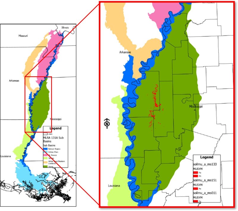
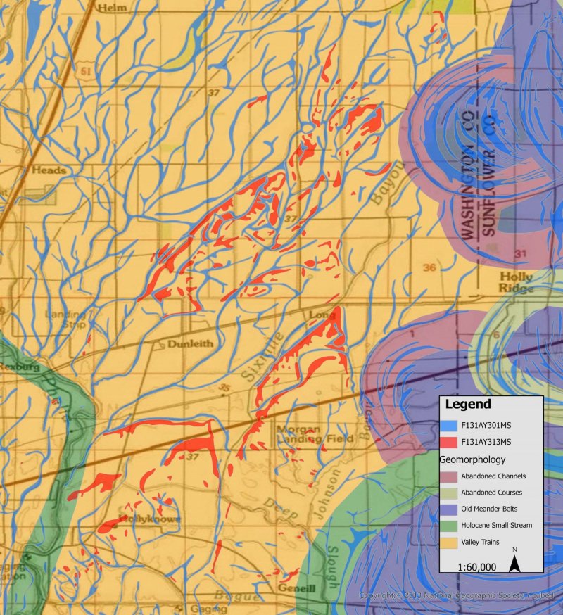
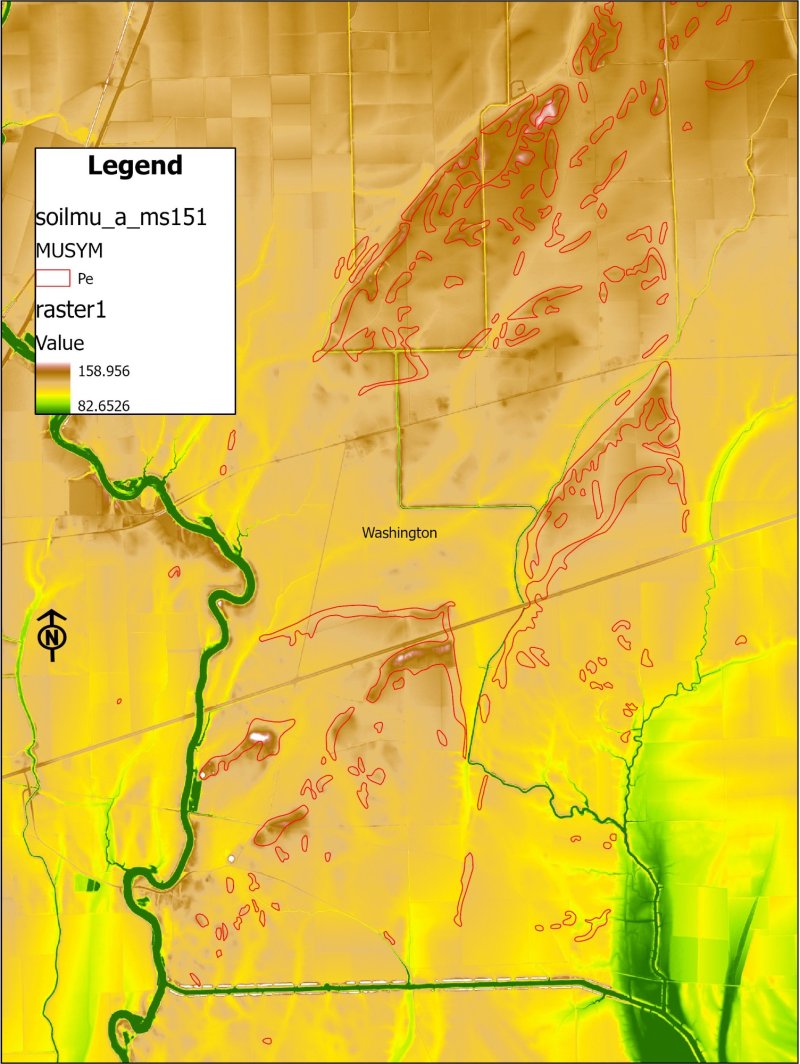
Figure 1. Distribution of Site F131AY313MS.
Table 1. Dominant plant species
| Tree |
Not specified |
|---|---|
| Shrub |
Not specified |
| Herbaceous |
Not specified |
Click on box and path labels to scroll to the respective text.
Ecosystem states
States 2, 5 and 6 (additional transitions)
| T1A | - | Vegetation/stump removal (mechanical/chemical); preparation for cultivation |
|---|---|---|
| T1B | - | Vegetation/stump removal (mechanical/chemical); seedbed preparation; establishment of desired forage; manage for grazing |
| T2A | - | Precision land leveling |
| T2B | - | Vegetation/stump removal (mechanical/chemical); seedbed preparation; establishment of desired forage; manage for grazing |
| T2C | - | Natural succession (Community 5.1) or prep area (plow pan breakup, fertilizing, etc.) and plant species appropriate for site (Afforestation - Community 5.2) |
| T2D | - | Establish select native species suitable for site; prepare for planting (herbicide and/or mechanical) |
| T4A | - | Vegetation/stump removal (mechanical/chemical); preparation for cultivation |
| T4B | - | Natural succession (Community 5.1) or prep area (plow pan breakup, fertilizing, etc.) and plant species appropriate for site (Afforestation - Community 5.2) |
| T4C | - | Establish select native species suitable for site; prepare for planting (herbicide and/or mechanical) |
| T5A | - | Vegetation/stump removal (mechanical/chemical); preparation for cultivation |
| T5B | - | Vegetation/stump removal (mechanical/chemical); seedbed preparation; establishment of desired forage; manage for grazing |
| T6A | - | Vegetation/stump removal (mechanical/chemical); preparation for cultivation |
| T6B | - | Vegetation/stump removal (mechanical/chemical); seedbed preparation; establishment of desired forage; manage for grazing |
| T6C | - | Natural succession (Community 5.1) or prep area (plow pan breakup, fertilizing, etc.) and plant species appropriate for site (Afforestation - Community 5.2) |
State 1 submodel, plant communities
State 2 submodel, plant communities
| 2.1A | - | Soil disturbance (tillage); reduction of soil health. |
|---|---|---|
| 2.1B | - | Conventional tillage, seeding, and fertility management for crops. |
| 2.2A | - | No-till, cover crops, reduced till-soil health improvements. |
| 2.2B | - | Conventional tillage, seeding, and fertility management for crops. |
| 2.3A | - | Reduced till, no-till, and cover crops with soil health improvements as a goal. |
State 3 submodel, plant communities
State 4 submodel, plant communities
| 4.1A | - | Seeding and/or management for desired species composition. |
|---|---|---|
| 4.1B | - | Species management without overseeding. |
| 4.2A | - | Seeding, fertilizing, management/removal of undesirable species. |
| 4.2B | - | Species management without overseeding |
| 4.3A | - | Seeding, fertilizing, management/removal of undesirable species. |
| 4.3B | - | Seeding and/or management for desired species composition. |
| 4.3C | - | Lack of disturbance; no (infrequent) mowing, herbivory, or brush management; natural succession of woody species. |
| 4.4A | - | Brush management/removal of unwanted species. |
State 5 submodel, plant communities
| 5.1A | - | Remove undesirable competitors; final soil preparation; establish site-appropriate species (favored in management). |
|---|