Natural Resources
Conservation Service
Ecological site R028AY258UT
Semidesert Very Shallow Loam (Littleleaf Mountain Mahogany)
Last updated: 5/02/2025
Accessed: 10/20/2025
General information
Provisional. A provisional ecological site description has undergone quality control and quality assurance review. It contains a working state and transition model and enough information to identify the ecological site.
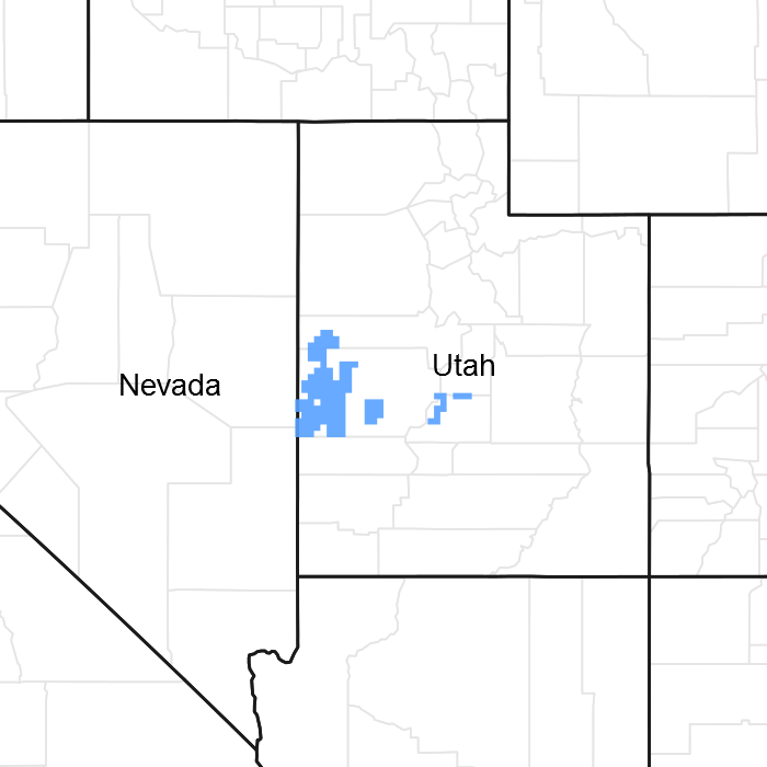
Figure 1. Mapped extent
Areas shown in blue indicate the maximum mapped extent of this ecological site. Other ecological sites likely occur within the highlighted areas. It is also possible for this ecological site to occur outside of highlighted areas if detailed soil survey has not been completed or recently updated.
MLRA notes
Major Land Resource Area (MLRA): 028A–Ancient Lake Bonneville
MLRA 28A occurs in Utah (82 percent), Nevada (16 percent), and Idaho (2 percent). It encompasses approximately 36,775 square miles (95,246 square kilometers). A large area west and southwest of Great Salt Lake is a salty playa. This area is the farthest eastern extent of the Great Basin Section of the Basin and Range Province of the Intermontane Plateaus. It is an area of nearly level basins between widely separated mountain ranges trending north to south. The basins are bordered by long, gently sloping alluvial fans. The mountains are uplifted fault blocks with steep side slopes. Most of the valleys are closed basins containing sinks or playa lakes. Elevation ranges from 3,950 to 6,560 feet (1,204 to 2000 meters) in the basins and from 6,560 to 11,150 feet (1996 to 3398 meters) in the mountains. Much of the MLRA has alluvial valley fill and playa lakebed deposits at the surface from pluvial Lake Bonneville, which dominated this MLRA 13,000 years ago. A level line of remnant lake terraces on some mountain slopes indicates the former extent of this glacial lake. The Great Salt Lake is what remains of the pluvial lake.
Mountains in the interior of this MLRA consist of tilted blocks of marine sediments from Cambrian to Mississippian age with scattered outcrops of Tertiary continental sediments and volcanic rocks. The average annual precipitation is 5 to 12 inches (13 to 30 cm) in the valleys and ranges up to 49 inches (124 cm) in the mountains. Most of the rainfall in the southern LRU occurs as high-intensity, convective thunderstorms during the growing season (April through September). The driest period is from midsummer to early autumn in the northern LRU. Precipitation in winter typically occurs as snow. The average annual temperature is 39 to 53 °F (4 to 12 °C). The freeze-free period averages 165 days and ranges from 110 to 215 days, decreasing in length with increasing elevation. The dominant soil orders in this MLRA are Aridisols, Entisols, and Mollisols. Soils are dominantly in the mesic or frigid soil temperature regime, aridic or xeric soil moisture regime, and mixed mineralogy. The soils are generally well drained, loamy or loamy-skeletal, and very deep.
LRU notes
The Basin and Range South LRU has mountain ranges that are about 40 percent sedimentary/metasedimentary (limestone/quartzite dominant) and about 40 percent Tertiary volcanics. The basin floors are generally higher in the southern LRU than in the north LRU between 4,900 and 6,100 feet (1493 to 1859 meters) in elevation. The Basin and Range South LRU also exhibits patterns of summers with a greater relative amount of precipitation in July and August coming from convective storms (ustic trending pattern). Pinyon and juniper ecological sites have a great percentage of pinyon pine (Pinus edulis or monophylla) than Utah juniper (Juniperus osteosperma), with pinyon pine up to 50 percent of the tree composition in the semidesert zones and more than 50 percent in upland zones. Warm season grasses, such as James’ galleta (Pleuraphis jamesii) or blue grama (Bouteloua gracilis), are present within the plant community, and can make up a large portion of the subdominant grass composition. Bristlecone pine (Pinus longaeva) and cliffrose (Purshia sp.) are also present and dominant on some ecological sites in the southern LRU, while they are sparse or absent in the northern LRU.
Ecological site concept
The Semidesert Very Shallow Loam (Littleleaf Mountain Mahogany) site is found on ridges, hillsides, and mountainsides between 4,800 and 6,500 feet in elevation. It is typically found on steep slopes between 15 and 40 percent. Soils are very shallow to bedrock with a very gravelly sandy loam surface texture that were formed from colluvium or slope alluvium over residuum derived from limestone. The dominant plant on this site is littleleaf mountain mahogany (Cercocarpus intricatus) with perennial bunchgrasses and shrubs in the understory. This site has been predominantly found in the southern portion of the Great Salt Lake Area MLRA (28A), in the Basin and Range South LRU.
Associated sites
| R028AY252UT |
Semidesert Stony Loam (Black Sagebrush) This site occurs downslope of this ecological site. |
|---|
Table 1. Dominant plant species
| Tree |
Not specified |
|---|---|
| Shrub |
(1) Cercocarpus intricatus |
| Herbaceous |
Not specified |
Click on box and path labels to scroll to the respective text.