Natural Resources
Conservation Service
Ecological site R028AY252UT
Semidesert Stony Loam (Black Sagebrush)
Last updated: 5/02/2025
Accessed: 10/19/2025
General information
Provisional. A provisional ecological site description has undergone quality control and quality assurance review. It contains a working state and transition model and enough information to identify the ecological site.
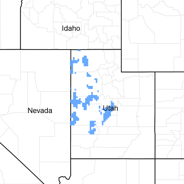
Figure 1. Mapped extent
Areas shown in blue indicate the maximum mapped extent of this ecological site. Other ecological sites likely occur within the highlighted areas. It is also possible for this ecological site to occur outside of highlighted areas if detailed soil survey has not been completed or recently updated.
MLRA notes
Major Land Resource Area (MLRA): 028A–Ancient Lake Bonneville
MLRA 28A occurs in Utah (82 percent), Nevada (16 percent), and Idaho (2 percent). It encompasses approximately 36,775 square miles (95,246 square kilometers). A large area west and southwest of Great Salt Lake is a salty playa. This area is the farthest eastern extent of the Great Basin Section of the Basin and Range Province of the Intermontane Plateaus. It is an area of nearly level basins between widely separated mountain ranges trending north to south. The basins are bordered by long, gently sloping alluvial fans. The mountains are uplifted fault blocks with steep side slopes. Most of the valleys are closed basins containing sinks or playa lakes. Elevation ranges from 3,950 to 6,560 feet (1,204 to 2000 meters) in the basins and from 6,560 to 11,150 feet (1996 to 3398 meters) in the mountains. Much of the MLRA has alluvial valley fill and playa lakebed deposits at the surface from pluvial Lake Bonneville, which dominated this MLRA 13,000 years ago. A level line of remnant lake terraces on some mountain slopes indicates the former extent of this glacial lake. The Great Salt Lake is what remains of the pluvial lake.
Mountains in the interior of this MLRA consist of tilted blocks of marine sediments from Cambrian to Mississippian age with scattered outcrops of Tertiary continental sediments and volcanic rocks. The average annual precipitation is 5 to 12 inches (13 to 30 cm) in the valleys and ranges up to 49 inches (124 cm) in the mountains. Most of the rainfall in the southern LRU occurs as high-intensity, convective thunderstorms during the growing season (April through September). The driest period is from midsummer to early autumn in the northern LRU. Precipitation in winter typically occurs as snow. The average annual temperature is 39 to 53 °F (4 to 12 °C). The freeze-free period averages 165 days and ranges from 110 to 215 days, decreasing in length with increasing elevation. The dominant soil orders in this MLRA are Aridisols, Entisols, and Mollisols. Soils are dominantly in the mesic or frigid soil temperature regime, aridic or xeric soil moisture regime, and mixed mineralogy. The soils are generally well drained, loamy or loamy-skeletal, and very deep.
LRU notes
The Basin and Range North LRU exhibits dry summer with stronger xeric patterns than the Basin and Range South LRU. Ranges in the north LRU are about 50 percent Paleozoic sedimentary/metasedimentary (limestone/quartzite dominant) and about 10 percent Tertiary volcanics. The basin floors are between 4,200 and 5,100 feet (1,280 to 1,554 meters) in elevation. Pinyon and juniper sites have a greater percentage of Utah juniper (Juniperus osteosperma) in the plant community than pinyon pine (Pinus edulis or monophylla). The Basin and Range North have few semidesert ecological sites with Utah juniper. Cool season grasses, such as bluebunch wheatgrass (Pseudorogneria spicata), are dominant in the plant community, while warm season grasses are largely absent or a small component of the plant community.
Ecological site concept
The Semidesert Stony Loam (Black Sagebrush) site is found on fan remnants that have high rock fragments in soil surface and subsurface (surface texture is very gravelly sandy loam). The elevation of this site is between 4,500 and 6,600 feet on slopes that are 2 to 30 percent. The site is dominated by black sagebrush.
Associated sites
| R028AY215UT |
Semidesert Gravelly Loam (Wyoming Big Sagebrush) North This site can be found downslope. |
|---|---|
| R028AY230UT |
Semidesert Shallow Hardpan (Black Sagebrush) North This site occurs adjacent to this ecological site on alluvial fans or fan remnants where the soils are shallow from either a duripan or petrocalcic layer. |
| R028AY243UT |
Semidesert Shallow Loam (Wyoming Big Sagebrush) North This site occurs on shallow soils over fractured bedrock. |
Similar sites
| R028AY325UT |
Upland Shallow Loam (Black Sagebrush) This site occurs upslope to this ecological site where the soils are shallow. |
|---|
Table 1. Dominant plant species
| Tree |
Not specified |
|---|---|
| Shrub |
(1) Artemisia nova |
| Herbaceous |
(1) Achnatherum hymenoides |
Physiographic features
The Semidesert Stony Loam (Black Sagebrush) site is located on a broad range of physiographical features, the most common ones include fan terraces and remnants, alluvial fans, and hills. Slopes range from 2 to 30 percent but may occasionally be steeper. Runoff potential typically ranges from low to medium but may rarely be high. Sites are located between 4,500 to 6,600 feet in elevation.
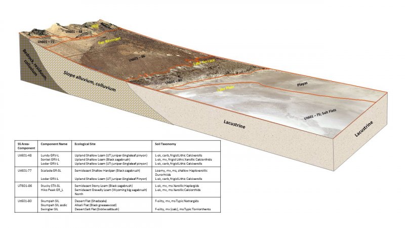
Figure 2.
Table 2. Representative physiographic features
| Landforms |
(1)
Fan remnant
(2) Fan terrace (3) Alluvial fan (4) Hill |
|---|---|
| Flooding frequency | None |
| Ponding frequency | None |
| Elevation | 4,500 – 6,600 ft |
| Slope | 2 – 30% |
| Aspect | Aspect is not a significant factor |
Climatic features
The climate of this site is dry subhumid and semiarid. It is characterized by cold, snowy winters and warm, dry summers. The average annual precipitation ranges from 11 to 15 inches. March, April and May are typically the wettest months with June, July and September being the driest. The most reliable sources of moisture for plant growth are the snow that accumulates over the winter, and spring rains. Summer thunderstorms are intermittent and sporadic in nature, and thus are not reliable sources of moisture to support vegetative growth on this site. The mean annual air temperature is 45 to 52 degrees. Mean Annual Soil Temperature: 49-54 degrees.
Table 3. Representative climatic features
| Frost-free period (characteristic range) | 81-103 days |
|---|---|
| Freeze-free period (characteristic range) | 124-144 days |
| Precipitation total (characteristic range) | 12-14 in |
| Frost-free period (actual range) | 71-109 days |
| Freeze-free period (actual range) | 120-155 days |
| Precipitation total (actual range) | 11-15 in |
| Frost-free period (average) | 92 days |
| Freeze-free period (average) | 135 days |
| Precipitation total (average) | 13 in |
Figure 3. Monthly precipitation range
Figure 4. Monthly minimum temperature range
Figure 5. Monthly maximum temperature range
Figure 6. Monthly average minimum and maximum temperature
Figure 7. Annual precipitation pattern
Figure 8. Annual average temperature pattern
Climate stations used
-
(1) EPHRAIM [USC00422578], Ephraim, UT
-
(2) MANTI [USC00425402], Manti, UT
-
(3) MORONI [USC00425837], Mount Pleasant, UT
-
(4) OAK CITY [USC00426357], Delta, UT
Influencing water features
There are no influencing water features.
Soil features
The soil is deep and well drained. It formed in alluvium derived mainly from igneous rock, limestone, quartzite, and rhyolite parent materials. The soil surface is 45 to 65 percent covered by pebbles, cobbles, or stones. Rock fragment content in the particle-size control section of the soil profile is 25 to 60 percent. The soil is mainly coarse textured and may show weak discontinuous cementation by silica or carbonates in some subhorizons. It is calcareous to the surface. Reaction is mildly alkaline to very strongly alkaline. Permeability is moderate to moderately rapid. Available water capacity is 1 to 5 inches.
Soil Survey Area: Soil Components:
Box Elder County - Western Part (UT601) Stucky; Tosser.
Tooele Area (UT611): Hiko Peak.
Millard County (UT618): Hiko Peak; Pober; Sanpete.
Sanpete Valley Area (UT627): Sanpete; Sigurd.
Beaver County Area (UT628): Elbboc, Eldgin, Glenwood, Hiko Peak, Sandpete, Sigurd, Stillman, Weirman.
Table 4. Representative soil features
| Parent material |
(1)
Alluvium
–
quartzite
|
|---|---|
| Surface texture |
(1) Very gravelly sandy loam (2) Very stony loam (3) Very cobbly sandy loam (4) Stony fine sandy loam |
| Drainage class | Well drained |
| Permeability class | Moderate to moderately rapid |
| Soil depth | 60 in |
| Surface fragment cover <=3" | 13 – 39% |
| Surface fragment cover >3" | 30% |
| Available water capacity (0-40in) |
1 – 5 in |
| Calcium carbonate equivalent (0-40in) |
3 – 30% |
| Electrical conductivity (0-40in) |
2 mmhos/cm |
| Sodium adsorption ratio (0-40in) |
13 |
| Soil reaction (1:1 water) (0-40in) |
7.4 – 9 |
| Subsurface fragment volume <=3" (Depth not specified) |
21 – 46% |
| Subsurface fragment volume >3" (Depth not specified) |
19% |
Ecological dynamics
The Semidesert Stony Loam (Black Sagebrush) site is found in the Great Salt Lake Area of the Basin and Range Ecological Provence. It developed under the natural ecological conditions found there, including the normal influences of native wildlife herbivory, fire and climate.
Plant species composition is typically dominated by black sagebrush. A wide mixture of other shrubs including Nevada ephedra and shadscale are also commonly found. Bluebunch wheatgrass and Indian ricegrass are the most prominent herbaceous species. Needle-and thread, western wheatgrass, and James galleta are other common perennial grasses.
The Semidesert Stony Loam (Black Sagebrush) ecological site has been grazed by domestic livestock since they were first introduced into the area in the mid to late 1800's. This introduction of livestock, mainly cattle and sheep, including the use of fencing to control those stock, and the development of reliable water sources, has in places altered the historic disturbance regimes associated with this ecological site. Improper livestock grazing that includes season long grazing and/or heavy stocking rates over long periods of time, will likely cause this site to depart from the reference plant community.
Periodic fire naturally occurred on this site with a burn period estimated at 80 to 90 years. Disturbances such as improper grazing, poorly designed brush treatments and OHV misuse can put this site at risk of entering a shorter burn cycle by allowing invasive annuals to enter the system. These annuals can produce flashy fuel loads which easily burn. Cheatgrass, Halogeton, various mustard species, Alyssum, and Russian thistle are most likely to invade this site. These and other invasive weed species are capable of establishing themselves on this site, however, even in the absence of disturbance, but rarely increase to a point where they dominate the community.
As this sites ecological condition deteriorates, palatable perennial grasses and winterfat typically decrease while Wyoming big sagebrush, green rabbitbrush, and less palatable grasses and forbs increase.
Management practices that maintain or improve rangeland vegetation include prescribed grazing, and the proper location of water and fencing developments. Severe drought may adversely affect the production of the herbaceous perennial vegetation.
Suitability for rangeland seeding is only fair on this site because of the stony soils. This practice is being used, however, over large areas to improve forage quality and to control erosion. Treated pastures, including sagebrush spraying, brush beating, and juniper chaining are commonly found throughout this site. These treated areas are typically seeded to adapted forage plants including crested wheatgrass and intermediate wheatgrass.
Where vegetative communities have been impacted by changes in management or natural influences that moved them from one ecological state to another, a return to previous states is often not possible. The amount of energy needed to affect desired vegetative shifts on this site depends on both its present biotic and abiotic features and the desired results.
The following State and Transition diagram shows some of the most commonly occurring plant communities found on this ecological site. These plant communities may not represent every possibility, but they are the most prevalent and repeatable. As more data are collected, some of these plant communities may be revised or removed, and new ones may be added. This model was developed using range data collected over the last 40 years in MLRA D28A in western Utah. Both ocular and measured data was collected and utilized.
State and transition model

Figure 9. R028AY252UT
More interactive model formats are also available.
View Interactive Models
More interactive model formats are also available.
View Interactive Models
Click on state and transition labels to scroll to the respective text
Ecosystem states
State 1 submodel, plant communities
State 2 submodel, plant communities
State 3 submodel, plant communities
State 1
Reference State
The Reference State describes the various biotic communities that are expected to be found on this ecological site under natural conditions. The Reference State has a well developed shrub layer with black sagebrush dominating. Nevada ephedra and shadscale are other common shrub species. Bluebunch wheatgrass and Idaho fescue are co-dominant herbaceous species with needle-and-thread and bottlebrush squirreltail commonly occurring. Other native grasses, forbs, and shrubs will often produce a significant portion of vegetative composition in the plant community. The Reference State is self-sustaining and resistant to change. The primary natural disturbance mechanisms are wildlife population densities which can affect the shrub layer composition, weather fluctuations, and fire period. Definitions: Reference State: Natural plant communities as influenced by shrub canopy density, long term weather fluctuations, and periodic fire. Indicators: These communities are dominated by black sagebrush, Idaho fescue and bluebunch wheatgrass. The density of the shrub canopy determines the amount and composition of the other native species present in the community. Feedbacks: Natural fluctuations in weather patterns that allow for a self-sustaining shrub and native grass community. Prolonged drought, an increase in fire frequency, or other disturbances may allow for the establishment of invasive species. At-risk Community Phase: All communities are at risk when native plants are stressed and conditions are created that may allow invasive plants to establish. Trigger: The establishment of invasive plant species.
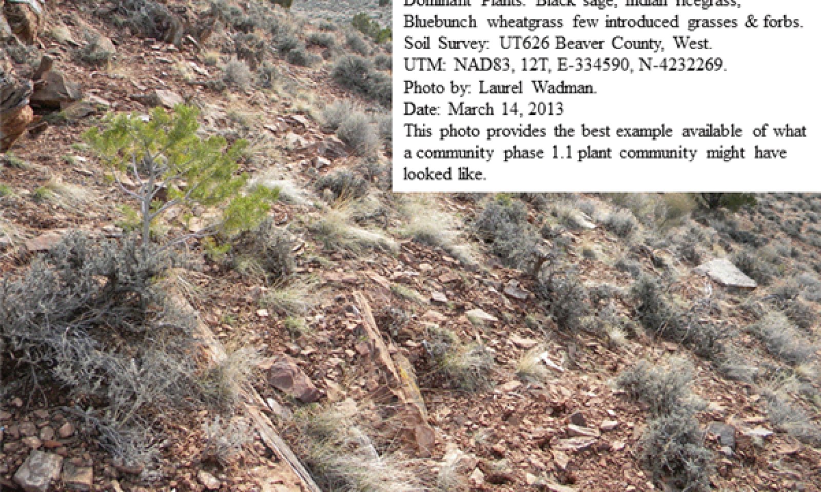
Community 1.1
Black Sagebrush/Bluebunch Wheatgrass

Figure 10. Community Phase 1.1
This reference community is dominated by black sagebrush. Other significant shrubs include shadscale and Nevada ephedra. Bluebunch wheatgrass and Indian ricegrass co-dominate the herbaceous layer. Other commonly occurring grasses include Nevada bluegrass, needle-and-thread and bottlebrush squirreltail. This site is mature and may be nearing the end of its natural fire cycle. The sites vegetative composition by air-dry weight is approximately 40 percent perennial grasses, 10 percent forbs, and 50 percent shrubs.
Figure 11. Annual production by plant type (representative values) or group (midpoint values)
Table 5. Annual production by plant type
| Plant type | Low (lb/acre) |
Representative value (lb/acre) |
High (lb/acre) |
|---|---|---|---|
| Shrub/Vine | 180 | 300 | 350 |
| Grass/Grasslike | 180 | 240 | 270 |
| Forb | 40 | 60 | 80 |
| Total | 400 | 600 | 700 |
Figure 12. Plant community growth curve (percent production by month). UT2521, PNC. Excellent Condition.
| Jan | Feb | Mar | Apr | May | Jun | Jul | Aug | Sep | Oct | Nov | Dec |
|---|---|---|---|---|---|---|---|---|---|---|---|
| J | F | M | A | M | J | J | A | S | O | N | D |
| 0 | 0 | 5 | 15 | 40 | 30 | 5 | 5 | 0 | 0 | 0 | 0 |
Figure 13. Plant community growth curve (percent production by month). UT2522, Good Condition NO. 1. Bluegrass, Black Sagebrush.
| Jan | Feb | Mar | Apr | May | Jun | Jul | Aug | Sep | Oct | Nov | Dec |
|---|---|---|---|---|---|---|---|---|---|---|---|
| J | F | M | A | M | J | J | A | S | O | N | D |
| 0 | 0 | 0 | 20 | 50 | 20 | 5 | 5 | 0 | 0 | 0 | 0 |
Community 1.2
Bluebunch Wheatgrass, Herbaceous Grass
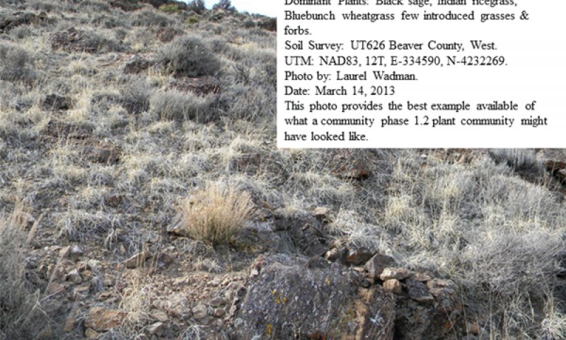
Figure 14. Community Phase 1.2
The visual aspect of this reference community is dominated by bluebunch wheatgrass, Indian ricegrass and other native perennial grasses. Significant shrubs are still present and typically include black sagebrush, Nevada ephedra and shadscale and various horsebrush species. Other commonly occurring grasses include needle-and-thread and bottlebrush squirreltail. This site is early in its natural fire cycle and a slow transition from herbaceous species to woody species is occurring. The sites vegetative composition by air-dry weight is approximately 60 percent perennial grasses, 10 percent forbs, and 30 percent shrubs.
Figure 15. Annual production by plant type (representative values) or group (midpoint values)
Table 6. Annual production by plant type
| Plant type | Low (lb/acre) |
Representative value (lb/acre) |
High (lb/acre) |
|---|---|---|---|
| Shrub/Vine | 180 | 300 | 350 |
| Grass/Grasslike | 180 | 240 | 270 |
| Forb | 40 | 60 | 80 |
| Total | 400 | 600 | 700 |
Figure 16. Plant community growth curve (percent production by month). UT2521, PNC. Excellent Condition.
| Jan | Feb | Mar | Apr | May | Jun | Jul | Aug | Sep | Oct | Nov | Dec |
|---|---|---|---|---|---|---|---|---|---|---|---|
| J | F | M | A | M | J | J | A | S | O | N | D |
| 0 | 0 | 5 | 15 | 40 | 30 | 5 | 5 | 0 | 0 | 0 | 0 |
Figure 17. Plant community growth curve (percent production by month). UT2522, Good Condition NO. 1. Bluegrass, Black Sagebrush.
| Jan | Feb | Mar | Apr | May | Jun | Jul | Aug | Sep | Oct | Nov | Dec |
|---|---|---|---|---|---|---|---|---|---|---|---|
| J | F | M | A | M | J | J | A | S | O | N | D |
| 0 | 0 | 0 | 20 | 50 | 20 | 5 | 5 | 0 | 0 | 0 | 0 |
Pathway 1.1a
Community 1.1 to 1.2
This community pathway occurs when weather patterns are within normal ranges and some level of fire reduces the black sagebrush canopy, significantly opening the site. This more open canopy allows understory vegetation to increase in production, and under some circumstances, flourish on the site. Proper livestock grazing during these periods can facilitate this process.
Pathway 1.2a
Community 1.2 to 1.1
This community pathway occurs when long-term drought and/or extended periods without fire allows canopies, mainly black sagebrush to significantly increase. This closing canopy event causes understory vegetation to be reduced and eventually nearly eliminated from the site. Drought alone can also reduce native perennial grass production and eventually eliminate some species from the system. Improper livestock grazing during these periods can facilitate this process.
State 2
Current Potential State
The Current Potential State is similar to the Reference Sate except that non-native species are now present. The Current Potential State describes the plant communities that may or have become established on this ecological site under various successional sequences and disturbance conditions. The state typically has a well developed shrub layer with black sagebrush often dominating. Shadscale and Nevada ephedra are other common shrub species. Bluebunch wheatgrass and Indian ricegrass are co-dominant herbaceous species with needle-and-thread, Nevada bluegrass, and other perennial grasses and forbs commonly found in abundance also. These other native grasses, forbs, and shrubs may produce significant composition in the plant community. Cheatgrass, Alyssum, bur buttercup, various mustard species, and other non-native species are present on the site and under certain circumstances, may visually dominate the sites aspect. The primary disturbance mechanisms are livestock grazing, shrub layer density; the amount of invasive species present; weather fluctuations; and fire. The Current Potential State is still self-sustaining but may be losing its resistance to change due to the impact of disturbances with less resilience following those disturbances. Definitions: Current Potential State: Plant communities influenced by shrub canopy density, long term weather fluctuations, grazing and periodic fire. Invasive species are present in various amounts. Indicators: A community dominated by black sagebrush and perennial grasses. The density of the shrub canopy determines the amount and composition of the other native and introduced grasses and forbs that may be present. Feedbacks: Natural fluctuations in weather patterns that allow for a self sustaining shrub and native grass community. Prolonged drought, more frequent fires, and/or other disturbances that may allow for the increase of invasive species. At-risk Community Phase: All communities are at risk when native plants are stressed and nutrients become available for invasive plants to increase. Trigger: A reduction of perennial grass and forb species combined with an increase of invasive plant species.
Community 2.1
Black Sagebrush/Bluebunch Wheatgrass/Invasive Weed
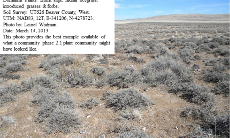
Figure 18. Community Phase 2.1
This community phase is dominated by black sagebrush. Other significant shrubs include shadscale and Nevada ephedra. Bluebunch wheatgrass and Indian ricegrass are the most prominent grasses. Other commonly occurring grasses include needle-and-thread, Nevada bluegrass and bottlebrush squirreltail. Non-native species are now present in the all plant communities and are expected to remain a permanent part of these communities. The sites vegetative composition by air-dry weight is approximately 40 percent perennial grasses, 15 percent forbs, and 45 percent shrubs.
Figure 19. Annual production by plant type (representative values) or group (midpoint values)
Table 7. Annual production by plant type
| Plant type | Low (lb/acre) |
Representative value (lb/acre) |
High (lb/acre) |
|---|---|---|---|
| Shrub/Vine | 180 | 300 | 350 |
| Grass/Grasslike | 180 | 240 | 270 |
| Forb | 40 | 60 | 80 |
| Total | 400 | 600 | 700 |
Figure 20. Plant community growth curve (percent production by month). UT2521, PNC. Excellent Condition.
| Jan | Feb | Mar | Apr | May | Jun | Jul | Aug | Sep | Oct | Nov | Dec |
|---|---|---|---|---|---|---|---|---|---|---|---|
| J | F | M | A | M | J | J | A | S | O | N | D |
| 0 | 0 | 5 | 15 | 40 | 30 | 5 | 5 | 0 | 0 | 0 | 0 |
Figure 21. Plant community growth curve (percent production by month). UT2522, Good Condition NO. 1. Bluegrass, Black Sagebrush.
| Jan | Feb | Mar | Apr | May | Jun | Jul | Aug | Sep | Oct | Nov | Dec |
|---|---|---|---|---|---|---|---|---|---|---|---|
| J | F | M | A | M | J | J | A | S | O | N | D |
| 0 | 0 | 0 | 20 | 50 | 20 | 5 | 5 | 0 | 0 | 0 | 0 |
Community 2.2
Black Sagebrush/Invasive Weed
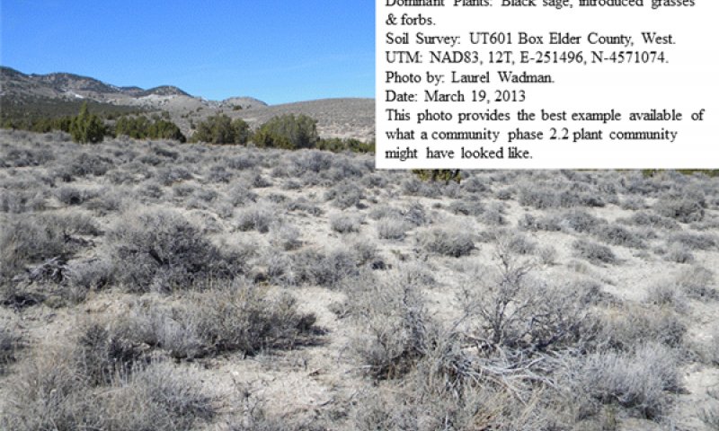
Figure 22. Cpmmunity Phase 2.2
This community phase is dominated by black sagebrush. Other significant shrubs include shadscale and Nevada ephedra. Bluebunch wheatgrass and Indian ricegrass and other native perennial herbaceous vegetation are much reduced or missing from the site. Non-native species are now present in the all plant communities and often dominate the understory. The sites vegetative composition by air-dry weight is approximately 20 percent perennial and annual grasses, 15 percent forbs, and 65 percent shrubs.
Figure 23. Annual production by plant type (representative values) or group (midpoint values)
Table 8. Annual production by plant type
| Plant type | Low (lb/acre) |
Representative value (lb/acre) |
High (lb/acre) |
|---|---|---|---|
| Shrub/Vine | 180 | 300 | 350 |
| Grass/Grasslike | 180 | 240 | 270 |
| Forb | 40 | 60 | 80 |
| Total | 400 | 600 | 700 |
Figure 24. Plant community growth curve (percent production by month). UT2521, PNC. Excellent Condition.
| Jan | Feb | Mar | Apr | May | Jun | Jul | Aug | Sep | Oct | Nov | Dec |
|---|---|---|---|---|---|---|---|---|---|---|---|
| J | F | M | A | M | J | J | A | S | O | N | D |
| 0 | 0 | 5 | 15 | 40 | 30 | 5 | 5 | 0 | 0 | 0 | 0 |
Figure 25. Plant community growth curve (percent production by month). UT2522, Good Condition NO. 1. Bluegrass, Black Sagebrush.
| Jan | Feb | Mar | Apr | May | Jun | Jul | Aug | Sep | Oct | Nov | Dec |
|---|---|---|---|---|---|---|---|---|---|---|---|
| J | F | M | A | M | J | J | A | S | O | N | D |
| 0 | 0 | 0 | 20 | 50 | 20 | 5 | 5 | 0 | 0 | 0 | 0 |
Community 2.3
Utah Juniper/Invasive Weed
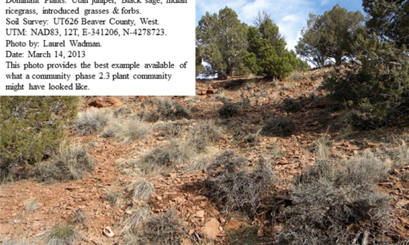
Figure 26. Community Phase 2.3
This community phase is dominated by an overstory of invading Utah juniper. Black sagebrush and other shrubs are present and may dominate the shrub layer. Bluebunch wheatgrass and Indian ricegrass and other native perennial herbaceous vegetation are much reduced or missing from the site. Non-native species are now present in the all plant communities and often dominate the herbaceous layer. The sites vegetative composition by air-dry weight is approximately 20 percent perennial and annual grasses, 15 percent forbs, 40 percent shrubs, and 25 percent trees.
Figure 27. Annual production by plant type (representative values) or group (midpoint values)
Table 9. Annual production by plant type
| Plant type | Low (lb/acre) |
Representative value (lb/acre) |
High (lb/acre) |
|---|---|---|---|
| Shrub/Vine | 180 | 300 | 350 |
| Grass/Grasslike | 180 | 240 | 270 |
| Forb | 40 | 60 | 80 |
| Total | 400 | 600 | 700 |
Figure 28. Plant community growth curve (percent production by month). UT2521, PNC. Excellent Condition.
| Jan | Feb | Mar | Apr | May | Jun | Jul | Aug | Sep | Oct | Nov | Dec |
|---|---|---|---|---|---|---|---|---|---|---|---|
| J | F | M | A | M | J | J | A | S | O | N | D |
| 0 | 0 | 5 | 15 | 40 | 30 | 5 | 5 | 0 | 0 | 0 | 0 |
Figure 29. Plant community growth curve (percent production by month). UT2522, Good Condition NO. 1. Bluegrass, Black Sagebrush.
| Jan | Feb | Mar | Apr | May | Jun | Jul | Aug | Sep | Oct | Nov | Dec |
|---|---|---|---|---|---|---|---|---|---|---|---|
| J | F | M | A | M | J | J | A | S | O | N | D |
| 0 | 0 | 0 | 20 | 50 | 20 | 5 | 5 | 0 | 0 | 0 | 0 |
Pathway 2.1a
Community 2.1 to 2.2
This community pathway occurs when long-term drought and/or extended periods without fire allows canopies, mainly black sagebrush, to significantly increase. This closing canopy event causes understory vegetation to be reduced and eventually, nearly eliminated from the site. Drought alone can also reduce native perennial grass production and eventually eliminate some species from the system. Improper livestock grazing during these periods can facilitate this process.
Pathway 2.2a
Community 2.2 to 2.1
This community pathway occurs when weather patterns are within normal ranges and some level of fire reduces the black sagebrush canopy, significantly opening the site. This more open canopy allows understory vegetation to increase in production. Proper livestock grazing during these periods can facilitate this process.
Pathway 2.2b
Community 2.2 to 2.3
This community pathway occurs when long-term drought and/or extended periods without fire allows Utah juniper to invade and eventually dominate the site. Black sagebrush is still significant in the shrub layer. This closing canopy causes understory vegetation to be reduced and eventually, nearly eliminated from the site. Drought alone can also reduce native perennial grass production and eventually eliminate some species from the system. Improper livestock grazing during these periods can facilitate this process.
Pathway 2.3a
Community 2.3 to 2.2
This community pathway occurs when fire reduces or removes the Utah juniper canopy and lessens the amount of black sagebrush canopy on the site. This more open canopy allows understory vegetation to increase in production. Improper livestock grazing during these periods can favor invasive annuals over perennial species.
State 3
Mechanically Altered State
The Mechanically Altered State describes plant community phases that have been mechanically treated to remove black sagebrush and/or Utah juniper. Common treatment methods include sagebrush spraying, brush-beating, and where juniper invasion has occurred, chaining. These treated pastures are then typically seeded to introduced forage species such as intermediate or crested wheatgrass, or managed to allow native perennial grasses to recover. Invasive weedy species, including cheatgrass, Halogeton, Alyssum, bur buttercup, various mustard species, and other non-native species, are present and, in some cares, may visually dominate the sites herbaceous layer. On pastures where seedings fail or native species do not respond to management, the site is often covered with annuals which can prevent site recovery and may periodically burn and re-burn. The primary disturbance mechanisms include; the amount of of invasive herbaceous species present; weather fluctuations, and fire patterns. This state may have lost its resistance to change due to the impact of these disturbances and has less resilience following those disturbances. Definitions: Mechanically Altered State: Plant communities that have been manipulated to remove black sagebrush and/or Utah juniper; long term weather fluctuations; and periodic fire. Indicators: The composition of the herbaceous community determines any additional treatment needs including range seeding and/or proper grazing management to allow native and introduced grasses and forbs to recover. Feedbacks: Natural fluctuations in weather patterns that impact herbaceous communities. Prolonged drought, less frequent fire, and/or other disturbances that allow for the increase of all invasive species. At-risk Community Phase: All communities are at risk when native plants are stressed and nutrients become available for invasive plants to increase. Trigger: A reduction of perennial grass and forb species combined with an increase of invasive plant species.
Community 3.1
Burned/Sprayed - Perennial Grass
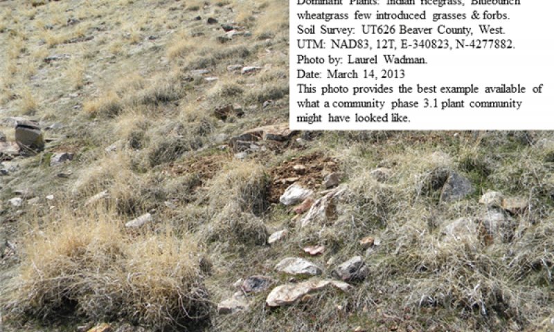
Figure 30. Community Phase 3.1
Site has been burned or sprayed to remove black sagebrush. Nevada ephedra, shadscale, and other shrubs may also be removed. Various amounts of native grasses and forbs may still be present but at reduced levels. Site may be managed to allow these species to recover. Where sufficient natives are not present, the site is typically seeded to crested or intermediate wheatgrass. Non-native species are present on the site and will be present in the seeded community. Vegetative composition by air-dry weight is approximately 75 percent grasses and introduced weedy species, 10 percent forbs, and 15 percent shrubs.
Figure 31. Annual production by plant type (representative values) or group (midpoint values)
Table 10. Annual production by plant type
| Plant type | Low (lb/acre) |
Representative value (lb/acre) |
High (lb/acre) |
|---|---|---|---|
| Shrub/Vine | 180 | 300 | 350 |
| Grass/Grasslike | 180 | 240 | 270 |
| Forb | 40 | 60 | 80 |
| Total | 400 | 600 | 700 |
Figure 32. Plant community growth curve (percent production by month). UT2521, PNC. Excellent Condition.
| Jan | Feb | Mar | Apr | May | Jun | Jul | Aug | Sep | Oct | Nov | Dec |
|---|---|---|---|---|---|---|---|---|---|---|---|
| J | F | M | A | M | J | J | A | S | O | N | D |
| 0 | 0 | 5 | 15 | 40 | 30 | 5 | 5 | 0 | 0 | 0 | 0 |
Figure 33. Plant community growth curve (percent production by month). UT2522, Good Condition NO. 1. Bluegrass, Black Sagebrush.
| Jan | Feb | Mar | Apr | May | Jun | Jul | Aug | Sep | Oct | Nov | Dec |
|---|---|---|---|---|---|---|---|---|---|---|---|
| J | F | M | A | M | J | J | A | S | O | N | D |
| 0 | 0 | 0 | 20 | 50 | 20 | 5 | 5 | 0 | 0 | 0 | 0 |
Community 3.2
Annual/Invasive Weed
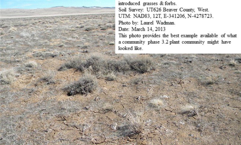
Figure 34. Community Phase 3.2
This community phase is found following successful burning or spraying to remove black sagebrush or chaining to remove Utah juniper. Other shrubs, including Nevada ephedra, winterfat and shadscale may also be removed from the site. Native herbaceous species such as bluebunch wheatgrass, Indian ricegrass, needle-and-thread, and James galleta are either much reduced or missing. Site is either not seeded, or the seeding is a failure. Non-native species are present and produce most of the sites herbage. Annuals such as cheatgrass, Russian thistle and various mustards readily burn and re-burn every few years. This short burn cycle may lock the site into a potentially permanent annual weed community phase. This site has little value for forage production. Vegetative composition by air-dry weight is approximately 60 percent annual grasses, 10 percent perennial grasses, 20 percent annual forbs, and 10 percent shrubs.
Figure 35. Annual production by plant type (representative values) or group (midpoint values)
Table 11. Annual production by plant type
| Plant type | Low (lb/acre) |
Representative value (lb/acre) |
High (lb/acre) |
|---|---|---|---|
| Shrub/Vine | 180 | 300 | 350 |
| Grass/Grasslike | 180 | 240 | 270 |
| Forb | 40 | 60 | 80 |
| Total | 400 | 600 | 700 |
Figure 36. Plant community growth curve (percent production by month). UT2522, Good Condition NO. 1. Bluegrass, Black Sagebrush.
| Jan | Feb | Mar | Apr | May | Jun | Jul | Aug | Sep | Oct | Nov | Dec |
|---|---|---|---|---|---|---|---|---|---|---|---|
| J | F | M | A | M | J | J | A | S | O | N | D |
| 0 | 0 | 0 | 20 | 50 | 20 | 5 | 5 | 0 | 0 | 0 | 0 |
Figure 37. Plant community growth curve (percent production by month). UT2521, PNC. Excellent Condition.
| Jan | Feb | Mar | Apr | May | Jun | Jul | Aug | Sep | Oct | Nov | Dec |
|---|---|---|---|---|---|---|---|---|---|---|---|
| J | F | M | A | M | J | J | A | S | O | N | D |
| 0 | 0 | 5 | 15 | 40 | 30 | 5 | 5 | 0 | 0 | 0 | 0 |
Community 3.3
Juniper Chaining - Perennial Grass
Site has been burned or chained to remove Utah juniper and possibly black sagebrush. Nevada ephedra, shadscale and other shrubs may also be removed. Various amounts of native grasses and forbs may still be present but at reduced levels. Site may be managed to allow these species to recover. Where sufficient natives are not present, the site is typically seeded to crested or intermediate wheatgrass. Non-native species are present on the site and will be present in the seeded community. The sites vegetative composition by air-dry weight is approximately 75 percent grasses and introduced weedy species, 10 percent forbs, 15 percent shrubs and trees.
Figure 38. Annual production by plant type (representative values) or group (midpoint values)
Table 12. Annual production by plant type
| Plant type | Low (lb/acre) |
Representative value (lb/acre) |
High (lb/acre) |
|---|---|---|---|
| Shrub/Vine | 180 | 300 | 350 |
| Grass/Grasslike | 180 | 240 | 270 |
| Forb | 40 | 60 | 80 |
| Total | 400 | 600 | 700 |
Figure 39. Plant community growth curve (percent production by month). UT2521, PNC. Excellent Condition.
| Jan | Feb | Mar | Apr | May | Jun | Jul | Aug | Sep | Oct | Nov | Dec |
|---|---|---|---|---|---|---|---|---|---|---|---|
| J | F | M | A | M | J | J | A | S | O | N | D |
| 0 | 0 | 5 | 15 | 40 | 30 | 5 | 5 | 0 | 0 | 0 | 0 |
Figure 40. Plant community growth curve (percent production by month). UT2522, Good Condition NO. 1. Bluegrass, Black Sagebrush.
| Jan | Feb | Mar | Apr | May | Jun | Jul | Aug | Sep | Oct | Nov | Dec |
|---|---|---|---|---|---|---|---|---|---|---|---|
| J | F | M | A | M | J | J | A | S | O | N | D |
| 0 | 0 | 0 | 20 | 50 | 20 | 5 | 5 | 0 | 0 | 0 | 0 |
Pathway 3.1a
Community 3.1 to 3.2
This community pathway occurs when fire removes the remaining black sagebrush canopy from the site. Improper livestock grazing, especially when combined with droughty conditions, can favor invasive annuals over perennial species during these periods.
Pathway 3.2a
Community 3.2 to 3.1
This community pathway occurs when weather patterns are within normal ranges and fire does not occur on the site. This combination of events allows black sagebrush canopy to increase on the site. Proper livestock grazing during these periods can facilitate this process.
Pathway 3.2b
Community 3.2 to 3.3
This community pathway occurs when weather patterns are within normal ranges and some level of fire reduces the black sagebrush canopy, significantly opening the site. This more open canopy allows understory vegetation to increase in production. Proper livestock grazing during these periods can facilitate this process.
Pathway 3.3a
Community 3.3 to 3.2
This community pathway occurs when fire removes the remaining black sagebrush and Utah juniper canopies from the site. Improper livestock grazing, especially when combined with droughty conditions, can favor invasive annuals over perennial species during these periods.
Transition T1A
State 1 to 2
This transitional pathway occurs when any combination of improper livestock grazing, prolonged drought, or other disturbance causes the perennial herbaceous community to become significantly reduced allowing non-native species such as cheatgrass, Halogeton, Alyssum, Russian thistle, and other invasive weeds to become established. Broom snakeweed may also increase during this time. Once invasive species occupy the site, a threshold has been crossed. Cheatgrass, however, has been known to become established in healthy communities on this site.
Transition T2A
State 2 to 3
This transitional pathway occurs when the site is sprayed, brush beat, or disked to remove black sagebrush and other unwanted shrubs. Where Utah juniper has invaded, chaining has been completed. The perennial herbaceous community may respond positively to this treatment if proper management is applied. Where insufficient desirable forage species are not available, introduced species are seeded onto the site. Non-native species such as cheatgrass, Halogeton, Alyssum, Russian thistle and other invasive weeds are also present. Broom snakeweed may also increase during this time.
Additional community tables
Table 13. Community 1.1 plant community composition
| Group | Common name | Symbol | Scientific name | Annual production (lb/acre) | Foliar cover (%) | |
|---|---|---|---|---|---|---|
|
Grass/Grasslike
|
||||||
| 1 | Primary Grasses | 200–250 | ||||
| bluebunch wheatgrass | PSSP6 | Pseudoroegneria spicata | 60–100 | – | ||
| Indian ricegrass | ACHY | Achnatherum hymenoides | 60–100 | – | ||
| squirreltail | ELEL5 | Elymus elymoides | 30–50 | – | ||
| James' galleta | PLJA | Pleuraphis jamesii | 30–50 | – | ||
| 4 | Secondary Grasses | 40–80 | ||||
| needle and thread | HECO26 | Hesperostipa comata | 30–60 | – | ||
| prairie Junegrass | KOMA | Koeleria macrantha | 20–30 | – | ||
| western wheatgrass | PASM | Pascopyrum smithii | 20–30 | – | ||
| muttongrass | POFE | Poa fendleriana | 20–30 | – | ||
| Sandberg bluegrass | POSE | Poa secunda | 20–30 | – | ||
| sand dropseed | SPCR | Sporobolus cryptandrus | 20–30 | – | ||
| Grass, perennial | 2GP | Grass, perennial | 20–30 | – | ||
| Letterman's needlegrass | ACLE9 | Achnatherum lettermanii | 20–30 | – | ||
| purple threeawn | ARPU9 | Aristida purpurea | 20–30 | – | ||
| blue grama | BOGR2 | Bouteloua gracilis | 20–30 | – | ||
| slender wheatgrass | ELTR7 | Elymus trachycaulus | 20–30 | – | ||
|
Forb
|
||||||
| 2 | Primary Forbs | 30–60 | ||||
| Forb, annual | 2FA | Forb, annual | 10–20 | – | ||
| Forb, perennial | 2FP | Forb, perennial | 10–20 | – | ||
| common yarrow | ACMI2 | Achillea millefolium | 10–20 | – | ||
| low pussytoes | ANDI2 | Antennaria dimorpha | 10–20 | – | ||
| Utah milkvetch | ASUT | Astragalus utahensis | 10–20 | – | ||
| Hooker's balsamroot | BAHO | Balsamorhiza hookeri | 10–20 | – | ||
| northwestern Indian paintbrush | CAAN7 | Castilleja angustifolia | 10–20 | – | ||
| maiden blue eyed Mary | COPA3 | Collinsia parviflora | 10–20 | – | ||
| bastard toadflax | COUM | Comandra umbellata | 10–20 | – | ||
| tall annual willowherb | EPBR3 | Epilobium brachycarpum | 10–20 | – | ||
| cushion buckwheat | EROV | Eriogonum ovalifolium | 10–20 | – | ||
| shaggy fleabane | ERPU2 | Erigeron pumilus | 10–20 | – | ||
| hairy false goldenaster | HEVI4 | Heterotheca villosa | 10–20 | – | ||
| western waterleaf | HYOC | Hydrophyllum occidentale | 10–20 | – | ||
| western stoneseed | LIRU4 | Lithospermum ruderale | 10–20 | – | ||
| tailcup lupine | LUCA | Lupinus caudatus | 10–20 | – | ||
| hoary tansyaster | MACA2 | Machaeranthera canescens | 10–20 | – | ||
| pale evening primrose | OEPA | Oenothera pallida | 10–20 | – | ||
| Tolmie's owl's-clover | ORTO | Orthocarpus tolmiei | 10–20 | – | ||
| low beardtongue | PEHU | Penstemon humilis | 10–20 | – | ||
| spiny phlox | PHHO | Phlox hoodii | 10–20 | – | ||
| longleaf phlox | PHLO2 | Phlox longifolia | 10–20 | – | ||
| old-man-in-the-Spring | SEVU | Senecio vulgaris | 10–20 | – | ||
| gooseberryleaf globemallow | SPGR2 | Sphaeralcea grossulariifolia | 10–20 | – | ||
| stemless mock goldenweed | STAC | Stenotus acaulis | 10–20 | – | ||
| yellow salsify | TRDU | Tragopogon dubius | 10–20 | – | ||
| salsify | TRPO | Tragopogon porrifolius | 10–20 | – | ||
|
Shrub/Vine
|
||||||
| 3 | Primary Shrubs | 250–300 | ||||
| black sagebrush | ARNO4 | Artemisia nova | 180–210 | – | ||
| shadscale saltbush | ATCO | Atriplex confertifolia | 60–90 | – | ||
| Nevada jointfir | EPNE | Ephedra nevadensis | 60–90 | – | ||
| winterfat | KRLA2 | Krascheninnikovia lanata | 60–90 | – | ||
| 5 | Secondary Shrubs | 30–60 | ||||
| Shrub (>.5m) | 2SHRUB | Shrub (>.5m) | 20–40 | – | ||
| Wyoming big sagebrush | ARTRW8 | Artemisia tridentata ssp. wyomingensis | 20–40 | – | ||
| fourwing saltbush | ATCA2 | Atriplex canescens | 20–40 | – | ||
| yellow rabbitbrush | CHVI8 | Chrysothamnus viscidiflorus | 20–40 | – | ||
| slender buckwheat | ERMI4 | Eriogonum microthecum | 20–40 | – | ||
| rubber rabbitbrush | ERNA10 | Ericameria nauseosa | 20–40 | – | ||
| spiny hopsage | GRSP | Grayia spinosa | 20–40 | – | ||
| broom snakeweed | GUSA2 | Gutierrezia sarothrae | 20–40 | – | ||
| plains pricklypear | OPPO | Opuntia polyacantha | 20–40 | – | ||
| bud sagebrush | PIDE4 | Picrothamnus desertorum | 20–40 | – | ||
| Mexican cliffrose | PUME | Purshia mexicana | 20–40 | – | ||
| spineless horsebrush | TECA2 | Tetradymia canescens | 20–40 | – | ||
| Nuttall's horsebrush | TENU2 | Tetradymia nuttallii | 20–40 | – | ||
| shortspine horsebrush | TESP2 | Tetradymia spinosa | 20–40 | – | ||
Table 14. Community 1.2 plant community composition
| Group | Common name | Symbol | Scientific name | Annual production (lb/acre) | Foliar cover (%) | |
|---|---|---|---|---|---|---|
|
Grass/Grasslike
|
||||||
| 1 | Primary Grasses | 300–350 | ||||
| bluebunch wheatgrass | PSSP6 | Pseudoroegneria spicata | 100–140 | – | ||
| Indian ricegrass | ACHY | Achnatherum hymenoides | 100–140 | – | ||
| squirreltail | ELEL5 | Elymus elymoides | 30–50 | – | ||
| James' galleta | PLJA | Pleuraphis jamesii | 30–50 | – | ||
| 4 | Secondary Grasses | 40–80 | ||||
| needle and thread | HECO26 | Hesperostipa comata | 30–60 | – | ||
| prairie Junegrass | KOMA | Koeleria macrantha | 20–30 | – | ||
| western wheatgrass | PASM | Pascopyrum smithii | 20–30 | – | ||
| muttongrass | POFE | Poa fendleriana | 20–30 | – | ||
| Sandberg bluegrass | POSE | Poa secunda | 20–30 | – | ||
| sand dropseed | SPCR | Sporobolus cryptandrus | 20–30 | – | ||
| Grass, perennial | 2GP | Grass, perennial | 20–30 | – | ||
| Letterman's needlegrass | ACLE9 | Achnatherum lettermanii | 20–30 | – | ||
| purple threeawn | ARPU9 | Aristida purpurea | 20–30 | – | ||
| blue grama | BOGR2 | Bouteloua gracilis | 20–30 | – | ||
| slender wheatgrass | ELTR7 | Elymus trachycaulus | 20–30 | – | ||
|
Forb
|
||||||
| 2 | Primary Forbs | 30–60 | ||||
| Forb, annual | 2FA | Forb, annual | 10–20 | – | ||
| Forb, perennial | 2FP | Forb, perennial | 10–20 | – | ||
| common yarrow | ACMI2 | Achillea millefolium | 10–20 | – | ||
| low pussytoes | ANDI2 | Antennaria dimorpha | 10–20 | – | ||
| Utah milkvetch | ASUT | Astragalus utahensis | 10–20 | – | ||
| Hooker's balsamroot | BAHO | Balsamorhiza hookeri | 10–20 | – | ||
| northwestern Indian paintbrush | CAAN7 | Castilleja angustifolia | 10–20 | – | ||
| maiden blue eyed Mary | COPA3 | Collinsia parviflora | 10–20 | – | ||
| bastard toadflax | COUM | Comandra umbellata | 10–20 | – | ||
| tall annual willowherb | EPBR3 | Epilobium brachycarpum | 10–20 | – | ||
| cushion buckwheat | EROV | Eriogonum ovalifolium | 10–20 | – | ||
| shaggy fleabane | ERPU2 | Erigeron pumilus | 10–20 | – | ||
| hairy false goldenaster | HEVI4 | Heterotheca villosa | 10–20 | – | ||
| western waterleaf | HYOC | Hydrophyllum occidentale | 10–20 | – | ||
| western stoneseed | LIRU4 | Lithospermum ruderale | 10–20 | – | ||
| tailcup lupine | LUCA | Lupinus caudatus | 10–20 | – | ||
| hoary tansyaster | MACA2 | Machaeranthera canescens | 10–20 | – | ||
| pale evening primrose | OEPA | Oenothera pallida | 10–20 | – | ||
| Tolmie's owl's-clover | ORTO | Orthocarpus tolmiei | 10–20 | – | ||
| low beardtongue | PEHU | Penstemon humilis | 10–20 | – | ||
| spiny phlox | PHHO | Phlox hoodii | 10–20 | – | ||
| longleaf phlox | PHLO2 | Phlox longifolia | 10–20 | – | ||
| old-man-in-the-Spring | SEVU | Senecio vulgaris | 10–20 | – | ||
| gooseberryleaf globemallow | SPGR2 | Sphaeralcea grossulariifolia | 10–20 | – | ||
| stemless mock goldenweed | STAC | Stenotus acaulis | 10–20 | – | ||
| yellow salsify | TRDU | Tragopogon dubius | 10–20 | – | ||
| salsify | TRPO | Tragopogon porrifolius | 10–20 | – | ||
|
Shrub/Vine
|
||||||
| 3 | Primary Shrubs | 150–200 | ||||
| black sagebrush | ARNO4 | Artemisia nova | 80–120 | – | ||
| winterfat | KRLA2 | Krascheninnikovia lanata | 60–90 | – | ||
| shadscale saltbush | ATCO | Atriplex confertifolia | 30–60 | – | ||
| Nevada jointfir | EPNE | Ephedra nevadensis | 30–60 | – | ||
| 5 | Secondary Shrubs | 30–60 | ||||
| Shrub (>.5m) | 2SHRUB | Shrub (>.5m) | 20–40 | – | ||
| Wyoming big sagebrush | ARTRW8 | Artemisia tridentata ssp. wyomingensis | 20–40 | – | ||
| fourwing saltbush | ATCA2 | Atriplex canescens | 20–40 | – | ||
| yellow rabbitbrush | CHVI8 | Chrysothamnus viscidiflorus | 20–40 | – | ||
| slender buckwheat | ERMI4 | Eriogonum microthecum | 20–40 | – | ||
| rubber rabbitbrush | ERNA10 | Ericameria nauseosa | 20–40 | – | ||
| spiny hopsage | GRSP | Grayia spinosa | 20–40 | – | ||
| broom snakeweed | GUSA2 | Gutierrezia sarothrae | 20–40 | – | ||
| plains pricklypear | OPPO | Opuntia polyacantha | 20–40 | – | ||
| bud sagebrush | PIDE4 | Picrothamnus desertorum | 20–40 | – | ||
| Mexican cliffrose | PUME | Purshia mexicana | 20–40 | – | ||
| spineless horsebrush | TECA2 | Tetradymia canescens | 20–40 | – | ||
| Nuttall's horsebrush | TENU2 | Tetradymia nuttallii | 20–40 | – | ||
| shortspine horsebrush | TESP2 | Tetradymia spinosa | 20–40 | – | ||
Table 15. Community 2.1 plant community composition
| Group | Common name | Symbol | Scientific name | Annual production (lb/acre) | Foliar cover (%) | |
|---|---|---|---|---|---|---|
|
Grass/Grasslike
|
||||||
| 1 | Primary Grasses | 200–250 | ||||
| bluebunch wheatgrass | PSSP6 | Pseudoroegneria spicata | 60–100 | – | ||
| Indian ricegrass | ACHY | Achnatherum hymenoides | 60–100 | – | ||
| squirreltail | ELEL5 | Elymus elymoides | 30–50 | – | ||
| James' galleta | PLJA | Pleuraphis jamesii | 30–50 | – | ||
| 4 | Secondary Grasses | 40–80 | ||||
| cheatgrass | BRTE | Bromus tectorum | 50–80 | – | ||
| needle and thread | HECO26 | Hesperostipa comata | 30–60 | – | ||
| red brome | BRRU2 | Bromus rubens | 30–40 | – | ||
| sixweeks fescue | VUOC | Vulpia octoflora | 30–40 | – | ||
| bulbous bluegrass | POBU | Poa bulbosa | 30–40 | – | ||
| muttongrass | POFE | Poa fendleriana | 20–30 | – | ||
| Sandberg bluegrass | POSE | Poa secunda | 20–30 | – | ||
| sand dropseed | SPCR | Sporobolus cryptandrus | 20–30 | – | ||
| prairie Junegrass | KOMA | Koeleria macrantha | 20–30 | – | ||
| western wheatgrass | PASM | Pascopyrum smithii | 20–30 | – | ||
| slender wheatgrass | ELTR7 | Elymus trachycaulus | 20–30 | – | ||
| Grass, perennial | 2GP | Grass, perennial | 20–30 | – | ||
| Letterman's needlegrass | ACLE9 | Achnatherum lettermanii | 20–30 | – | ||
| purple threeawn | ARPU9 | Aristida purpurea | 20–30 | – | ||
| blue grama | BOGR2 | Bouteloua gracilis | 20–30 | – | ||
|
Forb
|
||||||
| 2 | Primary Forbs | 30–60 | ||||
| Forb, annual | 2FA | Forb, annual | 10–20 | – | ||
| Forb, perennial | 2FP | Forb, perennial | 10–20 | – | ||
| common yarrow | ACMI2 | Achillea millefolium | 10–20 | – | ||
| low pussytoes | ANDI2 | Antennaria dimorpha | 10–20 | – | ||
| Utah milkvetch | ASUT | Astragalus utahensis | 10–20 | – | ||
| Hooker's balsamroot | BAHO | Balsamorhiza hookeri | 10–20 | – | ||
| northwestern Indian paintbrush | CAAN7 | Castilleja angustifolia | 10–20 | – | ||
| curveseed butterwort | CETE5 | Ceratocephala testiculata | 10–20 | – | ||
| lambsquarters | CHAL7 | Chenopodium album | 10–20 | – | ||
| crossflower | CHTE2 | Chorispora tenella | 10–20 | – | ||
| maiden blue eyed Mary | COPA3 | Collinsia parviflora | 10–20 | – | ||
| bastard toadflax | COUM | Comandra umbellata | 10–20 | – | ||
| western tansymustard | DEPI | Descurainia pinnata | 10–20 | – | ||
| herb sophia | DESO2 | Descurainia sophia | 10–20 | – | ||
| tall annual willowherb | EPBR3 | Epilobium brachycarpum | 10–20 | – | ||
| cushion buckwheat | EROV | Eriogonum ovalifolium | 10–20 | – | ||
| shaggy fleabane | ERPU2 | Erigeron pumilus | 10–20 | – | ||
| common sunflower | HEAN3 | Helianthus annuus | 10–20 | – | ||
| hairy false goldenaster | HEVI4 | Heterotheca villosa | 10–20 | – | ||
| western waterleaf | HYOC | Hydrophyllum occidentale | 10–20 | – | ||
| prickly lettuce | LASE | Lactuca serriola | 10–20 | – | ||
| western stoneseed | LIRU4 | Lithospermum ruderale | 10–20 | – | ||
| tailcup lupine | LUCA | Lupinus caudatus | 10–20 | – | ||
| hoary tansyaster | MACA2 | Machaeranthera canescens | 10–20 | – | ||
| pale evening primrose | OEPA | Oenothera pallida | 10–20 | – | ||
| Tolmie's owl's-clover | ORTO | Orthocarpus tolmiei | 10–20 | – | ||
| low beardtongue | PEHU | Penstemon humilis | 10–20 | – | ||
| spiny phlox | PHHO | Phlox hoodii | 10–20 | – | ||
| longleaf phlox | PHLO2 | Phlox longifolia | 10–20 | – | ||
| Russian thistle | SAKA | Salsola kali | 10–20 | – | ||
| old-man-in-the-Spring | SEVU | Senecio vulgaris | 10–20 | – | ||
| tall tumblemustard | SIAL2 | Sisymbrium altissimum | 10–20 | – | ||
| gooseberryleaf globemallow | SPGR2 | Sphaeralcea grossulariifolia | 10–20 | – | ||
| stemless mock goldenweed | STAC | Stenotus acaulis | 10–20 | – | ||
| yellow salsify | TRDU | Tragopogon dubius | 10–20 | – | ||
| salsify | TRPO | Tragopogon porrifolius | 10–20 | – | ||
|
Shrub/Vine
|
||||||
| 3 | Primary Shrubs | 250–300 | ||||
| black sagebrush | ARNO4 | Artemisia nova | 180–210 | – | ||
| shadscale saltbush | ATCO | Atriplex confertifolia | 60–90 | – | ||
| Nevada jointfir | EPNE | Ephedra nevadensis | 60–90 | – | ||
| winterfat | KRLA2 | Krascheninnikovia lanata | 60–90 | – | ||
| 5 | Secondary Shrubs | 30–60 | ||||
| Shrub (>.5m) | 2SHRUB | Shrub (>.5m) | 20–40 | – | ||
| Wyoming big sagebrush | ARTRW8 | Artemisia tridentata ssp. wyomingensis | 20–40 | – | ||
| fourwing saltbush | ATCA2 | Atriplex canescens | 20–40 | – | ||
| yellow rabbitbrush | CHVI8 | Chrysothamnus viscidiflorus | 20–40 | – | ||
| slender buckwheat | ERMI4 | Eriogonum microthecum | 20–40 | – | ||
| rubber rabbitbrush | ERNA10 | Ericameria nauseosa | 20–40 | – | ||
| spiny hopsage | GRSP | Grayia spinosa | 20–40 | – | ||
| broom snakeweed | GUSA2 | Gutierrezia sarothrae | 20–40 | – | ||
| plains pricklypear | OPPO | Opuntia polyacantha | 20–40 | – | ||
| bud sagebrush | PIDE4 | Picrothamnus desertorum | 20–40 | – | ||
| Mexican cliffrose | PUME | Purshia mexicana | 20–40 | – | ||
| spineless horsebrush | TECA2 | Tetradymia canescens | 20–40 | – | ||
| Nuttall's horsebrush | TENU2 | Tetradymia nuttallii | 20–40 | – | ||
| shortspine horsebrush | TESP2 | Tetradymia spinosa | 20–40 | – | ||
Table 16. Community 2.2 plant community composition
| Group | Common name | Symbol | Scientific name | Annual production (lb/acre) | Foliar cover (%) | |
|---|---|---|---|---|---|---|
|
Grass/Grasslike
|
||||||
| 1 | Primary Grasses | 200–250 | ||||
| cheatgrass | BRTE | Bromus tectorum | 100–200 | – | ||
| squirreltail | ELEL5 | Elymus elymoides | 30–50 | – | ||
| James' galleta | PLJA | Pleuraphis jamesii | 30–50 | – | ||
| bluebunch wheatgrass | PSSP6 | Pseudoroegneria spicata | 30–50 | – | ||
| Indian ricegrass | ACHY | Achnatherum hymenoides | 30–50 | – | ||
| 4 | Secondary Grasses | 40–80 | ||||
| needle and thread | HECO26 | Hesperostipa comata | 30–60 | – | ||
| sixweeks fescue | VUOC | Vulpia octoflora | 30–40 | – | ||
| bulbous bluegrass | POBU | Poa bulbosa | 30–40 | – | ||
| red brome | BRRU2 | Bromus rubens | 30–40 | – | ||
| slender wheatgrass | ELTR7 | Elymus trachycaulus | 20–30 | – | ||
| muttongrass | POFE | Poa fendleriana | 20–30 | – | ||
| Sandberg bluegrass | POSE | Poa secunda | 20–30 | – | ||
| sand dropseed | SPCR | Sporobolus cryptandrus | 20–30 | – | ||
| prairie Junegrass | KOMA | Koeleria macrantha | 20–30 | – | ||
| western wheatgrass | PASM | Pascopyrum smithii | 20–30 | – | ||
| Grass, perennial | 2GP | Grass, perennial | 20–30 | – | ||
| Letterman's needlegrass | ACLE9 | Achnatherum lettermanii | 20–30 | – | ||
| purple threeawn | ARPU9 | Aristida purpurea | 20–30 | – | ||
| blue grama | BOGR2 | Bouteloua gracilis | 20–30 | – | ||
|
Forb
|
||||||
| 2 | Primary Forbs | 30–60 | ||||
| Russian thistle | SAKA | Salsola kali | 40–80 | – | ||
| tall tumblemustard | SIAL2 | Sisymbrium altissimum | 30–50 | – | ||
| western tansymustard | DEPI | Descurainia pinnata | 30–50 | – | ||
| herb sophia | DESO2 | Descurainia sophia | 30–50 | – | ||
| African mustard | MAAF | Malcolmia africana | 30–50 | – | ||
| saltlover | HAGL | Halogeton glomeratus | 30–50 | – | ||
| common sunflower | HEAN3 | Helianthus annuus | 10–20 | – | ||
| hairy false goldenaster | HEVI4 | Heterotheca villosa | 10–20 | – | ||
| western waterleaf | HYOC | Hydrophyllum occidentale | 10–20 | – | ||
| prickly lettuce | LASE | Lactuca serriola | 10–20 | – | ||
| western stoneseed | LIRU4 | Lithospermum ruderale | 10–20 | – | ||
| tailcup lupine | LUCA | Lupinus caudatus | 10–20 | – | ||
| Forb, annual | 2FA | Forb, annual | 10–20 | – | ||
| Forb, perennial | 2FP | Forb, perennial | 10–20 | – | ||
| common yarrow | ACMI2 | Achillea millefolium | 10–20 | – | ||
| low pussytoes | ANDI2 | Antennaria dimorpha | 10–20 | – | ||
| Utah milkvetch | ASUT | Astragalus utahensis | 10–20 | – | ||
| Hooker's balsamroot | BAHO | Balsamorhiza hookeri | 10–20 | – | ||
| northwestern Indian paintbrush | CAAN7 | Castilleja angustifolia | 10–20 | – | ||
| curveseed butterwort | CETE5 | Ceratocephala testiculata | 10–20 | – | ||
| lambsquarters | CHAL7 | Chenopodium album | 10–20 | – | ||
| crossflower | CHTE2 | Chorispora tenella | 10–20 | – | ||
| maiden blue eyed Mary | COPA3 | Collinsia parviflora | 10–20 | – | ||
| bastard toadflax | COUM | Comandra umbellata | 10–20 | – | ||
| hoary tansyaster | MACA2 | Machaeranthera canescens | 10–20 | – | ||
| pale evening primrose | OEPA | Oenothera pallida | 10–20 | – | ||
| Tolmie's owl's-clover | ORTO | Orthocarpus tolmiei | 10–20 | – | ||
| low beardtongue | PEHU | Penstemon humilis | 10–20 | – | ||
| spiny phlox | PHHO | Phlox hoodii | 10–20 | – | ||
| longleaf phlox | PHLO2 | Phlox longifolia | 10–20 | – | ||
| tall annual willowherb | EPBR3 | Epilobium brachycarpum | 10–20 | – | ||
| cushion buckwheat | EROV | Eriogonum ovalifolium | 10–20 | – | ||
| shaggy fleabane | ERPU2 | Erigeron pumilus | 10–20 | – | ||
| gooseberryleaf globemallow | SPGR2 | Sphaeralcea grossulariifolia | 10–20 | – | ||
| stemless mock goldenweed | STAC | Stenotus acaulis | 10–20 | – | ||
| yellow salsify | TRDU | Tragopogon dubius | 10–20 | – | ||
| salsify | TRPO | Tragopogon porrifolius | 10–20 | – | ||
| old-man-in-the-Spring | SEVU | Senecio vulgaris | 10–20 | – | ||
|
Shrub/Vine
|
||||||
| 3 | Primary Shrubs | 250–300 | ||||
| black sagebrush | ARNO4 | Artemisia nova | 250–350 | – | ||
| shadscale saltbush | ATCO | Atriplex confertifolia | 60–90 | – | ||
| Nevada jointfir | EPNE | Ephedra nevadensis | 60–90 | – | ||
| winterfat | KRLA2 | Krascheninnikovia lanata | 60–90 | – | ||
| 5 | Secondary Shrubs | 30–60 | ||||
| Shrub (>.5m) | 2SHRUB | Shrub (>.5m) | 20–40 | – | ||
| Wyoming big sagebrush | ARTRW8 | Artemisia tridentata ssp. wyomingensis | 20–40 | – | ||
| fourwing saltbush | ATCA2 | Atriplex canescens | 20–40 | – | ||
| yellow rabbitbrush | CHVI8 | Chrysothamnus viscidiflorus | 20–40 | – | ||
| slender buckwheat | ERMI4 | Eriogonum microthecum | 20–40 | – | ||
| rubber rabbitbrush | ERNA10 | Ericameria nauseosa | 20–40 | – | ||
| spiny hopsage | GRSP | Grayia spinosa | 20–40 | – | ||
| broom snakeweed | GUSA2 | Gutierrezia sarothrae | 20–40 | – | ||
| plains pricklypear | OPPO | Opuntia polyacantha | 20–40 | – | ||
| bud sagebrush | PIDE4 | Picrothamnus desertorum | 20–40 | – | ||
| Mexican cliffrose | PUME | Purshia mexicana | 20–40 | – | ||
| spineless horsebrush | TECA2 | Tetradymia canescens | 20–40 | – | ||
| Nuttall's horsebrush | TENU2 | Tetradymia nuttallii | 20–40 | – | ||
| shortspine horsebrush | TESP2 | Tetradymia spinosa | 20–40 | – | ||
Table 17. Community 2.3 plant community composition
| Group | Common name | Symbol | Scientific name | Annual production (lb/acre) | Foliar cover (%) | |
|---|---|---|---|---|---|---|
|
Grass/Grasslike
|
||||||
| 1 | Primary Grasses | 200–250 | ||||
| cheatgrass | BRTE | Bromus tectorum | 100–200 | – | ||
| squirreltail | ELEL5 | Elymus elymoides | 30–50 | – | ||
| James' galleta | PLJA | Pleuraphis jamesii | 30–50 | – | ||
| bluebunch wheatgrass | PSSP6 | Pseudoroegneria spicata | 30–50 | – | ||
| Indian ricegrass | ACHY | Achnatherum hymenoides | 30–50 | – | ||
| 4 | Secondary Grasses | 40–80 | ||||
| needle and thread | HECO26 | Hesperostipa comata | 30–60 | – | ||
| sixweeks fescue | VUOC | Vulpia octoflora | 30–40 | – | ||
| bulbous bluegrass | POBU | Poa bulbosa | 30–40 | – | ||
| red brome | BRRU2 | Bromus rubens | 30–40 | – | ||
| slender wheatgrass | ELTR7 | Elymus trachycaulus | 20–30 | – | ||
| muttongrass | POFE | Poa fendleriana | 20–30 | – | ||
| Sandberg bluegrass | POSE | Poa secunda | 20–30 | – | ||
| sand dropseed | SPCR | Sporobolus cryptandrus | 20–30 | – | ||
| prairie Junegrass | KOMA | Koeleria macrantha | 20–30 | – | ||
| western wheatgrass | PASM | Pascopyrum smithii | 20–30 | – | ||
| Grass, perennial | 2GP | Grass, perennial | 20–30 | – | ||
| Letterman's needlegrass | ACLE9 | Achnatherum lettermanii | 20–30 | – | ||
| purple threeawn | ARPU9 | Aristida purpurea | 20–30 | – | ||
| blue grama | BOGR2 | Bouteloua gracilis | 20–30 | – | ||
|
Forb
|
||||||
| 2 | Primary Forbs | 30–60 | ||||
| Russian thistle | SAKA | Salsola kali | 40–80 | – | ||
| tall tumblemustard | SIAL2 | Sisymbrium altissimum | 30–50 | – | ||
| western tansymustard | DEPI | Descurainia pinnata | 30–50 | – | ||
| herb sophia | DESO2 | Descurainia sophia | 30–50 | – | ||
| African mustard | MAAF | Malcolmia africana | 30–50 | – | ||
| saltlover | HAGL | Halogeton glomeratus | 30–50 | – | ||
| common sunflower | HEAN3 | Helianthus annuus | 10–20 | – | ||
| hairy false goldenaster | HEVI4 | Heterotheca villosa | 10–20 | – | ||
| western waterleaf | HYOC | Hydrophyllum occidentale | 10–20 | – | ||
| prickly lettuce | LASE | Lactuca serriola | 10–20 | – | ||
| western stoneseed | LIRU4 | Lithospermum ruderale | 10–20 | – | ||
| tailcup lupine | LUCA | Lupinus caudatus | 10–20 | – | ||
| Forb, annual | 2FA | Forb, annual | 10–20 | – | ||
| Forb, perennial | 2FP | Forb, perennial | 10–20 | – | ||
| common yarrow | ACMI2 | Achillea millefolium | 10–20 | – | ||
| low pussytoes | ANDI2 | Antennaria dimorpha | 10–20 | – | ||
| Utah milkvetch | ASUT | Astragalus utahensis | 10–20 | – | ||
| Hooker's balsamroot | BAHO | Balsamorhiza hookeri | 10–20 | – | ||
| northwestern Indian paintbrush | CAAN7 | Castilleja angustifolia | 10–20 | – | ||
| cushion buckwheat | EROV | Eriogonum ovalifolium | 10–20 | – | ||
| shaggy fleabane | ERPU2 | Erigeron pumilus | 10–20 | – | ||
| gooseberryleaf globemallow | SPGR2 | Sphaeralcea grossulariifolia | 10–20 | – | ||
| stemless mock goldenweed | STAC | Stenotus acaulis | 10–20 | – | ||
| yellow salsify | TRDU | Tragopogon dubius | 10–20 | – | ||
| salsify | TRPO | Tragopogon porrifolius | 10–20 | – | ||
| old-man-in-the-Spring | SEVU | Senecio vulgaris | 10–20 | – | ||
| curveseed butterwort | CETE5 | Ceratocephala testiculata | 10–20 | – | ||
| lambsquarters | CHAL7 | Chenopodium album | 10–20 | – | ||
| crossflower | CHTE2 | Chorispora tenella | 10–20 | – | ||
| maiden blue eyed Mary | COPA3 | Collinsia parviflora | 10–20 | – | ||
| bastard toadflax | COUM | Comandra umbellata | 10–20 | – | ||
| hoary tansyaster | MACA2 | Machaeranthera canescens | 10–20 | – | ||
| pale evening primrose | OEPA | Oenothera pallida | 10–20 | – | ||
| Tolmie's owl's-clover | ORTO | Orthocarpus tolmiei | 10–20 | – | ||
| low beardtongue | PEHU | Penstemon humilis | 10–20 | – | ||
| spiny phlox | PHHO | Phlox hoodii | 10–20 | – | ||
| longleaf phlox | PHLO2 | Phlox longifolia | 10–20 | – | ||
| tall annual willowherb | EPBR3 | Epilobium brachycarpum | 10–20 | – | ||
|
Shrub/Vine
|
||||||
| 3 | Primary Shrubs | 250–300 | ||||
| black sagebrush | ARNO4 | Artemisia nova | 250–350 | – | ||
| shadscale saltbush | ATCO | Atriplex confertifolia | 60–90 | – | ||
| Nevada jointfir | EPNE | Ephedra nevadensis | 60–90 | – | ||
| winterfat | KRLA2 | Krascheninnikovia lanata | 60–90 | – | ||
| 5 | Secondary Shrubs | 30–60 | ||||
| Shrub (>.5m) | 2SHRUB | Shrub (>.5m) | 20–40 | – | ||
| Wyoming big sagebrush | ARTRW8 | Artemisia tridentata ssp. wyomingensis | 20–40 | – | ||
| fourwing saltbush | ATCA2 | Atriplex canescens | 20–40 | – | ||
| yellow rabbitbrush | CHVI8 | Chrysothamnus viscidiflorus | 20–40 | – | ||
| slender buckwheat | ERMI4 | Eriogonum microthecum | 20–40 | – | ||
| rubber rabbitbrush | ERNA10 | Ericameria nauseosa | 20–40 | – | ||
| spiny hopsage | GRSP | Grayia spinosa | 20–40 | – | ||
| broom snakeweed | GUSA2 | Gutierrezia sarothrae | 20–40 | – | ||
| plains pricklypear | OPPO | Opuntia polyacantha | 20–40 | – | ||
| bud sagebrush | PIDE4 | Picrothamnus desertorum | 20–40 | – | ||
| Mexican cliffrose | PUME | Purshia mexicana | 20–40 | – | ||
| spineless horsebrush | TECA2 | Tetradymia canescens | 20–40 | – | ||
| Nuttall's horsebrush | TENU2 | Tetradymia nuttallii | 20–40 | – | ||
| shortspine horsebrush | TESP2 | Tetradymia spinosa | 20–40 | – | ||
|
Tree
|
||||||
| 6 | Trees | 100–200 | ||||
| Utah juniper | JUOS | Juniperus osteosperma | 100–200 | – | ||
Table 18. Community 3.1 plant community composition
| Group | Common name | Symbol | Scientific name | Annual production (lb/acre) | Foliar cover (%) | |
|---|---|---|---|---|---|---|
|
Grass/Grasslike
|
||||||
| 1 | Primary Grasses | 400–500 | ||||
| crested wheatgrass | AGCR | Agropyron cristatum | 250–300 | – | ||
| intermediate wheatgrass | THIN6 | Thinopyrum intermedium | 250–300 | – | ||
| cheatgrass | BRTE | Bromus tectorum | 100–200 | – | ||
| squirreltail | ELEL5 | Elymus elymoides | 30–50 | – | ||
| James' galleta | PLJA | Pleuraphis jamesii | 30–50 | – | ||
| bluebunch wheatgrass | PSSP6 | Pseudoroegneria spicata | 30–50 | – | ||
| Indian ricegrass | ACHY | Achnatherum hymenoides | 30–50 | – | ||
| 4 | Secondary Grasses | 40–80 | ||||
| needle and thread | HECO26 | Hesperostipa comata | 30–60 | – | ||
| sixweeks fescue | VUOC | Vulpia octoflora | 30–40 | – | ||
| bulbous bluegrass | POBU | Poa bulbosa | 30–40 | – | ||
| red brome | BRRU2 | Bromus rubens | 30–40 | – | ||
| slender wheatgrass | ELTR7 | Elymus trachycaulus | 20–30 | – | ||
| Grass, perennial | 2GP | Grass, perennial | 20–30 | – | ||
| Letterman's needlegrass | ACLE9 | Achnatherum lettermanii | 20–30 | – | ||
| purple threeawn | ARPU9 | Aristida purpurea | 20–30 | – | ||
| blue grama | BOGR2 | Bouteloua gracilis | 20–30 | – | ||
| muttongrass | POFE | Poa fendleriana | 20–30 | – | ||
| Sandberg bluegrass | POSE | Poa secunda | 20–30 | – | ||
| sand dropseed | SPCR | Sporobolus cryptandrus | 20–30 | – | ||
| prairie Junegrass | KOMA | Koeleria macrantha | 20–30 | – | ||
| western wheatgrass | PASM | Pascopyrum smithii | 20–30 | – | ||
|
Forb
|
||||||
| 2 | Primary Forbs | 30–60 | ||||
| Russian thistle | SAKA | Salsola kali | 40–80 | – | ||
| tall tumblemustard | SIAL2 | Sisymbrium altissimum | 30–50 | – | ||
| western tansymustard | DEPI | Descurainia pinnata | 30–50 | – | ||
| herb sophia | DESO2 | Descurainia sophia | 30–50 | – | ||
| African mustard | MAAF | Malcolmia africana | 30–50 | – | ||
| saltlover | HAGL | Halogeton glomeratus | 30–50 | – | ||
| common sunflower | HEAN3 | Helianthus annuus | 10–20 | – | ||
| hairy false goldenaster | HEVI4 | Heterotheca villosa | 10–20 | – | ||
| western waterleaf | HYOC | Hydrophyllum occidentale | 10–20 | – | ||
| prickly lettuce | LASE | Lactuca serriola | 10–20 | – | ||
| western stoneseed | LIRU4 | Lithospermum ruderale | 10–20 | – | ||
| tailcup lupine | LUCA | Lupinus caudatus | 10–20 | – | ||
| Forb, annual | 2FA | Forb, annual | 10–20 | – | ||
| Forb, perennial | 2FP | Forb, perennial | 10–20 | – | ||
| common yarrow | ACMI2 | Achillea millefolium | 10–20 | – | ||
| low pussytoes | ANDI2 | Antennaria dimorpha | 10–20 | – | ||
| Utah milkvetch | ASUT | Astragalus utahensis | 10–20 | – | ||
| Hooker's balsamroot | BAHO | Balsamorhiza hookeri | 10–20 | – | ||
| northwestern Indian paintbrush | CAAN7 | Castilleja angustifolia | 10–20 | – | ||
| curveseed butterwort | CETE5 | Ceratocephala testiculata | 10–20 | – | ||
| lambsquarters | CHAL7 | Chenopodium album | 10–20 | – | ||
| crossflower | CHTE2 | Chorispora tenella | 10–20 | – | ||
| maiden blue eyed Mary | COPA3 | Collinsia parviflora | 10–20 | – | ||
| bastard toadflax | COUM | Comandra umbellata | 10–20 | – | ||
| hoary tansyaster | MACA2 | Machaeranthera canescens | 10–20 | – | ||
| pale evening primrose | OEPA | Oenothera pallida | 10–20 | – | ||
| Tolmie's owl's-clover | ORTO | Orthocarpus tolmiei | 10–20 | – | ||
| low beardtongue | PEHU | Penstemon humilis | 10–20 | – | ||
| spiny phlox | PHHO | Phlox hoodii | 10–20 | – | ||
| longleaf phlox | PHLO2 | Phlox longifolia | 10–20 | – | ||
| tall annual willowherb | EPBR3 | Epilobium brachycarpum | 10–20 | – | ||
| cushion buckwheat | EROV | Eriogonum ovalifolium | 10–20 | – | ||
| shaggy fleabane | ERPU2 | Erigeron pumilus | 10–20 | – | ||
| gooseberryleaf globemallow | SPGR2 | Sphaeralcea grossulariifolia | 10–20 | – | ||
| stemless mock goldenweed | STAC | Stenotus acaulis | 10–20 | – | ||
| yellow salsify | TRDU | Tragopogon dubius | 10–20 | – | ||
| salsify | TRPO | Tragopogon porrifolius | 10–20 | – | ||
| old-man-in-the-Spring | SEVU | Senecio vulgaris | 10–20 | – | ||
|
Shrub/Vine
|
||||||
| 3 | Primary Shrubs | 200–250 | ||||
| black sagebrush | ARNO4 | Artemisia nova | 75–100 | – | ||
| shadscale saltbush | ATCO | Atriplex confertifolia | 60–90 | – | ||
| Nevada jointfir | EPNE | Ephedra nevadensis | 60–90 | – | ||
| winterfat | KRLA2 | Krascheninnikovia lanata | 60–90 | – | ||
| 5 | Secondary Shrubs | 30–60 | ||||
| Shrub (>.5m) | 2SHRUB | Shrub (>.5m) | 20–40 | – | ||
| Wyoming big sagebrush | ARTRW8 | Artemisia tridentata ssp. wyomingensis | 20–40 | – | ||
| fourwing saltbush | ATCA2 | Atriplex canescens | 20–40 | – | ||
| yellow rabbitbrush | CHVI8 | Chrysothamnus viscidiflorus | 20–40 | – | ||
| slender buckwheat | ERMI4 | Eriogonum microthecum | 20–40 | – | ||
| rubber rabbitbrush | ERNA10 | Ericameria nauseosa | 20–40 | – | ||
| spiny hopsage | GRSP | Grayia spinosa | 20–40 | – | ||
| broom snakeweed | GUSA2 | Gutierrezia sarothrae | 20–40 | – | ||
| plains pricklypear | OPPO | Opuntia polyacantha | 20–40 | – | ||
| bud sagebrush | PIDE4 | Picrothamnus desertorum | 20–40 | – | ||
| Mexican cliffrose | PUME | Purshia mexicana | 20–40 | – | ||
| spineless horsebrush | TECA2 | Tetradymia canescens | 20–40 | – | ||
| Nuttall's horsebrush | TENU2 | Tetradymia nuttallii | 20–40 | – | ||
| shortspine horsebrush | TESP2 | Tetradymia spinosa | 20–40 | – | ||
Table 19. Community 3.2 plant community composition
| Group | Common name | Symbol | Scientific name | Annual production (lb/acre) | Foliar cover (%) | |
|---|---|---|---|---|---|---|
|
Grass/Grasslike
|
||||||
| 1 | Primary Grasses | 200–250 | ||||
| cheatgrass | BRTE | Bromus tectorum | 100–200 | – | ||
| squirreltail | ELEL5 | Elymus elymoides | 30–50 | – | ||
| James' galleta | PLJA | Pleuraphis jamesii | 30–50 | – | ||
| bluebunch wheatgrass | PSSP6 | Pseudoroegneria spicata | 30–50 | – | ||
| Indian ricegrass | ACHY | Achnatherum hymenoides | 30–50 | – | ||
| 4 | Secondary Grasses | 40–80 | ||||
| needle and thread | HECO26 | Hesperostipa comata | 30–60 | – | ||
| sixweeks fescue | VUOC | Vulpia octoflora | 30–40 | – | ||
| bulbous bluegrass | POBU | Poa bulbosa | 30–40 | – | ||
| red brome | BRRU2 | Bromus rubens | 30–40 | – | ||
| slender wheatgrass | ELTR7 | Elymus trachycaulus | 20–30 | – | ||
| muttongrass | POFE | Poa fendleriana | 20–30 | – | ||
| Sandberg bluegrass | POSE | Poa secunda | 20–30 | – | ||
| sand dropseed | SPCR | Sporobolus cryptandrus | 20–30 | – | ||
| prairie Junegrass | KOMA | Koeleria macrantha | 20–30 | – | ||
| western wheatgrass | PASM | Pascopyrum smithii | 20–30 | – | ||
| Grass, perennial | 2GP | Grass, perennial | 20–30 | – | ||
| Letterman's needlegrass | ACLE9 | Achnatherum lettermanii | 20–30 | – | ||
| purple threeawn | ARPU9 | Aristida purpurea | 20–30 | – | ||
| blue grama | BOGR2 | Bouteloua gracilis | 20–30 | – | ||
|
Forb
|
||||||
| 2 | Primary Forbs | 30–60 | ||||
| Russian thistle | SAKA | Salsola kali | 40–80 | – | ||
| tall tumblemustard | SIAL2 | Sisymbrium altissimum | 30–50 | – | ||
| western tansymustard | DEPI | Descurainia pinnata | 30–50 | – | ||
| herb sophia | DESO2 | Descurainia sophia | 30–50 | – | ||
| African mustard | MAAF | Malcolmia africana | 30–50 | – | ||
| saltlover | HAGL | Halogeton glomeratus | 30–50 | – | ||
| common sunflower | HEAN3 | Helianthus annuus | 10–20 | – | ||
| hairy false goldenaster | HEVI4 | Heterotheca villosa | 10–20 | – | ||
| western waterleaf | HYOC | Hydrophyllum occidentale | 10–20 | – | ||
| prickly lettuce | LASE | Lactuca serriola | 10–20 | – | ||
| western stoneseed | LIRU4 | Lithospermum ruderale | 10–20 | – | ||
| tailcup lupine | LUCA | Lupinus caudatus | 10–20 | – | ||
| Forb, annual | 2FA | Forb, annual | 10–20 | – | ||
| Forb, perennial | 2FP | Forb, perennial | 10–20 | – | ||
| common yarrow | ACMI2 | Achillea millefolium | 10–20 | – | ||
| low pussytoes | ANDI2 | Antennaria dimorpha | 10–20 | – | ||
| Utah milkvetch | ASUT | Astragalus utahensis | 10–20 | – | ||
| Hooker's balsamroot | BAHO | Balsamorhiza hookeri | 10–20 | – | ||
| northwestern Indian paintbrush | CAAN7 | Castilleja angustifolia | 10–20 | – | ||
| curveseed butterwort | CETE5 | Ceratocephala testiculata | 10–20 | – | ||
| lambsquarters | CHAL7 | Chenopodium album | 10–20 | – | ||
| crossflower | CHTE2 | Chorispora tenella | 10–20 | – | ||
| maiden blue eyed Mary | COPA3 | Collinsia parviflora | 10–20 | – | ||
| bastard toadflax | COUM | Comandra umbellata | 10–20 | – | ||
| hoary tansyaster | MACA2 | Machaeranthera canescens | 10–20 | – | ||
| pale evening primrose | OEPA | Oenothera pallida | 10–20 | – | ||
| Tolmie's owl's-clover | ORTO | Orthocarpus tolmiei | 10–20 | – | ||
| low beardtongue | PEHU | Penstemon humilis | 10–20 | – | ||
| spiny phlox | PHHO | Phlox hoodii | 10–20 | – | ||
| longleaf phlox | PHLO2 | Phlox longifolia | 10–20 | – | ||
| tall annual willowherb | EPBR3 | Epilobium brachycarpum | 10–20 | – | ||
| cushion buckwheat | EROV | Eriogonum ovalifolium | 10–20 | – | ||
| shaggy fleabane | ERPU2 | Erigeron pumilus | 10–20 | – | ||
| gooseberryleaf globemallow | SPGR2 | Sphaeralcea grossulariifolia | 10–20 | – | ||
| stemless mock goldenweed | STAC | Stenotus acaulis | 10–20 | – | ||
| yellow salsify | TRDU | Tragopogon dubius | 10–20 | – | ||
| salsify | TRPO | Tragopogon porrifolius | 10–20 | – | ||
| old-man-in-the-Spring | SEVU | Senecio vulgaris | 10–20 | – | ||
|
Shrub/Vine
|
||||||
| 3 | Primary Shrubs | 100–150 | ||||
| black sagebrush | ARNO4 | Artemisia nova | 50–70 | – | ||
| shadscale saltbush | ATCO | Atriplex confertifolia | 30–60 | – | ||
| Nevada jointfir | EPNE | Ephedra nevadensis | 30–60 | – | ||
| winterfat | KRLA2 | Krascheninnikovia lanata | 30–60 | – | ||
| 5 | Secondary Shrubs | 30–60 | ||||
| Shrub (>.5m) | 2SHRUB | Shrub (>.5m) | 20–40 | – | ||
| Wyoming big sagebrush | ARTRW8 | Artemisia tridentata ssp. wyomingensis | 20–40 | – | ||
| fourwing saltbush | ATCA2 | Atriplex canescens | 20–40 | – | ||
| yellow rabbitbrush | CHVI8 | Chrysothamnus viscidiflorus | 20–40 | – | ||
| slender buckwheat | ERMI4 | Eriogonum microthecum | 20–40 | – | ||
| rubber rabbitbrush | ERNA10 | Ericameria nauseosa | 20–40 | – | ||
| spiny hopsage | GRSP | Grayia spinosa | 20–40 | – | ||
| broom snakeweed | GUSA2 | Gutierrezia sarothrae | 20–40 | – | ||
| plains pricklypear | OPPO | Opuntia polyacantha | 20–40 | – | ||
| bud sagebrush | PIDE4 | Picrothamnus desertorum | 20–40 | – | ||
| Mexican cliffrose | PUME | Purshia mexicana | 20–40 | – | ||
| spineless horsebrush | TECA2 | Tetradymia canescens | 20–40 | – | ||
| Nuttall's horsebrush | TENU2 | Tetradymia nuttallii | 20–40 | – | ||
| shortspine horsebrush | TESP2 | Tetradymia spinosa | 20–40 | – | ||
Table 20. Community 3.3 plant community composition
| Group | Common name | Symbol | Scientific name | Annual production (lb/acre) | Foliar cover (%) | |
|---|---|---|---|---|---|---|
|
Grass/Grasslike
|
||||||
| 1 | Primary Grasses | 400–500 | ||||
| crested wheatgrass | AGCR | Agropyron cristatum | 250–300 | – | ||
| intermediate wheatgrass | THIN6 | Thinopyrum intermedium | 250–300 | – | ||
| cheatgrass | BRTE | Bromus tectorum | 100–200 | – | ||
| squirreltail | ELEL5 | Elymus elymoides | 30–50 | – | ||
| James' galleta | PLJA | Pleuraphis jamesii | 30–50 | – | ||
| bluebunch wheatgrass | PSSP6 | Pseudoroegneria spicata | 30–50 | – | ||
| Indian ricegrass | ACHY | Achnatherum hymenoides | 30–50 | – | ||
| 4 | Secondary Grasses | 40–80 | ||||
| needle and thread | HECO26 | Hesperostipa comata | 30–60 | – | ||
| sixweeks fescue | VUOC | Vulpia octoflora | 30–40 | – | ||
| bulbous bluegrass | POBU | Poa bulbosa | 30–40 | – | ||
| red brome | BRRU2 | Bromus rubens | 30–40 | – | ||
| slender wheatgrass | ELTR7 | Elymus trachycaulus | 20–30 | – | ||
| Grass, perennial | 2GP | Grass, perennial | 20–30 | – | ||
| Letterman's needlegrass | ACLE9 | Achnatherum lettermanii | 20–30 | – | ||
| purple threeawn | ARPU9 | Aristida purpurea | 20–30 | – | ||
| blue grama | BOGR2 | Bouteloua gracilis | 20–30 | – | ||
| muttongrass | POFE | Poa fendleriana | 20–30 | – | ||
| Sandberg bluegrass | POSE | Poa secunda | 20–30 | – | ||
| sand dropseed | SPCR | Sporobolus cryptandrus | 20–30 | – | ||
| prairie Junegrass | KOMA | Koeleria macrantha | 20–30 | – | ||
| western wheatgrass | PASM | Pascopyrum smithii | 20–30 | – | ||
|
Forb
|
||||||
| 2 | Primary Forbs | 30–60 | ||||
| Russian thistle | SAKA | Salsola kali | 40–80 | – | ||
| tall tumblemustard | SIAL2 | Sisymbrium altissimum | 30–50 | – | ||
| western tansymustard | DEPI | Descurainia pinnata | 30–50 | – | ||
| herb sophia | DESO2 | Descurainia sophia | 30–50 | – | ||
| African mustard | MAAF | Malcolmia africana | 30–50 | – | ||
| saltlover | HAGL | Halogeton glomeratus | 30–50 | – | ||
| common sunflower | HEAN3 | Helianthus annuus | 10–20 | – | ||
| hairy false goldenaster | HEVI4 | Heterotheca villosa | 10–20 | – | ||
| western waterleaf | HYOC | Hydrophyllum occidentale | 10–20 | – | ||
| prickly lettuce | LASE | Lactuca serriola | 10–20 | – | ||
| western stoneseed | LIRU4 | Lithospermum ruderale | 10–20 | – | ||
| tailcup lupine | LUCA | Lupinus caudatus | 10–20 | – | ||
| Forb, annual | 2FA | Forb, annual | 10–20 | – | ||
| Forb, perennial | 2FP | Forb, perennial | 10–20 | – | ||
| common yarrow | ACMI2 | Achillea millefolium | 10–20 | – | ||
| low pussytoes | ANDI2 | Antennaria dimorpha | 10–20 | – | ||
| Utah milkvetch | ASUT | Astragalus utahensis | 10–20 | – | ||
| Hooker's balsamroot | BAHO | Balsamorhiza hookeri | 10–20 | – | ||
| northwestern Indian paintbrush | CAAN7 | Castilleja angustifolia | 10–20 | – | ||
| curveseed butterwort | CETE5 | Ceratocephala testiculata | 10–20 | – | ||
| lambsquarters | CHAL7 | Chenopodium album | 10–20 | – | ||
| crossflower | CHTE2 | Chorispora tenella | 10–20 | – | ||
| maiden blue eyed Mary | COPA3 | Collinsia parviflora | 10–20 | – | ||
| bastard toadflax | COUM | Comandra umbellata | 10–20 | – | ||
| hoary tansyaster | MACA2 | Machaeranthera canescens | 10–20 | – | ||
| pale evening primrose | OEPA | Oenothera pallida | 10–20 | – | ||
| Tolmie's owl's-clover | ORTO | Orthocarpus tolmiei | 10–20 | – | ||
| low beardtongue | PEHU | Penstemon humilis | 10–20 | – | ||
| spiny phlox | PHHO | Phlox hoodii | 10–20 | – | ||
| longleaf phlox | PHLO2 | Phlox longifolia | 10–20 | – | ||
| tall annual willowherb | EPBR3 | Epilobium brachycarpum | 10–20 | – | ||
| cushion buckwheat | EROV | Eriogonum ovalifolium | 10–20 | – | ||
| shaggy fleabane | ERPU2 | Erigeron pumilus | 10–20 | – | ||
| gooseberryleaf globemallow | SPGR2 | Sphaeralcea grossulariifolia | 10–20 | – | ||
| stemless mock goldenweed | STAC | Stenotus acaulis | 10–20 | – | ||
| yellow salsify | TRDU | Tragopogon dubius | 10–20 | – | ||
| salsify | TRPO | Tragopogon porrifolius | 10–20 | – | ||
| old-man-in-the-Spring | SEVU | Senecio vulgaris | 10–20 | – | ||
|
Shrub/Vine
|
||||||
| 3 | Primary Shrubs | 200–250 | ||||
| black sagebrush | ARNO4 | Artemisia nova | 75–100 | – | ||
| shadscale saltbush | ATCO | Atriplex confertifolia | 60–90 | – | ||
| Nevada jointfir | EPNE | Ephedra nevadensis | 60–90 | – | ||
| winterfat | KRLA2 | Krascheninnikovia lanata | 60–90 | – | ||
| 5 | Secondary Shrubs | 30–60 | ||||
| Shrub (>.5m) | 2SHRUB | Shrub (>.5m) | 20–40 | – | ||
| Wyoming big sagebrush | ARTRW8 | Artemisia tridentata ssp. wyomingensis | 20–40 | – | ||
| fourwing saltbush | ATCA2 | Atriplex canescens | 20–40 | – | ||
| yellow rabbitbrush | CHVI8 | Chrysothamnus viscidiflorus | 20–40 | – | ||
| slender buckwheat | ERMI4 | Eriogonum microthecum | 20–40 | – | ||
| rubber rabbitbrush | ERNA10 | Ericameria nauseosa | 20–40 | – | ||
| spiny hopsage | GRSP | Grayia spinosa | 20–40 | – | ||
| broom snakeweed | GUSA2 | Gutierrezia sarothrae | 20–40 | – | ||
| plains pricklypear | OPPO | Opuntia polyacantha | 20–40 | – | ||
| bud sagebrush | PIDE4 | Picrothamnus desertorum | 20–40 | – | ||
| Mexican cliffrose | PUME | Purshia mexicana | 20–40 | – | ||
| spineless horsebrush | TECA2 | Tetradymia canescens | 20–40 | – | ||
| Nuttall's horsebrush | TENU2 | Tetradymia nuttallii | 20–40 | – | ||
| shortspine horsebrush | TESP2 | Tetradymia spinosa | 20–40 | – | ||
|
Tree
|
||||||
| 6 | Trees | 50–75 | ||||
| Utah juniper | JUOS | Juniperus osteosperma | 50–70 | – | ||
Interpretations
Animal community
--Wildlife Interpretation--
The Semidesert Stony Loam (Black Sagebrush) ecological site, in Reference State, produces significant amounts of nutritious forage that was utilized by native herbivores including Rocky Mountain elk, mule deer and pronghorn antelope who lived here along their associated predators. Although much of this site is presently different from the reference state, it is still very important as wildlife habitat. Other wildlife commonly observed using this site include mountain lions, rabbits, coyotes, badgers, and red fox's.
This site also provides habitat to raptors and other bird species including golden eagles, red-tailed hawks, ferruginous hawks, and several species of owls. Ringneck pheasant, sage grouse, chukars, and California quail are also commonly found.
--Grazing Interpretations--
The Semidesert Stony Loam (Black Sagebrush) site provides good spring, fall, and winter grazing conditions for domestic livestock due to its accessibility and its supply of nutritious forage. The herbaceous plant community is primarily grasses, with the majority of canopy cover being attributed to bluebunch wheatgrass and Indian ricegrass. Improper livestock grazing can cause these species to decrease while annual forbs, black sagebrush, and rabbitbrush species increase.
When this site is stressed, cheatgrass, Alyssum, Russian thistle and Halogeton are likely to invade.
Hydrological functions
The soils are generally in Hydrologic Soil Group B with hydrology curve numbers ranging from 61 to 86. On these sites runoff potential is moderately low and infiltration rates are moderately, depending on slope and ground cover/health (NRCS National Engineering Handbook). Hydrological groups are used in equations that estimate runoff from rainfall. These estimates are needed for solving hydrologic problems that arise in planning watershed-protection and flood-prevention projects and for designing structures for the use, control and disposal of water. In areas similar to the reference state where ground cover is adequate infiltration is increased and runoff potential is decreased. In areas where ground cover is less than 50 percent, infiltration is reduced and runoff potential is increased. Heavy use by domestic livestock affects hydrology in two ways. Trampling increases bulk density and breaks down soil aggregates. This results in decreased infiltration rates and increased runoff. Heavy grazing can also alter the hydrology by decreasing plant cover and increasing bare ground. Fire can also affect hydrology, but it affect is variable. Fire intensity, fuel type, soil, climate, and topography can each have different influences. Fires can increase areas of bare ground and hydrophobic layers that reduce infiltration and increase runoff.
Recreational uses
Recreation activities include aesthetic value and good opportunities for hiking, horseback riding, hunting, and off-road vehicle use. Due to the high erosion potential after a surface disturbance, care should be taken when planning recreational activities. Camp sites are usually limited due to lack of sheltering trees or rock outcrop.
Wood products
Cedar posts and firewood are possible where Utah juniper has invaded this site.
Other products
None.
Other information
--Poisonous and Toxic Plant Communities--
Toxic plants possibly associated with this site include woolly locoweed, broom snakeweed, and Russian thistle.
Woolly locoweed is toxic to all classes of livestock and wildlife. Locoweed is palatable and has similar nutrient value to alfalfa, which may cause animals to consume it even when other forage is available. Locoweed contains swainsonine (indolizdine alkaloid) and is poisonous at all stages of growth. Poisoning will become evident after 2-3 weeks of continuous grazing and is associated with 4 major symptoms: 1) neurological damage, 2) emaciation, 3) reproductive failure and abortion, and 4) congestive heart failure linked with “high mountain disease”.
Broom snakeweed contains steroids, terpenoids, saponins, and flavones that can cause abortions or reproductive failure in sheep and cattle, however, cattle are most susceptible. These toxins are most abundant during active growth and leafing stage. Cattle and sheep generally will only graze broom snakeweed when other forage is unavailable, typically in winter when toxicity levels are at their lowest (Knight and Walter, 2001).
Russian thistle is an invasive toxic plant, causing nitrate and to a lesser extent oxalate poisoning, which affects all classes of livestock. The buildup of nitrates in these plants is highly dependent upon environmental factors such as after a rain storm, during a drought, during periods with cool/cloudy days, and when growing on soils high in nitrogen and low in sulfur and phosphorus. Nitrate collects in the stems and can persist throughout the growing season. Clinical signs of nitrate poisoning include drowsiness, weakness, muscular tremors, increased heart and respiratory rates, staggering gait, and death. Conversely, oxalate poisoning causes kidney failure; clinical signs include muscle tremors, tetany, weakness, and depression. Poisoning generally occurs when livestock consume and are not accustomed to grazing oxalate-containing plants. Animals with prior exposure to oxalates have increased numbers of oxalate-degrading rumen microflora, and thus, are able to degrade the toxin before clinical poisoning can occur.
--Invasive Plant Communities--
Generally, as ecological conditions deteriorate and perennial vegetation decreases due to disturbance (fire, drought, off road vehicle overuse, erosion, etc.) annual forbs and grasses may invade the site. Of particular concern in semi-arid environments are annual invaders including cheatgrass, Russian thistle, alyssum and annual mustards. The presence of these species will depend on soil properties and moisture availability; however, these invaders are highly adaptive and can flourish in many locations. Once established, complete removal is difficult, but suppression may be possible. Very few invaded site have been observed to date and so documentation is very limited.
--Fire Ecology--
The ability for an ecological site to carry fire depends primarily on current fuel load and plant moisture content. Sites with small fuel loads will burn more slowly and less intensely than sites with large fuel loads. Most research agrees that historic fire return intervals are at a minimum 100 years, indicating that fire may have not played an important role in short term community dynamics. Fires are more common when plants are stressed or dead due to drought. Fire tolerant shrubs will recover quickly following fire. Black sagebrush will reestablish by seeds dispersed from adjacent unburned patches or by unburned seeds found at the burn site. Continuous (every 20-40 years) burning of these ecological sites can result in herbaceous dominated communities, due to the relatively fast recovery of grasses and forbs when compared to shrubs. If invasive annual grasses are allowed to establish, fires may become more frequent, inhibiting the site’s ability to recover.
Supporting information
Type locality
| Location 1: Box Elder County, UT | |
|---|---|
| Township/Range/Section | T9N R11W S21 |
| General legal description | SW ¼, NW ¼, Section 21, Township 9N, Range 11W |
Other references
Baily, R.G. 1995. Description of the ecoregions of the United Sates. Available http://www.fs.fed.us/land/ecosysmgmt/ecoreg1_home.html. Accessed February 27, 2008.
Belnap, J. and S.L. Phillips. 2001. Soil biota in an ungrazed grassland: response to annual grass (Bromus tectorum) invasion. Ecological Applications. 11:1261-1275
Chapin, S.F., B.H. Walker, R.J. Hobbs, D.U. Hooper, J.H. Lawton, O.E. Sala, and D. Tilman. 1997. Biotic control over the functioning of ecosystems. Science. 277:500-504
Cox R.D. and V.J. Anderson. 2004. Increasing native diversity of cheatgrass-dominated rangeland through assisted succession. Journal of Range Management. 57:203-210,
Howard, Janet L. 2003. Atriplex canescens. In: Fire Effects Information System. U.S. Department of Agriculture, Forest Service, Rocky Mountain Research Station, Fire Sciences Laboratory (Producer). Available: http://www.fs.fed.us/database/feis/. Accessed on February 25, 2008.
Knight, A.P. and R.G. Walter. 2001. A guide to plant poisoning of animals in North America. Teton NewMedia. Jackson, WY.
National Engineering Handbook. US Department of Agriculture, Natural Resources Conservation Service. Available: http://www.info.usda.gov/CED/Default.cfm#National%20Engineering%20Handbook. Accessed February 25, 2008.
NRCS Grazing Lands Technology Institute. 2003. National Range and Pasture Handbook. Fort Worth, TX, USA: US Department of Agriculture, Natural Resources Conservation Service, 190-VI-NRPH.
Tilley, D.J. 2007. Reintroducing native plants to the American West. Aberdeen Plant Materials Center, Aberdeen, ID, USA: US Department of Agriculture. Available: http://plant-materials.nrcs.usda.gov/idpmc/publications.html. Accessed February 22, 2008.
Utah Climate Summaries. 2008. Available: http://www.wrcc.dri.edu/summary/climsmut.html. Accessed on February 25, 2008.
Utah Division of Wildlife Resources. 2007.
Woods, A.J., D.A. Lammers, S.A. Bryce, J.M. Omernik, R.L. Denton, M. Domeier, and J.A. Comstock. 2001. Ecoregions of Utah (color poster with map, descriptive text, summary tables, and photographs). Reston, Virginia, U.S. Geological Survey (map scale 1:1,175,000).
Contributors
GR David J. Somorville
GR DJS
V. Keith Wadman
Approval
Jamin Johanson, 5/02/2025
Rangeland health reference sheet
Interpreting Indicators of Rangeland Health is a qualitative assessment protocol used to determine ecosystem condition based on benchmark characteristics described in the Reference Sheet. A suite of 17 (or more) indicators are typically considered in an assessment. The ecological site(s) representative of an assessment location must be known prior to applying the protocol and must be verified based on soils and climate. Current plant community cannot be used to identify the ecological site.
| Author(s)/participant(s) |
Jack Alexander, Range Specialist, Synergy Resource Solutions, Inc.; Julia Kluck, Soil Scientist, Synergy Resource Solutions, Inc.; Shane Green, State Range Specialist, Utah NRCS. Revised to include updated terminology and concepts by V. Keith Wadman (NRCS Retired). |
|---|---|
| Contact for lead author | Shane.Green@ut.usda.gov |
| Date | 03/05/2013 |
| Approved by | Jamin Johanson |
| Approval date | |
| Composition (Indicators 10 and 12) based on | Annual Production |
Indicators
-
Number and extent of rills:
A few rills present. Rills should be <1 inch deep, fairly short (<6 feet), and somewhat widely spaced (6 to 9 Feet). Rill development may increase slightly following large storm events or during spring runoff events, but should begin to heal during the following growing season. Frost heaving will accelerate recovery. Rill development may increase when run inflow enters site from other sites that produce large amounts of runoff (i.e. steeper sites, slickrock, rock outcrop). -
Presence of water flow patterns:
Very Minor. Water flow patterns will be short (2-5’) and meandering; interrupted by plants and exposed rocks. Some evidence of erosion or deposition associated with flow patterns. Where slopes exceed 5%, water flow patterns may be longer (5–10’). -
Number and height of erosional pedestals or terracettes:
Perennial plants may have small pedestals (1”) where they are adjacent to water flow patterns, but without exposed roots. Terracettes should be few and stable. Terracettes should be small (3-6”) and show little sign of active erosion. Some plants may appear to have a pedestal but rather than be formed by erosion, the only place litter accumulates and soil collects is at plant bases forming the appearance of a pedestal.
Well-developed biological crusts may appear pedestalled, but are actually a characteristic of the crust formation. Some plants may appear to have a pedestal but rather than be formed by erosion, the only place litter accumulates and soil collects is at plant bases forming the appearance of a pedestal. -
Bare ground from Ecological Site Description or other studies (rock, litter, lichen, moss, plant canopy are not bare ground):
20-35% bare ground (soil with no protection from raindrop impact). Herbaceous communities are most likely to have lower values. As species composition by shrubs increases, bare ground is likely to increase. Poorly developed biological soil crust that is susceptible to raindrop splash erosion should be recorded as bare ground. Very few if any bare spaces of greater than 1 square foot. -
Number of gullies and erosion associated with gullies:
No gullies present on site. A very few gullies may be present in landscape settings where they transport runoff from areas of greater water flow such as exposed bedrock. These gullies will be limited to slopes exceeding 10% and adjacent to sites where this runoff accumulation occurs. Any gullies present should show little sign of accelerated erosion and should be stabilized with perennial vegetation. -
Extent of wind scoured, blowouts and/or depositional areas:
Very minor evidence of active wind-generated soil movement. Wind scoured (blowouts) and depositional areas are rarely present. If present they have muted features and are mostly stabilized with vegetation and/or biological crust. Gravel or desert pavement protects the site from wind scour. -
Amount of litter movement (describe size and distance expected to travel):
Most litter resides in place with some redistribution caused by water and wind movement. Very minor litter removal may occur in flow patterns and rills with deposition occurring at points of obstruction. The majority of litter accumulates at the base of plants. Some leaves, stems, and small twigs may accumulate in soil depressions adjacent to plants. Woody stems are not likely to move. -
Soil surface (top few mm) resistance to erosion (stability values are averages - most sites will show a range of values):
This site should have an erosion rating of 5 or 6 under plant canopies and a rating of 4 to 5 in the interspaces with an average rating of 5 using the soil stability kit test. -
Soil surface structure and SOM content (include type of structure and A-horizon color and thickness):
(Hiko Peak) Soil surface horizon is typically 2 inches deep. Texture is a cobbly loam. Structure is typically weak thin platy. Color is light brownish gray (10YR 6/2). An ochric horizon extends to a depth of 7 inches. An ochric horizon is a surface horizon lacking fine stratification and which is either light colored, or thin, or has an low organic carbon content, or is massive and (very) hard when dry. The A horizon would be expected to be more strongly developed under plant canopies. It is important if you are sampling to observe the A horizon under plant canopies as well as the interspaces.
-
Effect of community phase composition (relative proportion of different functional groups) and spatial distribution on infiltration and runoff:
Bunchgrasses and shrubs are equally important for increasing infiltration and reducing runoff. Litter plays a role in increasing infiltration and decreasing runoff. Plants provide microhabitat for seedlings, catch litter and soil, and slow raindrops and runoff. Vascular plants and/or well-developed biological soil crusts (where present) will break raindrop impact and splash erosion. Spatial distribution of vascular plants and interspaces between well-developed biological soil crusts (where present) provide detention storage and surface roughness that slows runoff allowing time for infiltration. Interspaces between plants and any well-developed biological soil crusts (where present) may serve as water flow patterns during episodic runoff events, with natural erosion expected in severe storms. When perennial grasses decrease, reducing ground cover and increasing bare ground, runoff is expected to increase and any associated infiltration reduced. Shrubs catch snow, slow wind evaporation, and provide microhabitat for seedling establishment. -
Presence and thickness of compaction layer (usually none; describe soil profile features which may be mistaken for compaction on this site):
None. Naturally occurring soil horizons may be harder than the surface because of an accumulation of clay or calcium carbonate and should not be considered as compaction layers. -
Functional/Structural Groups (list in order of descending dominance by above-ground annual-production or live foliar cover using symbols: >>, >, = to indicate much greater than, greater than, and equal to):
Dominant:
Non-Sprouting shrubs (black sagebrush, shadscale), > Perennial bunchgrasses (bluebunch wheatgrass, Indian ricegrass) >> Sprouting Shrub (winterfat).Sub-dominant:
Rhizomatous Grasses (blue grama, James galleta) > Perennial Forbs (Gooseberryleaf globemallow)Other:
A wide variety of other perennial grasses and both perennial and annual forbs are expected to occur on this site.Additional:
In the northern portion of the MLRA cool-season perennial grasses (Indian ricegrass, needle and thread) dominate. In the southernmost portion of the MLRA warm-season perennial grasses (galleta, sand dropseed) dominate. The two groups share dominance in the middle portion of the MLRA. -
Amount of plant mortality and decadence (include which functional groups are expected to show mortality or decadence):
During years with average to above average precipitation, there should be very little recent mortality or decadence apparent in either the shrubs or grasses. Some bunchgrass and shrub mortality may occur during severe droughts, particularly on the shallower and coarser soils associated with this site. -
Average percent litter cover (%) and depth ( in):
Litter cover includes litter under plants. Most litter will be fine litter. Depth should be 1-2 leaf thickness in the interspaces and up to 1/2” under canopies. Litter cover may increase to 15-25% following years with favorable growing conditions. Excess litter may accumulate in absence of disturbance. Vegetative production may be reduced if litter cover exceeds 40%. -
Expected annual annual-production (this is TOTAL above-ground annual-production, not just forage annual-production):
Annual production in air-dry herbage should be approximately 600#/acre on an average year but could range from 400 - 700#/acre during periods of prolonged drought or above average precipitation. Even the most stable communities exhibit a range of production values. Production will vary between communities and across the MRLA. Refer to the community descriptions in the ESD. Production will differ across the MLRA due to the naturally occurring variability in weather, soils, and aspect. The biological processes on this site are complex; therefore, representative values are presented in a land management context. -
Potential invasive (including noxious) species (native and non-native). List species which BOTH characterize degraded states and have the potential to become a dominant or co-dominant species on the ecological site if their future establishment and growth is not actively controlled by management interventions. Species that become dominant for only one to several years (e.g., short-term response to drought or wildfire) are not invasive plants. Note that unlike other indicators, we are describing what is NOT expected in the reference state for the ecological site:
Cheatgrass, Russian thistle, halogeton, alyssum, various mustard species, and Utah juniper. -
Perennial plant reproductive capability:
All perennial plants should have the ability to reproduce sexually or asexually, except in drought years. Density of plants indicates that plants reproduce at level sufficient to fill available resource. Within capability of site there are no restrictions on seed or vegetative reproductive capacity.
Print Options
Sections
Font
Other
The Ecosystem Dynamics Interpretive Tool is an information system framework developed by the USDA-ARS Jornada Experimental Range, USDA Natural Resources Conservation Service, and New Mexico State University.
Click on box and path labels to scroll to the respective text.