Natural Resources
Conservation Service
Ecological site QX192X01X003
Shallow Soils on Volcanic Uplands
Last updated: 5/08/2025
Accessed: 05/20/2025
General information
Provisional. A provisional ecological site description has undergone quality control and quality assurance review. It contains a working state and transition model and enough information to identify the ecological site.
MLRA notes
Major Land Resource Area (MLRA): 192X–Volcanic Highlands of the Mariana Islands
This MLRA is in the southern half of Guam. Topography consists of mountains and plateaus that are dissected by streams. The highest elevation is 1,336 feet (410 meters). The geology consists of deeply weathered volcanic rock with some limestone inclusions. Average annual rainfall ranges from 85 to 100 inches (2,160 to 2,540 millimeters) in the northern half of this MLRA and from 95 to 118 inches (2,410 to 3,000 millimeters) in the southern half. Average annual temperature is 79 degrees F (26 degrees C). The dry season occurs from January through April; the rainy season occurs from July through November. Trade winds are persistent during the dry season. Typhoons are frequent. Soils are Entisols, Alfisols, Inceptisols, Mollisols, or Oxisols. The dominant soil moisture regime is ustic. The soil temperature regime is isohyperthermic. Except for remnants of native forest in gulches and river valleys, forest vegetation has been largely replaced by grasses through repeated burning. Introduced deer, pigs, goats, and water buffalo are common (USDA-NRCS, 2006).
Classification relationships
This ecological site occurs within Major Land Resource Area (MLRA) 192 – Volcanic Islands of the Mariana Islands.
Ecological site concept
This ecological site occurs on the island of Guam in the Mariana Islands. It occurs on gently sloping to very steep (7 to 90 percent slopes) volcanic uplands at elevations ranging from 0 to 1080 feet (0 to 330 meters) (USDA-SCS, 1988).
Soils are shallow, well drained Mollisols that formed in residuum derived from marine-deposited tuffaceous sandstone (USDA-SCS, 1988). Soil temperature regimes are isohyperthermic; soil moisture regimes are ustic. Mean annual precipitation is 102 inches (2,590 millimeters) (PRISM, 2006). Water runoff is medium to high; permeability is slow (USDA-SCS, 1988). Effective rooting depth ranges from 0 to 14 inches (0 to 35 centimeters). Available water-holding capacity is about 2.0 inches (5 centimeters). Base saturation is high (greater than 50 percent). Most of the area is vegetated by grasses, forbs, and forest (Amidon et al., 2017; Fosberg, 1960; USDA-SCS, 1988).
Associated sites
| QX192X01X001 |
Moderately Deep Oxic Soils on Volcanic Uplands Both ecological sites occur adjacent to each other on volcanic uplands. Soils of QX192X01X001 (The Moderately Deep Oxic Soils on Volcanic Uplands Ecological Site) occur on volcanic uplands and primarily have moderately deep Oxisols with low water holding capacity (3 inches), low base saturation, and aluminum toxicity that support mostly Pacific Island silvergrass (swordgrass). Soils of QX192X01X003 (The Shallow Soils on Volcanic Uplands) occur on volcanic uplands and have shallow (about 14 inches) Mollisols with very low available water holding capacity (2 inches), high base saturation, and no aluminum toxicity that support upland grasses, forbs, and forest. |
|---|---|
| QX192X01X501 |
Somewhat Poorly Drained Alluvium Soils of QX192X01X501 (The Somewhat Poorly Drained Alluvium Ecological Site) occur in depressions, stream channels, and seeps surrounded by the steeper slopes of QX192X01X003 (The Shallow Soils on Volcanic Uplands Ecological Site). Water will move from QX192X01X003, which has slow permeability and medium to high runoff, into QX192X01X501. Soils in QX192X01X003 have effective rooting depths of about 0 to 14 inches, very low available water holding capacity (2 inches), a very deep-water table, and support mostly Pacific Island silvergrass (swordgrass). Soils in QX192X01X501 have effective rooting depths greater than 72 inches, moderate available water holding capacity (7 inches), a water table as shallow as 30 inches below the surface, rare and brief flooding, and support wetland forest, grasses, and sedges. |
| QX191X01X503 |
Very Shallow to Moderately Deep Soils on Limestone Plateaus Soils of QX191X01X503 (The Very Shallow to Moderately Deep Soils on Limestone Plateaus Ecological Site) occur on limestone plateaus that may border QX192X01X003 (The Very Shallow Soils on Volcanic Uplands Ecological Site) which occurs on volcanic uplands and has very low available water holding capacity (1 inch). Water that does not run off the steeper slopes of QX91X01503 seep through the underlying porous limestone. Where this groundwater encounters volcanic uplands, it can flow out to the surface as seeps or springs. Vegetation in QX191X01X503 is mostly farmed. Where it is not farmed, the vegetation consists of introduced grass, forb, and tree species, including forests of white leadtree or tangantangan and some native forest, unlike QX192X01X003, which supports grasses, forbs, and forest, contains very little white leadtree or tangantangan, and is not farmed. |
| QX191X01X506 |
Somewhat Poorly and Poorly Drained Valley Bottoms and Coastal Plains Soils of QX191X01X506 (The Somewhat Poorly and Poorly Drained Valleys and Alluvial Coastal Plains Ecological Site) occur below QX192X01X003 (The Shallow Soils on Volcanic Uplands Ecological Site) on nearly level to gently sloping coastal plains. Its soils are deep to very deep, somewhat poorly to poorly drained Inceptisols with moderate available water-holding capacity (7 inches), and moderately high-water tables (30 inches). Most of QX191X01X506 is vegetated by grasses, forbs, and wetland forest. While soils of QX192X01X003 are shallow (about 14 inches), well drained Mollisols with very low (2 inches) available water-holding capacity, high base saturation (greater than 50 percent), and most of the area is vegetated by grasses, forbs, and forest. |
| QX191X01X507 |
Very Poorly Drained Mucky Clay Soils of QX191X01X507 (The Very Poorly Drained Mucky Clay Ecological Site) occur below this ecological site in one location on coastal mangrove swamps on the west coast of Guam. Its soils are very deep, very poorly drained Inceptisols with aquic soil moisture regimes, high water tables (9 inches), and high available water-holding capacity (10 inches). Flooding is frequent during the rainy season. Ponding can occur for long periods after heavy rainfall. Most of the area is vegetated by wetland grasses and sedges and, in some locations, mangrove forest. Soils of QX192X01X003 (The Shallow Soils on Volcanic Uplands Ecological Site) differs by occurring in uplands on shallow, well drained Mollisols with ustic soil moisture regimes, very low available water-holding capacity (2 inches), high base saturation (greater than 50 percent) and experiences no flooding or ponding. Most of QX192X01X003 is vegetated by upland grasses, forbs, and forest. |
| QX191X01X004 |
Somewhat Poorly and Poorly Drained Limestone Basins Soils of QX191X01X004 (The Somewhat Poorly and Poorly Drained Limestone Basins Ecological Site) occurs in basin floor positions on limestone plateaus. Its soils are deep and very deep, somewhat poorly to poorly drained Alfisols with aquic soil moisture regimes. Available water-holding capacity is moderate (5 inches). Groundwater is fresh (EC 0 to 2 dS/cm). The water table fluctuates seasonally between 27 and 72 inches. Flooding is rare to occasional and brief. Ponding can occur for short to extended periods after heavy rainfall. Most of QX191X01X004 is vegetated by water-tolerant grasses and forest. QX192X01X003 (The Shallow Soils on Volcanic Uplands Ecological Site) differs by occurring in volcanic uplands on shallow, well drained Mollisols with ustic soil moisture regimes, very deep water tables, very low available water-holding capacity (2 inches), high base saturation (greater than 50 percent) and experiences no flooding or ponding. Most of the area is vegetated by upland grasses, forbs, and forest. |
| QX192X01X002 |
Deep Alfic Soils on Volcanic Uplands Both ecological sites occur adjacent to each other on volcanic uplands. Soils of the QX192X01X002 (The Deep Alfic Soils on Volcanic Uplands Ecological Site) are primarily deep (about 48 inches) Alfisols with low available water holding capacity (4 inches), moderately high base saturation, and no aluminum toxicity. Soils of QX192X01X003 (The Shallow Soils on Volcanic Uplands Ecological Site) occur on volcanic uplands and have shallow (about 14 inches) Mollisols with very low available water holding capacity (2 inches), high base saturation, and no aluminum toxicity. Both ecological sites support upland grasses, forbs, and forest. |
| QX191X01X505 |
Very Low Available Water Capacity Soils on Limestone Plateaus and Escarpments Soils of Q191X01X505 (The Very Low Available Water Holding Capacity Soils on Limestone Plateaus and Escarpments Ecological Site) occur on limestone plateaus that may border QX192X01X003 (The Very Shallow Soils on Volcanic Uplands Ecological Site) which occurs on volcanic uplands with very low available water holding capacity (1 inch). Water that does not run off very steep slopes in QX192X01X003 seeps through the underlying porous limestone. Where this groundwater encounters volcanic uplands, it can flow out to the surface as seeps or springs. Vegetation in QX191X01X501 is mostly vegetated by native forest, unlike QX192X01X003, which supports grasses, forbs, and forest. |
Similar sites
| QX191X01X003 |
Shallow Soils on Volcanic Uplands Soils of QX191X01X003 (The Shallow Soils on Volcanic Uplands Ecological Site) occur in Saipan, while QX192X01X003 (The Shallow Soils on Volcanic Uplands Ecological Site) occurs in volcanic uplands in Guam. They are correlated with different soils but are similar in every important characteristic and support the same types of vegetation. While they share identical ecological site names, they occur in different MLRAs. |
|---|
Table 1. Dominant plant species
| Tree |
Not specified |
|---|---|
| Shrub |
(1) Hyptis capitata |
| Herbaceous |
(1) Dimeria chloridiformis |
Legacy ID
R192XY003GU
Click on box and path labels to scroll to the respective text.
Ecosystem states
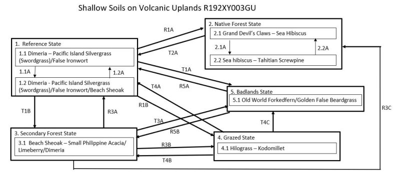
States 1 and 5 (additional transitions)
| R1A | - | The Reference State (1) can be restored to the Native Forest State (2) by fire protection, weed control, erosion control (vetivergrass (Vetiveria sp.) is useful), mulching, fertilizing, and replanting of native plant species. |
|---|---|---|
| T1B | - | The Reference State (1) transitions to the Tree-Invaded State (3) when fire is infrequent, allowing the growth of trees and shrubs. |
| R1B | - | The Reference State (1) can be restored to Grazed State (4) by fire protection, weed control, erosion control, and planting desired forage grass species. |
| T1A | - | The Reference State (1) transitions to the Badlands State (5) through destruction of vegetation cover and surface litter by fire, leading to loss of surface soil horizons by erosion and slumping (Amidon et al., 2019; Amidon et al., 2017; Fosberg, 1960; Stone, 1970; USDA-SCS, 1988; Wagner and Grether, 1948; Willsey et al., 2019). |
| T2A | - | The Native Forest State (2) transitions to the Reference State (1) by destruction of the forest by human-caused fire in adjacent stands of Pacific Island silvergrass or swordgrass. |
| R3A | - | The Tree-Invaded State (3) is restored to the Reference State (1) by fire. |
| R3C | - | The Tree-Invaded State (3) may be restored to the Native Forest State (2). The intensity of active restoration measures will be determined by the presence or lack of native trees already on the site as well as the density and species mix of grasses, vines, shrubs, and introduced trees present on the site, especially if many competitive introduced species are present. |
| R3B | - | The Tree-Invaded State (3) may be restored to the Grazed State (4) by clearing the forest, maintaining erosion control, weed control, and seeding desired forage grasses. |
| T3A | - | The Tree-Invaded State (3) transitions to the Badlands State (5) through destruction of tree cover and surface litter by fire, leading to loss of surface soil horizons by erosion and slumping. Soil slumping is considered rare in forested sites in the Marianas Islands. |
| T4A | - | The Grazed State (4) can transition to the Reference State (1) by reinvasion of weedy species, particularly Pacific Island silvergrass and forbs. |
| T4B | - | The Grazed State (4) can transition to the Tree-Invaded State (3) by abandonment or light grazing that allows establishment of trees and shrubs. |
| T4C | - | The Grazed State (4) can transition to the Badlands State (5) by overgrazing that reduces cover of vegetation and litter to a point at which soil erosion removes the upper soil horizons. |
| R5A | - | The Badlands State (5) can be partially restored to the Reference State (1) by instituting erosion control measures that result in patches of soil accumulation. More information is needed about grasses and other plants that may establish with seeding and mulching on the Cr (weathered rock) horizon. |
| R5B | - | The Badlands State (5) can be restored to the Tree-Invaded State (3) by instituting erosion control measures and excluding fire. Replanting trees, either native, introduced, or both, can then be successful with mulching, fertilization, and addition and maintenance of soil organic matter. |
State 1 submodel, plant communities
| 1.1A | - | Phase 1.1 will change to phase 1.2 over time if fire does not occur over a period that allows scattered trees and shrubs to seed into a site and grow. |
|---|---|---|
| 1.2A | - | Fire kills beach sheoak (Casuarina equisetifolia) and any other woody vegetation that may have established, causing a phase change from 1.2 back to 1.1. |
State 2 submodel, plant communities
| 2.1A | - | Storms that damage or kill trees causes a phase change from 2.1 to 2.2 typified by a partial, temporary change in dominant tree species and a temporary increase in ground level vegetation. |
|---|---|---|
| 2.2A | - | Phase 2.2 will revert to phase 2.1 with gradual regrowth of a more diverse array of native species when given adequate time to recover after disturbance. |