Natural Resources
Conservation Service
Ecological site VX167X01X001
Oxidic Dissected Lowland
Last updated: 5/08/2025
Accessed: 05/19/2025
General information
Provisional. A provisional ecological site description has undergone quality control and quality assurance review. It contains a working state and transition model and enough information to identify the ecological site.
MLRA notes
Major Land Resource Area (MLRA): 167X–Humid Oxidic Soils on Low and Intermediate Rolling Mountain Slopes
This MLRA occurs in the State of Hawaii on the windward, wetter sides of the islands of Kauai, Oahu, and Maui. Elevation ranges from near sea level to 2,000 feet (0 to 610 meters) with extremes up to 3,100 feet (0 to 945 meters). Topography is rolling mountain slopes that have been eroded by steep-sided gulches. In most of the area, volcanic ash is underlaid by basic igneous rocks, although in some areas volcanic ash was deposited over cinders (USDA-NRCS, 2006). In other areas alluvial sediments occur on bottom lands and low terraces along streams. In some small areas, the dominant geology is influenced by tropospheric dust. Average annual precipitation in most of the area ranges from 50 to 114 inches (1,270 to 2,896 millimeters); extremes range from 20 inches to 247 inches (508 to 6,274 millimeters) (Giambelluca et al., 2013). Rainfall is well-distributed throughout the year with an enhanced rainy season from November through April. Average annual air temperatures range from 72 to 77 degrees F (22 to 25 degrees C); extremes range from 61 to 82 degrees F (16 to 28 degrees C) (Giambelluca et al., 2014). The dominant soil orders are Ultisols, Oxisols, Inceptisols, and Andisols with isohyperthermic and isothermic temperature regimes and ustic, udic, and occasionally perudic soil moisture regimes (USDA-NRCS, 2006). Native vegetation consists of medium to tall statured rain forest and open bogs.
Classification relationships
This ecological site occurs within Major Land Resource Area (MLRA) 167 - Humid Oxidic Soils on Low and Intermediate Rolling Mountain Slopes.
The Aha Moku System, which dates back to the 9th century and has been passed down through oral tradition and generational wisdom, effectively sustains Hawaii's natural ecosystems and environment (DLNR, 2024). This site-specific and resource-based approach balances land and ocean resources essential for fostering healthy, thriving communities. Grounded in Native Hawaiian generational knowledge, the Aha Moku System emphasizes community consultation to prioritize the health and welfare of Hawaii's natural and cultural resources. It is rooted in the concept of 'ahupua'a, the traditional system of land and ocean management in Hawaii. For collaboration, this ecological framework encompasses the following mokus:
Moku Acres on Kauai: Puna (23,292), Halele'a (11,322), Kona (7,323), Ko'olau (5,274), and Napali (508).
Moku Acres on Maui: Hamakualoa (14,355), Ko'olau (3,099), and Hamakuapoko (1,452).
Moku Acres on Oahu: Ko'olauloa (24,374), Ko'olaupoko (14,583), Kona (5,157), Waialua (185), Wai'anae (557), and Ewa (11).
Ecological site concept
This ecological site is situated on the north-central coast of East Maui, the northeastern coast of Oahu, and the northern and eastern sides of Kauai. It occurs largely on flat interfluves between numerous gulches, and ranges from 0 to 1,000 feet (0 to 305 meters) with extremes up to 3,100 feet (945 meters) elevation on Maui. Much of the land is in private ownership. The public road network provides access to most of the ecological site. Most of the area is used for crops, livestock grazing, residential development, or is in forests consisting mostly of introduced species (USDI-USGS, 2006).
The central concept of the Oxidic Dissected Lowland is of well drained, deep, and very deep soils formed in highly weathered volcanic materials. Soils are mostly in the Ultisols and Oxisols orders, with low pH, low base saturation, and clay-sized minerals that sequester phosphorus and have pH-dependent ion exchange properties. Annual air temperatures and rainfall are associated with very warm (isohyperthermic to warm isothermic), moist (moist ustic to udic) soil conditions (USDA-SCS, 1972). The most common introduced grass is guineagrass (Urochloa maxima), although para grass or Californiagrass (Urochloa mutica) is abundant in wetter parts of the ecological site. Forested areas contain many introduced species, with strawberry guava (Psidium cattleianum), Java plum (Syzygium javanicum), and African tulip-tree (Spathodea campanulata) among the more common species. White leadtree or koa haole (Leucaena leucocephala) is common in drier extremes, while Brazilian peppertree or christmasberry (Schinus terebinthifolius) is common in areas that define the central concept. Remaining native trees include 'ohi'a lehua (Metrosideros polymorpha) and Tahitian screw pine or hala (Pandanus tectorius), among other (Wagner et al., 1999).
Associated sites
| VX158X01X401 |
Isohyperthermic Ustic Naturalized Grassland Koa haole/guineagrass/glycine (Leucaena leucocephala/Urochloa maxima/Neonotonia wightii) The Isohyperthermic Ustc Naturalized Grassland Ecological Site (R158XY401HI) adjoins this ecological site on Kauai, Oahu, and Maui. It has the same soil temperature regime as this ecological site but a drier soil moisture regime. It is correlated with some highly weathered soils similar to those in this ecological site but, in general, has soils that are less weathered. It supports typical native Hawaiian dry forest to transitional dry-to-moist forest rather than lowland rainforest. Guineagrass rather than para grass is the main forage species in R158XY401HI, while there is para grass in the wetter parts of R167XY001HI. |
|---|---|
| VX158X01X005 |
Naturalized Grassland 50 to 90 inch PZ Ohia lehua/kikuyugrass (Metrosideros polymorpha/Pennisetum clandestinum) The Naturalized Grassland 50 to 90 Inch Precipitation Zone Ecological Site (R158XY005HI) adjoins this ecological site on Kauai and, to very small extents, Oahu and Maui. It has a warmer and drier climate than this ecological site (but cooler and moister than R158XY401HI in the above row) and has similarly highly weathered soils to the soils in this ecological site. Native vegetation is |
| VX167X01X002 |
Flooded Alluvium The Flooded Alluvium Ecological Site (R167XY002HI) adjoins this ecological site on Kauai and Oahu. It occurs on active floodplains along streams that dissect the uplands upon which this ecological site occurs. Climate is identical for these two sites, but R167XY002HI receives additional water during flooding and largely occurs on somewhat poorly to poorly drained soils in contrast with the moderately well and well drained soils of this ecological site. |
| VX164X01X002 |
Organic Surface Forest The Organic Surface Forest Ecological Site (F164XY002HI) adjoins this ecological site on Maui. It receives more rainfall and in part has cooler temperatures than this ecological site. It has well drained soils and supports higher-elevation rainforest than this ecological site, with higher species diversity and wider occurrence of koa trees. |
| VX164X01X004 |
Epiaquic Forest The Epiaquic Forest Ecological Site (F164XY004HI) adjoins this ecological site on Kauai. It occurs mostly at higher elevations with cooler and wetter climate than this ecological site. F164XY004HI has soils with shallow ironstone sheets that cause a perched water table and poorly drained conditions, unlike the moderately well and well drained conditions of this ecological site. It supports stunted rainforest interspersed with open bogs rather than lowland rain forest. |
| VX160X01X007 |
Isothermic Ustic Naturalized Grassland (Kikuyugrass) The Isothermic Ustic Naturalized Grassland Ecological Site (R160XY007HI) adjoins this ecological site on Maui. It occurs at mostly higher elevations with cooler and drier climate and less weathered soils than this ecological site. It would have supported a drier native forest dominated by koa and ohia lehua. The dominant forage species are guineagrass, kikuyugrass, and cool-season grasses rather than para grass. |
Table 1. Dominant plant species
| Tree |
(1) Metrosideros polymorpha |
|---|---|
| Shrub |
Not specified |
| Herbaceous |
(1) Urochloa maxima |
Legacy ID
R167XY001HI
Click on box and path labels to scroll to the respective text.
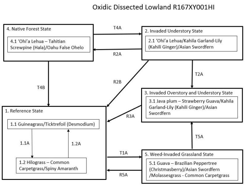
Ecosystem states
States 1 and 5 (additional transitions)
| T1A | - | The Reference State (1) transitions to the Weed Invaded Grassland State (5) by long-term continuous grazing and lack of weed control measures. Remnant desirable forages have been grazed out and replaced entirely by weedy grasses, forbs, shrubs, and small trees. |
|---|---|---|
| R2B | - | The Invaded Understory State (2) can be restored to the Reference State (1) by clearing the forest with heavy machinery and planting desirable forage species. |
| T2A | - | The Invaded Understory State (2) transitions to the Invaded Overstory and Understory State (3) through the process of fast-growing weeds inhibiting reproduction of native plants and gradually replacing them. This process is accelerated by feral pigs and cattle directly damaging native plants and promoting the spread of weeds by disturbing the soil and spreading weed seeds. |
| R2A | - | The Invaded Understory State (2) may be restored to a facsimile of the Native Forest State (4). Construction of a suitable fence and removal of all ungulates are necessary. Intensive weed control must then be initiated and maintained in the long term. In some cases, large amounts of dead weed biomass must be dealt with by removal or decomposition. Reintroduction of missing native species will be necessary. |
| R3A | - | The Invaded Overstory and Understory State (3) can be converted to the Reference State (1) by clearing vegetation using heavy machinery, applying aggressive weed control measures, and planting desirable forage species. |
| T4B | - | The Native Forest State (4) can transition to the Reference State (1) by clearing the forest with heavy machinery and planting desirable pasture species. Native forest may be cleared gradually by allowing cattle access to the forest. Cattle eventually eat or destroy understory ferns, forbs, shrubs, and saplings, opening the forest so that introduced grasses will thrive. |
| T4A | - | The Native Forest State (4) transitions to the Invaded Understory State (2) by the very aggressive, introduced weed species present in this ecological site invading intact native forest and gradually replacing native species in the understory. This invasion is greatly facilitated by feral pigs and cattle that damage and consume native plants, disturb the soil, and spread weed seeds. |
| R5A | - | The Weed Invaded Grassland State (5) can be restored to the Reference State (1) by brush management, re-establishment of desirable forage species, persistent weed control, and prescribed grazing. |
| T5A | - | The Weed Invaded Grassland State (5) transitions to the Invaded Overstory and Understory State (3) due to the presence of fast-growing, introduced tree species; fire may prevent this from occurring. |
State 1 submodel, plant communities
| 1.1A | - | Phase 1.1 changes to phase 1.2 by long-term continuous grazing. Remnant high-quality forages have been greatly reduced in abundance and largely replaced by lower-value species. Weedy forbs and shrubs are increasing. |
|---|---|---|
| 1.2A | - | A grazing plan is needed that provides for intensive but temporary grazing of pastures to ensure that cattle consume some low-value forage species along with preferred forages and to allow preferred forages time to recover from defoliation. Desirable grass species are competitive and able to recover with proper management. The grazing plan may require splitting the herd, creating additional water sources, and creating multiple pastures by cross-fencing. Weed control may be necessary to eliminate some species such as inedible shrubs. |