Natural Resources
Conservation Service
Ecological site VX166X01X001
Isohyperthermic Torric Naturalized Grassland
Last updated: 5/08/2025
Accessed: 05/20/2025
General information
Provisional. A provisional ecological site description has undergone quality control and quality assurance review. It contains a working state and transition model and enough information to identify the ecological site.
MLRA notes
Major Land Resource Area (MLRA): 166X–Very Stony Land and Rock Land
This MLRA occurs in the State of Hawaii on the islands of Maui, Kahoolawe, Lanai, Molokai, Oahu, Kauai, and Niihau. Elevation ranges from sea level to 8,000 feet (0 to 2,440 meters). The terrain encompasses stony complex slopes and rocky gulches (USDA-NRCS, 2006). The geology is extrusive basic igneous rock (primarily basalt) that are weathered in some areas. Some interfluves are mantled with weathered volcanic ash. Average annual precipitation ranges from 17 to 39 inches (430 to 990 millimeters) (Giambelluca et al., 2013). Extreme average annual precipitation ranges from 10 to 107 inches (254 to 2,720 millimeters). Most of the rainfall occurs from November through March, much of it during kona storms. Average annual air temperatures ranges from 70 to 75 degrees F (21 to 24 degrees C) with little seasonal variation (Giambelluca et al., 2014). Extreme annual air temperatures range from 48 to 82 degrees F (9 to 28 degrees C). Dominant soils are Mollisols, Aridisols, and Entisols with an isohyperthermic, isothermic, or isomesic soil temperature regimes and ustic or aridic soil moisture regimes (USDA-NRCS, 2006). Vegetation consists of forbs, grasses, and shrubs with some trees. Most of the plant species typically encountered are introduced species that have become naturalized in Hawaii. However, areas within this MLRA are critical habitat for rare, threatened, or endangered plant species.
Classification relationships
This ecological site occurs within Major Land Resource Area (MLRA) 166 - Very Stony Land and Rock Land.
The Aha Moku System, which dates back to the 9th century and has been passed down through oral tradition and generational wisdom, effectively sustains Hawaii's natural ecosystems and environment (DLNR, 2024). This site-specific and resource-based approach balances land and ocean resources essential for fostering healthy, thriving communities. Grounded in Native Hawaiian generational knowledge, the Aha Moku System emphasizes community consultation to prioritize the health and welfare of Hawaii’s natural and cultural resources. It is rooted in the concept of 'ahupua'a, the traditional system of land and ocean management in Hawaii. For collaboration, this ecological framework encompasses the following mokus:
Moku Acres on Molokai: Kona (2,196).
Moku Acres on Oahu: Ko'olaupoko (1,561).
Moku Acres on Lanai: Lahaina (412).
Ecological site concept
This ecological site is largely naturalized grassland and savanna on the northeastern shore of Lanai, the leeward shores of Molokai, and the extreme eastern tip of Oahu. Most of the area is owned by the City and County of Honolulu, large private ranches and land companies, Division of Hawaiian Homelands, and small private holdings. Access is limited but may be possible on the coastal road at the eastern tip of Oahu.
The central concept of the Isohyperthermic Torric Naturalized Grassland Ecological Site is of well drained, deep, Andisols and Entisols (fluvents) formed in deposits of volcanic ash, cinders and tuff or alluvium derived from those materials or alluvium derived from general volcanic materials. Annual air temperatures and rainfall are associated with very warm (isohyperthermic), usually dry (torric) soil conditions (USDA-SCS, 1972). Elevations range from sea level (0 meters) to about 200 feet (61 meters), with extreme examples up to 400 feet (122 meters). Because very little of the original native vegetation remains, the Reference State of this ecological site consists of the dominant, naturalized grassland vegetation. The dominant grass species is buffelgrass (Pennisetum ciliare). Common naturalized trees are kiawe (Prosopis pallida) and white leadtree or koa haole (Leucaena leucocephala).
The original native vegetation was dry coastal savanna (Egler, 1947; Wagner et al., 1999). Some common species, based on the current environment and remnant occurrences, were wili wili (Erythrina sandwicensis), naio (Myoporum sandwicense), Florida hopbush or a’alii (Dodonaea viscosa), yellow ‘ilima (Sida fallax), sandmat (Chamaesyce spp.), and native grasses.
Associated sites
| VX158X01X002 |
Isohyperthermic Torric Naturalized Grassland Kiawe/buffelgrass (Prosopis pallida/Pennisetum ciliare) Some boundaries of the Isohyperthermic Torric Naturalized Grassland Ecological Site (R158XY002HI) near the coast adjoin this ecological site. R158XY002HI occurs overwhelmingly in uplands but the soils with which it is correlated reach the coast in many areas. It differs by having soils which are mostly Mollisols rather than the Andisols and Entisols (fluvents) which occur in this ecological site. The two ecological sites support similar vegetation in these coastal areas. |
|---|
Table 1. Dominant plant species
| Tree |
(1) Prosopis pallida |
|---|---|
| Shrub |
Not specified |
| Herbaceous |
(1) Pennisetum ciliare |
Legacy ID
R166XY001HI
Click on box and path labels to scroll to the respective text.
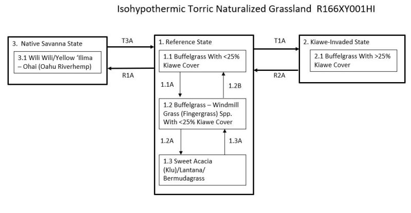
Ecosystem states
| T1A | - | The Reference State (1) transitions to the Kiawe-Invaded State (2) with lack of brush management practices or absence of wildfire. |
|---|---|---|
| R1A | - | The Reference State (1) can be restored to a facsimile of the Native Savanna State (3). Domestic and feral ungulates and fire must be excluded from the site. Buffelgrass and other non-native vegetation must be eliminated, followed by plantings of native trees, shrubs, grasses, forbs, and vines. Supplemental irrigation may be necessary in the early stages of restoration. |
| R2A | - | The Kiawe-Invaded State (2) can be restored to the Reference State (1) by applying brush management. Fire will kill kiawe; prescribed burning is typically not done in Hawaii due to the level of risk. |
| T3A | - | The Native Savanna State (3) transitions to the Reference State (1) when cleared by fire, long-term ungulate disturbance, or mechanical means. Desired forage species are then re-established. |
State 1 submodel, plant communities
| 1.1A | - | Buffelgrass cover and vigor are reduced by continuous grazing, causing it to decrease and be partially replaced by less desirable forages. |
|---|---|---|
| 1.2B | - | Phase 1.2 can change to phase 1.1 by application of a prescribed grazing program that allows buffelgrass to reassume dominance. Weed control may be necessary if taller weedy forbs and/or shrubs are abundant. |
| 1.2A | - | Community phase 1.2 changes to phase 1.3 with long-term and/or heavy continuous grazing. Species composition changes to dominance by shortgrasses, weedy forbs, and shrubs. Bare ground increases markedly. |
| 1.3A | - | Phase 1.3 can change to phase 1.2 by application of a prescribed grazing program that allows buffelgrass to reassume dominance. Herbicidal weed control may be necessary. |