Natural Resources
Conservation Service
Ecological site VX163X01X005
Aquic Coastal Wetland
Last updated: 5/08/2025
Accessed: 05/19/2025
General information
Provisional. A provisional ecological site description has undergone quality control and quality assurance review. It contains a working state and transition model and enough information to identify the ecological site.
MLRA notes
Major Land Resource Area (MLRA): 163X–Alluvial Fans and Coastal Plains
This MLRA is in the State of Hawaii on the islands of Maui, Lanai, Molokai, Oahu, and Kauai. Elevation ranges from sea level to 800 feet (0 to 244 meters) with elevation extremes up to 1,600 feet (488 meters). The terrain is nearly level and gently sloping coastal plains and adjacent alluvial fans. Beneath the unconsolidated sediments are basalt, coral limestone, calcareous sand deposits, volcanic ash, coral sand, and fill. Average annual precipitation ranges from 10 to 40 inches (254 to 1,016 millimeters) with precipitation extremes up to 122 inches (3,099 millimeters) in select places on Oahu and Kauai (Giambelluca et al., 2013). Most of the rainfall occurs from November through March during kona storms that come in from the leeward side of the islands. Average annual temperatures range from 68 to 82 degrees F (20 to 28 degrees C) with little seasonal variation (Giambelluca et al., 2014). Dominant soils are Mollisols, Aridisols, Entisols, and Vertisols with an isohyperthermic soil temperature regime and aquic or aridic (torric) to ustic soil moisture regimes. Vegetation consists of forbs, grasses, and shrubs with some trees. Almost all the plant species typically encountered are introduced species that have become naturalized in Hawaii (USDA-NRCS, 2006).
Classification relationships
This ecological site occurs within Major Land Resource Area (MLRA) 163 - Alluvial Fans and Coastal Plains.
The Aha Moku System, which dates back to the 9th century and has been passed down through oral tradition and generational wisdom, effectively sustains Hawaii's natural ecosystems and environment (DLNR, 2024). This site-specific and resource-based approach balances land and ocean resources essential for fostering healthy, thriving communities. Grounded in Native Hawaiian generational knowledge, the Aha Moku System emphasizes community consultation to prioritize the health and welfare of Hawaii’s natural and cultural resources. It is rooted in the concept of 'ahupua'a, the traditional system of land and ocean management in Hawaii. For collaboration, this ecological framework encompasses the following mokus:
Kauai Moku Acres: Kona (2,110), Puna (590), Halele'a (477), and Ko'olau (97).
Oahu Moku Acres: Ko'olauloa (1,331), 'Ewa (928), Ko'olaupoko (569), Kona (488), Waialua (288), and O'ahu (73).
Ecological site concept
This ecological site occurs on coastal plains in scattered locations around the coastlines of Kauai and Oahu, where it is accessible from state highways. Many of the former wetlands have been drained and are used for homesites, urban development, pasture, or crops (USDI-USGS, 2006). This is particularly the case for Kaloko clay and Nohili clay on Kauai.
The central concept of the Aquic Coastal Wetland is of low elevation sites near the ocean that have poorly, and very poorly drained soils formed in alluvium deposited over calcareous material or, in some cases, muck. Soils are wet due to subsurface water that rises near or to the soil surface; some sites may be ponded or flooded occasionally. Water is fresh where streams or fresh groundwater approach the ocean and brackish where freshwater mixes with salt water. Vegetation is a mix of woody species, forbs, and especially sedges, rushes, and grasses (USDA-SCS, 1972). Many species inhabit a spectrum of salinity along the gradient.
Associated sites
| VX158X01X401 |
Isohyperthermic Ustic Naturalized Grassland Koa haole/guineagrass/glycine (Leucaena leucocephala/Urochloa maxima/Neonotonia wightii) The Isohyperthermic Ustic Naturalized Grassland Ecological Site has a similarly warm but slightly moister climate compared with this ecological site, but it has well drained soils that support rangeland vegetation or dry forest rather than wetlands. |
|---|---|
| VX163X01X002 |
Sandy Shrubland The Sandy Shrubland Ecological Site has a similar cliimate to this ecological site, but it has sandy, excessively drained soils that support dry rangeland vegetation rather than wetlands. |
| VX163X01X004 |
South and West Aspect Isohyperthermic Naturalized Grassland The South and West Aspect Isohyperthermic Naturalized Grassland Ecological Site has a similar climate to this ecological site, but it has well drained soils that support dry rangeland vegetation rather than wetlands. |
Table 1. Dominant plant species
| Tree |
(1) Hibiscus tiliaceus |
|---|---|
| Shrub |
Not specified |
| Herbaceous |
(1) Bacopa monnieri |
Legacy ID
R163XY005HI
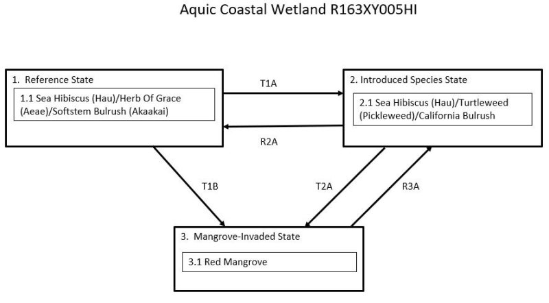
Click on box and path labels to scroll to the respective text.
| T1A | - | The Reference State (1) transitions to the Introduced Species State (2) by gradual invasion and replacement of native species by introduced plant species. |
|---|---|---|
| T1B | - | The Reference State (1) transitions to the Mangrove-Invaded State (3) by gradual invasion and replacement of native and introduced herbaceous species by mangroves. |
| R2A | - | It may not be feasible to restore the Introduced Species State (2) to the Reference State (1) due to the intermixing of introduced and native species and the unknown provenance of some species. It is worthwhile in some cases to reduce the abundance of weedy species and reintroduce native plant species where the wildlife habitat functions of the marsh have been degraded. |
| T2A | - | The Introduced Species State (2) transitions to the Mangrove-Invaded State (3) by gradual invasion and replacement of herbaceous stands by woody mangroves. |
| R3A | - | Mechanical or hand methods can be employed to remove mangroves and reestablish herbaceous vegetation. |