
Natural Resources
Conservation Service
Ecological site VX163X01X003
East Aspect Isohyperthermic Naturalized Grassland
Last updated: 5/08/2025
Accessed: 05/19/2025
General information
Provisional. A provisional ecological site description has undergone quality control and quality assurance review. It contains a working state and transition model and enough information to identify the ecological site.
MLRA notes
Major Land Resource Area (MLRA): 163X–Alluvial Fans and Coastal Plains
This MLRA is in the State of Hawaii on the islands of Maui, Lanai, Molokai, Oahu, and Kauai. Elevation ranges from sea level to 800 feet (0 to 244 meters) with elevation extremes up to 1,600 feet (488 meters). The terrain is nearly level and gently sloping coastal plains and adjacent alluvial fans. Beneath the unconsolidated sediments are basalt, coral limestone, calcareous sand deposits, volcanic ash, coral sand, and fill. Average annual precipitation ranges from 10 to 40 inches (254 to 1,016 millimeters) with precipitation extremes up to 122 inches (3,099 millimeters) in select places on Oahu and Kauai (Giambelluca et al., 2013). Most of the rainfall occurs from November through March during kona storms that come in from the leeward side of the islands. Average annual temperatures range from 68 to 82 degrees F (20 to 28 degrees C) with little seasonal variation (Giambelluca et al., 2014). Dominant soils are Mollisols, Aridisols, Entisols, and Vertisols with an isohyperthermic soil temperature regime and aquic or aridic (torric) to ustic soil moisture regimes. Vegetation consists of forbs, grasses, and shrubs with some trees. Almost all the plant species typically encountered are introduced species that have become naturalized in Hawaii.
Classification relationships
This ecological site occurs within Major Land Resource Area (MLRA) 163 - Alluvial Fans and Coastal Plains.
The Aha Moku System, which dates back to the 9th century and has been passed down through oral tradition and generational wisdom, effectively sustains Hawaii's natural ecosystems and environment (DLNR, 2024). This site-specific and resource-based approach balances land and ocean resources essential for fostering healthy, thriving communities. Grounded in Native Hawaiian generational knowledge, the Aha Moku System emphasizes community consultation to prioritize the health and welfare of Hawaii's natural and cultural resources. It is rooted in the concept of 'ahupua'a, the traditional system of land and ocean management in Hawaii. For collaboration, this ecological framework encompasses the following mokus:
Maui Moku Acres: Pu’ali Komohana (5,500), Hamakuapoko (501), Kula (12), and Hamakualoa (7).
Ecological site concept
This ecological site is largely naturalized grassland at low elevations on the eastern slope of the West Maui Mountains. Scattered outliers occur on the lower slopes of Haleakala below the towns of Pukalani and Makawao. Much of the area is, or has been, in intensive agriculture or has been developed (USDI-USGS, 2006). Principal landowners are large private land companies, ranches, and the State of Hawaii. It is accessible along Routes 30 and 330 from Waihee to Waikapu.
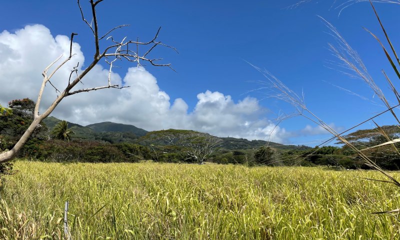
The central concept of the East Aspect Isohyperthermic Naturalized Grassland is of well drained, very deep soils with mollic (high organic matter and base saturation) properties that formed in alluvium from basic igneous rock. Annual air temperatures and rainfall are associated with very warm (isohyperthermic), seasonally dry (ustic) soil conditions (USDA-SCS, 1972). The east-facing aspect shields the site from the sun during the hottest parts of the day. Elevations range from sea level (0 meters) to about 1,000 feet (305 meters) with extremes up to 1,500 feet (457 meters). Because very little of the original native vegetation remains, the reference state of this ecological site consists of the dominant naturalized grassland vegetation. The dominant grass species is guineagrass (Urochloa maxima). Common naturalized trees are white leadtree or koa haole (Leucaena leucocephala) and Brazilian peppertree or christmasberry (Schinus terebinthifolius).
The original native vegetation was dry forest (Rock, 1913; Wagner et al., 1999). Common species, based on the current environment and remnant occurrences, were lama (Diospyros sandwicensis), alahe’e (Psydrax odorata), ohe makai (Reynoldsia sandwicensis), wili wili (Erythrina sandwicensis), naio (Myoporum sandwicense), koaohe or koaia (Acacia koaia), Florida hopbush or aalii (Dodonaea viscosa), Hawai’i hawthorn or ulei (Osteomeles anthyllidifolia), queen coralbead or huehue (Cocculus orbiculatus), and native grasses.
Associated sites
| VX158X01X002 |
Isohyperthermic Torric Naturalized Grassland Kiawe/buffelgrass (Prosopis pallida/Pennisetum ciliare) The Isohyperthermic Torric Naturalized Grassland Ecological Site has a warmer and drier climate than this ecological site and does not have the protection of an east-facing aspect, making it even warmer and drier. It supports plant species adapted to a drier environment. |
|---|---|
| VX163X01X002 |
Sandy Shrubland The Sandy Shrubland Ecological Site has a warmer and drier climate than this ecological site and does not have the protection of an east-facing aspect, making it even warmer and drier. It also has sandy soils with much less water-holding capacity than this ecological site and supports plant species adapted to a much drier environment. |
Similar sites
| VX163X01X004 |
South and West Aspect Isohyperthermic Naturalized Grassland The South and West Aspect Isohyperthermic Naturalized Grassland has a similar climate to this ecological site but does not have the protection of an east-facing aspect, making it warmer and drier. It supports plant species adapted to a drier environment. |
|---|
Table 1. Dominant plant species
| Tree |
(1) Leucaena leucocephala |
|---|---|
| Shrub |
Not specified |
| Herbaceous |
(1) Urochloa maxima |
Legacy ID
R163XY003HI
Click on box and path labels to scroll to the respective text.
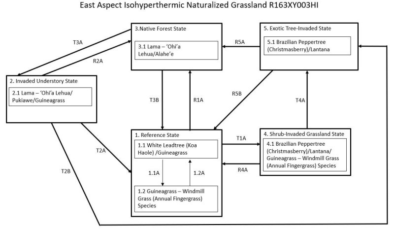
Ecosystem states
States 1, 5 and 2 (additional transitions)
| R1A | - | It is possible to restore the Reference State (1) to a plant community resembling the Native Forest State (3). Weed control must be applied to forage species and the many opportunistic plant species that would invade the site. Weed control would be a perpetual process to maintain the site. Fire must be excluded. Domestic and feral ungulates must be excluded by a suitably designed and maintained fence. Extensive planting of native species would follow. |
|---|---|---|
| T1A | - | The Reference State (1) transitions to the Shrub Invaded Grassland State (4) through further overgrazing or abandonment. Fire will temporarily prevent this transition. White leadtree (koa haole) will be greatly reduced by over browsing. If the site contained abundant koa haole and was then abandoned, these small trees overtop guineagrass and greatly increase in abundance. Otherwise, there is gradual invasion by weedy shrubs and small trees. |
| T2A | - | The Invaded Understory State (2) transitions to the Reference State (1) by land clearing with heavy machinery followed by weed control. Land clearing can promote germination of the weed seed bank in the soil, requiring intensive weed control. After clearing and weed control, the site would be planted to forage species. |
| R2A | - | The Invaded Understory State (2) may be restored to the Native Forest State (3), or to a facsimile of the Reference State, by removal of the introduced understory through weed control. Reintroduction of native understory species is required. The site must be fenced securely to exclude ungulates. |
| T2B | - | The Invaded Understory State (2) transitions the Exotic Tree Invaded State (5) by growth of introduced tree species through and above the native canopy. Lack of reproduction leads to gradual loss of most native plants. |
| T3B | - | The Native Forest State (3) transitions to the Reference State (1) by clearing the forest and planting desirable forage species. |
| T3A | - | The Native Forest State (3) transitions to the Invaded Understory State (2) through grazing, browsing, rooting, and trampling by domestic or feral ungulates (cows, sheep, deer, goats, and pigs). These activities destroy small native plant species and seedlings and saplings of large species. Regeneration of the native forest is prevented, leading to tree populations consisting almost entirely of mature plants. Lack of competition from native plants, introduction of weed seeds, and disturbance of the soil lead to an understory dominated by introduced plant species. Weeds can invade intact native forest even in the absence of ungulates and gradually bring about the transition. Invasive vines, shrubs, and small trees will grow under intact native canopies and begin to degrade the forest. Eventually, introduced grasses provide fine fuels that can carry intense fires that destroy the native tree canopy. |
| R4A | - | The Shrub-Invaded Grassland State (4) can be restored to the Reference State (1) by brush management with follow-up control of resprouting shrubs and emerging weedy forbs. Forage species may then be replanted and maintained by prescribed grazing. |
| T4A | - | The Shrub-Invaded Grassland State (4) transitions to the Exotic Tree Invaded State (5) with lack of fire. Fast-growing introduced tree species invade Shrub Invaded Grassland and overtop shrubs, or Brazilian peppertree (christmasberry) increases in stature and density to become dominant. |
| R5B | - | The Exotic Tree-Invaded State (5) may be restored to the Reference State (1). Total clearing of the site would be necessary. If clearing is done by heavy machinery, soil disturbance would occur. This would probably induce germination of the weed seed bank and increase the potential for soil erosion. Weed control and brush management must then be applied multiple times to control new weed germination and resprouting. After clearing and weed control, the site would be planted to forage species. Ungulates must be excluded until forages are well established; prescribed grazing must then be applied. |
| R5A | - | It may be possible to restore the Exotic Tree-Invaded State (5) to a community resembling the Native Fores State (3). Total clearing of the site would be necessary. Alternatively, it may be worthwhile to kill taller weed species in place by herbicide applications in order to provide some shelter for the ground. If clearing is done by heavy machinery, soil disturbance would occur. This could induce germination of the weed seed bank and also increase the potential for soil erosion. Weed control would be ongoing. Protection from fire is needed, and ungulates must be excluded by a suitable fence. |
State 1 submodel, plant communities
| 1.1A | - | Community phase 1.1 converts to phase 1.2 by continuous grazing without adequate rest for preferred forages. This conversion can be avoided by timely application of deferred or prescribed grazing to control guineagrass stature and allow recovery of desirable species after grazing or browsing. |
|---|---|---|
| 1.2A | - | Community phase 1.2 can be converted to phase 1.1 by removing undesirable species and favoring and establishing desirable pasture species. Because guineagrass is still fairly abundant, prescribed grazing may eventually affect the conversion. Pitted beardgrass (Bothriochloa pertusa) and rose Natal grass (Melinis repens) have some value as forage. However, annual fingergrasses, barbwire grass, Colombian bluestem, broomsedge bluestem are unpalatable to livestock and difficult to control by grazing. If pasture condition is very poor, active weed control measures followed by reestablishment of guineagrass will be necessary. |