Natural Resources
Conservation Service
Ecological site VX163X01X001
Shrink-Swell Clay
Last updated: 5/08/2025
Accessed: 05/19/2025
General information
Provisional. A provisional ecological site description has undergone quality control and quality assurance review. It contains a working state and transition model and enough information to identify the ecological site.
MLRA notes
Major Land Resource Area (MLRA): 163X–Alluvial Fans and Coastal Plains
This MLRA is in the State of Hawaii on the islands of Maui, Lanai, Molokai, Oahu, and Kauai. Elevation ranges from sea level to 800 feet (0 to 244 meters) with elevation extremes up to 1,600 feet (488 meters). The terrain is nearly level and gently sloping coastal plains and adjacent alluvial fans. Beneath the unconsolidated sediments are basalt, coral limestone, calcareous sand deposits, volcanic ash, coral sand, and fill. Average annual precipitation ranges from 10 to 40 inches (254 to 1,016 millimeters) with precipitation extremes up to 122 inches (3,099 millimeters) in select places on Oahu and Kauai (Giambelluca et al., 2013). Most of the rainfall occurs from November through March during kona storms that come in from the leeward side of the islands. Average annual temperatures range from 68 to 82 degrees F (20 to 28 degrees C) with little seasonal variation (Giambelluca et al., 2014). Dominant soils are Mollisols, Aridisols, Entisols, and Vertisols with an isohyperthermic soil temperature regime and aquic or aridic (torric) to ustic soil moisture regimes. Vegetation consists of forbs, grasses, and shrubs with some trees. Almost all the plant species typically encountered are introduced species that have become naturalized in Hawaii (USDA-NRCS, 2006).
Classification relationships
This ecological site occurs within Major Land Resource Area (MLRA) 163 - Alluvial Fans and Coastal Plains.
The Aha Moku System, which dates back to the 9th century and has been passed down through oral tradition and generational wisdom, effectively sustains Hawaii's natural ecosystems and environment (DLNR, 2024). This site-specific and resource-based approach balances land and ocean resources essential for fostering healthy, thriving communities. Grounded in Native Hawaiian generational knowledge, the Aha Moku System emphasizes community consultation to prioritize the health and welfare of Hawaii’s natural and cultural resources. It is rooted in the concept of 'ahupua'a, the traditional system of land and ocean management in Hawaii. For collaboration, this ecological framework encompasses the following mokus:
Oahu Moku Acres: Wai’anae (7,982), Kona (5,468), Ewa (5,420), Ko’olaupoko (1,677), Ko’olauloa (881), and Waialua (677).
Kauai Moku Acres: Kona (2,490), Ko’olau (99), and Napali (42).
Molokai Moku Aces: Kona (1,497).
Lanai Moku Acres: Lahaina (67).
Ecological site concept
This ecological site is largely cropland or naturalized grassland at low elevations on the leeward slopes of Molokai, Lanai, Oahu, and Kauai. Much of the area is in cropland, grazing land, or has been developed (USDI-USGS, 2006). Principal landowners are the United States Government, the State of Hawaii, and private land companies and ranches. It can be accessed along Kaunakakai Road on the southwestern coast of Molokai, on the eastern coast of Lanai along the local road near Lopa, near Route 93 near Waianae on Oahu, and along Route 50 Kekaha on Kauai.
The central concept of the Shrink-Swell Clay Ecological Site is of clayey soils formed in alluvium, volcanic tuff, or residuum from basic igneous rock. The soils are in the Soil Order of Vertisols. Annual air temperatures and rainfall are associated with very warm (isohyperthermic), seasonally dry (aridic/torric or aridic/ustic intergrade) soil conditions. Elevations range from sea level to 800 feet (0 to 244 meters) with elevation extremes up to 1,600 feet (488 meters) (USDA-SCS, 1972). Because very little of the original native vegetation remains, the reference state of this ecological site consists of naturalized grassland vegetation. The dominant introduced grass species is buffelgrass (Pennisetum ciliare). Common naturalized trees are kiawe (Prosopis pallida) and white leadtree or haole (Leucaena leucocephala).
The original native vegetation was probably dry savanna or shrubland with grasses. Common native species, based largely on conjecture until field work can be done, may have been 'ohe makai (Reynoldsia sandwicensis), wili wili (Erythrina sandwicensis), lama (Diospyros sandwicensis), naio (Myoporum sandwicense), Florida hopbush or aalii (Dodonaea viscosa), yellow ‘ilima (Sida fallax), oval-leaf clustervine or pauohiiaka (Jacquemontia ovalifolia ssp. sandwicensis), queen coralbead or huehue (Cocculus orbiculatus), and native grasses (Rock, 1913; Wagner et al., 1999).
Associated sites
| VX158X01X002 |
Isohyperthermic Torric Naturalized Grassland Kiawe/buffelgrass (Prosopis pallida/Pennisetum ciliare) The Isohyperthermic Torric Naturalized Grassland Ecological Site has a similar climate to this ecological site, but its soils are very different. It does not have shrink-swell clays (Vertisols) and generally has less water-holding capacity. The plant species of these ecological sites are similar. |
|---|---|
| VX158X01X401 |
Isohyperthermic Ustic Naturalized Grassland Koa haole/guineagrass/glycine (Leucaena leucocephala/Urochloa maxima/Neonotonia wightii) The Isohyperthermic Ustic Naturalized Grassland Ecological Site has a moister and slightly cooler climate than this ecological site and its soils are very different. It does not have shrink-swell clays (Vertisols). The plant species of Shrink-Swell Clay are similar to those found in the lowest elevations of the Isohyperthermic Ustic Naturalized Grassland. |
| VX163X01X004 |
South and West Aspect Isohyperthermic Naturalized Grassland The South and West Aspect Isohyperthermic Naturalized Grassland Ecological Site has a similar climate and aspect to this ecological site. It does not have shrink-swell clays (Vertisols) and generally less water-holding capacity. The plant species of these ecological sites are similar. |
Table 1. Dominant plant species
| Tree |
(1) Prosopis pallida |
|---|---|
| Shrub |
Not specified |
| Herbaceous |
(1) Pennisetum ciliare |
Legacy ID
R163XY001HI
Click on box and path labels to scroll to the respective text.
Ecosystem states
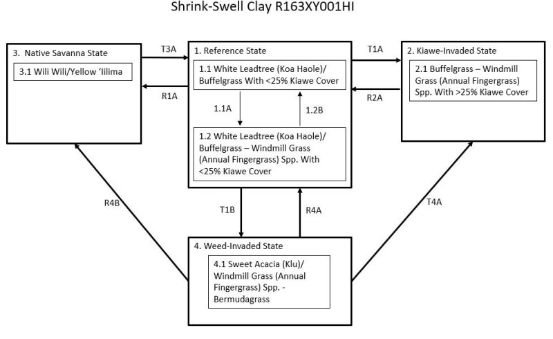
| T1A | - | Reference State (1) transitions to Kiawe-Invaded State (2) with lack of disturbance (brush management practices or absence of fire). |
|---|---|---|
| R1A | - | Reference State (1) can be restored to a facsimile of Native Savanna State (3). The site must be fenced to exclude all domestic and feral ungulates. Perimeter protection from fire must be created and maintained around the fence line. Non-native vegetation must be removed, followed by plantings of native trees, shrubs, and vines. Supplemental irrigation may be necessary in the early stages of restoration. |
| T1B | - | Reference State (1) transitions to Weed-Invaded State (4) with long-term and heavy continuous grazing. Species composition changes to dominance by shortgrasses, weedy forbs, and shrubs. Bare ground increases markedly. |
| R2A | - | Kiawe-Invaded State (2) can be restored to Reference State (1) by applying brush management. Fire will kill kiawe, but there may not be enough understory fuels to carry an intense fire. |
| T3A | - | Native Forest State (3) transitions to Reference State (1) when cleared by fire, long-term ungulate disturbance, or mechanical means. Desired forage species are then established. |
| R4A | - | Weed Invaded State (4) can be restored to Reference State (1) by application of a prescribed grazing program that allows buffelgrass to reassume dominance. Weed control and brush management are likely to be necessary. |
| T4A | - | Weed Invaded State (4) transitions to Kiawe-Invaded State (2) with lack of brush management practices or absence of fire along with a nearby source of kiawe seeds. |
| R4B | - | Weed Invaded State (4) can be restored to a facsimile of Native Savanna State (3). The site must be fenced to exclude all domestic and feral ungulates. Perimeter protection from fire must be created and maintained around the fence line. Non-native vegetation must be removed, followed by plantings of native trees, shrubs, and vines. Supplemental irrigation may be necessary in the early stages of restoration. |
State 1 submodel, plant communities
| 1.1A | - | Buffelgrass and koa haole cover and vigor are reduced by continuous grazing, causing it to decrease and be partially replaced by less desirable forages. |
|---|---|---|
| 1.2B | - | Phase 1.2 can change to phase 1.1 by application of a prescribed grazing program that allows buffelgrass to reassume dominance and heavily browsed white leadtree (koa haole) trees to regrow. Weed control may be necessary if taller weedy forbs or shrubs or both are abundant. |