Natural Resources
Conservation Service
Ecological site VX157X01X001
Torric Naturalized Grassland
Last updated: 5/08/2025
Accessed: 05/19/2025
General information
Provisional. A provisional ecological site description has undergone quality control and quality assurance review. It contains a working state and transition model and enough information to identify the ecological site.
MLRA notes
Major Land Resource Area (MLRA): 157X–Arid and Semiarid Low Mountain Slopes
4/25/2011 Began editing in ESIS- Megan Baxter
Classification relationships
The Hawaii Agricultural Experiment Station Bulletin 89 (1942) described this area, that includes this rangeland ecological site, as Vegetation Zone A. The Soil Survey of the Island of Hawaii (1973) and the Soil Survey of the Islands of Kauai, Oahu, Molokai, and Lanai (1972) had pasture groups developed to describe rangeland. Pasture Group 1 is very similar to the this rangeland ecological site. In some instances, Pasture Group 2 is very close in nature to this site as well.
Associated sites
| VX157X01X003 |
Rocky Volcanic Ash Savanna Kiawe/buffelgrass (Prosopis pallida/Pennisetum ciliare) |
|---|---|
| VX157X01X004 |
Alluvial Woodland (Kiawe/Prosopis pallida) |
Table 1. Dominant plant species
| Tree |
Not specified |
|---|---|
| Shrub |
Not specified |
| Herbaceous |
(1) Pennisetum ciliare |
Legacy ID
R157XY001HI
Physiographic features
This site occurs on nearly level to gently rolling coastal plains to sometimes moderately steep low mountain slopes. This site, as well as the major land resource area, can be classified as desert.
Table 2. Representative physiographic features
| Landforms |
(1)
Lava flow
(2) Shield volcano (3) Kipuka |
|---|---|
| Flooding frequency | None |
| Ponding frequency | None |
| Elevation | 1,000 ft |
| Slope | 1 – 15% |
| Ponding depth |
Not specified |
| Water table depth |
Not specified |
| Aspect | S, SW, W |
Climatic features
Average annual precipitation throughout the entire major land resource area ranges from 5 to 25 inches. Most of the precipitation falls from November to May; with January being the wettest month. Average annual temperatures range from 66 to 88 degrees F. The climate is aridic.
Table 3. Representative climatic features
| Frost-free period (average) | 365 days |
|---|---|
| Freeze-free period (average) | 365 days |
| Precipitation total (average) | 25 in |
Figure 1. Monthly average minimum and maximum temperature
Influencing water features
There are no water features that influence this site.
Soil features
Typical soils are moderately deep to deep, with some inclusions of very deep, and are well drained to somewhat excessively drained. These soils formed in volcanic as and from materials weathered from basalt. Surface textures range from very fine sandy loam to silty clay loams and silty clays. Surface texture may be cobbly, stony or very stony. Underlying soil textures vary from moderately-coarse (or coarse-loamy) to moderately-fine textured (or fine-loamy). Underlying layers may also be cobbly or stony. Available water capacity is moderate to high. Permeability is moderate to moderately rapid. Runoff ranges from low to medium. Soil colors range from reddish brown and dark brown to yellowish brown. Soil reactions (pH) generally range from neutral to mildly alkaline. The erosion hazard is moderate. Soil temperature regimee is isohyperthermic. Soil moisture regimes may vary from dry ustic to aridic.
MU Symbols & components, HI701 & HI801 Soil Survey Areas (2011):
502 - Kaalualu
503 - Kaalualu
504 - Kaalualu
505 - Kaalualu
506 - Pakini
507 - Pakini
510 - Kaalualu and Pakini
535 - Lithic Haplotorrands
743 - Pakini
Table 4. Representative soil features
| Parent material |
(1)
Basic volcanic ash
–
volcanic breccia
|
|---|---|
| Surface texture |
(1) Cobbly loamy sand (2) Medial loam (3) Very cobbly silt loam |
| Family particle size |
(1) Loamy |
| Drainage class | Well drained to somewhat excessively drained |
| Permeability class | Very slow to moderately slow |
| Soil depth | 20 – 72 in |
| Surface fragment cover <=3" | 1 – 10% |
| Surface fragment cover >3" | 1 – 15% |
| Available water capacity (0-40in) |
2 – 5 in |
| Calcium carbonate equivalent (0-40in) |
5% |
| Electrical conductivity (0-40in) |
2 mmhos/cm |
| Sodium adsorption ratio (0-40in) |
Not specified |
| Soil reaction (1:1 water) (0-40in) |
6.6 – 7.8 |
| Subsurface fragment volume <=3" (Depth not specified) |
1 – 10% |
| Subsurface fragment volume >3" (Depth not specified) |
15 – 80% |
Ecological dynamics
Throughout most of its location, this site occurs as an open grassland. With continuous grazing, particularly by cattle, palatable perennial grasses such as buffelgrass, green panic, and piligrass decrease. Koa haole (ekoa) will also decrease under heavy grazing pressure.
Pitted beardgrass is the primary increaser under such circumstances with lesser amounts of swollen fingergrass.
With severe deterioration, shrubby species can increase to dominate such as lantana and sweet acacia. Weedy annual and perennial forbs such lion’s ear mint, golden crownbeard and fireweed will invade this site. Warm season rhizomatous grasses such as bermudagrass and crabgrass also invade the site with severe deterioration.
Kiawe tends to be tall and scattered, reaching almost tree-like stature in most instances when it is present.
Natural fire may be important to the development of this naturalized plant community. Some plant species associated with this site developed in other parts of the world where natural fire is part of the ecosystem. In areas where low shrubs and half-shrubs dominate, the potential production of perennial grass can be greater than the present production of low shrubs and half-shrubs once they are removed from the plant community by fire or brush management.
This site has a history of destructive wildfires as many areas have a high understory fine fuel build-up due to the exclusion of livestock grazing. Because this site can border the ocean, the grass should be managed to control the movement of sediment from water erosion to meet current and future objectives of coastal zone management.
Following are the narratives for each of the described plant communities. These plant communities may not represent every possibility, but at this time they are the most prevalent and repeatable plant communities expressed on this ecological site. The plant composition table shown above has been developed from the best available knowledge at the time of this revision. As more data are collected, some of these plant communities may be revised or removed, and new ones may be added. None of these plant communities should necessarily be thought of as “Desired Plant Communities”. According to the USDA NRCS National Range and Pasture Handbook, Desired Plant Communities will be determined by the decision-makers and will meet minimum resource quality criteria established by the NRCS. The main purpose for including any description of a plant community here is to capture the current knowledge, observation and experience at the time of this revision.
State and transition model
More interactive model formats are also available.
View Interactive Models
Click on state and transition labels to scroll to the respective text
State 1 submodel, plant communities
State 2 submodel, plant communities
State 3 submodel, plant communities
State 1
Reference; Naturalized Mid-Grassland
Community 1.1
Desert Mid-Grass
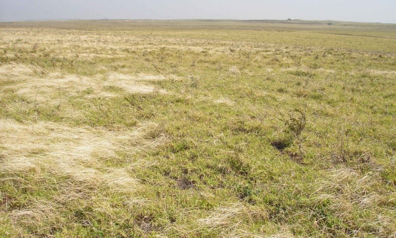
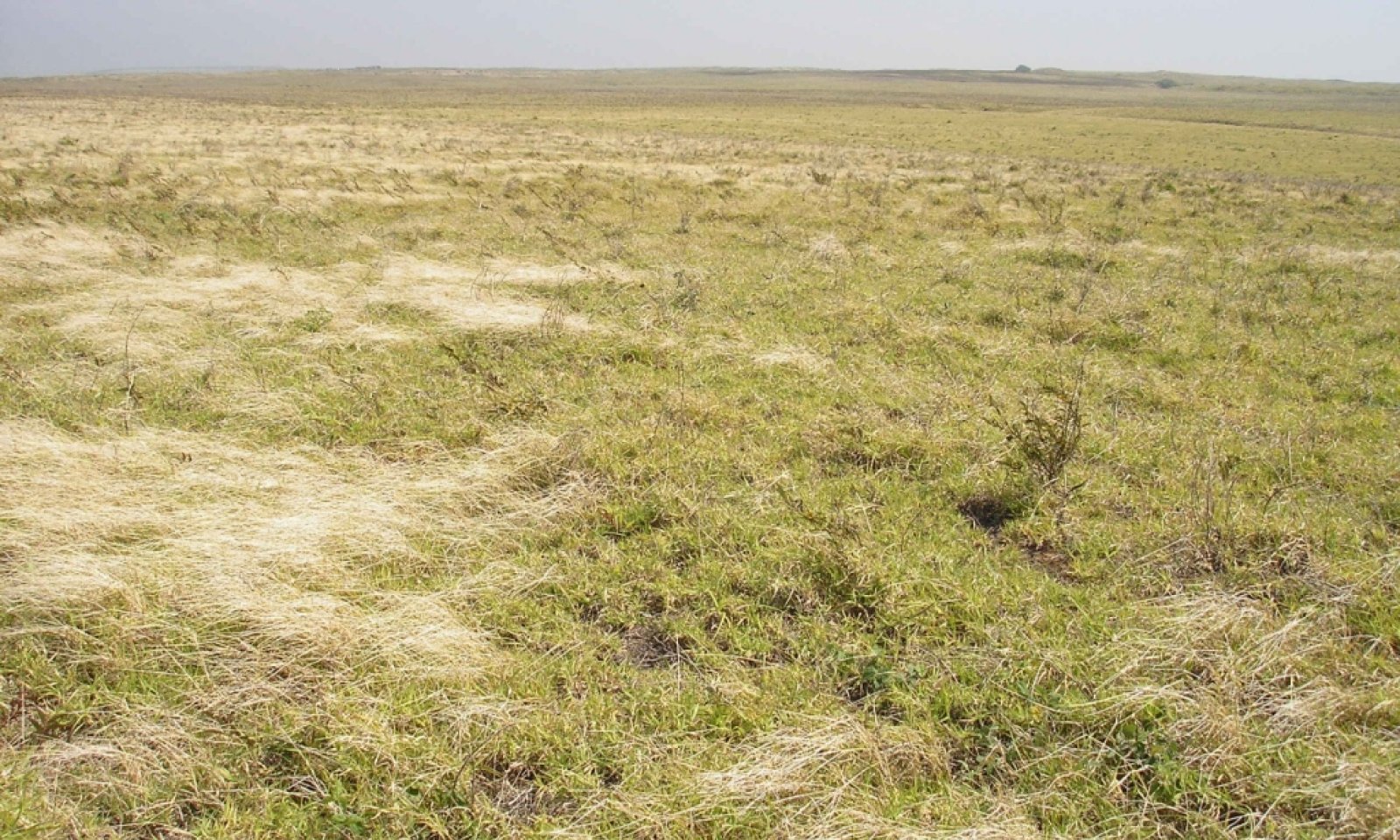
Figure 2. 1.1 Desert Mid-Grass
The interpretive plant community for this site is a naturalized plant community. This plant community evolved in recent history. The aspect is open grassland composed principally of a continuous cover of buffelgrass. Most of the plants in this community evolved in ecosystems where there was a presence of herbivores or wildfire was a natural force. Total annual, average, air-dry vegetation production can range from 800 to 3,500 pounds per acre, and averages about 2,000 pounds per acre during an average or normal rainfall year. The major plant growth period is from mid-fall to late winter.
Figure 3. Annual production by plant type (representative values) or group (midpoint values)
Table 5. Annual production by plant type
| Plant type | Low (lb/acre) |
Representative value (lb/acre) |
High (lb/acre) |
|---|---|---|---|
| Grass/Grasslike | 680 | 1700 | 2975 |
| Shrub/Vine | 160 | 400 | 700 |
| Forb | 40 | 100 | 175 |
| Total | 880 | 2200 | 3850 |
Table 6. Ground cover
| Tree foliar cover | 0% |
|---|---|
| Shrub/vine/liana foliar cover | 0% |
| Grass/grasslike foliar cover | 1-5% |
| Forb foliar cover | 1-3% |
| Non-vascular plants | 0% |
| Biological crusts | 0-5% |
| Litter | 5-10% |
| Surface fragments >0.25" and <=3" | 0-5% |
| Surface fragments >3" | 5-10% |
| Bedrock | 0% |
| Water | 0% |
| Bare ground | 1-5% |
Table 7. Soil surface cover
| Tree basal cover | 0-3% |
|---|---|
| Shrub/vine/liana basal cover | 1-10% |
| Grass/grasslike basal cover | 85-90% |
| Forb basal cover | 5-15% |
| Non-vascular plants | 0% |
| Biological crusts | 0% |
| Litter | 20-25% |
| Surface fragments >0.25" and <=3" | 0-5% |
| Surface fragments >3" | 5-10% |
| Bedrock | 0% |
| Water | 0% |
| Bare ground | 1-5% |
Figure 4. Plant community growth curve (percent production by month). HI1571, Naturalized Desert Mid-Grass. Warm season grasses.
| Jan | Feb | Mar | Apr | May | Jun | Jul | Aug | Sep | Oct | Nov | Dec |
|---|---|---|---|---|---|---|---|---|---|---|---|
| J | F | M | A | M | J | J | A | S | O | N | D |
| 30 | 30 | 13 | 1 | 1 | 1 | 1 | 1 | 1 | 1 | 5 | 15 |
State 2
Naturalized Grass & Shrubland
Community 2.1
Mid-Seral Mixed
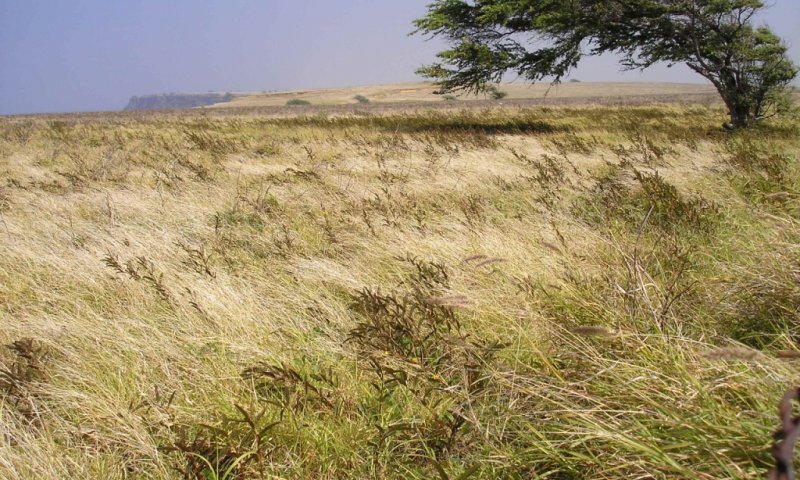
Figure 5. 2.1 Mid Seral Mixed
This plant community occurs with continuous grazing pressure. Recognition of this plant community will enable the land user to implement key management decisions before a significant economic/ecological threshold is crossed. Key grass species such as buffelgrass and piligrass have been reduced to remnant amounts. Pitted beardgrass, with lesser amounts of swollen fingergrass, and Japanese tea have increased in abundance and dominate the community. This community provides significantly less forage amounts than the interpretive community.
Figure 6. Plant community growth curve (percent production by month). HI1571, Naturalized Desert Mid-Grass. Warm season grasses.
| Jan | Feb | Mar | Apr | May | Jun | Jul | Aug | Sep | Oct | Nov | Dec |
|---|---|---|---|---|---|---|---|---|---|---|---|
| J | F | M | A | M | J | J | A | S | O | N | D |
| 30 | 30 | 13 | 1 | 1 | 1 | 1 | 1 | 1 | 1 | 5 | 15 |
State 3
Naturalized Low-Seral Weedy Grass & Shrubland
Community 3.1
Low-Seral Mixed
Figure 7. 3.1 Low Seral Mixed
This plant community occurs with continuous grazing pressure. Recognition of this plant community will enable the land user to implement key management decisions before a significant economic/ecological threshold is crossed. Key grass species such as pitted beardgrass and swollen fingergrass have been reduced to remnant amounts. Sod patches of Bermudagrass, with lesser amounts of uhaloa and ilima have increased in abundance and dominate the community. Sweet acacia and lantana can also have begun to invade this site. This community provides significantly less forage amounts than the interpretive community.
Figure 8. Plant community growth curve (percent production by month). HI1571, Naturalized Desert Mid-Grass. Warm season grasses.
| Jan | Feb | Mar | Apr | May | Jun | Jul | Aug | Sep | Oct | Nov | Dec |
|---|---|---|---|---|---|---|---|---|---|---|---|
| J | F | M | A | M | J | J | A | S | O | N | D |
| 30 | 30 | 13 | 1 | 1 | 1 | 1 | 1 | 1 | 1 | 5 | 15 |
Transition T1
State 1 to 2
With continuous livestock grazing and/or human-induced fire, this site moves toward the 2.1 Mid-Seral Mixed Community and eventually the 3.1 Low Seral Mixed Community.
Restoration pathway R2
State 2 to 1
With prescribed grazing and control/removal of fire, this plant community can be shifted to the 1.0 Reference State.
Conservation practices
| Land Reclamation, Fire Control | |
|---|---|
| Prescribed Grazing |
Transition T2
State 2 to 3
With continued heavy grazing pressure, this site will move toward the 3.1 Low Seral Mixed Community.
Restoration pathway R3a
State 3 to 1
The pathway back to the 1.0 Reference community is with prescribed grazing.
Conservation practices
| Prescribed Grazing |
|---|
Restoration pathway R3b
State 3 to 2
The pathway back to the 2.1 Mid-Seral Mixed Community is with prescribed grazing.
Conservation practices
| Prescribed Grazing |
|---|
Additional community tables
Table 8. Community 1.1 plant community composition
| Group | Common name | Symbol | Scientific name | Annual production (lb/acre) | Foliar cover (%) | |
|---|---|---|---|---|---|---|
|
Grass/Grasslike
|
||||||
| 1 | Naturalized Warm Season Mid Bunch Grasses | 1700–1800 | ||||
| buffelgrass | PECI | Pennisetum ciliare | 1600–1800 | – | ||
| crimson fountaingrass | PESE3 | Pennisetum setaceum | 1–20 | – | ||
| guineagrass | URMA3 | Urochloa maxima | 1–20 | – | ||
| 2 | Naturalized Warm Season Short Bunch Grasses | 1–100 | ||||
| pitted beardgrass | BOPE2 | Bothriochloa pertusa | 1–20 | – | ||
| swollen fingergrass | CHBA10 | Chloris barbata | 1–20 | – | ||
| 3 | Naturalized Warm Season Stoloniferous Short Grasse | 1–20 | ||||
| Bermudagrass | CYDA | Cynodon dactylon | 1–20 | – | ||
| stargrass | CYPL2 | Cynodon plectostachyus | 1–20 | – | ||
| 4 | Naturalized Warm Season Annual Grasses | 1–20 | ||||
| hooked bristlegrass | SEVE3 | Setaria verticillata | 1–20 | – | ||
| 5 | Native Warm Season Mid Bunch Grasses | 1–100 | ||||
| tanglehead | HECO10 | Heteropogon contortus | 1–100 | – | ||
| hardstem lovegrass | ERAT | Eragrostis atropioides | 1–20 | – | ||
| 6 | Native Warm Season Annual Grasses | 1–20 | ||||
| Maui panicgrass | PAPE3 | Panicum pellitum | 1–20 | – | ||
| torrid panicgrass | PATO | Panicum torridum | 1–20 | – | ||
| kakonakona | PAXE | Panicum xerophilum | 1–20 | – | ||
|
Forb
|
||||||
| 7 | Naturalized Forbs | 20–100 | ||||
| uhaloa | WAIN | Waltheria indica | 1–100 | – | ||
| Cuban jute | SIRH | Sida rhombifolia | 1–40 | – | ||
| golden crownbeard | VEEN | Verbesina encelioides | 1–20 | – | ||
| Australian saltbush | ATSE | Atriplex semibaccata | 1–20 | – | ||
| sensitive partridge pea | CHNIG | Chamaecrista nictitans ssp. patellaria var. glabrata | 1–20 | – | ||
| purple bushbean | MAAT80 | Macroptilium atropurpureum | 1–20 | – | ||
| Madagascar ragwort | SEMA15 | Senecio madagascariensis | 1–20 | – | ||
|
Shrub/Vine
|
||||||
| 8 | Naturalized Shrubs, Half-Shrubs, and Trees | 20–100 | ||||
| kiawe | PRPA4 | Prosopis pallida | 20–100 | – | ||
| ‘ilima | SICO | Sida cordifolia | 1–20 | – | ||
| sweet acacia | ACFA | Acacia farnesiana | 1–20 | – | ||
| anil de pasto | INSU | Indigofera suffruticosa | 1–20 | – | ||
| lantana | LACA2 | Lantana camara | 1–20 | – | ||
| white leadtree | LELE10 | Leucaena leucocephala | 1–20 | – | ||
Interpretations
Animal community
Animal Community - Wildlife Interpretations
This site provides habitat to a variety of small and medium-sized birds such as doves, the Northern cardinal, the chestnut-bellied sand grouse, and the gray francolin. The introduced axis deer may also use this site. Importantly, the site provides habitat and hunting grounds for the native Hawaiian hawk (I`o) and the Hawaiian owl (Pueo).
Animal Community - Grazing Interpretations
The naturalized plant community on this site is suitable for grazing by all kinds and classes of livestock, at any season, particularly cattle. However, this site is best utilized for mid-fall to late winter grazing as this is the major plant growth period. This site is suited for grazing by both cow-calf operations and stocker operations. However, sheep can be grazed on this site as well. This site is poorly suited to continuous year-long use if the interpretive naturalized plant community is to be maintained. Herbaceous forage can be deficient in protein during the drier summer months.
Hydrological functions
This site is dominated by soils in hydrologic groups B and C. Infiltration and runoff potential for this site varies from low to moderate depending on soil hydrologic group and ground cover. Areas where ground cover is less than 50% have the greatest potential to have reduced infiltration and higher runoff (refer to Section 4, NRCS National Engineering Handbook (NEH-4) for runoff quantities and hydrologic curves).
Recreational uses
Because of the climate of the major land resource area, and the open grassland nature of this site, it composes a significant portion of the open vistas that are an important part of the charm and character of South and West Hawaii, as well as portions of Maui. The naturalized shrub and grass species makes this site pleasing to view. Its open aspect makes it an excellent location for horseback riding, hiking, bird watching, and hunting. The open space nature of this site is currently being threatened, is some areas, due to the development of subdivisions.
Wood products
No appreciable wood products are present on the interpretive plant community for this site.
Other products
None
Other information
None
Supporting information
Type locality
| Location 1: Hawaii County, HI | |
|---|---|
| Latitude | 18° 55′ 35″ |
| Longitude | 155° 41′ 6″ |
| General legal description | Hawaii County, Island of Hawaii, Ka’u District |
Contributors
Joseph A. May
Loretta J. Metz
Approval
Kendra Moseley, 5/08/2025
Rangeland health reference sheet
Interpreting Indicators of Rangeland Health is a qualitative assessment protocol used to determine ecosystem condition based on benchmark characteristics described in the Reference Sheet. A suite of 17 (or more) indicators are typically considered in an assessment. The ecological site(s) representative of an assessment location must be known prior to applying the protocol and must be verified based on soils and climate. Current plant community cannot be used to identify the ecological site.
| Author(s)/participant(s) | Loretta J. Metz, Earl W. Spence; David Clausnitzer |
|---|---|
| Contact for lead author | Loretta.Metz@hi.usda.gov |
| Date | 01/29/2009 |
| Approved by | Kendra Moseley |
| Approval date | |
| Composition (Indicators 10 and 12) based on | Annual Production |
Indicators
-
Number and extent of rills:
None. -
Presence of water flow patterns:
None. -
Number and height of erosional pedestals or terracettes:
No erosional pedestals or terracettes are present on this site, regardless of wet or dry season. -
Bare ground from Ecological Site Description or other studies (rock, litter, lichen, moss, plant canopy are not bare ground):
Bare ground should never exceed 5% in any season. -
Number of gullies and erosion associated with gullies:
No gullies or erosion associated with gullies are be present on this site. -
Extent of wind scoured, blowouts and/or depositional areas:
None. -
Amount of litter movement (describe size and distance expected to travel):
No litter movement is expected, regardless of the season. -
Soil surface (top few mm) resistance to erosion (stability values are averages - most sites will show a range of values):
Values ranging from 2 to 4 are common. -
Soil surface structure and SOM content (include type of structure and A-horizon color and thickness):
-
Effect of community phase composition (relative proportion of different functional groups) and spatial distribution on infiltration and runoff:
Warm season perennial mid-height bunchgrass changes to invasive shrubs (lantana and haole-koa). This change will reduce the infiltration and increase the runoff. -
Presence and thickness of compaction layer (usually none; describe soil profile features which may be mistaken for compaction on this site):
None. -
Functional/Structural Groups (list in order of descending dominance by above-ground annual-production or live foliar cover using symbols: >>, >, = to indicate much greater than, greater than, and equal to):
Dominant:
Naturalized, warm season, mid-height perennial bunchgrasses >>Sub-dominant:
Naturalized, warm season, non-leguminous forbs =Other:
Naturalized, leguminous shrubs/trees.Additional:
-
Amount of plant mortality and decadence (include which functional groups are expected to show mortality or decadence):
Plant mortality is very low.
Decadence of herbaceous plants is common due to drought, high evapotranspiration rates, ocean salt-spray, and prolific winds that are common on the site. -
Average percent litter cover (%) and depth ( in):
Litter cover above 25% can maintain site stability and function, provided that plant gap does not exceed an average of 1.5-feet and annual production remains in the expected range. -
Expected annual annual-production (this is TOTAL above-ground annual-production, not just forage annual-production):
2000 pounds per acre. -
Potential invasive (including noxious) species (native and non-native). List species which BOTH characterize degraded states and have the potential to become a dominant or co-dominant species on the ecological site if their future establishment and growth is not actively controlled by management interventions. Species that become dominant for only one to several years (e.g., short-term response to drought or wildfire) are not invasive plants. Note that unlike other indicators, we are describing what is NOT expected in the reference state for the ecological site:
Prosopis pallida (kiawe); Leucaena leucocephala (haole-koa); Acacia farnesiana (klu); Lantana camara (lantana); Waltheria indica (uhaloa); Chamaecrista nictitans (Japanese tea). -
Perennial plant reproductive capability:
Capacity to reproduce should not be reduced or impaired in the reference state.
Print Options
Sections
Font
Other
The Ecosystem Dynamics Interpretive Tool is an information system framework developed by the USDA-ARS Jornada Experimental Range, USDA Natural Resources Conservation Service, and New Mexico State University.
Click on box and path labels to scroll to the respective text.