Natural Resources
Conservation Service
Ecological site PX136X00X340
Mesic Temperature Regime, Acidic Upland Colluvial Forest
Last updated: 5/02/2025
Accessed: 05/19/2025
General information
Provisional. A provisional ecological site description has undergone quality control and quality assurance review. It contains a working state and transition model and enough information to identify the ecological site.
MLRA notes
Major Land Resource Area (MLRA): 136X–Southern Piedmont
This MLRA is on a large piedmont underlain by metamorphic and igneous bedrock. It stretches from north-central Virginia to east-central Alabama, running parallel to the Appalachian highlands to the northwest and the Atlantic coast to the southeast.
MLRA 136 has only subtle climatic differences with MLRA 148 (Northern Piedmont), with which it shares a common geologic origin. This adjacent MLRA sits to the north. Along the fall line, it shares a boundary with MLRA 133A (Southern Coastal Plain), MLRA 137 (Carolina and Georgia Sand Hills), and 133C (Gulf Coastal Plain). Here, unconsolidated Coastal Plain sediments intersect the much older Piedmont bedrock. Along it's northwestern boundary, it sits adjacent to MLRAs 130B (Southern Blue Ridge), 130A (Northern Blue Ridge), and 128 (Southern Appalachian Ridges and Valleys). These MLRAs are distinguished from the Southern Piedmont by topographic and elevational differences, as well as differences in the age, origin, and degree of metamorphism of the underlying bedrock.
Five states are intersected by the MLRA, including North Carolina (29 percent), Georgia (27 percent), Virginia (20 percent), South Carolina (17 percent), and Alabama (7 percent). The MLRA extent makes up about 63,720 square miles (165,034 square kilometers).
MLRA PHYSIOGRAPHY
The landscape is generally rolling to hilly, with a well-defined drainage pattern. Streams have dissected the original Piedmont plateau, forming narrow ridgetops, somewhat broad interfluves, and short, steep side slopes adjacent to the streams and drainageways. With some exceptions, the valley floors are generally narrow and make up about 10 percent or less of the land area. The associated stream terraces are generally small and of minor extent.
The landscape is moderately dissected overall, with isolated erosional remnants (monadnocks) and other areas of high topographic relief interspersed. Over most of the MLRA, elevation ranges from approximately 325 to 1,315 feet (100 to 400 meters), with elevations generally increasing toward the Appalachian Highlands, in the upper Piedmont, and decreasing toward the Coastal Plain, in the lower Piedmont.
The major rivers that cross this area en route to the ocean include, from north to south, the James, Roanoke, Cape Fear, Savannah, Altamaha, Chattahoochee, and Alabama Rivers. These rivers typically originate within the Piedmont or in the Blue Ridge. They flow east and south across the Coastal Plain and empty into the Atlantic Ocean or the Gulf of America.
MLRA GEOLOGY
Precambrian and Paleozoic metamorphic and igneous rocks underlie almost all of this MLRA. The dominant metamorphic rock types include gneiss, schist, slate, argillite, and phyllite, among others. Dominant igneous rock types include granite and other related felsic crystalline rocks. Mafic intrusive rocks, including gabbro, diabase, amphibolite, and other dark colored rocks, underlie a minority of the upland landscape. These mafic intrusions crop out in the form of dikes and sills, and often weather to produce soils high in base cations.
The Carolina Slate Belt runs lengthwise through the east-central part of the MLRA, in southern Virginia, North Carolina, South Carolina, and the eastern-most part of the Georgia Piedmont. This region is underlain by fine-grained metasedimentary and metavolcanic rock, which generally weathers to produce soils high in silt.
From Virginia to North Carolina, and in a single county in South Carolina, fault-bounded Triassic Basins are scattered amongst the igneous and metamorphic uplands. These basins are underlain by Triassic and Jurassic siltstone, shale, sandstone, and mudstone, which were laid down in response to continental rifting and subsequent erosion during the Mesozoic era.
MLRA SOILS
The dominant soil orders of the MLRA are Ultisols, Inceptisols, and Alfisols. Ultisols and Alfisols are typically found on more stable landforms, such as interfluves, gentle hillslopes, broad ridgetops, and stream terraces, while Inceptisols are typically found on less stable landforms, including flood plains, steep hillslopes, and narrow ridgetops.
Soils of the region predominantly have a thermic temperature regime, a udic moisture regime, and generally have kaolinitic or mixed mineralogy. In the upper Piedmont of Virginia and North Carolina however, soils have a mesic soil temperature regime, as depicted in figure 2. The mesic soil temperature regime portion of the MLRA is oriented from northeast to southwest and occupies approximately 18 percent of the MLRA extent, or 11,729 square miles (30,377 square kilometers).
Broadly speaking, soils of the Southern Piedmont uplands are shallow to very deep, well drained, and loamy or clayey. Soils of the river valleys are generally very deep, well to poorly drained, and loamy. Soils tend to be finer-textured than in Coastal Plain regions.
MLRA CLIMATE
In general, precipitation is evenly distributed throughout the year in this MLRA, with occasional drought-like conditions extending from late summer into autumn. During the growing season, most of the rainfall comes from high-intensity, convective thunderstorms. Significant moisture also comes from the movement of warm and cold fronts across the MLRA from November to April. High amounts of rain can also occur during hurricanes, usually during the months of August through October.
Over most of the MLRA, snowfall is typically light, though overall, the mesic soil temperature regime portion of the MLRA features colder temperatures, more snowfall, and a shorter growing season than in the thermic portion. The cooler climate in this region supports an increase in species with northern or Blue Ridge affinities. Both the mean annual temperature and the length of the freeze-free period increase from north to south and with decreasing elevation from the upper to the lower Piedmont.
MLRA LAND USE AND RESOURCES
Once largely cultivated, much of this region is now planted to loblolly pine or has reverted to successional pine and hardwood forests. The more productive lands support small to medium-size family farms that produce crops and livestock, while the less productive lands have been in forest for some time. Most of the open areas are used for grazing beef cattle, though in years past, dairy cattle were also important to the local economy. The principal crops of the region include corn, soybeans, and small grains. Burley tobacco remains a crop of local importance. Cotton is grown in the thermic soil temperature regime portion of the MLRA.
Several major land cover transformations have occurred in the Southern Piedmont over the past several centuries; from open woodlands sculpted by fire, to farmland, to closed forests and planted pine, past land uses have played an outsized role in shaping present-day soils and vegetation patterns in the region. Land-use intensity peaked with the arrival of the industrial revolution, which gradually increased demand for textiles. Cotton became the dominant crop over much of the region.
In spite of early successes, two centuries of poor management practices accelerated soil erosion, stripping away the fertility and moisture-supplying capacity of soils. In addition to soil losses in the uplands, legacy sediments derived from the eroded land rapidly accumulated in the river valleys below, often leading to changes in hydrology and flooding frequency.
After being stripped of it's loamy topsoil, many areas of the Piedmont had been so badly eroded as to render the land unsuitable or economically impractical for agriculture. The effects of erosion were widespread, with cumulative soil loss estimates ranging from 5 to 10 inches on average. The steeper slopes, which had often been cleared and farmed at the height of the Cotton era, generally suffered greater losses. By the 1930's, crop production was in rapid decline in the Southern Piedmont. The loss of soil productivity due to erosion, losses to the cotton boll weevil, development of synthetic fibers, and the onset of the Great Depression all contributed to rapid abandonment of cropland. By 1960, cropland acres had decreased by more than 50 percent in nearly every county in the Southern Piedmont.
While crop production is still important today on the more productive lands, those of lower productivity, or those that were subject to severe erosion, were often abandoned some time ago. Typically, they have either reverted to forest, or have been converted to other uses. Although the productivity of soils was greatly reduced through erosion, less intensive land uses such as grazing and forestry were still feasible. These land uses gained popularity as patterns of urban migration, low commodity prices, and other factors gradually made crop production less economical on the marginal lands.
In recent years, large-scale adoption of soil conservation practices have led to better outcomes with respect to erosion in much of MLRA, increasing the economic viability and long-term sustainability of Piedmont farms. Despite some success, water erosion remains one of the most important soil resource concerns in the MLRA.
Other major resource concerns include increasing conversion of prime farmland and farmland of statewide importance to urban uses. Throughout the MLRA, metropolitan areas are expanding into lands that have historically been used for timber or agriculture. This change in land use is occurring rapidly in the corridor called the Piedmont Crescent, which extends from Atlanta, Georgia, to Raleigh, North Carolina.
HISTORIC VEGETATION COVER
Over most of the Southern Piedmont uplands, the historic oak-hickory, or oak-hickory-pine forest, once covered large portions of the landscape. It was dominated by upland oaks, such as white oak (Quercus alba), northern red oak (Quercus rubra), and southern red oak (Quercus falcata), with a smaller contribution from hickories (Carya spp.) and pines. The principal pine species are shortleaf pine (Pinus echinata), loblolly pine (Pinus taeda), and to the north and west, Virginia pine (Pinus virginiana). In the southernmost and easternmost portions of the MLRA, the historic montane longleaf pine forest, dominated by longleaf pine (Pinus palustris), shortleaf pine (P. echinata), and dry-site oaks, was found on ridgetops and steep south or west-facing slopes.
According to historic accounts, forests and woodlands of the past were generally more open and park-like, having been exposed to a more frequent fire regime. Piedmont prairies, likely maintained by Native Americans, were also reportedly common across the landscape, as were fire-maintained canebrakes along the streams (Trimble 1974; Daniels 1987; Griffith et al. 2002; Van Lear et al. 2004; Dearman and James 2019; Schomberg et al. 2020; USDA-NRCS 2022).
LRU notes
MLRA 136 is one of the largest MLRAs in the United States. It has a broad north-south and east-west extent and covers a wide range of elevations. The MLRA is partitioned by the mesic-thermic line, which divides the MLRA into mesic and thermic soil temperature regimes (figure 2.). The mesic soil temperature regime was delineated based on estimates of the native range of loblolly pine, which was historically absent in this part of the MLRA. In addition, this region is said to represent the northern and western limits of cotton production, an important crop to the south and east.
ESDs developed for this MLRA were split geographically into mesic and thermic ecological site concepts. Climate variation across the MLRA extent warrants the development of Land Resource Unit (LRU) classifications, to further subdivide the MLRA and support more precise Ecological Site Descriptions.
Classification relationships
APPLICABLE USNVC ASSOCIATIONS
CEGL008465 Fagus grandifolia - Quercus rubra / Cornus florida / Polystichum acrosticoides - Hexastylis virginica.
APPLICABLE EPA ECOREGIONS
Level III: 45. Piedmont
Level IV: 45e. Northern Inner Piedmont (EPA 2013).
APPLICABLE USFS ECOLOGICAL UNITS
Domain: Humid Temperate
Division: Subtropical
Ecological province: 231. Southeastern Mixed Forest
Ecological sections: 231I.Central Appalachian Piedmont (Cleland et al. 2007).
Based on the USGS physiographic classification system (Fenneman and Johnson 1946), most of MLRA 136 is in the Piedmont Upland section of the Piedmont province, in the Appalachian Highlands division.
Ecological site concept
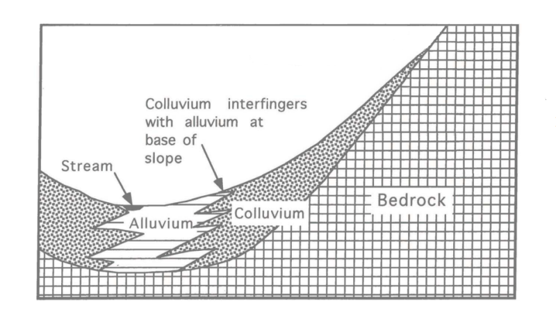
This ecological site includes moist acidic uplands in colluvial areas, at the base of slopes and on cove-like head slopes, in highly dissected and higher elevation parts of the Southern Piedmont. It is geographically restricted to the mesic soil temperature regime portion of the MLRA. Generally, these moist slopes sit at the base of prominent ridges, high hills, or isolated monadnocks, on footslopes and toeslopes. These environments are protected to varying degrees from the elements, including sun, wind, and historically fire, and usually receive water from upslope. Although true cove forests are restricted to the Southern Blue Ridge, cove-like landforms are not uncommon in the Piedmont, in the more rugged parts of the MLRA. These forests generally lack some of the characteristic montane species featured in true cove forests.
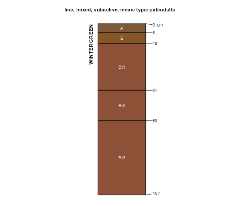
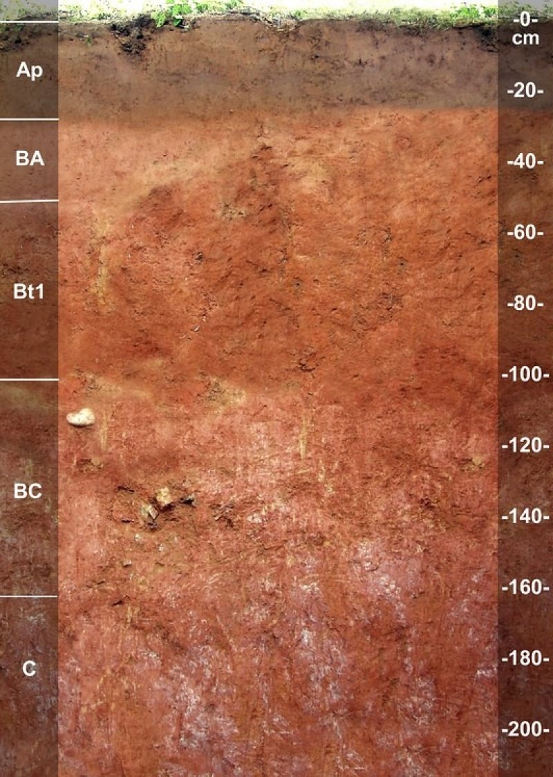
Soils on this ecological site are typically deep to very deep, well drained Ultisols. Parent materials are colluvium, or a mixture of colluvium and slope alluvium, derived from acidic igneous or metamorphic rocks.
The reference state supports a closed canopy forest dominated by moisture-loving tree species, including American beech (Fagus grandifolia), northern red oak (Quercus rubra), and tuliptree (Liriodendron tulipifera). Dominant land uses include pasture and hayland, planted pine, and wildlife habitat. Soils have historically been used for crop production wherever feasible.
ES CHARACTERISTICS SUMMARY
• Mesic soil temperature regime
• Occurs on Piedmont uplands, on footslopes and toeslopes, in highly dissected and higher elevation parts of the MLRA
• Base saturation: < 35 percent in the subsoil
• Seasonal high water table: usually absent within 72 inches of the soil surface
• Depth to bedrock: ≥ 40 inches, usually deeper
• The available water storage capacity of the profile (from the soil surface to 80 inches, or to paralithic or lithic bedrock, whichever is shallower) is greater than or equal to 4 inches, usually higher
• Parent materials: colluvium, or a mixture of colluvium and slope alluvium
• Soils: deep to very deep, well drained Ultisols
Associated sites
| PX136X00X380 |
Mesic Temperature Regime, Acidic High Hills and Isolated Ridges, Depth Restriction, Dry Found in higher and more exposed landscape positions upslope. Soils are much shallower to bedrock (< 40 inches from the soil surface, usually shallower). Moisture-loving plant species, such as northern red oak (Quercus rubra) and American beech (Fagus grandifolia), decrease in abundance, while dry-site species increase. |
|---|---|
| PX136X00X160 |
Mesic Temperature Regime, High Terraces, Very Rare Inundation Found in lower landscape positions, in river valleys or along small streams, on high stream terraces. The potential for flooding is higher and the depth to the seasonal high water table is often shallower (18 inches or greater from the soil surface). Bottomland oaks, such as willow oak (Quercus phellos), tend to be more abundant in the reference state. |
Similar sites
| PX136X00X160 |
Mesic Temperature Regime, High Terraces, Very Rare Inundation Found in lower landscape positions, in river valleys or along small streams, on high stream terraces. The potential for flooding is higher and the depth to the seasonal high water table is often shallower (12 inches or greater from the soil surface). Bottomland oaks, such as willow oak (Quercus phellos), tend to be more abundant in the reference state. |
|---|---|
| F130BY005WV |
Mesic Colluvium Cool Aspect A similar ecological site typical of acidic coves of the Southern Blue Ridge. Montane species are more important in the canopy, including sweet birch (Betula lenta) and eastern hemlock (Tsuga canadensis), among others. |
| PX136X00X840 |
Acidic Upland Colluvial Forest The soil temperature regime is thermic, occurring within the native range of loblolly pine (Pinus taeda). |
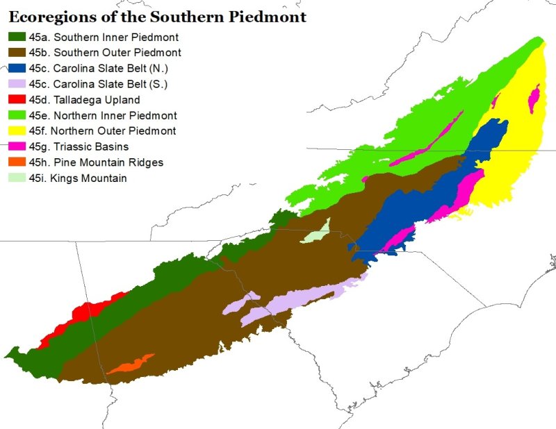
Figure 1. EPA level IV ecoregions of the Southern Piedmont (45).
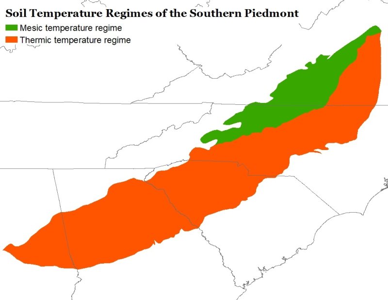
Figure 2. Spatial illustration of soil temperature regimes of the Southern Piedmont.
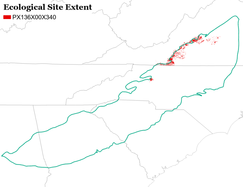
Figure 3. Spatial extent of this ecological site representing the major areas where this site is important on the landscape.
Table 1. Dominant plant species
| Tree |
(1) Fagus grandifolia |
|---|---|
| Shrub |
(1) Euonymus americanus |
| Herbaceous |
(1) Polystichum acrostichoides |
Legacy ID
F136XY340VA
Click on box and path labels to scroll to the respective text.
Ecosystem states
States 1, 5 and 6 (additional transitions)
States 2, 5 and 6 (additional transitions)
| T1A | - | Clearcut logging or other large-scale disturbances that cause canopy removal. |
|---|---|---|
| T1B | - | Selective removals of the most valuable timber specimens, leaving inferior trees behind. |
| T1C | - | Mechanical tree/brush/stump/debris removal, seedbed preparation, and planting of perennial grasses and forbs. |
| T1D | - | Mechanical tree/brush/stump/debris removal, seedbed preparation, applications of fertilizer/lime, and planting of crop or cover crop seed. |
| T2A | - | Long-term natural succession. |
| T2B | - | Site preparation and tree planting. |
| T2C | - | Mechanical tree/brush/stump/debris removal, seedbed preparation, and planting of perennial grasses and forbs. |
| T2D | - | Mechanical tree/brush/stump/debris removal, seedbed preparation, applications of fertilizer/lime, weed control, planting of crop or cover crop seed. |
| T3A | - | Clearcut logging or other large-scale disturbances that cause canopy removal. |
| T3C | - | Mechanical tree/brush/stump/debris removal, seedbed preparation, applications of fertilizer/lime, weed control, and planting of perennial grasses and forbs. |
| T3D | - | Mechanical tree/brush/stump/debris removal, seedbed preparation, applications of fertilizer/lime, weed control, planting of crop or cover crop seed. |
| T4A | - | Abandonment of forestry practices. |
| T4B | - | Timber harvest, mechanical stump and debris removal, seedbed preparation, and planting of perennial grasses and forbs. |
| T4C | - | Timber harvest, mechanical stump and debris removal, seedbed preparation, fertilizer/lime, weed control, planting of crop or cover crop seed. |
| T5A | - | Long-term cessation of grazing. |
| T5B | - | Site preparation and tree planting. |
| T5C | - | Seedbed preparation, applications of fertilizer/lime, weed control, and planting of crop or cover crop seed. |
| T6A | - | Agricultural abandonment. |
| T6B | - | Site preparation and tree planting. |
| T6C | - | Seedbed preparation, weed control, and planting of perennial grasses and forbs. |
State 2 submodel, plant communities
| 2.1A | - | Clearcut logging. |
|---|---|---|
| 2.2A | - | Natural succession. |
| 2.2B | - | Brush management. |
| 2.3A | - | Natural succession. |
State 6 submodel, plant communities
| 6.1A | - | Conventional tillage is reintroduced. |
|---|---|---|
| 6.2A | - | Implementation of conservation tillage and other soil conservation practices |