Ecological dynamics
Provisional Ecological Site (PES): F123XY002TN - Limestone Flats
Major Land Resource Area (MLRA) 123
This PES describes ecological communities likely to be found on soil in the PES soil grouping. Future field work is required to develop detailed and accurate ecological site descriptions (ESDs) that can be used by conservation planners for restoration and planning activities. This PES describes hypotheses based on available data from many different sources and has not been developed using site-specific ecological field monitoring. Future ESD development will result in this initial PES group being split into more refined ecological communities.
Soil series currently included in this project are Agee, Almaville, Bluestocking, Burgin Capshaw, Dowellton, Dunning, Eagleville, Godwin, Lanton, Minter, Norene, Roellen, Tupelo, and Woodmont.
Forest Vegetation as listed in Official Series Descriptions (OSDs):
Agee: Native vegetation was a mixture of canebrakes and hardwood trees including oak, sycamore, sweetgum, maple, willow and ash.
Almaville: Forested areas are chiefly in oaks, gums, hackberry, elms, redcedar, and hickory trees.
Bluestocking: The native vegetation was mixed hardwoods.
Burgin: no OSD found
Capshaw: A few areas are in woodland consisting of oak, hickory, maple, elm, hackberry, beech, dogwood, and red cedar.
Dowellton: Forests are oak, hickory, maple, elm, ash, and hackberry.
Dunning: Native forest is water-tolerant hardwoods such as red maple, sycamore, gums, boxelder, willow, pin oak, water oak, swamp white oak, and cottonwood, interspersed with glades of cane, grass, and sedge.
Eagleville: Native hardwoods including oak, hickory, elm, maple, sycamore, and ash; also much of these areas were in canebrakes in places.
Godwin: Native vegetation was hardwood forest.
Lanton: The original vegetation was hardwood forest.
Minter: Principal vegetation of wooded areas is bald cypress, oak, sweetgum, blackgum, water tupelo, and pine.
Norene: Native vegetation is water-tolerant hardwoods such as water oak, willow oak, American elm, sycamore, hackberry, red maple, sweetgum and eastern cottonwood.
Roellen: The native vegetation was mixed hardwood forest, chiefly of bottomland oaks, sycamore, sweetgum, willow, and green ash.
Tupelo: Forested areas are in oak, hickory, ash, sweetgum, and yellow poplar.
Woodmont: The native vegetation is mixed hardwoods.
Trees listed in NASIS for the mapunits in this PES grouping are as follows:
Agee: cherrybark oak, water oak, sweetgum, sycamore, cottonwood
Almaville: pin oak, southern red oak, loblolly pine
Bluestocking: tulip tree
Burgin: eastern cottonwood, sweetgum, swamp white oak
Capshaw: northern red oak, southern red oak, tulip tree, loblolly pine
Dowellton: water oak, sweetgum, loblolly pine
Dunning: swamp white oak, sweetgum, boxelder, red maple, eastern cottonwood (Dunning-Lindside loamy mapunit: tulip tree, white ash, black walnut)
Eagleville: water oak, swamp white oak, sweetgum, eastern cottonwood, green ash
Godwin: water oak, sweetgum, green ash, eastern cottonwood
Lanton: sweetgum, eastern cottonwood, loblolly pine
Minter: swamp white oak, sweetgum, green ash, overcup oak
Norene: red maple, eastern cottonwood, water oak, American sycamore, loblolly pine
Roellen: water oak, sweetgum, eastern cottonwood, cherrybark oak
Tupelo: swamp white oak, sweetgum, southern red oak, white oak, tulip poplar, American sycamore, loblolly pine
Woodmont: willow oak, cherrybark oak, sweetgum, white oak, tulip tree, shortleaf pine, loblolly pine.
Trees listed for PES map units in the USDA-NRCS Tennessee County Soil Surveys were
water oak, willow oak, northern red oak, sweetgum, cherrybark oak, southern red oak, white oak, tulip poplar, American sycamore, eastern cottonwood, American elm, loblolly pine, shortleaf pine, and hackberry. Bottomland oaks (especially water oak), sweetgum, and tulip poplar were the most commonly recorded species for the PES soil group overall.
Only two tree species can be selected for entry into the ESIS database as dominants: however, multiple tree species can be dominant on these sites and it will vary by drainage, aspect, soil depth, seed sources, management, disturbance history, fire regime, micro-topography, etc.
Ecological Dynamics
This PES describes forest communities generally found on limestone flats in the Nashville Basin area of Tennessee. Most mapunits in this initial PES grouping range from somewhat poorly drained to very poorly drained A few mapunits of Capshaw and Bluestocking soils are also included in this group. These soils are moderately well drained and will exhibit more upland vegetation species compared to the poorly drained sites. Future field monitoring of high quality sites is required to develop ecological site descriptions (ESDs) to support future conservation planning. Multiple ESDs will likely be developed from this initial PES group.
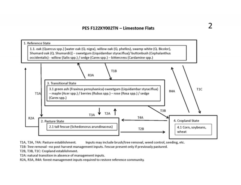
State 1. (Reference)
State 1, Phase 1.1: Plant species dominants:
oak (Quercus spp.) [water oak (Q. nigra), willow oak (Q. phellos), swamp white (Q. Bicolor), Shumard oak (Q. Shumardii)] – sweetgum (Liquidambar styraciflua)/ buttonbush (Cephalanthus occidentalis) - willow (Salix spp.) / sedges (Carex spp.) – bittercress (Cardamine spp.)
Trees on these sites will be varied but include a mix of oaks and other hardwoods. Water oak, willow oak, white oak, Shumard oak, swamp white oak, pin oak, cherrybark oak, southern red oak (more common on moderately well drained soils such as Capshaw) and northern red oak are recorded by NRCS on these sites. Other species present may include tulip poplar, sweetgum, eastern cottonwood, green ash, red maple, American elm, hackberry, black gum, and American sycamore. Shrub and vine species are variable and may include dogwood (Cornus spp.), American black elderberry (Sambucus canadensis), and northern spicebush (Lindera benzoin). Buttonbush (Cephalanthus occidentalis) and black willow (Salix nigra) may be components on the wetter sites.
The herbaceous layer will be highly variable. Herbaceous species may include sweet woodreed (Cinna arundinacea), eastern woodland sedge (Carex blanda), Virginia wildrye (Elymus virginicus), violet woodsorrel (Oxalis violacea), bulbous bittercress (Cardamine bulbosa), eastern poison ivy (Campsis radicans), Bidens spp., Pennsylvania bittercress (Cardamine pensylvanica), and Virginia springbeauty (Claytonia virginica). Field verification during ESD development is necessary to better characterize this community.
State 2. Pastureland
State 2, Phase 2.1: Managed Pasture.
Plant species dominants: Schedonorus arundinaceus (tall fescue)
Plant species within pasture phases depend on seeding, management, and concurrent land uses. As with all sites, soil characteristics and management inputs will influence production levels.
Many species of warm-season or cool-season grasses are feasible for these sites. Common forage species include tall fescue, orchard grass, Johnson grass, and timothy. Management of pasture sites should follow conservation planning standards and protocols which will benefit water quality, forage production, and soil health.
Transitioning this state to a reference condition would likely require extensive and long-term timber stand improvement practices including control of non-native vegetation and management for desired native tree, shrub and understory species.
Hydrological modifications such as tiling and draining may be present on these sites.
State 3. Transitional
State 3, Phase 3.1: Plant species dominants: tulip poplar (Liriodendron tulipifera) – sweetgum (Liquidambar styraciflua)/ berries (Rubus spp.) – rose (Rosa spp.) /
Tree species would be dependent upon several factors including severity and duration of disturbance, adjacent plant communities, available seed sources, post-disturbance management (control of invasive plants, grazing, etc.). A wide range of hardwoods is possible and may include tulip poplar, maple, ash, locust, black cherry, elm, and if seed sources are nearby, oaks sweetgum. and hickories. Common shrubs would be berries, roses, and briars. Grasses, forbs and herbs would be highly dependent upon current and previous land use.
Transitioning this state to a reference condition will require timber stand improvement practices to control non-native vegetation and manage for higher quality oak or hickory species. Hydrological modifications such as tiling and ditching may be present on these sites and should be evaluated if restoration to the reference condition is the management goal.
State 4. Croplands
Dependent upon seeding and management. Corn and soybeans are common. Hydrological modifications such as tiling and draining are often present on these sites
Abandonment of cropland would result in weed species taking over the site. Dozens of species are possible depending on the seed sources. Initially annual weeds would predominate followed annual and perennial grasses, shrubs, and finally, pioneer tree species such as pines, eastern red cedar, locusts, maples, ashes, and tulip poplar. Restoration would be required to return this State to a reference community, including oak and hickory regeneration, control of non-native vegetation, and planting of native understory species. Protection from disturbance (grazing) and restoration of the natural hydrology would also be required.
State 1
Forestland
This is the natural reference state of mixed oak hardwood forest. Species will vary depending on drainage, topography, and soils.
Community 1.1
Oak Forestland
This reference community is a oak-hickory or mixed oak hardwood forest.
State 2
Pastureland
This site is utilized as pasture and managed as such.
Community 2.1
Managed Pasture
This phase is a managed pasture. Management activities will depend on goals and objective of the landowner. Practices may include brush control, weed treatments, seeding, and fertilizing.
State 3
Transitional
In this STM, this state can be the result of major forest disturbance (logging, storm damage, fire) where the overstory trees have been removed or a natural progression from a managed pasture to an unmanaged pasture. Understory plants will differ
Community 3.1
Transitional (unmanaged) field
This phase is a successional state. In this STM, the transitional state could be either the result of forest disturbance (overstory removal by fire, logging or storm damage) or could be a natural transition from a pasture that is no longer being actively managed for forage.
State 4
Cropland
This is a managed cropland state. Species will be depended upon management objectives.
Common crops include corn, soybeans, and tobacco.
Community 4.1
Cropland
This phase is a cropland that would be intensively managed for corn, soybeans, or other cash crops. These sites may have hydrological alterations such as tiling or draining to manage soil moisture.
Transition T1A
State 1 to 2
This is a transition from the oak forest reference state to a managed pastureland.
Transition T1B
State 1 to 3
This transition is from a oak forest to a transitional (successional) state resulting from large scale forest disturbance such as logging, storm damage, or fire. Species will vary depending on seed sources, type and length of disturbance, and previous land use.
Transition T1C
State 1 to 4
Restoration pathway R2A
State 2 to 1
This restoration pathway is from the pasture state to a oak forest. Long-term forest management would be required to accomplish this restoration. Multiple conservation practices would be applicable to this effort.
Restoration of hydrology may be necessary and should be considered as part of the management plan.
| Brush Management |
|
| Tree/Shrub Site Preparation |
|
| Forest Stand Improvement |
|
| Invasive Plant Species Control |
|
| Forest Management Plan - Written |
|
| Forest Management Plan - Applied |
|
Restoration pathway R3A
State 3 to 1
This restoration pathway is from the transitional (abandoned pasture) state to a oak forest. Long-term forest management would be required to accomplish this restoration to a fully functioning oak hardwood forest. Multiple conservation practices would be applicable to this effort. Restoration of hydrology may be necessary and should be considered as part of the management plan.
| Brush Management |
|
| Tree/Shrub Site Preparation |
|
| Upland Wildlife Habitat Management |
|
| Forest Stand Improvement |
|
| Invasive Plant Species Control |
|
| Forest Management Plan - Written |
|
| Forest Management Plan - Applied |
|
Restoration pathway R4A
State 4 to 1
This restoration pathway is from the cropland state to a oak hardwood forest. Long-term forest management would be required to accomplish this restoration to a fully functioning oak forest. Multiple conservation practices would be applicable to this effort. Restoration of hydrology may be necessary and should be considered as part of the management plan.
| Brush Management |
|
| Tree/Shrub Site Preparation |
|
| Tree/Shrub Establishment |
|
| Forest Stand Improvement |
|
| Invasive Plant Species Control |
|
| Forest Management Plan - Written |
|
| Forest Management Plan - Applied |
|