Natural Resources
Conservation Service
Ecological site EX049X01X208
Clayey Foothill Palmer Divide
Last updated: 5/08/2025
Accessed: 05/20/2025
General information
Provisional. A provisional ecological site description has undergone quality control and quality assurance review. It contains a working state and transition model and enough information to identify the ecological site.
MLRA notes
Major Land Resource Area (MLRA): 049X–Southern Rocky Mountain Foothills
Major Land Resource Area (MLRA) 49 is approximately 11,130 square miles running north to south, from south-central Wyoming (27 percent), the length of the Front Range of Colorado (58 percent), and into north-central New Mexico (15 percent).
Almost half of this area is located in the Southern Rocky Mountains and Wyoming Basin provinces of the Rocky Mountain system.
The remainder is in the Colorado Pediment, Raton, and High Plains Section of the Great Plains Province of the Interior Plains. The northern part consists of the Laramie Mountains. The central and southern parts are bounded on the east by the Great Plains and on the west by the Southern Rocky Mountains (excerpts from USDA Ag. Handbook 296). Average elevation is from 5,000 to 8,000 feet. Annual precipitation is 10 to 35 inches.
LRU notes
Land Resource Unit (LRU) 49X_01 (shaded area of the location map) is a transition zone between the mountains and plains and describes the central Colorado foothills of the Front Range, including the Palmer Divide. It includes the cities of Highlands Ranch, Castle Rock, and Kiowa in Douglas and Elbert counties. The Black Forest-Palmer Divide area is central, while Cheyenne Mountain State Park at Colorado Springs is the southernmost extent in El Paso County. It is characterized by Gambel oak (Quercus gambelii) and ponderosa pine (Pinus ponderosa), with ponderosa pine increasing at higher elevations. The ponderosa pine transitions into grasslands on the drier eastern fringes as it transitions into the plains. This area was historically used for ranching, limited farming, logging, mining, and quarry activities. The area experienced an influx of people during the Colorado gold rush of 1859. Because of its proximity to Denver and Colorado Springs, many of the original ranches and small towns have been converted to subdivisions, small acreages, and suburbs. Some cities, such as Castle Rock, have zoned "open space" for recreation.
Classification relationships
NRCS:
Major Land Resource Area 49, Southern Rocky Mountain Foothills (United States Department of Agriculture, Natural Resources Conservation Service, 2006).
Ecological site concept
The Clayey Foothill site is a run-off site that receives no extra water beyond normal precipitation. Some surface horizons are high in fragments and have gravely or cobbly modifiers. Overall, fragments range from about 0 to 33 percent by volume within the soil profile. Positioned on uplands, foothills, valleys, and piedmonts, the site ranges from 5,400 feet to 7,000 feet in elevation, and has slopes that are nearly level to 25 percent. The soils are generally very deep but commonly include moderately deep soils and rarely, shallow soils. These soils are well drained and have moderately slow or slow permeability. . The soil surface typically ranges from 3 to 10 inches and is clay loam, clay, silty clay, or silty clay loam.
Associated sites
| EX049X01X214 |
Gravelly Foothill Palmer Divide This site is intermixed with and often positioned higher on the landscape than the Clayey site. |
|---|
Similar sites
| EX049X01X210 |
Sandy Foothill Palmer Divide This site has a coarse-loamy or sandy family particle size and has surface textures of fine sandy loam, loamy sand, or sand. |
|---|---|
| EX049X01X202 |
Loamy Foothill Palmer Divide This site has a fine-loamy family particle size and has surface texture of loam, silt loam or fine sandy loam and is 20 to 60 inches in depth. |
Table 1. Dominant plant species
| Tree |
Not specified |
|---|---|
| Shrub |
(1) Atriplex canescens |
| Herbaceous |
(1) Pascopyrum smithii |
Legacy ID
R049XC208CO
Physiographic features
This site occurs on uplands, foothills, valleys, and piedmonts in part of the Southern Rocky Mountain Foothills and the Palmer Divide region of the Great Plains.
Table 2. Representative physiographic features
| Landforms |
(1)
Hill
(2) Alluvial fan (3) Terrace |
|---|---|
| Flooding frequency | None to rare |
| Ponding frequency | None |
| Elevation | 5,806 – 6,418 ft |
| Slope | 8% |
| Water table depth | 60 in |
| Aspect | Aspect is not a significant factor |
Table 3. Representative physiographic features (actual ranges)
| Flooding frequency | None to rare |
|---|---|
| Ponding frequency | None |
| Elevation | 5,400 – 7,000 ft |
| Slope | 25% |
| Water table depth | 60 in |
Climatic features
The average annual precipitation is 14 to19 inches per year, but can vary from 11 to 20 inches depending upon the year and location within the LRU. Approximately 60 to 75 percent of the annual precipitation occurs during the growing season from late-April to late-September.
The Rocky Mountains to the west intercept much of the precipitation from Pacific storms during the winter. Snowfall can vary from 39 inches to 75 inches, depending upon elevation and location. Snowfall averages 63 inches annually across the LRU. Wind speeds average 10 miles per hour annually. Daytime winds are generally stronger than nighttime, and occasional strong storms may bring brief periods of high winds with gusts to more than 60 miles per hour.
The average length of the freeze-free period is 142 days, but varies from 111 to 172 days in 5 out of 10 years. The average date of first freeze (28 degrees or below) in the fall is September 22, and the average last freeze in the spring is May 17. July is the hottest month and January is the coldest. Summer temperatures are moderate, with average highs in the low 80s and occasionally reaching the mid 90s.
Summer nights are comfortably cool, with lows averaging in the 50s. Higher elevations can receive a dusting of snow in early September. Severe cold is normally of short duration. Summer humidity is low and evaporation is high.
Cool season plants generally begin growth from April 1 to April 15. Native warm season plants typically begin growth about May 1 to May
15. Cool season plants generally continue to grow through the summer and fall, in comparison to the warmer and drier eastern plains where cool season plants exhibit summer dormancy.
Table 4. Representative climatic features
| Frost-free period (characteristic range) | 104-119 days |
|---|---|
| Freeze-free period (characteristic range) | 133-139 days |
| Precipitation total (characteristic range) | 14-19 in |
| Frost-free period (actual range) | 101-125 days |
| Freeze-free period (actual range) | 131-143 days |
| Precipitation total (actual range) | 11-20 in |
| Frost-free period (average) | 112 days |
| Freeze-free period (average) | 136 days |
| Precipitation total (average) | 17 in |
Figure 1. Monthly precipitation range
Figure 2. Monthly minimum temperature range
Figure 3. Monthly maximum temperature range
Figure 4. Monthly average minimum and maximum temperature
Figure 5. Annual precipitation pattern
Figure 6. Annual average temperature pattern
Climate stations used
-
(1) PARKER 6 E [USC00056326], Parker, CO
-
(2) COLORADO SPRINGS MUNI AP [USW00093037], Colorado Springs, CO
-
(3) CASTLE ROCK [USC00051401], Castle Rock, CO
-
(4) RUSH 1N [USC00057287], Rush, CO
Influencing water features
This site is not associated with any water features
Wetland description
This site is not associated with wetland characteristics
Soil features
The soils of this site are typically very deep but commonly include moderately deep and rarely shallow soils. The soils are well drained and have moderately slow or slow permeability. These soils occur predominantly on hills, alluvial fans, and terraces,. They are formed in alluvium, residuum ,and slope alluvium from shale and other sedimentary rocks. The available water capacity is typically moderate for the very deep soils and low for the moderately deep to shallow soils. The soil surface typically ranges from 3 to 10 inches and is clay loam or loam. The subsurface is clayey. Some surface horizons are high in fragments and have gravely or cobbly modifiers. Overall, fragments range from about 0 to 33 percent by volume within the soil profile.
Taxonomically, the soils are primarily mollisols characterized by dark soils with relatively high amounts of organic matter in the surface and upper subsurface. There are also many Aridisols characterized by dry moisture conditions and lesser amounts of organic matter and a small amount of Entisols with relatively low organic matter and limited soil development. The soil moisture regime is typically ustic (aridic subgroup) with some aridic (ustic subgroup) on drier sites. The soil temperature regime is mesic. The pH of these soils typically ranges from 6.1 to 9.0.
The Reference State should show slight to no evidence of rills, wind scoured areas or pedestaled plants. Water flow paths are broken, irregular in appearance or discontinuous with numerous debris dams or vegetative barriers. The soil surface is stable and intact. Sub-surface soil layers are non-restrictive to water movement and root penetration. These soils have low resistance to soil compaction.
Major soil series correlated to this ecological site include: Denver clay loam, Englewood clay loam, Fondis clay loam, Fondis clay, Heldt clay loam, Heldt cobbly clay loam, Kutch clay loam, Leydon cobbly clay loam, Louviers clay loam, Manzanola clay loam, Nunn clay loam, Nunn gravelly clay loam, Razor stony clay loam, Renohill clay loam, Razor clay, Standley clay loam, Standley cobbly clay loam, Ulm clay loam, and Valmont clay loam.
Other soil series that have been correlated to this site include: Denver cobbly clay loam, Heldt clay, Manzanola cobbly clay loam, Primen cobbly clay loam, Primen cobbly clay loam, Primen very cobbly clay loam, Razor clay loam, Razor cobbly clay loam, Rednun clay loam, Renohill loam, Valmont clay loam.
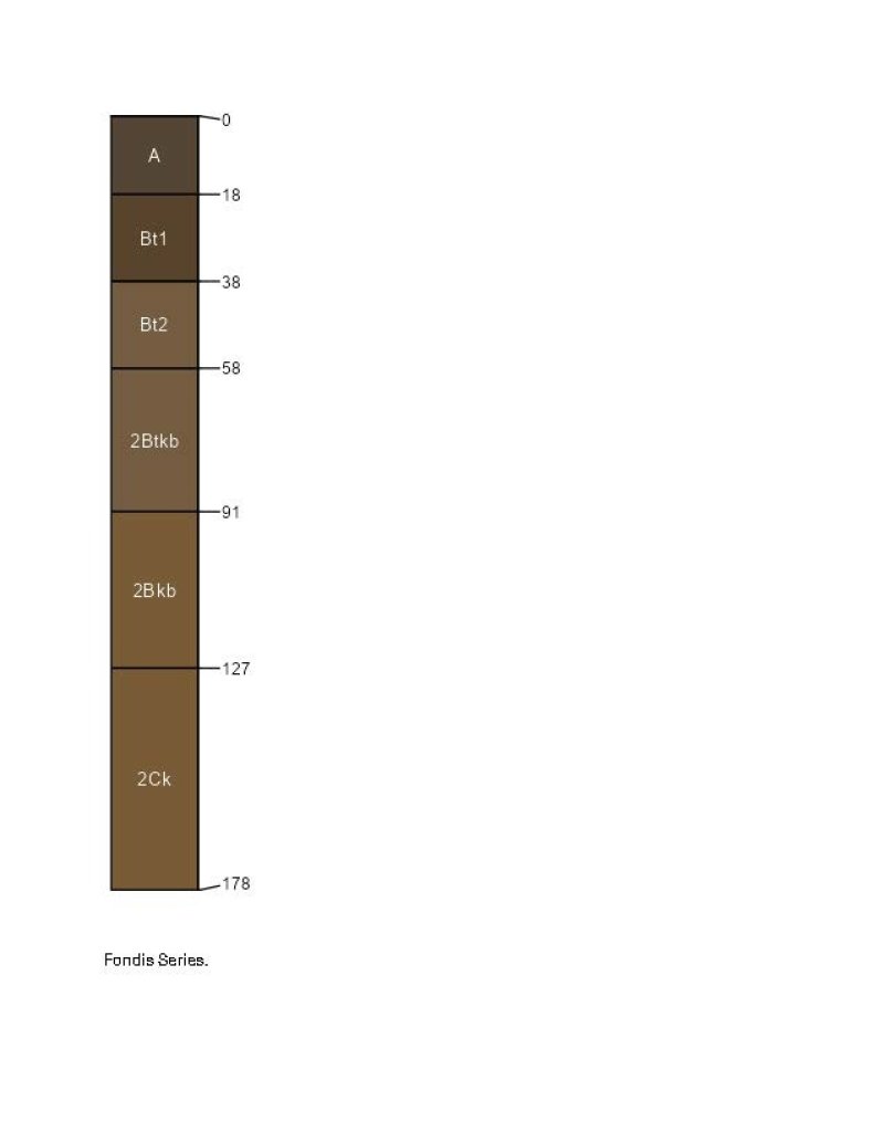
Figure 7.
Table 5. Representative soil features
| Parent material |
(1)
Alluvium
–
shale
(2) Slope alluvium – sedimentary rock (3) Residuum |
|---|---|
| Surface texture |
(1) Gravelly, cobbly clay loam (2) Clay |
| Family particle size |
(1) Fine |
| Drainage class | Well drained |
| Permeability class | Slow to very slow |
| Soil depth | 20 – 60 in |
| Surface fragment cover <=3" | 13% |
| Surface fragment cover >3" | 20% |
| Available water capacity (0-40in) |
4 – 7 in |
| Calcium carbonate equivalent (0-40in) |
15% |
| Electrical conductivity (0-40in) |
8 mmhos/cm |
| Sodium adsorption ratio (0-40in) |
4 |
| Soil reaction (1:1 water) (0-40in) |
6.1 – 9 |
Table 6. Representative soil features (actual values)
| Drainage class | Well drained |
|---|---|
| Permeability class | Slow to very slow |
| Soil depth | 20 – 60 in |
| Surface fragment cover <=3" | 13% |
| Surface fragment cover >3" | 20% |
| Available water capacity (0-40in) |
4 – 7 in |
| Calcium carbonate equivalent (0-40in) |
15% |
| Electrical conductivity (0-40in) |
8 mmhos/cm |
| Sodium adsorption ratio (0-40in) |
4 |
| Soil reaction (1:1 water) (0-40in) |
6.1 – 9 |
Ecological dynamics
The Clayey Foothill ecological site is characterized by four states: Reference, Shortgrass Dominated, Degraded, and Invaded States. Transitions between states and their respective communities are primarily driven by natural disturbance regimes, the most significant being periodic drought, grazing that results in chronic defoliation (both natural and agricultural), and fire. The timing and magnitude of these disturbances affect the various stages of the vegetative communities as described in the state and transition model.
The historical fire frequency of the the Palmer Divide LRU ranges from 6 to 10 years (Guyette, et al). The impact of fire over the past 50 years has been relatively insignificant due to wildfire suppression and the lack of acceptance of prescribed fire as a management tool. Prolonged drought, coupled with fire suppression, has increased the frequency and intensity of periodic wildfires in the area. Dendroecological reconstructions of fire history showed that fires burned during years of extreme drought (2011. Schoennagel, Sherriff, Veblen).
A portion of this ecological site has been fragmented due to tillage, and urban development. State and Transition Model Information: A state and transition Model (STM) diagram for this ecological site is depicted in this section. Thorough descriptions of each state, transition, plant community, and pathway are found after the state and transition model. This STM is based on available experimental research, field observations, professional consensus, and interpretations. While based on the best available information, the STM may change over time as knowledge of ecological processes increases.
State and transition model
More interactive model formats are also available.
View Interactive Models
Click on state and transition labels to scroll to the respective text
Ecosystem states
| R 2A | - | Prescribed Grazing. Prescribed Fire. Range Planting. |
|---|
State 1 submodel, plant communities
| 1.2A | - | Prescribed Grazing. Prescribed Fire. |
|---|---|---|
| 1.3A | - | Prescribed Grazing. Prescribed Fire. Range Seeding. |
State 2 submodel, plant communities
State 3 submodel, plant communities
State 4 submodel, plant communities
State 1
Reference
The Reference State of the Clayey Foothill Palmer Divide ecological site is a dynamic state that contains three vegetative communities. These communities fluctuate within the parameters that define the state. Precipitation patterns and management strategies regarding herbivory and the presence or absence of fire are the primary drivers that determine the distribution of these communities throughout this state (Anderson, et al, 1982).
Characteristics and indicators. Characteristics and indicators. This state has not been sodbusted or overly eroded and has only slight to moderate vegetative deviation from the historical mixed- grass prairie community.
Resilience management. The Reference state can be maintained by managing herbivory with appropriate stocking rates, and timing and duration of grazing periods. Maintaining a natural fire regime with appropriately timed prescribed burning also contributes to the resilience of this state.
Dominant plant species
-
fourwing saltbush (Atriplex canescens), shrub
-
winterfat (Krascheninnikovia lanata), shrub
-
western wheatgrass (Pascopyrum smithii), grass
-
green needlegrass (Nassella viridula), grass
-
blue grama (Bouteloua gracilis), grass
Community 1.1
Western Wheatgrass, Green Needlegrass, Fourwing Saltbush, and Winterfat
This plant community evolved with grazing by large herbivores and is well suited for grazing by domestic livestock as well as many wildlife species. It can be found on areas that are properly managed with prescribed grazing that allows for adequate recovery periods following each grazing event. The potential vegetation is about 70 to 85 percent grasses and grass-like plants, 10 to15 percent forbs and five to 15 percent woody plants. The major grasses include western wheatgrass (Pascopyrum smithii), green needlegrass (Nassella viridula), and blue grama (Bouteloua gracilis). Subdominant grasses include little bluestem (Schizachryium scoparium), and big bluestem (Andropogon gerardii). Minor grasses and grasslikes include mountain muhly (Muhlenbergia montana), and sideoats grama (Bouteloua curtipendula). Major forbs include American vetch (Vicia americana), scarlet globemallow (Sphaeralcea coccinea), and purple prairieclover (Dalea purpurea). Shrubs include winterfat (Krascheninnikovia lanata), and fourwing saltbush (Atriplex canescens). This plant community is diverse, stable, and productive. Litter is uniformly distributed with very little movement off site and natural plant mortality is very low. It is well suited to carbon sequestration, water infiltration, wildlife use by many species, livestock use, and is aesthetically pleasing. Community dynamics, nutrient cycle, water cycle, and energy flow are functioning properly. This community is resistant to many disturbances with the exceptions of excessive herbivory, tillage, and development into urban or other uses. The median annual production is 1,600 pounds per acre (air-dry) during an average precipitation year, but ranges from 700 to 2,000.
Resilience management. This community can be maintained by managing herbivory with appropriate stocking rates, and timing and duration of grazing periods. Maintaining a natural fire regime with appropriately timed prescribed burning also contributes to resilience.
Dominant plant species
-
fourwing saltbush (Atriplex canescens), shrub
-
winterfat (Krascheninnikovia lanata), shrub
-
western wheatgrass (Pascopyrum smithii), grass
-
green needlegrass (Nassella viridula), grass
-
blue grama (Bouteloua gracilis), grass
-
American vetch (Vicia americana), other herbaceous
-
scarlet globemallow (Sphaeralcea coccinea), other herbaceous
Figure 8. Annual production by plant type (representative values) or group (midpoint values)
Table 7. Annual production by plant type
| Plant type | Low (lb/acre) |
Representative value (lb/acre) |
High (lb/acre) |
|---|---|---|---|
| Grass/Grasslike | 470 | 1240 | 1500 |
| Forb | 155 | 200 | 250 |
| Shrub/Vine | 75 | 160 | 250 |
| Total | 700 | 1600 | 2000 |
Figure 9. Plant community growth curve (percent production by month). CO4930, Cool season dominant, warm season sub-dominant; MLRA 49C; upland clayey soils.
| Jan | Feb | Mar | Apr | May | Jun | Jul | Aug | Sep | Oct | Nov | Dec |
|---|---|---|---|---|---|---|---|---|---|---|---|
| J | F | M | A | M | J | J | A | S | O | N | D |
| 5 | 20 | 30 | 25 | 15 | 5 |
Community 1.2
Decadent Western Wheatgrass, Green Needlegrass, Fourwing Saltbush, and Winterfat
This plant community develops as a result of the lack of the natural disturbances of herbivory and fire. Plant species resemble the 1.1 community, but the frequency and production of the dominant grass species are reduced. Eventually, litter levels can become high enough to cause decadence and mortality of dominant grass species. Shrubs like prairie sagewort (Artemisia frigida) often increase. Introduced species may also invade. Much of the nutrients are tied up in excessive litter. The semiarid environment and the absence of animal impact to break down litter slow nutrient recycling. Aboveground litter also limits sunlight from reaching plant crowns. Many plants die off. Thick litter and absence of grazing and fire reduce seed germination and establishment. In advanced stages, plant mortality can increase and erosion may eventually occur if bare ground increases.. Once this happens it will require increased input to bring back. Total annual production varies from 250 to 1200 pounds of air-dry vegetation per acre.
Resilience management. To sustain this community, occasional light disturbance from herbivory or prescribed fire is recommended.
Dominant plant species
-
fourwing saltbush (Atriplex canescens), shrub
-
winterfat (Krascheninnikovia lanata), shrub
-
western wheatgrass (Pascopyrum smithii), grass
-
green needlegrass (Nassella viridula), grass
Figure 10. Plant community growth curve (percent production by month). CO4935, Cool season dominant, warm season sub-dominant, excess litter; MLRA 49D; upland clayey soils.
| Jan | Feb | Mar | Apr | May | Jun | Jul | Aug | Sep | Oct | Nov | Dec |
|---|---|---|---|---|---|---|---|---|---|---|---|
| J | F | M | A | M | J | J | A | S | O | N | D |
| 5 | 20 | 25 | 25 | 20 | 5 |
Community 1.3
At Risk Western Wheatgrass, Blue Grama, and Fourwing Saltbush
This plant community developed under excessive herbivory without providing adequate recovery periods during the growing season. Species such as western wheatgrass, big bluestem, green needlegrass, American vetch, fourwing saltbush, and winterfat have been reduced to remnant amounts. Blue grama has increased, dominates the plant community, and is beginning to take on a sod appearance. Purple threeawn ( Aristida purpurea), sixweeks fescue (Vulpia octofloria), and plains pricklypear (Opuntia polyacantha), have also increased. Total aboveground carbon has been reduced due to decreases in forage and litter production. Reduction of rhizomatous wheatgrass, nitrogen fixing forbs, the shrub component with an increase of warm season short grasses has begun to alter the biotic integrity of this community. Water and nutrient cycles may be impaired. Total annual production averages 900 pounds in a normal year.
Resilience management. Resilience management for this community is to adjust the herbivory impacts through stocking rate, timing, and frequency of the grazing period prior to conversion to a sod-bound state.
Dominant plant species
-
fourwing saltbush (Atriplex canescens), shrub
-
western wheatgrass (Pascopyrum smithii), grass
-
blue grama (Bouteloua gracilis), grass
Figure 11. Plant community growth curve (percent production by month). CO4931, Warm season dominant, cool season sub-dominant; MLRA 49C; upland clayey soils.
| Jan | Feb | Mar | Apr | May | Jun | Jul | Aug | Sep | Oct | Nov | Dec |
|---|---|---|---|---|---|---|---|---|---|---|---|
| J | F | M | A | M | J | J | A | S | O | N | D |
| 10 | 45 | 25 | 15 | 5 |
Pathway 1.1A
Community 1.1 to 1.2
Lack of disturbances such as herbivory, mowing, and fire results in excessive litter, low plant density, and increased plant mortality. These conditions drive this to the Decadent Western Wheatgrass, Green Needlegrass, Winterfat, and Fourwing Saltbush community.
Context dependence. The amount of growing season precipitation affects the rate and degree of this community shift.
Pathway 1.1B
Community 1.1 to 1.3
Excessive herbivory causes a shift to the 1.3 plant community. Reduced fire frequency accelerates this process.
Context dependence. The amount of growing season precipitation affects the rate and degree of this community shift.
Pathway 1.2A
Community 1.2 to 1.1
Prescribed grazing with adequate recovery periods between each grazing event and a proper stocking rate restores this plant community back to the Western Wheatgrass, Green Needlegrass, Winterfat, and Fourwing Saltbush community. Prescribed burning accelerates this process.
Context dependence. Abundant growing season precipitation accelerates this process, while drought slows recovery.
Pathway 1.3A
Community 1.3 to 1.1
Prescribed grazing with adequate recovery periods between each grazing event and a proper stocking rate restores this plant community back to the Western Wheatgrass, Green Needlegrass, Winterfat, and Fourwing Saltbush community. Prescribed burning accelerates this process.
Context dependence. Abundant growing season precipitation accelerates this process, while drought impedes recovery. There must be an adequate remnant vegetative presence to allow recovery.
Conservation practices
| Prescribed Burning | |
|---|---|
| Prescribed Grazing | |
| Range Planting |
State 2
Shortgrass Dominated
The Shortgrass Dominated State consists of one plant community. An ecological threshold has been crossed relative to the Reference State resulting in loss of ecological resilience.
Characteristics and indicators. The dominant plant community in this state has been significantly altered when compared to the dominant plant communities in the Reference state. Blue grama is the primary species, and the majority of the other native grasses and desirable forbs and shrubs are absent or greatly diminished. Erosion is not a major issue in this state.
Resilience management. Moderate herbivory maintains this state.
Dominant plant species
-
prairie sagewort (Artemisia frigida), shrub
-
plains pricklypear (Opuntia polyacantha), shrub
-
blue grama (Bouteloua gracilis), grass
-
buffalograss (Bouteloua dactyloides), grass
Community 2.1
Blue Grama and Buffalograss
This plant community evolved with heavy continuous grazing. Fourwing saltbush, winterfat, American vetch, big bluestem, and green needlegrass have been removed. Western wheatgrass may persist in trace amounts, greatly reduced in vigor and not readily seen. Blue grama dominates the community with a tight “sodbound” structure. Buffalograss Bouteloua dactyloides), plains pricklypear (Opuntia polyacantha), fringed sagebrush, Fendler's threeawn, (Aristida purpurea var. fendleriana), and other less palatable species have increased.
Resilience management. Light to moderate grazing will maintain this community.
Dominant plant species
-
plains pricklypear (Opuntia polyacantha), shrub
-
prairie sagewort (Artemisia frigida), shrub
-
blue grama (Bouteloua gracilis), grass
-
buffalograss (Bouteloua dactyloides), grass
-
Fendler's threeawn (Aristida purpurea var. fendleriana), grass
Figure 12. Plant community growth curve (percent production by month). CO4922, Blue Grama Sod, MLRA 49. Warm season dominant, shortgrass, MLRA 49.
| Jan | Feb | Mar | Apr | May | Jun | Jul | Aug | Sep | Oct | Nov | Dec |
|---|---|---|---|---|---|---|---|---|---|---|---|
| J | F | M | A | M | J | J | A | S | O | N | D |
| 2 | 12 | 30 | 35 | 18 | 3 |
State 3
Degraded
The Plains Pricklypear, Prairie Sagewort, Sleepygrass, and Fendler's Threeawn community characterizes this state. An ecological threshold has been crossed resulting in complete loss of resilience and resistance to disturbance.
Characteristics and indicators. Increase in the amount of bare ground is readily distinguishable. Plant community structure appears as patch areas of sleepygrass, Fendler's threeawn, and annuals with scattered shrubs such as prairie sagewort and plains pricklypear. Remnant patches of blue grama may be present.
Resilience management. Light to moderate grazing maintains this state.
Dominant plant species
-
plains pricklypear (Opuntia polyacantha), shrub
-
broom snakeweed (Gutierrezia sarothrae), shrub
-
prairie sagewort (Artemisia frigida), shrub
-
sleepygrass (Achnatherum robustum), grass
-
sixweeks fescue (Vulpia octoflora), grass
-
Fendler's threeawn (Aristida purpurea var. fendleriana), grass
Community 3.1
Plains Pricklypear, Prairie Sagewort, Sleepygrass, and Fendler's Threeawn
This plant community develops through excessive, season-long herbivory. This is especially prevalent on small acreage properties and areas occupied by prairie dog towns. Blue grama may persist in small amounts. Introduced species such as spotted knapweed (Centaurea stoebe ssp. Micranthos), cheatgrass (Bromus tectorum), and Russian thistle (Salsola) are present. Litter levels are extremely low. Erosion is evident where flow paths are continuous. Rills may occur on steeper slopes. Wind scoured areas may be apparent on knolls or unprotected areas. The nutrient cycle, water cycle, and overall energy flow are greatly impaired. Organic matter and carbon reserves are greatly reduced. This community is not stable. Desertification is obvious. Litter levels are extremely low. Erosion is evident where flow paths are continuous. Rills may occur on steeper slopes. Wind scoured areas may be apparent on knolls or unprotected areas.
Resilience management. The nutrient cycle, water cycle, and overall energy flow are greatly impaired. Erosion is a major concern. Organic matter and carbon reserves are greatly reduced. This community is not stable and desertification is obvious.
Dominant plant species
-
prairie sagewort (Artemisia frigida), shrub
-
broom snakeweed (Gutierrezia sarothrae), shrub
-
plains pricklypear (Opuntia polyacantha), shrub
-
sleepygrass (Achnatherum robustum), grass
-
sixweeks fescue (Vulpia octoflora), grass
-
Fendler threeawn (Aristida purpurea var. longiseta), grass
-
Russian thistle (Salsola), other herbaceous
-
spotted knapweed (Centaurea stoebe), other herbaceous
Figure 13. Plant community growth curve (percent production by month). CO4923, Snakeweed, Pioneer Annual/Perennials, Bare Ground; MLRA 49. Warm/cool season, annual/perennial forbs.
| Jan | Feb | Mar | Apr | May | Jun | Jul | Aug | Sep | Oct | Nov | Dec |
|---|---|---|---|---|---|---|---|---|---|---|---|
| J | F | M | A | M | J | J | A | S | O | N | D |
| 5 | 10 | 20 | 25 | 30 | 10 |
State 4
Invaded
An ecological threshold has been crossed as shown by a complete loss of biologic integrity and impaired hydrologic function. Invasive plants have largely replaced the desirable native species.
Characteristics and indicators. Distinguishing characteristics are the dominance of invasive species such as spotted knapweed (Centaurea stoebe), cheatgrass Bromus tectorum), and Russian thistle (Salsola). Native grasses, forbs, and shrubs can be present in varying amounts depending on the severity of invasion.
Resilience management. This state is not stable and desertification is well advanced. The community is lacking ecological resilience and resistance. Wind and water erosion are concerns.
Dominant plant species
-
plains pricklypear (Opuntia polyacantha), shrub
-
broom snakeweed (Gutierrezia sarothrae), shrub
-
cheatgrass (Bromus tectorum), grass
-
sleepygrass (Achnatherum robustum), grass
-
Russian thistle (Salsola), other herbaceous
-
spotted knapweed (Centaurea stoebe), other herbaceous
-
bastard toadflax (Comandra), other herbaceous
Community 4.1
Cheatgrass, Sleepygrass, and Russian Thistle
Invasive plants develop as a result of excessive herbivory or domestic disturbance that can result from the heavy subdivision pressure along the front range. The community is dominated by plants such as knapweeds (centuria), cheatgrass, and Russian thistle.
Resilience management. This plant community is not stable and desertification is well advanced. The community is lacking ecological resilience and resistance. Wind and water erosion are concerns.
Dominant plant species
-
plains pricklypear (Opuntia polyacantha), shrub
-
broom snakeweed (Gutierrezia sarothrae), shrub
-
cheatgrass (Bromus tectorum), grass
-
sleepygrass (Achnatherum robustum), grass
-
blue grama (Bouteloua gracilis), grass
Figure 14. Plant community growth curve (percent production by month). CO4933, Introduced dominant; MLRA-49C; upland clayey soils.
| Jan | Feb | Mar | Apr | May | Jun | Jul | Aug | Sep | Oct | Nov | Dec |
|---|---|---|---|---|---|---|---|---|---|---|---|
| J | F | M | A | M | J | J | A | S | O | N | D |
| 3 | 20 | 45 | 20 | 10 | 2 |
Transition T1A
State 1 to 2
Continuous vegetative defoliation without adequate recovery periods. Interruption of the natural fire regime.
Constraints to recovery. Lack of adequate growing season precipitation accelerates this transition.
Context dependence. Fluctuations in local growing season precipitation patterns can significantly affect the response of the local vegetative community.
Restoration pathway R 2A
State 2 to 1
Long term prescribed grazing with adequate recovery periods coupled with appropriate stocking enables restoration to the Reference state. Appropriately timed prescribed fire supports this restoration.
Context dependence. The local growing season precipitation patterns greatly influence the success of the recovery effort. If restoration from remnant native vegetation isn't feasible, re- introduction of the desired species may be required.
Conservation practices
| Prescribed Burning | |
|---|---|
| Prescribed Grazing | |
| Range Planting |
Transition T2A
State 2 to 3
Continuous defoliation without adequate recovery periods and interruption of the natural fire regime.
Constraints to recovery. Lack of adequate growing season precipitation. Lack of seed source.
Context dependence. Fluctuations in local growing season precipitation patterns significantly affect the response of the local vegetative community.
Additional community tables
Table 8. Community 1.1 plant community composition
| Group | Common name | Symbol | Scientific name | Annual production (lb/acre) | Foliar cover (%) | |
|---|---|---|---|---|---|---|
|
Grass/Grasslike
|
||||||
| 1 | Grasses & Grass-likes | 1120–1360 | ||||
| western wheatgrass | PASM | Pascopyrum smithii | 320–480 | – | ||
| green needlegrass | NAVI4 | Nassella viridula | 240–320 | – | ||
| blue grama | BOGR2 | Bouteloua gracilis | 160–240 | – | ||
| big bluestem | ANGE | Andropogon gerardii | 30–110 | – | ||
| little bluestem | SCSC | Schizachyrium scoparium | 15–80 | – | ||
| mountain muhly | MUMO | Muhlenbergia montana | 15–80 | – | ||
| sideoats grama | BOCU | Bouteloua curtipendula | 15–80 | – | ||
| Montana wheatgrass | ELAL7 | Elymus albicans | 15–50 | – | ||
| Sandberg bluegrass | POSE | Poa secunda | 15–50 | – | ||
| buffalograss | BODA2 | Bouteloua dactyloides | 15–50 | – | ||
| Grass, native | 2GN | Grass, native | 0–50 | – | ||
| muttongrass | POFE | Poa fendleriana | 15–30 | – | ||
| Canada wildrye | ELCA4 | Elymus canadensis | 15–30 | – | ||
| prairie Junegrass | KOMA | Koeleria macrantha | 15–30 | – | ||
| switchgrass | PAVI2 | Panicum virgatum | 0–30 | – | ||
| sun sedge | CAINH2 | Carex inops ssp. heliophila | 15–30 | – | ||
| Geyer's sedge | CAGE2 | Carex geyeri | 15–30 | – | ||
| prairie sandreed | CALO | Calamovilfa longifolia | 0–15 | – | ||
| Indian ricegrass | ACHY | Achnatherum hymenoides | 0–15 | – | ||
| squirreltail | ELEL5 | Elymus elymoides | 0–15 | – | ||
| sand dropseed | SPCR | Sporobolus cryptandrus | 0–15 | – | ||
| Fendler threeawn | ARPUL | Aristida purpurea var. longiseta | 0–15 | – | ||
| slender wheatgrass | ELTR7 | Elymus trachycaulus | 0–15 | – | ||
| sixweeks fescue | VUOC | Vulpia octoflora | 0–15 | – | ||
|
Forb
|
||||||
| 2 | Forbs | 160–240 | ||||
| Forb, native | 2FN | Forb, native | 30–80 | – | ||
| purple prairie clover | DAPUP | Dalea purpurea var. purpurea | 30–65 | – | ||
| American vetch | VIAM | Vicia americana | 30–65 | – | ||
| scarlet globemallow | SPCO | Sphaeralcea coccinea | 30–50 | – | ||
| upright prairie coneflower | RACO3 | Ratibida columnifera | 15–50 | – | ||
| Drummond's milkvetch | ASDR3 | Astragalus drummondii | 15–30 | – | ||
| slimflower scurfpea | PSTE5 | Psoralidium tenuiflorum | 15–30 | – | ||
| prairie spiderwort | TROC | Tradescantia occidentalis | 15–30 | – | ||
| dotted blazing star | LIPU | Liatris punctata | 15–30 | – | ||
| white sagebrush | ARLUA | Artemisia ludoviciana ssp. albula | 15–30 | – | ||
| foothill arnica | ARFU3 | Arnica fulgens | 15–30 | – | ||
| Cuman ragweed | AMPS | Ambrosia psilostachya | 15–30 | – | ||
| lacy tansyaster | MAPIP | Machaeranthera pinnatifida ssp. pinnatifida | 0–15 | – | ||
| twogrooved milkvetch | ASBI2 | Astragalus bisulcatus | 0–15 | – | ||
| bastard toadflax | COUM | Comandra umbellata | 0–15 | – | ||
| silvery lupine | LUAR3 | Lupinus argenteus | 0–15 | – | ||
| hairy false goldenaster | HEVI4 | Heterotheca villosa | 0–15 | – | ||
| tarragon | ARDR4 | Artemisia dracunculus | 0–15 | – | ||
| rosy pussytoes | ANRO2 | Antennaria rosea | 0–15 | – | ||
| textile onion | ALTE | Allium textile | 0–15 | – | ||
| red dome blanketflower | GAPI | Gaillardia pinnatifida | 0–15 | – | ||
| threadleaf ragwort | SEFLF | Senecio flaccidus var. flaccidus | 0–15 | – | ||
|
Shrub/Vine
|
||||||
| 3 | Shrubs | 80–240 | ||||
| fourwing saltbush | ATCA2 | Atriplex canescens | 80–190 | – | ||
| winterfat | KRLA2 | Krascheninnikovia lanata | 30–110 | – | ||
| prairie rose | ROAR3 | Rosa arkansana | 15–30 | – | ||
| rubber rabbitbrush | ERNAN5 | Ericameria nauseosa ssp. nauseosa var. nauseosa | 15–30 | – | ||
| prairie sagewort | ARFR4 | Artemisia frigida | 15–30 | – | ||
| Shrub, other | 2S | Shrub, other | 15–30 | – | ||
| western snowberry | SYOC | Symphoricarpos occidentalis | 0–15 | – | ||
| broom snakeweed | GUSA2 | Gutierrezia sarothrae | 0–15 | – | ||
| plains pricklypear | OPPO | Opuntia polyacantha | 0–15 | – | ||
| soapweed yucca | YUGL | Yucca glauca | 0–15 | – | ||
Interpretations
Animal community
1.1 Community:
Common bird species expected on these communities include Cassin’s sparrow, chestnut collared longspur, lark bunting, mountain bluebird, western meadowlark, and ferruginous and Swainson’s hawks. White-tailed and black-tailed jackrabbit, badger, pronghorn, coyote, swift fox, plains pocket gopher, long-tailed weasel, elk, mountain lion, mule deer, black bear, and several species of mice are mammals that commonly use these plant communities. Reptiles using these communities include western rattlesnake, bullsnake, plains garter snake (if water is in home range), western hognose snake, racer, western box turtle, and six-lined racerunner. Many of these species may disappear due to habitat fragmentation from subdivision and small acreage development.
1.2 Community:
The reduction of shrubs and taller grasses in this plant community results in a shift of bird species away from the reference community birds. Lark bunting, chestnut-collared longspur, and western meadowlark use declines and Cassin’s sparrow stop using the community altogether. Habitat conditions are ideal for long-billed curlew. McCown’s longspur, burrowing owl, mountain plover, killdeer, and horned lark begin using this community. Ferruginous and Swainson’s hawks are also frequent users of this community.
Most mammals will be the same as in the reference community, however jackrabbit, black-tailed prairie dog, desert cottontail, and thirteen-lined ground squirrel use increases due to better adaptation. Reptiles using this community are the same as in the 1.1 community. Many of these species may disappear due to habitat fragmentation from subdivision and small acreage development.
All other communities:
Burrowing owl, mountain plover, horned lark, McCown’s longspur, killdeer, and long-billed curlew use these plant communities. With the exception of the hawk species, no 1.1 community bird species frequents these communities. Jackrabbit, black-tailed prairie dog, thirteen-lined ground squirrel, and desert cottontail rabbit are frequent users of these communities. All other mammal species from the1.1 community may use the community. Reptiles using these communities exclusively are short-horned lizard and lesser earless lizard. Other reptiles using these communities include the species listed for the 1.1 community. Many of these species may disappear due to habitat fragmentation from subdivision and small acreage development.
Other Potential Species
The plains spadefoot is the only common species of frog or toad inhabiting grasslands in Eastern Colorado. This species requires water for breeding. Tiger salamanders may be found on grassland sites, but require a water body for breeding. Either of these species may be found in any plant community if seasonal water requirements are met. Mule and white-tailed deer may use this ecological site, however the shrub cover is too low to expect more than occasional use. Big brown bats use all plant communities on this ecological site if a building site is in the area. The gray wolf, black-footed ferret, and wild bison used this ecological site in historic times. The wolf and ferret are thought to be extirpated from Eastern Colorado. Bison are currently found only as domestic livestock.
Animal Community – Grazing Interpretations
The following table lists suggested initial stocking rates for cattle under continuous grazing (year long grazing or growing season long grazing) under normal growing conditions however, continuous grazing is not recommended. These are conservative estimates that should be used only as guidelines in the initial stages of the conservation planning process. Often, the current plant composition does not entirely match any particular plant community (described in this ecological site description). Because of this, a field visit is recommended, in all cases, to document plant composition and production. More precise carrying capacity estimates should eventually be calculated using the following stocking rate information along with animal preference data, particularly when grazers other than cattle are involved. Under more intensive grazing management, improved harvest efficiencies can result in an increased carrying capacity.
Plant Community (PC); Production (lbs. per acre); Stocking Rate (AUM/acre)
1.1 PC; 1600; 0.44
1.2 PC; 900; 0.25
1.3 PC; 650; 0.18
Small acreage hobby ranching (primarily horse grazing) is the major use of rangeland in the western portion of this area. Overstocking is prevalent on small acreages, resulting in invasion by weeds. In the eastern portion of this area grazing by cattle is still the major use of rangeland. Rangeland throughout the area may provide forage for cattle, horses, and other herbivores if it is properly stocked and combined with prescribed grazing that allows adequate recovery periods following each grazing event.
Hydrological functions
Water is the principal factor limiting forage production on this site. Infiltration and runoff potential for this site varies from moderate to high depending on soil hydrologic group and ground cover. In many cases, areas with greater than 75 percent ground cover have the greatest potential for high infiltration and lower runoff. Areas where ground cover is less than 50 percent have the greatest potential to have reduced infiltration and higher runoff (refer to NRCS Section 4, National Engineering Handbook (NEH-4) for runoff quantities and hydrologic curves).
Recreational uses
This site provides hiking, photography, bird watching, mountain biking, hunting (in less urbanized areas) and other opportunities. The wide varieties of plants that bloom from spring until fall have an aesthetic value that appeals to visitors.
Wood products
No appreciable wood products are present on the site.
Supporting information
Inventory data references
A minimum of 20 low or medium intensity observations are required to meet verification level status. This ESD is citing NRI and 417 data to meet these minimums. Individual observations are listed in EDIT and are viewable behind the login. A corresponding tracking sheet is available in the MLRA office that links the list to the actual observations used in analysis.
References
-
Anderson, R.C. 1982. An evolutionary model summarizing the roles of fire, climate, and grazing animals in the origin and maintenance of grasslands. Pages 297–308 in , , and , editors. Grasses and grasslands: systematics and ecology.
-
Schoennagel, T., D.M. Waller, M.G. Turner, and W.H. Romme. 2004. The effect of fire interval on post-fire understorey communities in Yellowstone National Park. Journal of Vegetation Science 15:797–806.
-
Schoennagel, T., R.L. Sherriff, and T.T. Veblen. 2011. Fire history and tree recruitment in the Colorado Front Range upper montane zone: implications for forest restoration. Ecological Applications 21:2210–2222.
Other references
Abella, Scott R., 2008. Managing Gambel Oak in southwestern ponderosa pine forests: The status of our knowledge. Faculty Publications (SEPA). Paper 349.University of Nevada, Las Vegas
Allen, Robert B., Robert K. Peet and William L. Baker., 1991. Gradient analysis of latitudinal variation in southern Rocky Mountain forests. Journal of Biogeography 18, 123-139
Banzhaf, William H., et al., 1986. Gambel Oak in Colorados Front Range. Potentials of noncommercial forest biomass for energy. Excerpt from Univ. of Ariz. School of Renewable Natural Resources. Technical Bulletin No. 256
Colorado Climate Center. 2010. Monthly Data. Data Access. http://ccc.atmos.colostate.edu/dataaccess.php
Ecological Society of America, 2011. Ecological Applications, 21(6), pp. 2210–2222.
Fitzgerald, J. P., Meaney, C. A., and Armstrong, D. M. 1994. Denver Museum of Natural History and University Press of Colorado. Mammals of Colorado
Guyette, Richard P., M. C. Stambaugh, D. C. Dey, RM Muzika. 2012. Predicting fire frequency with chemistry and climate. Ecosystems, 15: 322-335.
Hammerson, G. A. 1999. University Press of Colorado. Amphibians and Reptiles in Colorado A Colorado Field Guide
Jackson, Donald., 1966 The journals of Zebulon Montgomery Pike with letters & related documents. Univ. of Oklahoma Press, First Edition
Kingery, H. E. 1998. Colorado Breeding Bird Atlas, Colorado Bird Atlas Partnership and Colorado Division of Wildlife
NOAA Western Regional Climate Center, 2215 Raggio Parkway Reno, NV 89512 (http://www.wrcc.dri.edu)
Peet, Robert K., 1978. Forest vegetation of the Colorado Front Range; Patterns of species diversity. Vegetatio Vol. 37, 2: 65-78
Richardson., 1915. G.B. Geologic atlas of the United States, Castle Rock Folio. U.S. Geologic Survey
Soil Survey Staff, USDA-NRCS Official Soil Series Descriptions. Available online at http://soils.usda.gov/technical/classification/osd/index.html. Accessed [April 3, 2013].
Soil Survey Staff, USDA-NRCS U.S. General Soil Map (STATSGO2). Available online at http://soildatamart.nrcs.usda.gov. Accessed [April 3, 2013].
USDA, NRCS. Grazing Lands Technology Institute, Revision 1, December 2003, issued September 1997. National Range and Pasture Handbook at http://www.co.nrcs.usda.gov/ Home / Land Use / Range & Pasture / National Range and Pasture Handbook.
USDA, NRCS. National Soil Information System, Information Technology Center, 2150 Centre Avenue, Building A, Fort Collins, CO 80526. http://nasis.nrcs.usda.gov
USDA, NRCS. 2013. The PLANTS Database (http://plants.usda.gov, 6 September 2013). National Plant Data Team, Greensboro, NC 27401-4901 USA.
USDA-Soil Conservation Service (SCS). Soil Survey of Arapahoe County, Colorado. Issued 1971 in cooperation with Colorado Agricultural Experiment Station. US Government Printing Office
USDA-SCS. Soil Survey of Castle Rock Area, Colorado. Issued 1974 in cooperation with Colorado Agricultural Experiment Station. US Government Printing Office
USDA-SCS. Soil Survey of Elbert County, Colorado, Western Part. Issued 1979 in cooperation with Colorado Agricultural Experiment Station. US Government Printing Office
USDA-SCS. Soil Survey of El Paso County Area, Colorado. Issued 1980 in cooperation with Colorado Agricultural Experiment Station. US Government Printing Office
USDA-NRCS Agriculture Handbook 296, issued 2006. Land Resource Regions and Major Land Resource Areas of the United States, the Caribbean, and the Pacific Basin
NOAA Western Regional Climate Center, 2215 Raggio Parkway, Reno, NV 89512 (http://www.wrcc.dri.edu)
Soil Survey Staff, USDA-NRCS Official Soil Series Descriptions. Available online at http://soils.usda.gov/technical/classification/osd/index.html. Accessed [April 3, 2013].
Soil Survey Staff, USDA-NRCS U.S. General Soil Map (STATSGO2). Available online at http://soildatamart.nrcs.usda.gov. Accessed [April 3, 2013].
Tania Schoennagel, Rosemary L. Sherrif, and Thomas T. Veblin. Fire history and tree recruitment in the Colorado Front Range upper montane zone: implications for forest restoration
USDA, NRCS. National Range and Pasture Handbook, September 1997
USDA, NRCS. National Soil Information System, Information Technology Center, 2150 Centre Avenue, Building A, Fort Collins, CO 80526. (http://nasis.nrcs.usda.gov)
USDA, NRCS. 2013. The PLANTS Database (http://plants.usda.gov, 6 September 2013). National Plant Data Team, Greensboro, NC 27401-4901 USA.
Contributors
D.A. Nosal,
H.A. Sprock,
B.P. Berlinger,
K.A. Diller,
Lee A. Neve,
Revised by Doug Whisenhunt
Approval
Kirt Walstad, 5/08/2025
Rangeland health reference sheet
Interpreting Indicators of Rangeland Health is a qualitative assessment protocol used to determine ecosystem condition based on benchmark characteristics described in the Reference Sheet. A suite of 17 (or more) indicators are typically considered in an assessment. The ecological site(s) representative of an assessment location must be known prior to applying the protocol and must be verified based on soils and climate. Current plant community cannot be used to identify the ecological site.
| Author(s)/participant(s) |
Ben P. Berlinger Kimberly A. Diller Dan A. Nosal |
|---|---|
| Contact for lead author | ben.berlinger@co.usda.gov |
| Date | 12/27/2018 |
| Approved by | Kirt Walstad |
| Approval date | |
| Composition (Indicators 10 and 12) based on | Annual Production |
Indicators
-
Number and extent of rills:
None. -
Presence of water flow patterns:
Typically none. If present, short and disconnected. -
Number and height of erosional pedestals or terracettes:
None. -
Bare ground from Ecological Site Description or other studies (rock, litter, lichen, moss, plant canopy are not bare ground):
Two to five percent bare ground, with bare patches generally less than three to five inches in diameter. Extended drought can cause bare ground to increase to five to15 percent, with bare patches of six to12 inches in diameter. -
Number of gullies and erosion associated with gullies:
None. -
Extent of wind scoured, blowouts and/or depositional areas:
None. -
Amount of litter movement (describe size and distance expected to travel):
Minimal and short -
Soil surface (top few mm) resistance to erosion (stability values are averages - most sites will show a range of values):
Soils stability class rating anticipated to be five to six in the interspaces at soil surface. Soil surface is stabilized by decomposing organic matter. Biological crusts (lichens, algae, cyanobacteria, mosses) may be present on or just below soil surface. -
Soil surface structure and SOM content (include type of structure and A-horizon color and thickness):
A-horizon depth is zero to six inches and has a grayish brown to dark gray color. Surface texture is clay loam. Strong fine and medium granular structure or strong fine subangular blocky structure. -
Effect of community phase composition (relative proportion of different functional groups) and spatial distribution on infiltration and runoff:
Cover from sod forming grasses, bunchgrasses, forbs, and shrubs reduce bare ground. Raindrop impact is reduced as well as overland flow, providing increased time for infiltration to occur. Dense stands of blue grama can limit infiltration due to high root densities. Extended drought may reduce short and mid-statured bunchgrass basal cover resulting in decreased infiltration and increased runoff following intense storms. -
Presence and thickness of compaction layer (usually none; describe soil profile features which may be mistaken for compaction on this site):
None. -
Functional/Structural Groups (list in order of descending dominance by above-ground annual-production or live foliar cover using symbols: >>, >, = to indicate much greater than, greater than, and equal to):
Dominant:
Dominant: cool season mid rhizomatous >Sub-dominant:
Sub-dominant:
Cool season mid bunchgrassOther:
Warm season short bunchgrass>shrubs> leguminous forbs,>warm season mid bunchgrass>other forbsAdditional:
Biological Crust: T (based on cover not composition by weight). -
Amount of plant mortality and decadence (include which functional groups are expected to show mortality or decadence):
Typically minimal. Expect slightly more bunchgrass mortality during and following drought. Lack of disturbance will increase occurrence of decadence. -
Average percent litter cover (%) and depth ( in):
The average litter cover is 25 to 40 percent at the 0.25 inch depth. Litter cover during and following extended drought ranges from 15 to 25 percent. -
Expected annual annual-production (this is TOTAL above-ground annual-production, not just forage annual-production):
700 pounds per acre in low precipitation years; 1,600 pounds per acre in average precipitation years; 2,000 pounds per acre in above average precipitation years. After extended drought or the first growing season following wildfire, above ground production may be significantly reduced by 200-300 pounds per acre or more. -
Potential invasive (including noxious) species (native and non-native). List species which BOTH characterize degraded states and have the potential to become a dominant or co-dominant species on the ecological site if their future establishment and growth is not actively controlled by management interventions. Species that become dominant for only one to several years (e.g., short-term response to drought or wildfire) are not invasive plants. Note that unlike other indicators, we are describing what is NOT expected in the reference state for the ecological site:
Invasive plants should not occur in reference plant community. Annuals may temporarily occupy the site following extended fire or drought if a seed source is available. -
Perennial plant reproductive capability:
The only limitations are weather-related, wildfire, natural disease, and insects that may temporarily reduce reproductive capability.
Print Options
Sections
Font
Other
The Ecosystem Dynamics Interpretive Tool is an information system framework developed by the USDA-ARS Jornada Experimental Range, USDA Natural Resources Conservation Service, and New Mexico State University.
Click on box and path labels to scroll to the respective text.
Ecosystem states
| R 2A | - | Prescribed Grazing. Prescribed Fire. Range Planting. |
|---|
State 1 submodel, plant communities
| 1.2A | - | Prescribed Grazing. Prescribed Fire. |
|---|---|---|
| 1.3A | - | Prescribed Grazing. Prescribed Fire. Range Seeding. |