
Natural Resources
Conservation Service
Ecological site F043AY574ID
Ashy Hills and Mountains 30-45" PZ Frigid Western Bitterroot Foothills
Last updated: 5/05/2025
Accessed: 05/19/2025
General information
Provisional. A provisional ecological site description has undergone quality control and quality assurance review. It contains a working state and transition model and enough information to identify the ecological site.
MLRA notes
Major Land Resource Area (MLRA): 043A–Northern Rocky Mountains
This area is mainly in the Northern Rocky Mountains province of the Rocky Mountain System; a small part is in the Walla Walla Plateau section of the Columbia Plateaus province of the Intermontane Plateaus. Elevation is about 1,800 to 3,500 feet (550 to 1,065 meters) in the valleys and about 5,000 to 7,000 feet (1,525 to 2,135 meters) in the mountains. Steep-gradient rivers have cut deep canyons, and natural and manmade lakes are common in the area. Numerous rivers originate in or flow through this area, including, from west to east: the Sanpoil, Columbia, Pend Oreille, Kootenai, St. Joe, Thompson, and Flathead Rivers.
The bedrock formations in MLRA 43A range from Precambrian to Cretaceous in age. They consist of shale, sandstone, siltstone, limestone, argillite, quartzite, gneiss, schist, dolomite, basalt, and granite. Pleistocene glaciers carved a rugged landscape and filled valleys with till and outwash. Parts of the area are covered in varying thicknesses of late-Quaternary loess, silt and fine sand particles transported via wind, as well as Holocene-aged volcanic ash (McDaniel and Hipple 2010).
The average annual precipitation is 25 to 60 inches (635 to 1,525 millimeters) in most of this area, but it is as much as 111 inches (2,820 millimeters) in the mountains and as little as 10 to 15 inches (255 to 380 millimeters) in the western part. The average annual temperature is 32 to 51 degrees F (0 to 11 degrees C) in most of the area, decreasing with increasing elevation. In most of the area, the freeze-free period averages 133 days and ranges from 50 to 215 days. It is longest in the low valleys of Washington and decreases in length at higher elevations. Freezing temperatures occur every month of the year on high mountains, and some peaks have a continuous cover of snow and ice.
Full descriptions of MLRAs can be found in: United States Department of Agriculture, Natural Resources Conservation Service. 2006. Land Resource Regions and Major Land Resource Areas of the United States, the Caribbean, and the Pacific Basin. U.S. Department of Agriculture Handbook 296.
Available electronically at: https://www.nrcs.usda.gov/resources/data-and-reports/major-land-resource-area-mlra
LRU notes
The Ashy Hills and Mountains 30-45” PZ Frigid Ecological Site most commonly occurs in Land Resource Unit (LRU) 09 (Western Bitterroot Foothills) and in areas of LRU 10 (Clearwater Mountains). The Western Bitterroot Foothills LRU lies south of the limit of continental glaciation in the Spokane-Pend Oreille Valleys, and north of the Clearwater-Lochsa River system. This region consists of hills or low mountain slopes, generally under 1,100 meters (3,600 feet) in elevation, that are mantled by volcanic ash and loess. These rich, forest-type soils support species such as grand fir, western redcedar, Douglas-fir, and ponderosa pine. Due to the gentler terrain, productive forests in this region are commonly logged. Less productive sites provide ecosystem services such as wildlife habitat, aesthetic value, and contribute to watershed health.
Classification relationships
MLRA 43A is located within the Rocky Mountain Range and Forest Region. MLRA 43A is divided into eleven Land Resource Units (LRUs) defined by differences in geology, climate, and topography. Each LRU is divided into ten climatic subsets, which differentiate sites on dominant temperature and precipitation zones. The Ashy Hills and Mountains 30-45” PZ Frigid Ecological Site is in LRU Subset F and is defined by a relative effective precipitation ranging from 30 to 45 inches and a frigid soil temperature regime.
The Ashy Hills and Mountains 30-45” PZ Frigid Ecological Site is related to other established vegetation community classifications:
United States National Vegetation Classification (2008), A3612 Western Hemlock – Western Redcedar Cool-Mesic Central Rocky Mountain Forest & Woodland Alliance.
Washington Natural Heritage Program. Ecosystems of Washington State, A Guide to Identification, Rocchio and Crawford, 2015 - Northern Rocky Mt. Mesic Montane Mixed Conifer Forest (Cedar-Hemlock)
Description of Ecoregions of the United States, USFS PN # 1391, 1995 - M333 Northern Rocky Mt. Forest-Steppe- Coniferous Forest-Alpine Meadow Province
Level III and IV Ecoregions of WA, US EPA, June 2010 – 15y Selkirk Mountains, 15w Western Selkirk Maritime Forest.
In addition, this ecological site includes communities related to the following USDA Forest Service Plant Associations Western Redcedar Series: THPL/CLUN, THPL/ASCA (Cooper et al., 1991).
Ecological site concept
The Ashy Hills and Mountains Ecological Site occurs in areas influenced by moist and mild air masses from the Pacific. It occurs on positions within the landscape that accumulate runoff moisture, such as concavities on mountain and hill slopes. The soils developed in thick volcanic ash deposits and have a well-drained drainage class.
Associated sites
| F043AY566ID |
Dry Ashy Hills and Mountains 30-45" PZ Frigid Clearwater Mountains Occurs adjacent to Ashy Hills and Mountains site on convex landscape positions with higher runoff and lower relative effective precipitation. |
|---|---|
| F043AY577ID |
Ashy Depressions 30-45" PZ Frigid Clearwater Mountains Occurs on similar landscapes to Ashy Hills and Mountains site. Typically occupies more concave positions that accumulate runoff moisture and have higher effective precipitation. |
Similar sites
| F043AY575ID |
Vitrandic Hills and Mountains 30-45" PZ Frigid Western Bitterroot Foothills Occurs on similar landscape positions to Ashy Hills and Mountains on soils developed in thin volcanic ash deposits and belonging to Vitrandic soil taxonomic subgroups. |
|---|---|
| F043AY563ID |
Ashy Metasedimentary Mountains 30-45" PZ Frigid Bitterroot Metasedimentary Zone Occurs on similar landscape positions and has similar climate to Ashy Hills and Mountains site. Primary difference is soils developed on metasedimentary materials. |
Table 1. Dominant plant species
| Tree |
(1) Thuja plicata |
|---|---|
| Shrub |
(1) Symphoricarpos albus |
| Herbaceous |
(1) Clintonia uniflora |
Physiographic features
The Ashy Hills and Mountains Ecological site occurs on mountain and foothill slopes at mid-elevations. It primarily exists on moderate slopes. Aspect becomes an important factor at the edges of the site’s elevation range. On the lower end of the elevation range, this site tends to occupy northern aspects. On the higher end, this site occupies southern aspects.
Table 2. Representative physiographic features
| Landforms |
(1)
Mountains
> Mountain slope
(2) Foothills > Hillslope (3) Valley > Stream terrace (4) Valley > Valley floor |
|---|---|
| Flooding frequency | None |
| Ponding frequency | None |
| Elevation | 3,090 – 3,609 ft |
| Slope | 20 – 40% |
| Water table depth | 80 in |
| Aspect | Aspect is not a significant factor |
Table 3. Representative physiographic features (actual ranges)
| Flooding frequency | None |
|---|---|
| Ponding frequency | None |
| Elevation | 1,640 – 4,780 ft |
| Slope | 3 – 65% |
| Water table depth | 14 – 80 in |
Climatic features
The climate at this site is influenced by the dominant wind patterns of the Pacific Northwest. Winds blowing from the west bring airmasses from the Pacific Ocean into the Rocky Mountain region. This maritime influence results in a humid environment where the majority of precipitation falls as light, steady rain throughout the fall, winter, and spring months. At higher elevations the precipitation falls as snow, resulting in deep snowpacks. Rain on snow events are common in winter. Winter temperatures average 19 to 35 degrees Fahrenheit. Summers are hot and dry. Most precipitation falls during short thunderstorms. Melting snowpacks at higher elevations become an important source of moisture in late summer. Temperatures average 43 to 80 degrees Fahrenheit in the summer months.
Table 4. Representative climatic features
| Frost-free period (characteristic range) | 37-61 days |
|---|---|
| Freeze-free period (characteristic range) | 119-127 days |
| Precipitation total (characteristic range) | 41-42 in |
| Frost-free period (actual range) | 31-135 days |
| Freeze-free period (actual range) | 117-129 days |
| Precipitation total (actual range) | 23-64 in |
| Frost-free period (average) | 49 days |
| Freeze-free period (average) | 123 days |
| Precipitation total (average) | 41 in |
Figure 1. Monthly precipitation range
Figure 2. Monthly minimum temperature range
Figure 3. Monthly maximum temperature range
Figure 4. Monthly average minimum and maximum temperature
Figure 5. Annual precipitation pattern
Figure 6. Annual average temperature pattern
Climate stations used
-
(1) HEADQUARTERS [USC00104150], Orofino, ID
-
(2) PIERCE [USC00107046], Pierce, ID
Influencing water features
Flooding and ponding do not occur on Ashy Hills and Mountains sites in normal years. The average depth to a water table is typically greater than 80 inches and does not influence site dynamics. Overland flow may occur during rain-on-snow events, which typically happen in the transitional months between seasons (McCabe et al. 2007). During such circumstances, the snow melt and rainfall exceed the capacity of the soil to absorb moisture. Frequent overland flow may degrade soil quality and influence site dynamics.
Soil features
The key attributes of the soils associated with this ecological site are:
• The top 7 inches or more of the soil profile have andic soil properties.
• A moderately well to well-drained drainage class.
• No restrictive layer within 40 inches of the surface.
• A udic soil moisture regime and frigid soil temperature regime.
Associated soil taxonomic subgroups are: Alfic Udivitrands, Typic Udivitrands, Andic Glossudalfs, and Andic Hapludalfs.
Associated soil series include Dullaxe, Jaype, Jury, Revling, Tomodo, Vassar, and more.
Map unit components associated with this site occur most frequently in soil surveys ID612, ID670, and ID057. Associated map unit acreage totals 852,888
On average, sites that occur on Alfic Udivitrand or Andic Hapludalf soils are the most productive, with grand fir, Douglas-fir, and western white pine site index medians of 99 feet in 50 years.
Soil depth is greater than 20 inches to the underlying parent material.
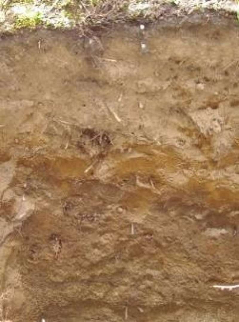
Figure 7. Profile of Vassar soil.
Table 5. Representative soil features
| Parent material |
(1)
Volcanic ash
(2) Alluvium (3) Colluvium – granite (4) Colluvium – metamorphic rock (5) Residuum – granite (6) Residuum – metamorphic rock |
|---|---|
| Surface texture |
(1) Ashy silt loam (2) Ashy loam (3) Medial silt loam |
| Family particle size |
(1) Ashy over loamy (2) Medial over loamy (3) Fine-silty |
| Drainage class | Well drained |
| Permeability class | Moderate |
| Depth to restrictive layer | 80 in |
| Surface fragment cover <=3" | 1 – 7% |
| Surface fragment cover >3" | Not specified |
| Available water capacity (0-40in) |
7.2 in |
| Calcium carbonate equivalent (0-60in) |
Not specified |
| Electrical conductivity (0-60in) |
Not specified |
| Soil reaction (1:1 water) (0-60in) |
5.2 – 5.8 |
| Subsurface fragment volume <=3" (10-60in) |
1 – 7% |
| Subsurface fragment volume >3" (10-60in) |
Not specified |
Table 6. Representative soil features (actual values)
| Drainage class | Moderately well drained to somewhat excessively drained |
|---|---|
| Permeability class | Very slow to moderate |
| Depth to restrictive layer | 40 – 80 in |
| Surface fragment cover <=3" | 7% |
| Surface fragment cover >3" | 5% |
| Available water capacity (0-40in) |
3.4 – 10.6 in |
| Calcium carbonate equivalent (0-60in) |
Not specified |
| Electrical conductivity (0-60in) |
Not specified |
| Soil reaction (1:1 water) (0-60in) |
4.6 – 6.2 |
| Subsurface fragment volume <=3" (10-60in) |
25% |
| Subsurface fragment volume >3" (10-60in) |
5% |
Ecological dynamics
The ecological dynamics of the Ashy Hills and Mountains 30-45” PZ Frigid Ecological Site are controlled by natural and human-caused disturbances which alter ecosystem structure and plant composition over time. The site is composed of diverse plant communities that vary depending on initial stand characteristics, such as differences in fire severity, management, and specific soil characteristics.
Stand-replacing events, such as severe fire or clearcutting, will shift the site into a shrub dominated phase composed of Ceanothus spp. on drier sites and oceanspray (Holodiscus discolor), Rocky Mountain maple (Acer glabrum), and common snowberry (Symphoricarpos albus) as the dominant shrubs on other sites. Further disturbances at this stage may prevent tree establishment for several decades and require intervention to restore the site to the reference state (Coop et al. 2020).
In the absence of further disturbances, early seral tree species will establish and become dominant, such as Rocky Mountain Douglas-fir (Pseudotsuga menziesii var. glauca), lodgepole pine (Pinus contorta), and western larch (Larix occidentalis) on drier sites. Grand fir (Abies grandis), western redcedar (Thuja plicata), and Englemann spruce (Picea engelmannii) establish as well but remain in the understory. As early seral trees establish and form a closed canopy, they shade the understory and prevent the establishment of new understory vegetation and tree regeneration (Oliver 1980).
Mixed severity fire and other disturbance mechanisms create canopy openings and allow for understory regeneration (Spies and Franklin 1989). Overtime, this results in a mosaic of mixed-age stands, with Douglas-fir being a dominant component of younger stands and western redcedar and grand fir dominating older stands. In mixed age stands, understory vegetation communities stabilize and include brides’ bonnet (Clintonia uniflora), starry false lily of the valley (Maianthemum stellatum), and Idaho goldthread (Coptic occidentalis).
With infrequent, low-severity fires or lack thereof for 150 year or more, western redcedar will persist to form even-aged stands (Daniels 2003). These stands have variable understory compositions and dynamics that are primarily controlled by individual tree mortality (Wells et al. 1998). Plants such as bride’s bonnet and twinflower (Linnaea borealis) often occur alongside grand fir and western redcedar regeneration.
State and transition model
More interactive model formats are also available.
View Interactive Models
Click on state and transition labels to scroll to the respective text
Ecosystem states
State 1 submodel, plant communities
| 1.1A | - | Stand replacing disturbance. |
|---|
State 2 submodel, plant communities
State 1
Reference
The Reference State (1) is highly variable and dynamic, with a large capacity to resist and respond to temporary changes in environmental conditions. The most common environmental changes occur as disturbances like fire, insects, fungal diseases, and human activities (Cahalan 1985). These disturbances alter not only the organic components of the state, such as plants and animals, but also alter inorganic components such as nutrient, sunlight, and water availability. As a result, community phases in this state are dictated by disturbance history, severity, and frequency. The community phases in the reference state represent unique and meaningful differences in ecological structure, function, and composition. The initiation phase (1.4) occurs immediately after a stand-replacing disturbance and has a high occurrence of deciduous shrubs and forbs. The stem exclusion phase (1.3) occurs following the rapid growth of early seral tree species after stand initiation. This even-aged stand crowds the overstory and limits the amount of sunlight reaching the understory, thus causing a lower abundance of shrubs and forbs. The understory reinitiation phase (1.2) follows after competition amongst and between species combined with low to mixed severity disturbances create a patchy overstory. This allows the regeneration of shrubs, forbs, and trees, resulting in a mixed age stand that is the most diverse and structurally complex within the reference state (Oliver 1980). Given adequate time since severe disturbance, the reference phase (1.1) will occur, consisting of large, old western redcedar individuals.
Dominant plant species
-
grand fir (Abies grandis), tree
-
western redcedar (Thuja plicata), tree
-
Rocky Mountain Douglas-fir (Pseudotsuga menziesii var. glauca), tree
-
western larch (Larix occidentalis), tree
-
western white pine (Pinus monticola), tree
-
Engelmann spruce (Picea engelmannii), tree
-
lodgepole pine (Pinus contorta), tree
-
Pacific yew (Taxus brevifolia), tree
-
ceanothus (Ceanothus), shrub
-
Rocky Mountain maple (Acer glabrum), shrub
-
common snowberry (Symphoricarpos albus), shrub
-
oceanspray (Holodiscus discolor), shrub
-
bride's bonnet (Clintonia uniflora), other herbaceous
-
starry false lily of the valley (Maianthemum stellatum), other herbaceous
-
Idaho goldthread (Coptis occidentalis), other herbaceous
-
American trailplant (Adenocaulon bicolor), other herbaceous
-
bunchberry dogwood (Cornus canadensis), other herbaceous
-
British Columbia wildginger (Asarum caudatum), other herbaceous
-
twinflower (Linnaea borealis), other herbaceous
Dominant resource concerns
-
Compaction
-
Wildfire hazard from biomass accumulation
Community 1.1
Reference

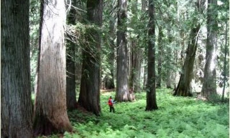
This phase is an old-growth stand, consisting mainly of large western redcedar trees exceeding 150 years of age. Dynamics are controlled by gap creation through individual tree death or windthrow. Tree regeneration that occurs following a canopy opening is typically advanced regeneration from western redcedar or grand fir saplings already present in the shaded understory (Franklin et al. 2002). Stands are structurally diverse with multiple snags, boles, and cavities. Old growth makes ideal habitat for many species of wildlife, provides aesthetic value, and helps sustain healthy watersheds (Cahalan, 1985).
Dominant plant species
-
western redcedar (Thuja plicata), tree
-
grand fir (Abies grandis), tree
-
Pacific yew (Taxus brevifolia), tree
-
Rocky Mountain Douglas-fir (Pseudotsuga menziesii var. glauca), tree
-
pipsissewa (Chimaphila umbellata), shrub
-
dwarf rose (Rosa gymnocarpa), shrub
-
longtube twinflower (Linnaea borealis ssp. longiflora), shrub
-
bride's bonnet (Clintonia uniflora), other herbaceous
-
starry false lily of the valley (Maianthemum stellatum), other herbaceous
-
western rattlesnake plantain (Goodyera oblongifolia), other herbaceous
-
Piper's anemone (Anemone piperi), other herbaceous
-
darkwoods violet (Viola orbiculata), other herbaceous
-
Pacific trillium (Trillium ovatum ssp. ovatum), other herbaceous
Community 1.2
Understory Reinitiation
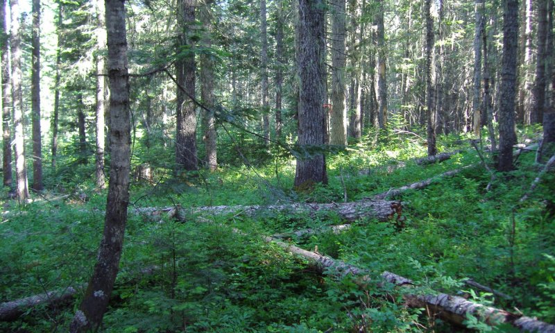
Mixed severity fires and tree mortality create a mosaic of mixed-age tree species. This phase is highly diverse and structurally complex. Vertical space from the ground to the overstory canopy is typically occupied by several species and plant functional groups, including forbs, shrubs, and different tree growth stages.
Dominant plant species
-
Rocky Mountain Douglas-fir (Pseudotsuga menziesii var. glauca), tree
-
grand fir (Abies grandis), tree
-
western redcedar (Thuja plicata), tree
-
western larch (Larix occidentalis), tree
-
Engelmann spruce (Picea engelmannii), tree
-
western white pine (Pinus monticola), tree
-
common snowberry (Symphoricarpos albus), shrub
-
bunchberry dogwood (Cornus canadensis), shrub
-
dwarf rose (Rosa gymnocarpa), shrub
-
thinleaf huckleberry (Vaccinium membranaceum), shrub
-
Rocky Mountain maple (Acer glabrum), shrub
-
Columbia brome (Bromus vulgaris), grass
-
bride's bonnet (Clintonia uniflora), other herbaceous
-
starry false lily of the valley (Maianthemum stellatum), other herbaceous
-
Idaho goldthread (Coptis occidentalis), other herbaceous
-
twinflower (Linnaea borealis), other herbaceous
-
British Columbia wildginger (Asarum caudatum), other herbaceous
-
American trailplant (Adenocaulon bicolor), other herbaceous
-
darkwoods violet (Viola orbiculata), other herbaceous
-
fragrant bedstraw (Galium triflorum), other herbaceous
-
western brackenfern (Pteridium aquilinum), other herbaceous
-
Pacific trillium (Trillium ovatum), other herbaceous
Community 1.3
Stem Exclusion
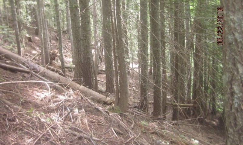
Once trees have established following a stand-replacing event, they grow rapidly to compete for sunlight and other resources. Canopy crowding leads to a sparsely vegetated understory and stands in this phase typically have low species diversity. The dense stands are comprised of young, small trees less than 60 years old and 16 inches in diameter.
Dominant plant species
-
Rocky Mountain Douglas-fir (Pseudotsuga menziesii var. glauca), tree
-
grand fir (Abies grandis), tree
-
western redcedar (Thuja plicata), tree
-
western larch (Larix occidentalis), tree
-
western white pine (Pinus monticola), tree
-
common snowberry (Symphoricarpos albus), shrub
-
pipsissewa (Chimaphila umbellata), shrub
-
bunchberry dogwood (Cornus canadensis), shrub
-
Rocky Mountain maple (Acer glabrum), shrub
-
thinleaf huckleberry (Vaccinium membranaceum), shrub
-
Columbia brome (Bromus vulgaris), grass
-
bride's bonnet (Clintonia uniflora), other herbaceous
-
starry false lily of the valley (Maianthemum stellatum), other herbaceous
-
Idaho goldthread (Coptis occidentalis), other herbaceous
-
American trailplant (Adenocaulon bicolor), other herbaceous
-
twinflower (Linnaea borealis), other herbaceous
Community 1.4
Stand Initiation
The initiation phase represents stands in the beginning stages of development post-disturbance. The phase ranges from sites that have bare mineral soil and no vertical structure, to sites that have standing dead wood and pockets of surviving vegetation. The commonality between communities in this phase is that the majority of large, mature trees have died due to disturbance. The result is an open canopy that favors the regeneration of deciduous shrubs, forbs, and early seral tree species. Species composition at a site post-disturbance depends on the seed bed present, and site distance from an existing seed source (Laughlin et al. 2023).
Dominant plant species
-
Rocky Mountain Douglas-fir (Pseudotsuga menziesii var. glauca), tree
-
western larch (Larix occidentalis), tree
-
western redcedar (Thuja plicata), tree
-
lodgepole pine (Pinus contorta), tree
-
ceanothus (Ceanothus), shrub
-
common snowberry (Symphoricarpos albus), shrub
-
dwarf rose (Rosa gymnocarpa), shrub
-
Rocky Mountain maple (Acer glabrum), shrub
-
Columbia brome (Bromus vulgaris), grass
-
bride's bonnet (Clintonia uniflora), other herbaceous
-
starry false lily of the valley (Maianthemum stellatum), other herbaceous
-
Idaho goldthread (Coptis occidentalis), other herbaceous
-
twinflower (Linnaea borealis), other herbaceous
-
Pacific trillium (Trillium ovatum), other herbaceous
Pathway 1.1A
Community 1.1 to 1.4
The pathway from the reference phase to the stand initiation phase is triggered by disturbances that kill the majority of trees. The dominant tree species found in the reference state are poorly adapted to fire (Daniels, 2003). Fire is the most common trigger, although other disturbances, such as logging, can cause a shift toward stand initiation.
Context dependence. The condition of the stand initiation phase will vary based on site characteristics pre-disturbance, as well as the type and severity of the disturbance (Franklin et al. 2002). Crown fires, burns that reach the upper canopy of trees, are rare in the reference phase due to the tall tree heights. Most fire occur along the ground, resulting in standing dead wood, or snags. Snags can persist for many years post-fire (Keeton and Franklin, 2004), and will alter the vertical structure and species composition of the stand initiation phase. The remaining cones on dead trees are a seed source that will aid in post-fire regeneration, while standing and downed wood may help maintain soil moisture (Greene et al., 2006). Post-fire salvage operations will reduce this cover and may reduce species diversity and productivity in the stand initiation phase (Morgan et al., 2015).
Pathway 1.2A
Community 1.2 to 1.1
The pathway from the understory reinitiation phase to the reference phase is maturation and structural diversification, and is only possible through time with infrequent disturbance (Franklin et al. 2002). Western redcedar is a slow growing tree capable of surviving for long periods of time in suboptimal conditions (Antos et al., 2016). Under a favorable disturbance regime, western redcedar will typically grow to become the dominant tree.
Context dependence. Every site has unique characteristics, such as soil properties, plant species and management history. Due to differences in initial conditions, sites do not converge at a single, distinct plant community. The trajectory of this pathway should be determined on a site-by-site basis and continually reevaluated with changing conditions and needs.
Pathway 1.2B
Community 1.2 to 1.4
Fire or logging operations that cause rapid mortality of most trees onsite will result in a change from the understory reinitiation phase to the stand initiation phase.
Context dependence. The effect of the disturbance and resulting stand initiation phase depend on initial site conditions and disturbance type and severity.
Pathway 1.3A
Community 1.3 to 1.2
The pathway from the stem exclusion phase to the understory reinitiation phase is disturbance and mortality through time. Mixed severity fires, silvicultural treatments, disease, or insects kill individual trees and create canopy gaps. Regeneration occurs as gaps allow sunlight to reach the understory, and tree mortality reduces resource competition.
Context dependence. Silvicultural treatments, such as thinning, can reduce the time a site spends in the stem exclusion phase (Case et al. 2023). Similarly, large disease outbreaks, such as root rot caused by the Armillaria fungus, can kill large patches of trees relatively quickly (Cahalan 1985).
Pathway 1.3B
Community 1.3 to 1.4
Fire or logging operations that cause rapid mortality of most trees onsite will result in a change from the stem exclusion phase to the stand initiation phase.
Context dependence. The effect of the disturbance and resulting stand initiation phase depend on initial site conditions and disturbance type and severity.
Pathway 1.4A
Community 1.4 to 1.3
This pathway occurs as several decades without disturbance to allow for the rapid regeneration of early seral trees. For stem exclusion to develop, trees must establish with a relatively high density, which requires a nearby, active seed source (Franklin et al. 2002). Dense tree establishment may also result from planting.
State 2
Shrub Fields
The Shrub Fields State (2) represents historically forested sites that have been converted to a persistent shrub state. Sites in this state develop due to severe disturbances which kill large areas of forested vegetation. A lack of seed source, environmental changes that are unfavorable for seedlings, or both, prevent a forested community from reestablishing (Coop et al., 2020). In the absence of trees, deciduous shrubs dominate the site. There is only one community phase defined for this site.
Dominant plant species
-
ceanothus (Ceanothus), shrub
-
Scouler's willow (Salix scouleriana), shrub
-
Saskatoon serviceberry (Amelanchier alnifolia), shrub
-
mallow ninebark (Physocarpus malvaceus), shrub
-
red elderberry (Sambucus racemosa), shrub
-
common snowberry (Symphoricarpos albus), shrub
-
white spirea (Spiraea betulifolia), shrub
-
Rocky Mountain maple (Acer glabrum), shrub
Community 2.1
Reference
Severe fires, an increase in disturbance frequency, and environmental changes favor the establishment of shrub cover. Tree regeneration is generally unsuccessful due to shrub competition and soil conditions. Shrubs that establish and dominate this phase depend on seed source and specific site conditions. Ceanothus (Ceanothus spp.), Sitka alder (Alnus sinuata), and Scouler’s willow (Salix scouleriana) tend to establish and dominate early stands post-fire. Several decades later, Ceanothus usually persists, and the more shade-tolerant Rocky Mountain maple (Acer glabrum) establishes (Mueggler, 1965).
Dominant plant species
-
ceanothus (Ceanothus), shrub
-
Sitka alder (Alnus viridis ssp. sinuata), shrub
-
Scouler's willow (Salix scouleriana), shrub
-
Rocky Mountain maple (Acer glabrum), shrub
-
red elderberry (Sambucus racemosa), shrub
-
Saskatoon serviceberry (Amelanchier alnifolia), shrub
-
white spirea (Spiraea betulifolia), shrub
Transition T1A
State 1 to 2
The transition from the Reference (1) to the Shrub Field (2) state is caused by significant changes in the fire regime and climate. Tree stress resulting from drought or warming temperature increases the likelihood of a severe fire burning a large area (Halofsky et al. 2020). Tree regeneration in large burn patches becomes difficult due to potentially long distances to a seed source (Laughlin et al. 2023). Seeds that do colonize the site often die due to continued drought conditions and are outcompeted by shrub species.
Restoration pathway R2A
State 2 to 1
It is unknown if the Reference State (1) is capable of recovering naturally due to a limited number of long-term observations and studies. The Shrub Field State (2) is predicted to persist for a long period of time (Johnstone et al. 2016, Coop et al. 2020). Therefore, the restoration pathway from the Shrub Field State (2) involves human intervention in the form of tree planting or other activities. Conditions should be reviewed on a site-by-site basis and the exact practices needed should be determined with local expertise.
Additional community tables
Table 7. Community 1.1 forest overstory composition
| Common name | Symbol | Scientific name | Nativity | Height (ft) | Canopy cover (%) | Diameter (in) | Basal area (square ft/acre) |
|---|---|---|---|---|---|---|---|
|
Tree
|
|||||||
| grand fir | ABGR | Abies grandis | Native | 120–130 | 25–75 | 18–21 | – |
| western redcedar | THPL | Thuja plicata | Native | – | 25–75 | – | – |
Table 8. Community 1.1 forest understory composition
| Common name | Symbol | Scientific name | Nativity | Height (ft) | Canopy cover (%) | |
|---|---|---|---|---|---|---|
|
Forb/Herb
|
||||||
| Idaho goldthread | COOC | Coptis occidentalis | Native | – | 25–50 | |
| bride's bonnet | CLUN2 | Clintonia uniflora | Native | – | 5–25 | |
| twinflower | LIBO3 | Linnaea borealis | Native | – | 5–25 | |
| British Columbia wildginger | ASCA2 | Asarum caudatum | Native | – | 5–25 | |
|
Shrub/Subshrub
|
||||||
| bunchberry dogwood | COCA13 | Cornus canadensis | Native | – | 1–5 | |
Table 9. Community 1.2 forest overstory composition
| Common name | Symbol | Scientific name | Nativity | Height (ft) | Canopy cover (%) | Diameter (in) | Basal area (square ft/acre) |
|---|---|---|---|---|---|---|---|
|
Tree
|
|||||||
| grand fir | ABGR | Abies grandis | Native | 80–135 | 20–90 | 12–22 | – |
| Rocky Mountain Douglas-fir | PSMEG | Pseudotsuga menziesii var. glauca | Native | 75–125 | 5–65 | 13–22 | – |
| western redcedar | THPL | Thuja plicata | Native | – | 2–30 | – | – |
| Engelmann spruce | PIEN | Picea engelmannii | Native | 90–110 | 1–23 | 12–16 | – |
| western larch | LAOC | Larix occidentalis | Native | 90–125 | 1–20 | 12–18 | – |
| western white pine | PIMO3 | Pinus monticola | Native | 100–125 | 1–5 | 14–17 | – |
Table 10. Community 1.2 forest understory composition
| Common name | Symbol | Scientific name | Nativity | Height (ft) | Canopy cover (%) | |
|---|---|---|---|---|---|---|
|
Grass/grass-like (Graminoids)
|
||||||
| Columbia brome | BRVU | Bromus vulgaris | Native | – | 0–1 | |
|
Forb/Herb
|
||||||
| bride's bonnet | CLUN2 | Clintonia uniflora | Native | – | 5–25 | |
| starry false lily of the valley | MAST4 | Maianthemum stellatum | Native | – | 5–25 | |
| Idaho goldthread | COOC | Coptis occidentalis | Native | – | 5–25 | |
| twinflower | LIBO3 | Linnaea borealis | Native | – | 1–5 | |
| British Columbia wildginger | ASCA2 | Asarum caudatum | Native | – | 1–5 | |
| American trailplant | ADBI | Adenocaulon bicolor | Native | – | 1–5 | |
| darkwoods violet | VIOR | Viola orbiculata | Native | – | 1–5 | |
| fragrant bedstraw | GATR3 | Galium triflorum | Native | – | 1–5 | |
| Pacific trillium | TROV2 | Trillium ovatum | Native | – | 0–1 | |
|
Fern/fern ally
|
||||||
| western brackenfern | PTAQ | Pteridium aquilinum | Native | – | 0–1 | |
|
Shrub/Subshrub
|
||||||
| common snowberry | SYAL | Symphoricarpos albus | Native | – | 1–5 | |
| bunchberry dogwood | COCA13 | Cornus canadensis | Native | – | 1–5 | |
| dwarf rose | ROGY | Rosa gymnocarpa | Native | – | 1–5 | |
| thinleaf huckleberry | VAME | Vaccinium membranaceum | Native | – | 1–5 | |
| Rocky Mountain maple | ACGL | Acer glabrum | Native | – | 1–5 | |
Table 11. Community 1.3 forest overstory composition
| Common name | Symbol | Scientific name | Nativity | Height (ft) | Canopy cover (%) | Diameter (in) | Basal area (square ft/acre) |
|---|---|---|---|---|---|---|---|
|
Tree
|
|||||||
| grand fir | ABGR | Abies grandis | Native | 80–135 | 35–95 | 13–23 | – |
| western redcedar | THPL | Thuja plicata | Native | – | 1–40 | – | – |
| Rocky Mountain Douglas-fir | PSMEG | Pseudotsuga menziesii var. glauca | Native | 70–110 | 5–40 | 11–19 | – |
| western larch | LAOC | Larix occidentalis | Native | 70–130 | 1–25 | 9–15 | – |
Table 12. Community 1.3 forest understory composition
| Common name | Symbol | Scientific name | Nativity | Height (ft) | Canopy cover (%) | |
|---|---|---|---|---|---|---|
|
Grass/grass-like (Graminoids)
|
||||||
| Columbia brome | BRVU | Bromus vulgaris | Native | – | 0–1 | |
|
Forb/Herb
|
||||||
| bride's bonnet | CLUN2 | Clintonia uniflora | Native | – | 1–5 | |
| starry false lily of the valley | MAST4 | Maianthemum stellatum | Native | – | 1–5 | |
| Idaho goldthread | COOC | Coptis occidentalis | Native | – | 1–5 | |
| American trailplant | ADBI | Adenocaulon bicolor | Native | – | 1–5 | |
| twinflower | LIBO3 | Linnaea borealis | Native | – | 0–1 | |
|
Shrub/Subshrub
|
||||||
| common snowberry | SYAL | Symphoricarpos albus | Native | – | 1–5 | |
| thinleaf huckleberry | VAME | Vaccinium membranaceum | Native | – | 1–5 | |
| bunchberry dogwood | COCA13 | Cornus canadensis | Native | – | 1–5 | |
| Rocky Mountain maple | ACGL | Acer glabrum | Native | – | 0–1 | |
| pipsissewa | CHUM | Chimaphila umbellata | Native | – | 0–1 | |
Table 13. Community 1.4 forest overstory composition
| Common name | Symbol | Scientific name | Nativity | Height (ft) | Canopy cover (%) | Diameter (in) | Basal area (square ft/acre) |
|---|---|---|---|---|---|---|---|
|
Tree
|
|||||||
| grand fir | ABGR | Abies grandis | Native | 65–115 | 48–90 | 9–19 | – |
| Rocky Mountain Douglas-fir | PSMEG | Pseudotsuga menziesii var. glauca | Native | 60–70 | 4–50 | 9–14 | – |
Interpretations
Table 14. Representative site productivity
| Common name | Symbol | Site index low | Site index high | CMAI low | CMAI high | Age of CMAI | Site index curve code | Site index curve basis | Citation |
|---|---|---|---|---|---|---|---|---|---|
| western white pine | PIMO3 | 75 | 110 | 144 | 201 | 100 | – | – | |
| grand fir | ABGR | 87 | 106 | 106 | 201 | 95 | – | – | |
| Rocky Mountain Douglas-fir | PSMEG | 81 | 97 | 65 | 152 | 104 | – | – | |
| western larch | LAOC | 84 | 98 | 74 | 146 | 70 | – | – | |
| Engelmann spruce | PIEN | 110 | 112 | – | – | – | – | – |
Supporting information
References
-
Cooper, S.V., K.E. Neiman, R. Steele, and D.W. Roberts. 1991. Forest Habitat types of Northern Idaho, A Second Approximation.
Other references
Cahalan, C. 1985. Silvicultural systems for the major forest types of the United States. Forest Ecology and Management 11:297.
Case, M. J., A. K. Ettinger, and K. Pradhan. 2023. Forest restoration thinning accelerates development of old-growth characteristics in the coastal Pacific Northwest, USA. Conservation Science and Practice 5:e13004.
Coop, J. D., S. A. Parks, C. S. Stevens-Rumann, S. D. Crausbay, P. E. Higuera, M. D. Hurteau, A. Tepley, E. Whitman, T. Assal, B. M. Collins, K. T. Davis, S. Dobrowski, D. A. Falk, P. J. Fornwalt, P. Z. Fulé, B. J. Harvey, V. R. Kane, C. E. Littlefield, E. Q. Margolis, M. North, M.-A. Parisien, S. Prichard, and K. C. Rodman. 2020. Wildfire-Driven Forest Conversion in Western North American Landscapes. BioScience 70:659–673.
Daniels, L. D. 2003. Western redcedar population dynamics in old-growth forests: Contrasting ecological paradigms using tree rings. The Forestry Chronicle 79:517–530.
Franklin, J. F., T. A. Spies, R. V. Pelt, A. B. Carey, D. A. Thornburgh, D. R. Berg, D. B. Lindenmayer, M. E. Harmon, W. S. Keeton, D. C. Shaw, K. Bible, and J. Chen. 2002. Disturbances and structural development of natural forest ecosystems with silvicultural implications, using Douglas-fir forests as an example. Forest Ecology and Management 155:399–423.
Halofsky, J. E., D. L. Peterson, and B. J. Harvey. 2020. Changing wildfire, changing forests: the effects of climate change on fire regimes and vegetation in the Pacific Northwest, USA. Fire Ecology 16:4.
Johnstone, J. F., C. D. Allen, J. F. Franklin, L. E. Frelich, B. J. Harvey, P. E. Higuera, M. C. Mack, R. K. Meentemeyer, M. R. Metz, G. L. Perry, T. Schoennagel, and M. G. Turner. 2016. Changing disturbance regimes, ecological memory, and forest resilience. Frontiers in Ecology and the Environment 14:369–378.
Laughlin, M. M., L. K. Rangel-Parra, J. E. Morris, D. C. Donato, J. S. Halofsky, and B. J. Harvey. 2023. Patterns and drivers of early conifer regeneration following stand-replacing wildfire in Pacific Northwest (USA) temperate maritime forests. Forest Ecology and Management 549:121491.
McCabe, G. J., M. P. Clark, and L. E. Hay. 2007. Rain-on-Snow Events in the Western United States. Bulletin of the American Meteorological Society 88:319–328.
McDaniel, P. A., and K. W. Hipple. 2010. Mineralogy of loess and volcanic ash eolian mantles in Pacific Northwest (USA) landscapes. Geoderma 154:438–446.
Oliver, C. D. 1980. Forest development in North America following major disturbances. Forest Ecology and Management 3:153–168.
Spies, T. A., and J. F. Franklin. 1989. Gap Characteristics and Vegetation Response in Coniferous Forests of the Pacific Northwest. Ecology 70:543–545.
Wells, Ralph W.; Lertzman, Kenneth P.; Saunders, Sari C. 1998. Old-growth definitions for the forests of British Columbia, Canada. Natural Areas Journal 18(4): 279-292.
Approval
Kirt Walstad, 5/05/2025
Rangeland health reference sheet
Interpreting Indicators of Rangeland Health is a qualitative assessment protocol used to determine ecosystem condition based on benchmark characteristics described in the Reference Sheet. A suite of 17 (or more) indicators are typically considered in an assessment. The ecological site(s) representative of an assessment location must be known prior to applying the protocol and must be verified based on soils and climate. Current plant community cannot be used to identify the ecological site.
| Author(s)/participant(s) | |
|---|---|
| Contact for lead author | |
| Date | 12/18/2020 |
| Approved by | Kirt Walstad |
| Approval date | |
| Composition (Indicators 10 and 12) based on | Annual Production |
Indicators
-
Number and extent of rills:
-
Presence of water flow patterns:
-
Number and height of erosional pedestals or terracettes:
-
Bare ground from Ecological Site Description or other studies (rock, litter, lichen, moss, plant canopy are not bare ground):
-
Number of gullies and erosion associated with gullies:
-
Extent of wind scoured, blowouts and/or depositional areas:
-
Amount of litter movement (describe size and distance expected to travel):
-
Soil surface (top few mm) resistance to erosion (stability values are averages - most sites will show a range of values):
-
Soil surface structure and SOM content (include type of structure and A-horizon color and thickness):
-
Effect of community phase composition (relative proportion of different functional groups) and spatial distribution on infiltration and runoff:
-
Presence and thickness of compaction layer (usually none; describe soil profile features which may be mistaken for compaction on this site):
-
Functional/Structural Groups (list in order of descending dominance by above-ground annual-production or live foliar cover using symbols: >>, >, = to indicate much greater than, greater than, and equal to):
Dominant:
Sub-dominant:
Other:
Additional:
-
Amount of plant mortality and decadence (include which functional groups are expected to show mortality or decadence):
-
Average percent litter cover (%) and depth ( in):
-
Expected annual annual-production (this is TOTAL above-ground annual-production, not just forage annual-production):
-
Potential invasive (including noxious) species (native and non-native). List species which BOTH characterize degraded states and have the potential to become a dominant or co-dominant species on the ecological site if their future establishment and growth is not actively controlled by management interventions. Species that become dominant for only one to several years (e.g., short-term response to drought or wildfire) are not invasive plants. Note that unlike other indicators, we are describing what is NOT expected in the reference state for the ecological site:
-
Perennial plant reproductive capability:
Print Options
Sections
Font
Other
The Ecosystem Dynamics Interpretive Tool is an information system framework developed by the USDA-ARS Jornada Experimental Range, USDA Natural Resources Conservation Service, and New Mexico State University.
Click on box and path labels to scroll to the respective text.
Ecosystem states
State 1 submodel, plant communities
| 1.1A | - | Stand replacing disturbance. |
|---|