Natural Resources
Conservation Service
Ecological site R025XY061OR
SHALLOW CLAYPAN 8-11 PZ
Last updated: 4/25/2024
Accessed: 05/20/2025
General information
Provisional. A provisional ecological site description has undergone quality control and quality assurance review. It contains a working state and transition model and enough information to identify the ecological site.
MLRA notes
Major Land Resource Area (MLRA): 025X–Owyhee High Plateau
The Owyhee High Plateau, MLRA 25, lies within the Intermontane Plateaus physiographic province. The southern half is found in the Great Basin while the northern half is located in the Columbia Plateaus. The southern section of the Owyhee High Plateau is characterized by isolated, uplifted fault-block mountain ranges separated by narrow, aggraded desert plains. This geologically older terrain has been dissected by numerous streams draining to the Humboldt River. The northern section forms the southern boundary of the extensive Columbia Plateau basalt flows. Deep, narrow canyons drain to the Snake River across the broad volcanic plain.
This MLRA is characteristically cooler and wetter than the neighboring MLRAs of the Great Basin. Elevation ranges from 3,000 to 7,550 feet on rolling plateaus and in gently sloping basins. It is more than 9,840 feet on some steep mountains. The average annual precipitation in most of this area is typically 11 to 22 inches. It increases to as much as 49 inches at the higher elevations. Precipitation occurs mainly as snow in winter. The supply of water from precipitation and streamflow is small and unreliable, except along major rivers. Streamflow depends largely on accumulated snow in the mountains.
The dominant soil orders in this MLRA are Aridisols and Mollisols. The soils in the area dominantly have a mesic or frigid temperature regime and an aridic, arid bordering on xeric, or xeric moisture regime. Most of the soils formed in mixed parent material. Volcanic ash and loess mantle the landscape. Surface soil textures are loam and silt loam, and have ashy texture modifiers in some cases. Argillic horizons occur on the more stable landforms.
Ecological site concept
This ecological site is on gently sloping foothills and broad tablelands associated with volcanic plateau landscapes. Elevations range from 3,500 to 4,500 feet. The soils associated with this site are moderately deep to a duripan or lithic contact and have an abrupt boundary in the top 10 inches resulting in wet non-satiated conditions. The soil climate is mesic-aridic. The reference plant community is characterized by low sagebrush and a mix of bluebunch wheatgrass and Sandberg bluegrass in the understory.
(wet non-saturated conditions - Schoeneberger, P.J., 2012, pg 1-15)
Associated sites
| R025XY010OR |
LOAMY 8-11 PZ |
|---|---|
| R025XY011OR |
VERY SHALLOW 8-13 PZ |
Similar sites
| R025XY016OR |
SHALLOW CLAYPAN 11-13 PZ This site has higher precipitation and production, is frigid, and the perennial deep rooted grass layer is dominated by Idaho fescue. |
|---|---|
| R025XY011OR |
VERY SHALLOW 8-13 PZ This site is on very shallow and shallow soils with high rock fragment content. Production is much lower and vegetation is dominated by stiff sage (Artemesia rigida) and Sandberg bluegrass. |
Table 1. Dominant plant species
| Tree |
Not specified |
|---|---|
| Shrub |
(1) Artemisia arbuscula |
| Herbaceous |
(1) Pseudoroegneria spicata subsp. spicata |
Physiographic features
This site is on plateaus and tablelands. Slopes range from 2 to 15 percent. Elevations range from 3,500 to 4,500 feet.
Table 2. Representative physiographic features
| Landforms |
(1)
Plateau
(2) Tableland |
|---|---|
| Runoff class | Medium to high |
| Elevation | 1,067 – 1,372 m |
| Slope | 2 – 15% |
| Water table depth | 254 cm |
| Aspect | Aspect is not a significant factor |
Climatic features
The annual precipitation ranges from 8 to 11 inches, most of which occurs in the form of snow during the months of December through March. Localized convection storms occasionlly occur during the summer. The soil temperature regime is mesic to near frigid with a mean air temperture of 46.5 degrees F. Temperature extremes range from 10 to 90 degrees F. The frost free period ranges from less than 90 to 120 days. The optimum growth period for native plants is from April through June.
Table 3. Representative climatic features
| Frost-free period (characteristic range) | 90-120 days |
|---|---|
| Freeze-free period (characteristic range) | 100-130 days |
| Precipitation total (characteristic range) | 203-279 mm |
| Frost-free period (average) | 105 days |
| Freeze-free period (average) | 120 days |
| Precipitation total (average) | 254 mm |
Figure 1. Monthly precipitation range
Figure 2. Monthly minimum temperature range
Figure 3. Monthly maximum temperature range
Figure 4. Monthly average minimum and maximum temperature
Figure 5. Annual precipitation pattern
Figure 6. Annual average temperature pattern
Climate stations used
-
(1) ROME 2 NW [USC00357310], Jordan Valley, OR
Influencing water features
Site is not influenced by water features.
This site is not connected to a water table.
Soil features
The soils associated with this site are moderately deep over bedrock or an indurated pan. The surface layer is an ashy silt loam to a silty clay loam less than 10 inches thick. The subsoil is clay to clay loam. An abrupt boundary occurs at the interface of the surface and subsoil. Depth to bedrock or an indurated pan is 20 to 40 inches. Permeability is moderate to moderately slow in the surface layer and slow in the subsoil. The available water holding capacity is about 2 to 3 inches for the profile.
The soil series correlated with this site are Carryback and Suncold.
(wet non-saturated conditions - Schoeneberger, P.J., 2012, pg 1-15)
Table 4. Representative soil features
| Parent material |
(1)
Volcanic ash
(2) Residuum – volcanic rock (3) Loess – volcanic rock |
|---|---|
| Surface texture |
(1) Ashy silt loam (2) Silty clay loam |
| Family particle size |
(1) Fine |
| Drainage class | Moderately well drained to well drained |
| Permeability class | Moderate to very slow |
| Depth to restrictive layer | 51 – 102 cm |
| Soil depth | 51 – 102 cm |
| Surface fragment cover <=3" | 0 – 15% |
| Surface fragment cover >3" | 0 – 15% |
| Available water capacity (0-101.6cm) |
5.08 – 10.16 cm |
| Soil reaction (1:1 water) (0-101.6cm) |
7 – 8 |
| Subsurface fragment volume <=3" (0-101.6cm) |
0 – 15% |
| Subsurface fragment volume >3" (0-101.6cm) |
0 – 15% |
Ecological dynamics
The reference plant community is dominated by low sagebrush (little sagebrush) with an understory of bluebunch wheatagrass. Sandberg bluegrass and Cusick bluegrass are prominent in the stand. The site has low resilience to disturbance and resistance to invasion. Resilience is a system’s capacity to regain its structure, processes, and function following stressors or disturbance (e.g. drought or fire). Resistance is the capacity of the system to retain its structure, processes, and function despite stressors or disturbances (including pressure from invasive species) (Chambers 2014a). Increased resilience increases with elevation, aspect, increased precipitation and increased nutrient availability (Stringham et al. 2015); where greater resource availability and more favorable environmental conditions exist for plant growth and reproduction (Chambers 2014a).
This ecological site’s lower effective precipitation (aridic soil moisture regime) and restrictive soil features limit site productivity resulting in more open space for establishment of invasive annual grasses. Timing of precipitation also favors invasive annual grasses that are particularly well adapted to cool wet winters and warm dry summers; beginning growth and utilizing resources prior to native species breaking dormancy. The site’s warmer soil temperature regime (mesic) is also optimal for annual grass establishment and growth. Once annuals are on the site, they are very effective at outcompeting native seedlings, allowing for continued expansion (Chambers 2014b).
This site shows little variation in composition and production. Bluebunch wheatgrass production will increase as the soils become deeper. Sandberg bluegrass will increase as the soils become shallower. Idaho fescue will increase at the upper end of the precipitation zone.
If the condition of the site deteriorates due to extended disturbance, bluebunch wheatgrasss and Cusick bluegrass will decrease while low sagebrush and Sandberg bluegrass will increase. With further deterioration, annuals will invade and bare ground will markedly increase. Excessive erosion in the bare soil interspaces reduces the site productivity.
This ecological site is dominated by deep-rooted cool season, perennial bunchgrasses and long-lived shrubs (50+ years) with high root to shoot ratios. Community types with low sagebrush as the dominant shrub were found to have soil depths and thus available rooting depths of 71 to 81 centimeters in a study in northeast Nevada (Jensen 1990). These shrubs have a flexible generalized root system with development of both deep taproots and laterals near the surface (Comstock and Ehleringer 1992).
Periodic drought regularly influences sagebrush ecosystems and drought duration and severity has increased throughout the 20th century in much of the Intermountain West. Major shifts away from historical precipitation patterns have the greatest potential to alter ecosystem function and productivity. Species composition and productivity can be altered by the timing of precipitation and water availability with the soil profile (Bates et al. 2006).
Low sagebrush is fairly drought tolerant but also tolerates periodic wetness during some portion of the growing season. Low sagebrush is also susceptible to the sagebrush defoliator Aroga moth. Aroga moth can partially or entirely kill individual plants or entire stands of big sagebrush (Furniss and Barr 1975), but the research is inconclusive of the damage sustained by low sagebrush populations.
The low sagebrush communities have high spatial and temporal variability in precipitation both among years and within growing seasons. Nutrient availability is typically low but increases with elevation and closely follows moisture availability. The invasibility of plant communities is often linked to resource availability. Disturbance can decrease resource uptake due to damage or mortality of the native species and depressed competition. It can also increase resource pools by the decomposition of dead plant material following disturbance. The invasion of sagebrush communities by cheatgrass (Bromus tectorum) has been linked to disturbances (fire, abusive grazing) that have resulted in fluctuations in resources (Chambers et al. 2007).
The dominant perennial bunchgrass on this site is bluebunch wheatgrass. Perennial bunchgrasses generally have shallower root systems than the shrubs, but root densities are often as high as or higher than those of shrubs in the upper 0.5 m of the soil profile. General differences in root depth distributions between grasses and shrubs results in resource partitioning in these shrub/grass systems.
As ecological condition declines, the sagebrush and rabbitbrush become dominant with increases of Sandberg’s bluegrass, bottlebrush squirreltail and mat forming forbs in the understory. The potential invasive/noxious weeds are cheatgrass, rabbitbrush, and annual mustards.
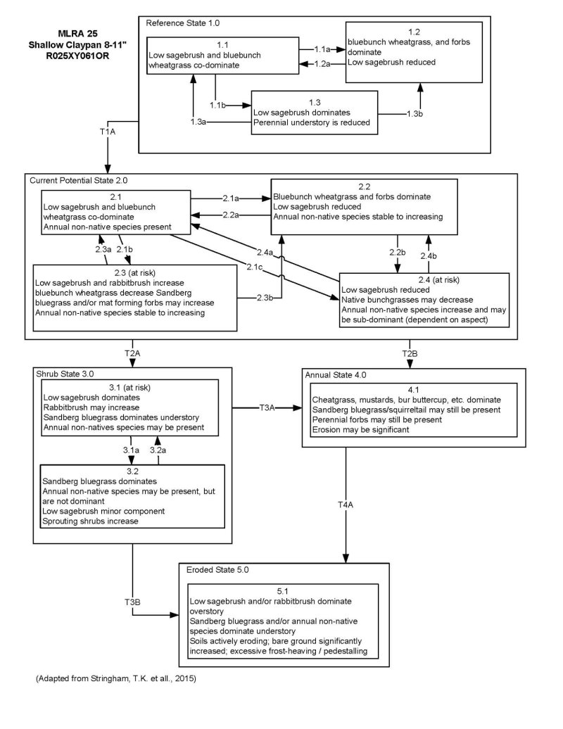
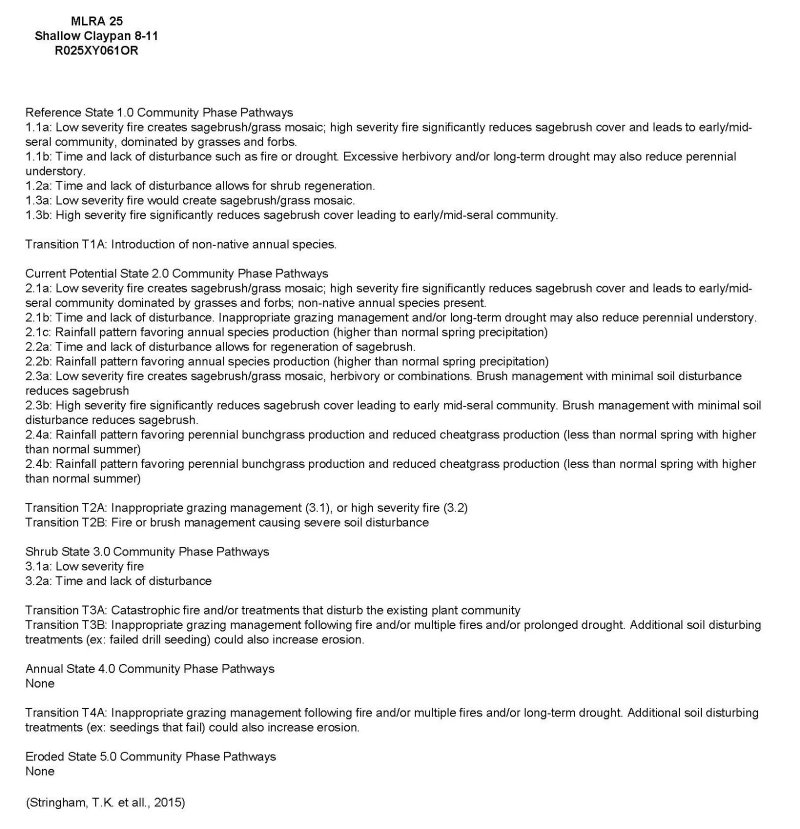
Four possible alternative stable states have been identified for this ecological site.
Fire Ecology:
Prior to 1897, mean fire return intervals for low sagebrush communities have been estimated to be from 35 to over 100 years. Fire most often occurs during wet years with high forage production.
Low sagebrush is killed by fire and does not sprout (Tisdale and Hironaka 1984). Establishment after fire is from seed, generally blown in and not from the seed bank (Bradley et al. 1992). Fire risk is greatest following a wet, productive year when there is greater production of fine fuels (Beardall and Sylvester 1976). Fire return intervals have been estimated at 100-200 years in black sagebrush-dominated sites (Kitchen and McArthur 2007) and likely is similar in the low sagebrush ecosystem. Historically, however, fires were probably patchy due to the low productivity of these sites. Recovery time of little sagebrush following fire is variable (Young 1983). After fire, if regeneration conditions are favorable, low sagebrush recovers in 2 to 5 years; on harsh sites where cover is low to begin with and/or erosion occurs after fire, recovery may require more than 10 years (Young 1983). Slow regeneration may subsequently worsen erosion (Blaisdell et al. 1982).
The effect of fire on bunchgrasses relates to culm density, culm-leaf morphology, and the size of the plant. The initial condition of bunchgrasses within the site along with seasonality and intensity of the fire all factor into the individual species response. The growing points for most forbs and grasses are located at or below the soil surface, providing relative protection from disturbances which decrease above ground biomass, such as grazing or fire. Thus, fire mortality is more correlated to duration and intensity of heat which is related to culm density, culm-leaf morphology, size of plant and abundance of old growth (Wright 1971, Young 1983). However, season and severity of the fire and post-fire soil moisture availability will influence plant response.
Bluebunch wheatgrass has coarse stems with little leafy material, therefore the tops aboveground biomass burns rapidly and little heat is transferred downward into the crowns (Young 1983). Bluebunch wheatgrass was described as fairly tolerant of burning, other than in May in eastern Oregon (Britton et al. 1990). Uresk et al. (1976) reported burning increased vegetative and reproductive vigor of bluebunch wheatgrass. Thus, bluebunch wheatgrass is considered to experience slight damage to fire but is more susceptible in drought years (Young 1983). Most authors classify the plant as undamaged by fire (Kuntz 1982).
Adapted from: Stringham, T.K., P. Novak-Echenique, P. Blackburn, D. Snyder, and A. Wartgow. 2015. Final Report for USDA Ecological Site Description State-and-Transition Models by Disturbance Response Groups, Major Land Resource Area 25 Nevada. University of Nevada Reno, Nevada Agricultural Experiment Station Research Report 2015-02. p. 569
State and transition model
More interactive model formats are also available.
View Interactive Models
Click on state and transition labels to scroll to the respective text
State 1 submodel, plant communities
State 2 submodel, plant communities
State 3 submodel, plant communities
State 4 submodel, plant communities
State 5 submodel, plant communities
State 1
Reference State 1.0
The Reference State 1.0 is representative of the natural range of variability under pristine conditions. The reference state has three general community phases: a shrub-grass dominant phase, a perennial grass dominant phase and a shrub dominant phase. State dynamics are maintained by interactions between climatic patterns and disturbance regimes. Negative feedbacks enhance ecosystem resilience and contribute to the stability of the state. These include the presence of all structural and functional groups, low fine fuel loads, and retention of organic matter and nutrients. Plant community phase changes are primarily driven by fire, periodic drought and/or insect or disease attack.
Community 1.1
Reference Plant Community
This community is dominated by low sagebrush and bluebunch wheatgrass. Cusick bluegrass and Sandberg bluegrass are prominent in the stand. Idaho fescue is present. Forbs and other grasses make up smaller components.
Figure 7. Annual production by plant type (representative values) or group (midpoint values)
Table 5. Annual production by plant type
| Plant type | Low (kg/hectare) |
Representative value (kg/hectare) |
High (kg/hectare) |
|---|---|---|---|
| Grass/Grasslike | 448 | 538 | 628 |
| Shrub/Vine | 84 | 101 | 118 |
| Forb | 28 | 34 | 39 |
| Total | 560 | 673 | 785 |
Community 1.2
This community phase is characteristic of a post-disturbance, early/mid-seral community. Bluebunch wheatgrass and other perennial bunchgrasses dominate. Depending on fire severity patches of intact sagebrush may remain. Rabbitbrush and other sprouting shrubs may be sprouting. Perennial forbs may be a significant component for a number of years following fire.
Community 1.3
Sagebrush increases in the absence of disturbance. Decadent sagebrush dominates the overstory and the deep-rooted perennial bunchgrasses in the understory are reduced either from competition with shrubs and/or from herbivory.
Pathway P1.1a
Community 1.1 to 1.2
Fire will decrease or eliminate the overstory of sagebrush and allow for the perennial bunchgrasses to dominate the site. Fires will typically be low severity resulting in a mosaic pattern due to low fuel loads. A fire following an unusually wet spring may be more severe and reduce sagebrush cover to trace amounts.
Pathway P1.1b
Community 1.1 to 1.3
Time and lack of disturbance such as fire allows for sagebrush to increase and become decadent. Long-term drought, herbivory, or combinations of these will cause a decline in perennial bunchgrasses and fine fuels leading to a reduced fire frequency and allowing sagebrush to dominate the site.
Pathway P1.2a
Community 1.2 to 1.3
Time and lack of disturbance will allow sagebrush to increase.
Pathway P1.3a
Community 1.3 to 1.1
A low severity fire, herbivory or combinations will reduce the sagebrush overstory and create a sagebrush/grass mosaic.
Pathway P1.3b
Community 1.3 to 1.2
Fire will decrease or eliminate the overstory of sagebrush and allow for the perennial bunchgrasses to dominate the site. Fires may be high severity in this community phase due to the dominance of sagebrush resulting in removal of overstory shrub community.
State 2
Current Potential State 2.0
This state is similar to the Reference State 1.0. Ecological function has not changed, however the resiliency of the state has been reduced by the presence of invasive weeds. This state has the same three general community phases. These non-native species can be highly flammable, and promote fire where historically fire had been infrequent. Negative feedbacks enhance ecosystem resilience and contribute to the stability of the state. These feedbacks include the presence of all structural and functional groups, low fine fuel loads, and retention of organic matter and nutrients. Positive feedbacks decrease ecosystem resilience and stability of the state. These include the nonnatives’ high seed output, persistent seed bank, rapid growth rate, ability to cross pollinate, and adaptations for seed dispersal.
Community 2.1
This community phase is similar to the Reference State Community Phase 1.1, with the presence of non-native species in trace amounts. Sagebrush and bluebunch wheatgrass dominate the site. Forbs and other shrubs and grasses make up smaller components of this site.
Community 2.2
This community phase is characteristic of a post-disturbance, early to mid-seral community where annual non-native species are present. Sagebrush is present in trace amounts; perennial bunchgrasses dominate the site. Depending on fire severity patches of intact sagebrush may remain. Rabbitbrush may be sprouting or dominant in the community. Perennial forbs may be a significant component for a number of years following fire. Annual non-native species are stable or increasing within the community.
Community 2.3
(At Risk)
This community is at risk of crossing a threshold to another state. Sagebrush dominates the overstory and perennial bunchgrasses in the understory are reduced, either from competition with shrubs or from inappropriate grazing, or from both. Rabbitbrush may be a significant component. Sandberg bluegrass may increase and become co-dominate with deep rooted bunchgrasses. Annual non-natives species may be stable or increasing due to lack of competition with perennial bunchgrasses. This site is susceptible to further degradation from grazing, drought, and fire.
Community 2.4
(At Risk)
This community is at risk of crossing into an annual state. Native bunchgrasses dominate; however, annual non-native species such as cheatgrass may be sub-dominant in the understory. Annual production and abundance of these annuals may increase drastically in years with heavy spring precipitation. Sagebrush is a minor component. This site is susceptible to further degradation from grazing, drought, and fire.
Pathway P2.1a
Community 2.1 to 2.2
Fire reduces the shrub overstory and allows for perennial bunchgrasses to dominate the site. Fires are typically low severity resulting in a mosaic pattern due to low fuel loads. A fire following an unusually wet spring or a change in management favoring an increase in fine fuels may be more severe and reduce sagebrush cover to trace amounts. Annual non-native species are likely to increase after fire.
Pathway P2.1b
Community 2.1 to 2.3
Time and lack of disturbance allows for sagebrush to increase and become decadent. Long-term drought reduces fine fuels and leads to a reduced fire frequency, allowing sagebrush to dominate the site. Inappropriate grazing management reduces the perennial bunchgrass understory; conversely Sandberg bluegrass may increase in the understory depending on grazing management.
Pathway P2.1c
Community 2.1 to 2.4
Higher than normal spring precipitation favors annual nonnative species such as cheatgrass. Non-native annual species will increase in production and density throughout the site. Perennial bunchgrasses may also increase in production.
Pathway P2.2a
Community 2.2 to 2.1
Time and lack of disturbance and/or grazing management that favors the establishment and growth of sagebrush allows the shrub component to recover. The establishment of low sagebrush can take many years.
Pathway P2.2b
Community 2.2 to 2.4
Higher than normal spring precipitation favors annual nonnative species such as cheatgrass. Non-native annual species will increase in production and density throughout the site. Perennial bunchgrasses may also increase in production.
Pathway P2.3a
Community 2.3 to 2.1
A change in grazing management that reduces shrubs will allow for the perennial bunchgrasses in the understory to increase. Heavy late-fall or winter grazing may cause mechanical damage and subsequent death to sagebrush, facilitating an increase in the herbaceous understory. Brush treatments with minimal soil disturbance will also decrease sagebrush and release the perennial understory. A low severity fire would decrease the overstory of sagebrush and low for the understory perennial grasses to increase. Due to low fuel loads in this State, fires will likely be small creating a mosaic pattern. Annual non-native species are present and may increase in the community.
Pathway P2.3b
Community 2.3 to 2.2
Fire eliminates/reduces the overstory of sagebrush and allows for the understory perennial grasses to increase. Fires may be high severity in this community phase due to the dominance of sagebrush resulting in removal of overstory shrub community. Annual non-native species respond well to fire and may increase post burn.
Pathway P2.4a
Community 2.4 to 2.1
Rainfall patterns favoring perennial bunchgrasses. Less than normal spring precipitation followed by higher than normal summer precipitation will increase perennial bunchgrass production.
Pathway P2.4b
Community 2.4 to 2.2
Rainfall patterns favoring perennial bunchgrasses. Less than normal spring precipitation followed by higher than normal summer precipitation will increase perennial bunchgrass production.
State 3
Shrub State 3.0
This state is a product of many years of heavy grazing during time periods harmful to perennial bunchgrasses. Sandberg bluegrass will increase with a reduction in deep rooted perennial bunchgrass competition and become the dominant grasses. Sagebrush dominates the overstory and rabbitbrush may be a significant component. Sagebrush cover exceeds site concept and may be decadent, reflecting stand maturity and lack of seedling establishment due to competition with mature plants. The shrub overstory and bluegrass understory dominate site resources such that soil water, nutrient capture, nutrient cycling and soil organic matter are temporally and spatially redistributed.
Community 3.1
(At Risk)
Decadent sagebrush dominates the overstory. Rabbitbrush may be a significant component. Deep-rooted perennial bunchgrasses may be present in trace amounts or absent from the community. Sandberg bluegrass and annual non-native species increase. Bare ground is significant.
Community 3.2
Bluegrass dominates the site; annual non-native species may be present but are not dominant. Trace amounts of sagebrush or rabbitbrush may be present.
Pathway P3.1a
Community 3.1 to 3.2
Fire, heavy fall grazing causing mechanical damage to shrubs, and/or brush treatments with minimal soil disturbance, will greatly reduce the overstory shrubs to trace amounts and allow for Sandberg bluegrass to dominate the site.
Pathway P3.2a
Community 3.2 to 3.1
Time and lack of disturbance and/or grazing management that favors the establishment and growth of sagebrush allows the shrub component to recover. The establishment of low sagebrush can take many years.
State 4
Annual State 4.0
An abiotic threshold has been crossed and state dynamics are driven by fire and time. The herbaceous understory is dominated by annual non-native species such as cheatgrass and mustards. Resiliency has declined and further degradation from fire facilitates a cheatgrass and sprouting shrub plant community. Fire return interval has shortened due to the dominance of cheatgrass in the understory and is a driver in site dynamics.
Community 4.1
Annuals dominate; Sandberg bluegrass and perennial forbs may still be present in trace amounts. Surface erosion may increase with summer convection storms and would be verified through increased pedestalling of plants, rill formation or extensive water flow paths.
State 5
Eroded State 5.0
This state has one community phase. Loss of the A horizon and extreme pedestalling are identifiable features. Abiotic factors including soil redistribution and erosion, soil temperature, soil crusting and sealing are primary drivers of ecological condition within this state. Soil moisture, soil nutrients and soil organic matter distribution and cycling are severely altered due to degraded soil surface conditions. Regeneration of shrubs is not evident.
Community 5.1
This community phase is characterized by an increase in soil redistribution or loss of the A horizon. Low sagebrush and/or rabbitbrush dominate the overstory. Sandberg bluegrass and annual species dominate the understory. Plants are pedestalled. Dead sagebrush skeletons may be prominent. Regeneration of sagebrush and herbaceous species is not evident.
Transition T1A
State 1 to 2
Transition from the Reference State 1.0 to Current Potential State 2.0 Trigger: This transition is caused by the introduction of non-native annual plants, such as cheatgrass, mustards, and bur buttercup. Slow variables: Over time the annual non-native species will increase within the community. Threshold: Any amount of introduced non-native species causes an immediate decrease in the resilience of the site. Annual non-native species cannot be easily removed from the system and have the potential to significantly alter disturbance regimes from their historic range of variation.
Transition T2A
State 2 to 3
Transition from Current Potential State 2.0 to Shrub State 3.0 Trigger: To Community Phase 3.1: Inappropriate grazing will decrease or eliminate deep rooted perennial bunchgrasses, increase Sandberg bluegrass and favor shrub growth and establishment. Trigger: To Community Phase 3.2: Severe fire in community phase 2.3 will remove sagebrush overstory, decrease perennial bunchgrasses and enhance Sandberg bluegrass. Annual non-native species will increase. Slow variables: Long term decrease in deep-rooted perennial grass density. Threshold: Loss of deep-rooted perennial bunchgrasses changes nutrient cycling, nutrient redistribution, and reduces soil organic matter.
Transition T2B
State 2 to 4
Transition from Current Potential State 2.0 to Annual State 4.0 Trigger: Fire or soil disturbing treatment would transition to Community Phase 4.1. Slow variables: Increased production and cover of non-native annual species. Threshold: Loss of deep-rooted perennial bunchgrasses and shrubs changes temporal and spatial nutrient capture and cycling within the community. Increased, continuous fine fuels modify the fire regime by increasing frequency, size and spatial variability of fires.
Transition T3A
State 3 to 4
Transition from Shrub State 3.0 to Annual State 4.0 Trigger: Fire and/or treatments that disturb the soil and existing plant community. Slow variables: Increased seed production (following a wet spring) and cover of annual nonnative species. Threshold: Increased, continuous fine fuels modify the fire regime by changing frequency, intensity, size and spatial variability of fires. Changes in plant community composition and spatial variability of vegetation due to the loss of perennial bunchgrasses and sagebrush truncate energy capture and impact the temporal and spatial aspects of nutrient cycling and distribution.
Transition T3B
State 3 to 5
Transition from Shrub State 3.0 to Eroded State 5.0 Trigger: Inappropriate grazing management causing a removal of perennial bunchgrasses and a disruption of the soil surface would increase soil erosion. Soil disturbing treatments such as a chaining or other mechanical tree removal treatment. Slow variable: Bare ground interspaces large and connected; water flow paths long and continuous, understory is sparse, pedestalling of plants significant. Threshold: Soil redistribution and erosion is significant and linked to vegetation mortality evidenced by pedestalling and burying of herbaceous species and / or lack of recruitment in the interspaces.
Transition T4A
State 4 to 5
Transition from Annual State 4.0 to Eroded State 5.0 Trigger: Inappropriate grazing management , multiple fires, cheatgrass dieoff, a prolonged drought, summer convection storms or combinations of disturbances that reduce ground cover. Soil disturbing treatments (ex: range seedings that fail) may promote further soil erosion. Slow variables: Overall reduction in the plant community coupled with increased bare ground and soil erosion. Threshold: Soil erosion is controlling site processes. Surface may be sealed after rain events and infiltration rates are greatly reduced. Ponding may be evident. Large connected bare ground patches and evidence of long connected flow paths is common. In some landscape positions wind erosion may be more significant than water erosion.
Additional community tables
Table 6. Community 1.1 plant community composition
| Group | Common name | Symbol | Scientific name | Annual production (kg/hectare) | Foliar cover (%) | |
|---|---|---|---|---|---|---|
|
Grass/Grasslike
|
||||||
| 1 | Dominant, perennial, deep rooted grasses | 336–471 | ||||
| bluebunch wheatgrass | PSSPS | Pseudoroegneria spicata ssp. spicata | 336–471 | – | ||
| 2 | Sub-dominant, perennial, deep rooted grasses | 27–101 | ||||
| Cusick's bluegrass | POCU3 | Poa cusickii | 13–67 | – | ||
| Idaho fescue | FEID | Festuca idahoensis | 13–34 | – | ||
| 3 | Dominant, perennial, shallow rooted grasses | 34–67 | ||||
| Sandberg bluegrass | POSE | Poa secunda | 34–67 | – | ||
| 4 | Other perennial grasses | 13–40 | ||||
| Thurber's needlegrass | ACTH7 | Achnatherum thurberianum | 7–20 | – | ||
| squirreltail | ELEL5 | Elymus elymoides | 7–20 | – | ||
|
Forb
|
||||||
| 5 | Perennial forbs | 34–67 | ||||
| tapertip hawksbeard | CRAC2 | Crepis acuminata | 7–13 | – | ||
| fleabane | ERIGE2 | Erigeron | 7–13 | – | ||
| buckwheat | ERIOG | Eriogonum | 7–13 | – | ||
| lupine | LUPIN | Lupinus | 7–13 | – | ||
| phlox | PHLOX | Phlox | 7–13 | – | ||
|
Shrub/Vine
|
||||||
| 6 | Dominant, evergreen shrubs | 67–135 | ||||
| little sagebrush | ARAR8 | Artemisia arbuscula | 67–135 | – | ||
| 7 | Other shrubs | 4–13 | ||||
| yellow rabbitbrush | CHVI8 | Chrysothamnus viscidiflorus | 2–7 | – | ||
| spiny hopsage | GRSP | Grayia spinosa | 2–7 | – | ||
Interpretations
Animal community
LIVESTOCK INTERPRETATIONS:
This site is suited to use by cattle, sheep and horses in late spring, summer and fall under a planned grazing system. Use should be potponed until the soils are firm enough to prevent trampling damage and soil compaction. Grazing management should be keyed to bluebunch wheatgrass and Cusicks bluegrass.
Bluebunch wheatgrass is considered one of the most important forage grass species on western rangelands for livestock. Although bluebunch wheatgrass can be a crucial source of forage, it is not necessarily the most highly preferred species.
Cusicks bluegrass begins growth early in the year and remain palatable throughout a relatively long growing season. This pattern of development enables animals to use Cusicks bluegrass when many other grasses are unavailable.
Domestic sheep and to a much lesser degree cattle consume low sagebrush, particularly during the spring, fall and winter (Sheehy and Winward 1981). Severe trampling damage to supersaturated soils could occur if sites are used in early spring when there is abundant snowmelt. Trampling damage, particularly from cattle or horses, in low sagebrush habitat types is greatest when high clay content soils are wet.
Stocking rates vary over time depending upon season of use, climate variations, site, and previous and current management goals. A safe starting stocking rate is an estimated stocking rate that is fine tuned by the client by adaptive management through the year and from year to year.
WILDLIFE INTERPRETATIONS:
This site offers food and cover for antelope, mule deer, rodents and a variety of birds. It is important spring, summer and fall use area for antelope and mule deer.
Low sagebrush is considered a valuable browse plant during the spring, fall and winter months. In some areas it is of little value in winter due to heavy snow. Mule deer utilize and sometimes prefer low sagebrush, particularly in winter and early spring.
Sagebrush-grassland communities provide critical sage-grouse breeding and nesting habitats. Open Wyoming sagebrush communities are preferred nesting habitat. Meadows surrounded by sagebrush may be used as feeding and strutting grounds. Sagebrush is a crucial component of their diet year-round, and sage-grouse select sagebrush almost exclusively for cover. Leks are often located on low sagebrush sites, grassy openings, dry meadows, ridgetops, and disturbed sites.
Bluebunch wheatgrass is considered one of the most important forage grass species on western rangelands for wildlife. Bluebunch wheatgrass does not generally provide sufficient cover for ungulates, however, mule deer were frequently found in bluebunch-dominated grasslands. Cusicks bluegrass is valuable forage for wildlife.
Hydrological functions
The soils are in hydrologic group D. The soils of this site have high runoff potential.
Infiltration of water is restricted once these soils are wetted and the site is subject to loss of water by runoff. Loss of the surface layer will result in decreased productivity of the site. Pedestalling of some grass plants is common during the winter due to frost heaving. Rills are rare. A few rills can be expected on steeper slopes in areas subjected to summer convection storms or rapid snowmelt. Gullies are rare in areas of this site that occur on stable landforms. Where this site occurs on inset fans, gullies and head cuts associated with ephemeral channel entrenchment are rare to common. Fine litter (foliage from grasses and annual and perennial forbs) is expected to move the distance of slope length during intense summer convection storms or rapid snowmelt events. Persistent litter (large woody material) will remain in place except during catastrophic events. Perennial herbaceous plants (especially deep-rooted bunchgrasses) slow runoff and increase infiltration. Shrub canopy and associated litter break raindrop impact and provide opportunity for snow catch and accumulation on this site.
Recreational uses
Aesthetic value is derived from the colorful flowering of forbs backgrounded by the verdure of native grasses in the spring and early summer. The site has potential for nature study and photography. Potential for hunting is limited to upland game hunting. Off-road vehicle use can destroy the fragile soil-vegetation complex resulting in severe erosion problems, especially on steeper slopes.
Supporting information
Inventory data references
Vale District BLM Ecological Site Inventory
NASIS component and pedon data
Range Site Descriptions
Field knowledge of range-trained personnel
Type locality
| Location 1: Malheur County, OR | |
|---|---|
| Township/Range/Section | TT32S RR44E S13 |
| General legal description | SE 1/4 of section 13. About two miles due south of Little Grassy Mountain. |
Other references
Fire Effects Information System [online] http://www.fs.fed.us/database/feis
USDA-NRCS Plants Database (Online; http://www.plants.usda.gov).
Barrington, M., S. Bunting, and G. Wright. 1988. A fire management plan for Craters of the Moon National Monument. Cooperative Agreement CA-9000-8-0005. Moscow, ID: University of Idaho, Range Resources Department. 52 p. Draft.
Bates, J. D., T. Svejcar, R. F. Miller, and R. A. Angell. 2006. The effects of precipitation timing on sagebrush steppe vegetation. Journal of Arid Environments 64:670-697.
Beardall, L. E. and V. E. Sylvester. 1976. Spring burning of removal of sagebrush competition in Nevada. In: Tall Timbers fire ecology conference and proceedings. Tall Timbers Research Station. 14: 539-547
Blaisdell, J. P. and J. F. Pechanec. 1949. Effects of Herbage Removal at Various Dates on Vigor of Bluebunch Wheatgrass and Arrowleaf Balsamroot. Ecology 30:298-305.
Blaisdell, J. P., R. B. Murray, and E. D. McArthur. 1982. Managing intermountain rangelands-sagebrushgrass ranges. Gen. Tech. Rep. INT-134. U.S. Department of Agriculture, Forest Service, Intermountain Forest and Range Experiment Station, Ogden, UT. p. 41.
Britton, C. M., G. R. McPherson, and F. A. Sneva. 1990. Effects of burning and clipping on five bunchgrasses in eastern Oregon. Great Basin Naturalist 50:115-120.
Busso, C. A. and J. H. Richards. 1995. Drought and clipping effects on tiller demography and growth of two tussock grasses in Utah. Journal of Arid Environments 29:239-251.
Comstock and Ehleringer 1992 Bradley, A. F., N. V. Noste, and W. C. Fischer. 1992. Fire ecology of forests and woodlands in Utah. Gen. Tech. Rep. INT-287. U.S. Department of Agriculture, Forest Service, Intermountain Research Station. P. 128.
Chambers J.C., Miller R.F., Board D.I., Pyke D.A., Roundy B.A., Grace J.B., Schupp E.W., Tausch R.J. 2014. Resilience and Resistance of Sagebrush Ecosystems: Implications for State and Transition Models and Management Treatments. Rangeland Ecology and Management, 67 (5) , pp. 440-454.
Chambers, Jeanne C.; Pyke, David A.; Maestas, Jeremy D.; Pellant, Mike; Boyd, Chad S.; Campbell, Steven B.; Espinosa, Shawn; Havlina, Douglas W.; Mayer, Kenneth E.; Wuenschel, Amarina. 2014. Using resistance and resilience concepts to reduce impacts of invasive annual grasses and altered fire regimes on the sagebrush ecosystem and greater sage-grouse: A strategic multi-scale approach. Gen. Tech. Rep. RMRS-GTR-326. Fort Collins, CO: U.S. Department of Agriculture, Forest Service, Rocky Mountain Research Station. 73 p.
Chambers, J. C., B. A. Roundy, R. R. Blank, S. E. Meyer, and A. Whittaker. 2007. What makes great basin sagebrush ecosystems invasible by Bromus tectorum? Ecological Monographs 77:117-145.
Cole, D.N. 1987. Effects of three seasons of experimental trampling on five montane forest communities and a grassland in western Montana, USA. Biological Conservation 40:219-244.
Conrad, C. E. and C. E. Poulton. 1966. Effect of a wildfire on Idaho fescue and bluebunch wheatgrass. Journal of Range Management 19:138-141.
Daubenmire, R. 1970. Steppe vegetation of Washington. Technical bulletin. Washington Agriculture Experiment Station. 131 pp.
Daubenmire, R. 1975. Plant succession on abandoned fields, and fire influences in a steppe area in southeastern Washington. Northwest Science 49:36-48.
Furniss, M. M. and W. F. Barr. 1975. Insects affecting important native shrubs of the northwestern United States General Technical Report INT-19. Intermountain Forest and Range Experiment Station, U.S. Department of Agriculture, Forest Service. Ogden, UT. p. 68
Ganskopp, D. 1988. Defoliation of Thurber Needlegrass: Herbage and Root Responses. Journal of Range Management 41:472-476.
Jensen, M.E. 1990 Interpretation of environmental gradients which influence sagebrush community distribution in northeastern Nevada. J. of Range Management 43:161-166.
Johnson, C.G., Jr., R.R. Clausnitzer, P.J. Mehringer, and C. Oliver. 1994. Biotic and abiotic processes of Eastside ecosystems: the effects of management on plant and community ecology and on stand and landscape vegetation dynamics. Gen. Tech. Rep. PNW-GTR-322. Portland, OR: U.S. Department of Agriculture, Forest Service, Pacific Northwest Research Station. 66 p.
Kitchen, S. G. and E. D. McArthur. 2007. Big and black sagebrush landscapes. In: S. Hood, M. Miller [eds.]. Fire ecology and mangement of the major ecosystems of southern Utah. Gen. Tech. Rep. RMRMS-GTR-202. U.S. Department of Agriculture, Forest Service, Rocky Mountain Research Station, Fort Collins, CO. P. 73-95.
Laycock, W. A. 1967. How heavy grazing and protection affect sagebrush-grass ranges. Journal of Range Management 20:206-213.
Mueggler, W. F. 1975. Rate and Pattern of Vigor Recovery in Idaho Fescue
and Bluebunch Wheatgrass. Journal of Range Management 28:198-204.
Mueggler, W.F. 1984. Diversity of western rangelands. In: Natural diversity in forest ecosystems: Proceedings; 1982; Athens, GA. Athens, GA: University of Georgia, Institute of Ecology: Pgs 211-217.
Robberecht, R. and G. Defossé. 1995. The relative sensitivity of two bunchgrass species to fire. International Journal of Wildland Fire 5:127-134.
Schoeneberger, P.J., D.A. Wysocki, E.C. Benham, and Soil Survey Staff. 2012. Field book for describing and sampling soils, Version 3.0. Natural Resources Conservation Service, National Soil Survey Center, Lincoln, NE.
Sheehy, D. P. and A. H. Winward. 1981. Relative Palatability of Seven Artemisia Taxa to Mule Deer and Sheep. Journal of Range Management 34:397-399.
Stringham, T.K., P. Novak-Echenique, P. Blackburn, D. Snyder, and A. Wartgow. 2015. Final Report for USDA Ecological Site Description State-and-Transition Models by Disturbance Response Groups, Major Land Resource Area 25 Nevada. University of Nevada Reno, Nevada Agricultural Experiment Station Research Report 2015-02. p. 569
Tisdale, E. W. and M. Hironaka. 1981. The sagebrush-grass region: A review of the ecological literature. University of Idaho, Forest, Wildlife and Range Experiment Station. Moscow, ID. P. 31
Young, R. P. 1983. Fire as a vegetation management tool in rangelands of the intermountain region. In: S. Monsen, N. Shaw [eds.] Managing intermountain rangelands - improvement of range and wildlife habitats. USDA, Forest Service. P. 18-31
Wright, H.A., L.F. Neuenschwander, and C.M. Britton. 1979. The role and use of fire in sagebrush-grass and pinyon-juniper plant communities: A state-of-the-art review. Gen. Tech. Rep. INT-58. Ogden, UT: U.S. Department of Agriculture, Forest Service, Intermountain Forest and Range Experiment Station. 48 p.
Wright, H. A. 1971. Why Squirreltail Is More Tolerant to Burning than Needle-and-Thread. Journal of Range Management 24:277-284.
Contributors
C.D. Tackman (update Alan Bahn 4/09)
Jennifer Moffitt
Approval
Kendra Moseley, 4/25/2024
Rangeland health reference sheet
Interpreting Indicators of Rangeland Health is a qualitative assessment protocol used to determine ecosystem condition based on benchmark characteristics described in the Reference Sheet. A suite of 17 (or more) indicators are typically considered in an assessment. The ecological site(s) representative of an assessment location must be known prior to applying the protocol and must be verified based on soils and climate. Current plant community cannot be used to identify the ecological site.
| Author(s)/participant(s) | |
|---|---|
| Contact for lead author | |
| Date | 03/20/2008 |
| Approved by | Kendra Moseley |
| Approval date | |
| Composition (Indicators 10 and 12) based on | Annual Production |
Indicators
-
Number and extent of rills:
None to some -
Presence of water flow patterns:
None to some -
Number and height of erosional pedestals or terracettes:
None -
Bare ground from Ecological Site Description or other studies (rock, litter, lichen, moss, plant canopy are not bare ground):
10-15% -
Number of gullies and erosion associated with gullies:
None -
Extent of wind scoured, blowouts and/or depositional areas:
None -
Amount of litter movement (describe size and distance expected to travel):
Fine - limited movement -
Soil surface (top few mm) resistance to erosion (stability values are averages - most sites will show a range of values):
Significantly resistant to erosion: aggregate stability = 4-6 -
Soil surface structure and SOM content (include type of structure and A-horizon color and thickness):
-
Effect of community phase composition (relative proportion of different functional groups) and spatial distribution on infiltration and runoff:
Low ground cover (20-35%) and gentle to moderate slopes (0-15%) slightly to moderately limit rainfall impact and overland flow -
Presence and thickness of compaction layer (usually none; describe soil profile features which may be mistaken for compaction on this site):
None -
Functional/Structural Groups (list in order of descending dominance by above-ground annual-production or live foliar cover using symbols: >>, >, = to indicate much greater than, greater than, and equal to):
Dominant:
Deep-rooted, moderate height bunchgrassesSub-dominant:
Shallow-rooted, short height bunchgrasses = evergreen shrubsOther:
Additional:
-
Amount of plant mortality and decadence (include which functional groups are expected to show mortality or decadence):
Normal decadence and mortality expected -
Average percent litter cover (%) and depth ( in):
-
Expected annual annual-production (this is TOTAL above-ground annual-production, not just forage annual-production):
Favorable: 700, Normal: 600, Unfavorable: 500 lbs/acre/year at high RSI (RPC) -
Potential invasive (including noxious) species (native and non-native). List species which BOTH characterize degraded states and have the potential to become a dominant or co-dominant species on the ecological site if their future establishment and growth is not actively controlled by management interventions. Species that become dominant for only one to several years (e.g., short-term response to drought or wildfire) are not invasive plants. Note that unlike other indicators, we are describing what is NOT expected in the reference state for the ecological site:
Cheatgrass and Medusahead invade sites that have lost deep rooted perennial grass functional groups -
Perennial plant reproductive capability:
All species should be capable of reproducing annually
Print Options
Sections
Font
Other
The Ecosystem Dynamics Interpretive Tool is an information system framework developed by the USDA-ARS Jornada Experimental Range, USDA Natural Resources Conservation Service, and New Mexico State University.
Click on box and path labels to scroll to the respective text.