Natural Resources
Conservation Service
Ecological site R024XY064NV
SODIC BOTTOM
Last updated: 3/07/2025
Accessed: 05/20/2025
General information
Provisional. A provisional ecological site description has undergone quality control and quality assurance review. It contains a working state and transition model and enough information to identify the ecological site.
MLRA notes
Major Land Resource Area (MLRA): 024X–Humboldt Basin and Range Area
Major Land Resource Area (MLRA): 024X–Humboldt Area
Major land resource area (MLRA) 24, the Humboldt Area, covers an area of approximately 8,115,200 acres (12,680 sq. mi.). It is found in the Great Basin Section of the Basin and Range Province of the Intermontane Plateaus. Elevations range from 3,950 to 5,900 feet (1,205 to 1,800 meters) in most of the area, some mountain peaks are more than 8,850 feet (2,700 meters).
A series of widely spaced north-south trending mountain ranges are separated by broad valleys filled with alluvium washed in from adjacent mountain ranges. Most valleys are drained by tributaries to the Humboldt River. However, playas occur in lower elevation valleys with closed drainage systems. Isolated ranges are dissected, uplifted fault-block mountains. Geology is comprised of Mesozoic and Paleozoic volcanic rock and marine and continental sediments. Occasional young andesite and basalt flows (6 to 17 million years old) occur at the margins of the mountains. Dominant soil orders include Aridisols, Entisols, Inceptisols and Mollisols. Soils of the area are generally characterized by a mesic soil temperature regime, an aridic soil moisture regime and mixed geology. They are generally well drained, loamy and very deep.
Approximately 75 percent of MLRA 24 is federally owned, the remainder is primarily used for farming, ranching and mining. Irrigated land makes up about 3 percent of the area; the majority of irrigation water is from surface water sources, such as the Humboldt River and Rye Patch Reservoir. Annual precipitation ranges from 6 to 12 inches (15 to 30 cm) for most of the area, but can be as much as 40 inches (101 cm) in the mountain ranges. The majority of annual precipitation occurs as snow in the winter. Rainfall occurs as high-intensity, convective thunderstorms in the spring and fall.
Ecological site concept
The soils are very deep and calcareous. Surface soils are less than 10 inches thick and are medium to moderately fine textured. These soils are normally strongly salt and sodium affected in their upper profile with soil reaction and salt and sodium usually decreasing with depth. They are poorly drained and have a seasonally high-water table at depths of 30 to 84 inches. Dominant plants: Greasewood (SAVE4) and Basin wildrye (LECI4).
Associated sites
| R024XY009NV |
SALINE MEADOW This ecological site is on floodplains and inset fans, the soil profile is characterized by a fine sand surface texture, an ochric epipedon and include high sodicity, moderately high salinity. |
|---|---|
| R024XY003NV |
SODIC TERRACE 6-8 P.Z. Site are characterized by a very low infiltration, an ochric epipedon, moderate to very strong alkalinity, and SAR greater than 45 in the upper profile. |
| R024XY007NV |
SALINE BOTTOM This ecological site includes sodicity, high amounts of soluble salts in the profile, increased available soil moisture to landscape position and seasonally available ground water. |
| R024XY022NV |
SODIC TERRACE 8-10 P.Z. Soils are characterized by a very low infiltration, an ochric epipedon, moderate to very strong alkalinity, and SAR greater than 45 in the upper profile. |
| R024XY063NV |
SALINE FLOODPLAIN Soils are very deep, somewhat poorly drained and formed in alluvium derived from mixed alluvium, loess and volcanic ash. |
Similar sites
| R024XY063NV |
SALINE FLOODPLAIN Silver buffaloberry (SHAR) major shrub; more productive site. |
|---|---|
| R024XY007NV |
SALINE BOTTOM Greasewood (SAVE4) dominant shrub; Big sagebrush (ARTR2) rare to mostly absent; Silver buffaloberry (SHAR) minor shrub, if present. |
Table 1. Dominant plant species
| Tree |
Not specified |
|---|---|
| Shrub |
(1) Shepherdia argentea |
| Herbaceous |
(1) Leymus cinereus |
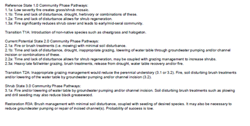
Click on box and path labels to scroll to the respective text.