
Natural Resources
Conservation Service
Ecological site R023XY604OR
ARID PLAINS 8-11 PZ
Last updated: 4/10/2025
Accessed: 05/19/2025
General information
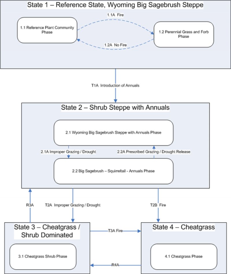
Provisional. A provisional ecological site description has undergone quality control and quality assurance review. It contains a working state and transition model and enough information to identify the ecological site.
Ecological site concept
Currently there is only a draft of the initial concept for this ecological site. The initial concept for this site places it within the Loamy 10-20 PZ Mountain Big Sagebrush and Bluebunch Wheatgrass Ecological Site Group. To view the General STM and other information available for this ESG please go to https://edit.jornada.nmsu.edu/catalogs/esg/023X/R023XY905NV
This site is found on Goodtack and Suckerflat soils. The documented plant community conforms well to the group STM, though range production is only 800lbs/ac.
Table 1. Dominant plant species
Tree |
Not specified |
---|---|
Shrub |
Not specified |
Herbaceous |
Not specified |
Physiographic features
This site occurs on terraces, rolling uplands, and mountain foothills. Slopes typically range from 0 to 20%. Elevations range from 4300 to 5000 feet.
Table 2. Representative physiographic features
Landforms |
(1)
Terrace
|
---|---|
Elevation | 4,300 – 4,500 ft |
Slope | 20% |
Water table depth |
Not specified |
Aspect | Aspect is not a significant factor |
Climatic features
The annual precipitation averages 8 to 11 inches, most of which occurs during the months of October through March. The mean annual air temperature is 48 degrees F. Temperature extremes range from -30 to 110 degrees F. The period for optimum plant growth is from April through early June.
Table 3. Representative climatic features
Frost-free period (average) | |
---|---|
Freeze-free period (average) | |
Precipitation total (average) | 11 in |
Influencing water features
Soil features
The soils of this site are shallow and well-drained. They are formed in lacustrine sediments high in ash over welded tuff or in basalt of lava plains. Soils are moderately permeable and the available water holding capacity is 2 to 5 inches for the profile.
Table 4. Representative soil features
Surface texture |
(1) Stony loam |
---|---|
Family particle size |
(1) Loamy |
Drainage class | Well drained |
Permeability class | Moderate |
Soil depth | Not specified |
Surface fragment cover <=3" | Not specified |
Surface fragment cover >3" | Not specified |
Available water capacity (0-40in) |
2 – 5 in |
Calcium carbonate equivalent (0-40in) |
Not specified |
Electrical conductivity (0-40in) |
Not specified |
Sodium adsorption ratio (0-40in) |
Not specified |
Soil reaction (1:1 water) (0-40in) |
7 |
Subsurface fragment volume <=3" (Depth not specified) |
Not specified |
Subsurface fragment volume >3" (Depth not specified) |
Not specified |
Ecological dynamics
The potential native plant community is dominated by bluebunch wheatgrass and basin big sagebrush. Thurber needlegrass may also form a significant component of the understory. The vegetative composition of the community is approximately 60% grasses, 5% forbs, and 35% shrubs.
Variability in production and composition on a site are a result of variation in the soil depth and texture. In general, bluebunch wheatgrass favors the more clayey soils while Thurber needlegrass will be enhanced by the more coasely textured soils.
Four states have been identified for this site: a reference state; a state with the presence of annuals; a state with a shrub/annual co-dominance; and a state with annual dominance.
Reference: Plant community phase change is driven by infrequent fire. Wyoming and basin big sagebrush decline after fire while Thurber’s needlegrass, Indian ricegrass and other grasses increase. May see a temporary increase in rabbitbrush after fire. Time facilitates the reintroduction of sagebrush. The introduction of invasive annual grasses and forbs transitions into the state 2.
State 2: Compositionally similar to the reference state with a trace of cheatgrass and weedy forbs. Ecological function has not changed, however the resiliency of the state has been reduced by the presence of invasive weeds. Prescribed grazing and infrequent fire (> 50 year return interval) maintain state dynamics. The timing and/or intensity of grazing or prolonged drought favors Wyoming and basin big sagebrush, squirreltail and Sandberg’s bluegrass. Prescribed grazing and/or release from drought may reverse the decline in needlegrass and Indian ricegrass production. Infrequent fire reduces the shrub community and promotes the bunchgrass component. Mismanaged grazing and/or prolonged drought leads to a biotic threshold and into state 3.
State 3: Wyoming and basin big sagebrush is decadent with little recruitment. The perennial grass component is significantly reduced in both density and productivity. Cheatgrass and/or annual forbs and/or Sandberg’s bluegrass along with sagebrush control site resources and drive ecological dynamics. Bare ground is abundant. Spatial and temporal energy capture and nutrient cycling has been truncated. Infiltration may be reduced due to lack of ground cover. Risk of soil erosion by both wind and water is increased. Catastrophic wildfire will lead to an abiotic threshold and into state 4.
State 4: Cheatgrass and/or annual weed dominated plant community with limited to no shrub or perennial grass component. Soil erosion and redistribution along with changes in dynamic soil properties affect the hydrologic cycle and thus the nutrient cycle. Harsh environmental factors increase state resiliency to change.
If the condition of the site deteriorates as a result of overgrazing, bluebunch wheatgrass and Indian ricegrass will decrease while basin big sagebrush and Thurber needlegrass will increase. With further deterioration annuals will invade, Thurber needlegrass will decrease and bottlebrush squirreltail will increase as will the amount of bare ground in the interstitial space.
State and transition model

Figure 1. Group 6, STM
More interactive model formats are also available.
View Interactive Models
Interpretations
Animal community
This site is commonly used by mule deer, pronghorn antelope, rabbits, rodents, an assorted variety of birds and their associated avian and terrestrial predators.
Grazing: This site is suited for use by cattle, sheep, and horses under a planned grazing system in all seasons. Care should be taken if spring use is planned to ensure that soils are sufficiently drained to reduce hoof impacts, and that the plants ae sufficiently established to withstand grazing impacts.
Hydrological functions
The soils of this site have moderately high to high infiltration rates which correspond to a low runoff potential. The hydrologic cover is good when ecological condition is high.
Recreational uses
None
Wood products
This site is susceptible to invasion by western juniper. If this occurs, this site is capable of producing fence posts and firewood.
Supporting information
Contributors
Gene Hickman
Approval
Kendra Moseley, 4/10/2025
Rangeland health reference sheet
Interpreting Indicators of Rangeland Health is a qualitative assessment protocol used to determine ecosystem condition based on benchmark characteristics described in the Reference Sheet. A suite of 17 (or more) indicators are typically considered in an assessment. The ecological site(s) representative of an assessment location must be known prior to applying the protocol and must be verified based on soils and climate. Current plant community cannot be used to identify the ecological site.
Author(s)/participant(s) | |
---|---|
Contact for lead author | |
Date | 04/11/2025 |
Approved by | Kendra Moseley |
Approval date | |
Composition (Indicators 10 and 12) based on | Annual Production |
Indicators
-
Number and extent of rills:
-
Presence of water flow patterns:
-
Number and height of erosional pedestals or terracettes:
-
Bare ground from Ecological Site Description or other studies (rock, litter, lichen, moss, plant canopy are not bare ground):
-
Number of gullies and erosion associated with gullies:
-
Extent of wind scoured, blowouts and/or depositional areas:
-
Amount of litter movement (describe size and distance expected to travel):
-
Soil surface (top few mm) resistance to erosion (stability values are averages - most sites will show a range of values):
-
Soil surface structure and SOM content (include type of structure and A-horizon color and thickness):
-
Effect of community phase composition (relative proportion of different functional groups) and spatial distribution on infiltration and runoff:
-
Presence and thickness of compaction layer (usually none; describe soil profile features which may be mistaken for compaction on this site):
-
Functional/Structural Groups (list in order of descending dominance by above-ground annual-production or live foliar cover using symbols: >>, >, = to indicate much greater than, greater than, and equal to):
Dominant:
Sub-dominant:
Other:
Additional:
-
Amount of plant mortality and decadence (include which functional groups are expected to show mortality or decadence):
-
Average percent litter cover (%) and depth ( in):
-
Expected annual annual-production (this is TOTAL above-ground annual-production, not just forage annual-production):
-
Potential invasive (including noxious) species (native and non-native). List species which BOTH characterize degraded states and have the potential to become a dominant or co-dominant species on the ecological site if their future establishment and growth is not actively controlled by management interventions. Species that become dominant for only one to several years (e.g., short-term response to drought or wildfire) are not invasive plants. Note that unlike other indicators, we are describing what is NOT expected in the reference state for the ecological site:
-
Perennial plant reproductive capability:
Print Options
Sections
Font
Other
The Ecosystem Dynamics Interpretive Tool is an information system framework developed by the USDA-ARS Jornada Experimental Range, USDA Natural Resources Conservation Service, and New Mexico State University.
Click on box and path labels to scroll to the respective text.