
Natural Resources
Conservation Service
Ecological site R023XY061NV
MOUNTAIN SHOULDERS 14-18 P.Z.
Last updated: 4/10/2025
Accessed: 05/20/2025
General information
Provisional. A provisional ecological site description has undergone quality control and quality assurance review. It contains a working state and transition model and enough information to identify the ecological site.
Ecological site concept
Currently there is only a draft of the initial concept for this ecological site. The initial concept for this site places it within the Ashy or Loamy Skeletal Mod Deep 10-20 PZ High-Resilience Mountain Big Sagebrush and Idaho Fescue Ecological Site Group. To view the General STM and other information available for this ESG please go to https://edit.jornada.nmsu.edu/catalogs/esg/023X/R023XY906NV
This site is significantly less productive than the modal site with only 700 lbs/ac in normal years. Soils on this site are shallow and have high amounts of coarse fragments in the soil profile. This community occurs on wind-swept mountain summits and shoulders and tends to have heavy snowpack until late spring. Mountain big sagebrush on this site tends to be low in stature due to these severe environmental conditions. Needlegrasses such as Columbia, western, and Letterman’s are common grasses along with Idaho fescue and bluebunch wheatgrass. Forbs are common. Slopes typically range from 2 to 15 percent, elevations range from 6700 to 8500 feet, and precipitation ranges from 14 to over 18 inches. This site is similar to the group modal site with 2 stable states.
Associated sites
R023XY007NV |
LOAMY 14-16 P.Z. |
---|---|
R023XY008NV |
MOUNTAIN RIDGE |
R023XY019NV |
LOAMY 16+ P.Z. |
R023XY026NV |
MAHOGANY SAVANNA |
Similar sites
R023XY043NV |
GRANITIC SLOPE 14-16 P.Z. FEID-PSSPS codominant grasses |
---|---|
R023XY084NV |
DEEP LOAMY 14-16 P.Z. much more productive site |
R023XY007NV |
LOAMY 14-16 P.Z. FEID-PSSPS, codominant grasses; mountain browse spp. prevalent; more productive site |
R023XY094NV |
ASHY SLOPE 12-14 P.Z. more productive site |
R023XY054NV |
STEEP NORTH SLOPE Steeper slopes; more productive site |
Table 1. Dominant plant species
Tree |
Not specified |
---|---|
Shrub |
(1) Artemisia tridentata var. vaseyana |
Herbaceous |
(1) Festuca idahoensis |
Physiographic features
This site occurs on convex shoulders and summits of mountains and plateaus on all aspects. Slopes range from 4 to over 75 percent, but slope gradients of 8 to 30 percent are most typical. Elevations are 6000 to 8500 feet.
Table 2. Representative physiographic features
Landforms |
(1)
Mountain
|
---|---|
Elevation | 6,000 – 8,500 ft |
Slope | 4 – 75% |
Aspect | Aspect is not a significant factor |
Climatic features
The climate associated with this site is semiarid and characterized by cold, moist winters and warm, dry summers. Average annual precipitation is 14 to over 18 inches. Mean annual air temperature is 38 to 45 degrees F. The average growing season is about 30 to 100 days.
Nevada’s climate is predominantly arid, with large daily ranges of temperature, infrequent severe storms, heavy snowfall in the higher mountains, and great location variations with elevation. Three basic geographical factors largely influence Nevada’s climate: continentality, latitude, and elevation. Continentality is the most important factor. The strong continental effect is expressed in the form of both dryness and large temperature variations. Nevada lies on the eastern, lee side of the Sierra Nevada Range, a massive mountain barrier that markedly influences the climate of the State. The prevailing winds are from the west, and as the warm moist air from the Pacific Ocean ascend the western slopes of the Sierra Range, the air cools, condensation occurs and most of the moisture falls as precipitation. As the air descends the eastern slope, it is warmed by compression, and very little precipitation occurs. The effects of this mountain barrier are felt not only in the West but throughout the state, with the result that the lowlands of Nevada are largely desert or steppes. The temperature regime is also affected by the blocking of the inland-moving maritime air. Nevada sheltered from maritime winds, has a continental climate with well-developed seasons and the terrain responds quickly to changes in solar heating.
Nevada lies within the mid-latitude belt of prevailing westerly winds which occur most of the year. These winds bring frequent changes in weather during the late fall, winter and spring months, when most of the precipitation occurs. To the south of the mid-latitude westerlies, lies a zone of high pressure in subtropical latitudes, with a center over the Pacific Ocean. In the summer, this high-pressure belt shifts northward over the latitudes of Nevada, blocking storms from the ocean. The resulting weather is mostly clear and dry during the summer and early fall, with scattered thundershowers. The eastern portion of the state receives significant summer thunderstorms generated from monsoonal moisture pushed up from the Gulf of California, known as the North American monsoon. The monsoon system peaks in August and by October the monsoon high over the Western U.S. begins to weaken and the precipitation retreats southward towards the tropics (NOAA 2004).
Average annual precipitation is 16 to over 20 inches. Mean annual air temperature is 41 to 44 degrees F. The average growing season is about 50 to 70 days.
Mean annual precipitaion at the Bear Creek, Nevada SNOTEL station (170501020301) is 37.69 inches.
monthly mean precipitation is:
January 3.84; February 3.75; March 4.38; April 4.9;
May 3.99; June 2.82; July .95; August 1.66;
September 1.22; October 2.12;
November 3.67; December 4.38.
Table 3. Representative climatic features
Frost-free period (average) | 65 days |
---|---|
Freeze-free period (average) | |
Precipitation total (average) | 16 in |
Figure 1. Monthly average minimum and maximum temperature
Figure 2. Annual precipitation pattern
Figure 3. Annual average temperature pattern
Influencing water features
There are no influencing water features associated with this site.
Soil features
The soils associated with this site have formed in residuum and colluvium from volcanic rock sources. The low-stature growth form of mountain big sagebrush found on this site is due to a combination of environmental factors: a shallow soil depth, high amounts of coarse fragments in the soil profile, the plant community’s occurrence on wind swept summits and shoulders, and the heavy snow pack that usually remains on these high elevation sites from early winter to late spring. The soil series associated with this site include: Cavid, Croesus, and Westbutte.
Table 4. Representative soil features
Surface texture |
(1) Very gravelly sandy loam (2) Extremely stony loam (3) Very gravelly loam |
---|---|
Family particle size |
(1) Loamy |
Drainage class | Well drained |
Permeability class | Moderate to moderately rapid |
Soil depth | 20 – 84 in |
Surface fragment cover <=3" | 28 – 64% |
Surface fragment cover >3" | 2 – 40% |
Available water capacity (0-40in) |
1.6 – 2.4 in |
Calcium carbonate equivalent (0-40in) |
Not specified |
Electrical conductivity (0-40in) |
Not specified |
Sodium adsorption ratio (0-40in) |
Not specified |
Soil reaction (1:1 water) (0-40in) |
5.6 – 8.4 |
Subsurface fragment volume <=3" (Depth not specified) |
24 – 64% |
Subsurface fragment volume >3" (Depth not specified) |
4 – 39% |
Ecological dynamics
Should management result in abusive use by livestock and/or feral horses, Idaho fescue and needlegrasses will decrease as mountain big sagebrush and other unpalatable shrubs increase in the overstory. Cheatgrass, thistle, and other annuals are plants likely to invade this site.
Fire Ecology:
Presettlement fire return intervals in mountain big sagebrush communities varied from 15 to 25 years. Plants are readily killed in all seasons, even light severity fires. Mountain big sagebrush is highly susceptible to injury from fire. It is often top-killed by fire and will not resprout. Idaho fescue grows in a dense, fine-leaved tuft. Fires tend to burn within the accumulated fine leaves at the base of the plant and may produce temperatures sufficient to kill some of the root crown. Mature Idaho fescue plants are commonly reported to be severely damaged by fire in all seasons. Little specific information is available on adaptations of Letterman's needlegrass to fire. It is morphologically similar to Columbia needlegrass, which is only slightly to moderately damaged by fire. Season of burn affects the plant's ability to survive a fire. Post-fire regeneration is through seeding and tillering. Columbia needlegrass is only slightly to moderately damaged by fire, because it has relatively few culms per clump which may help to minimize the amount of subsurface heat transfer and subsequent damage. Western needlegrass is moderately damaged by fire. The recovery time is between 3 and 5 years. Burning bluebunch wheatgrass may remove most of the aboveground biomass but does not usually result in plant mortality. Bluebunch wheatgrass is generally favored by burning. Burning stimulates flowering and seed production. However, season of burning affects mortality. Cusick’s bluegrass is unharmed to slightly harmed by light-severity fall fires. Cusick’s bluegrass regenerates after fire from seed and by tillering. Sedge is top-killed by fire, with rhizomes protected by insulating soil. The rhizomes of sedge species may be killed by high-severity fires that remove most of the soil organic layer. Reestablishment after fire occurs by seed establishment and/or rhizomatous spread.
State and transition model
More interactive model formats are also available.
View Interactive Models
Click on state and transition labels to scroll to the respective text
Ecosystem states
State 1 submodel, plant communities
State 1
Reference Plant Community
Community 1.1
Reference Plant Community
The reference plant community is dominated by Idaho fescue, and mountain big sagebrush. Letterman's and western needlegrass are important grass species associated with this site. Potential vegetative composition is about 60% grasses, 10% forbs and 30% shrubs. Approximate ground cover (basal and crown) is about 20 to 40 percent.
Figure 4. Annual production by plant type (representative values) or group (midpoint values)
Table 5. Annual production by plant type
Plant type | Low (lb/acre) |
Representative value (lb/acre) |
High (lb/acre) |
---|---|---|---|
Grass/Grasslike | 300 | 420 | 540 |
Shrub/Vine | 150 | 210 | 270 |
Forb | 50 | 70 | 90 |
Total | 500 | 700 | 900 |
Additional community tables
Table 6. Community 1.1 plant community composition
Group | Common name | Symbol | Scientific name | Annual production (lb/acre) | Foliar cover (%) | |
---|---|---|---|---|---|---|
Grass/Grasslike
|
||||||
1 | Primary Perennial Grasses/Grasslikes | 238–511 | ||||
Idaho fescue | FEID | Festuca idahoensis | 140–210 | – | ||
bluebunch wheatgrass | PSSPS | Pseudoroegneria spicata ssp. spicata | 35–105 | – | ||
muttongrass | POFEF | Poa fendleriana ssp. fendleriana | 14–56 | – | ||
Letterman's needlegrass | ACLE9 | Achnatherum lettermanii | 12–35 | – | ||
Columbia needlegrass | ACNEN2 | Achnatherum nelsonii ssp. nelsonii | 12–35 | – | ||
western needlegrass | ACOCO | Achnatherum occidentale ssp. occidentale | 11–35 | – | ||
sedge | CAREX | Carex | 14–35 | – | ||
2 | Secondary Perennial Grasses | 35–70 | ||||
big squirreltail | ELMU3 | Elymus multisetus | 4–14 | – | ||
basin wildrye | LECI4 | Leymus cinereus | 4–14 | – | ||
Forb
|
||||||
3 | Perennial | 35–105 | ||||
arrowleaf balsamroot | BASA3 | Balsamorhiza sagittata | 4–14 | – | ||
tapertip hawksbeard | CRAC2 | Crepis acuminata | 4–14 | – | ||
buckwheat | ERIOG | Eriogonum | 4–14 | – | ||
western stoneseed | LIRU4 | Lithospermum ruderale | 4–14 | – | ||
desertparsley | LOMAT | Lomatium | 4–14 | – | ||
lupine | LUPIN | Lupinus | 4–14 | – | ||
beardtongue | PENST | Penstemon | 4–14 | – | ||
phlox | PHLOX | Phlox | 4–14 | – | ||
mule-ears | WYETH | Wyethia | 4–14 | – | ||
Shrub/Vine
|
||||||
4 | Primary Shrubs | 105–210 | ||||
mountain big sagebrush | ARTRV | Artemisia tridentata ssp. vaseyana | 105–210 | – | ||
5 | Secondary Shrubs | 1–35 | ||||
Utah serviceberry | AMUT | Amelanchier utahensis | 7–14 | – | ||
yellow rabbitbrush | CHVI8 | Chrysothamnus viscidiflorus | 7–14 | – | ||
oceanspray | HOLOD | Holodiscus | 7–14 | – | ||
snowberry | SYMPH | Symphoricarpos | 7–14 | – | ||
spineless horsebrush | TECA2 | Tetradymia canescens | 7–14 | – |
Interpretations
Animal community
Livestock Interpretations:
This site is suitable for livestock grazing. Grazing management should be keyed to perennial grass production. Idaho fescue provides important forage for many types of domestic livestock. The foliage cures well and is preferred by livestock in late fall and winter. Letterman’s needlegrass begins growth early in the year and remains green throughout the relatively long growing season, thus, making it valuable forage for livestock. Columbia needlegrass provides valuable forage for all classes of livestock. Overall production is generally low in the upper sagebrush and mountain brush zones and at the limits of its range where Columbia needlegrass grows only in scattered patches. It is especially valuable to cattle and horses on summer ranges and to domestic sheep on lambing grounds. It is more often cropped closely by cattle and horses than by sheep. Columbia needlegrass is palatable to livestock throughout its range. As with most needlegrasses, it is most palatable early in the season before the foliage becomes coarse and wiry. Palatability to cows and horses is increased because large amounts of fine leafage remain green throughout the growing season. Palatability of Columbia needlegrass is described as fair to good for cattle and horses, becoming nearly unpalatable at maturity. Western needlegrass has a spreading and deeply penetrating root system, which makes it resistant to trampling. Bluebunch wheatgrass is considered one of the most important forage grass species on western rangelands for livestock. Although bluebunch wheatgrass can be a crucial source of forage, it is not necessarily the most highly preferred species. Cusick's bluegrass makes up only a small proportion of the biomass of the sagebrush communities in which it lives, but it is often taken preferentially by cattle, especially early in the season. Sedge provides good to fair forage for domestic grazing. Mountain big sagebrush is eaten by domestic livestock but has long been considered to be of low palatability, and a competitor to more desirable species.
Stocking rates vary over time depending upon season of use, climate variations, site, and previous and current management goals. A safe starting stocking rate is an estimated stocking rate that is fine tuned by the client by adaptive management through the year and from year to year.
Wildlife Interpretations:
Mountain big sagebrush is highly preferred and nutritious winter forage for mule deer and elk. Sagebrush-grassland communities provide critical sage-grouse breeding and nesting habitats. Meadows surrounded by sagebrush may be used as feeding and strutting grounds. Sagebrush is a crucial component of their diet year-round, and sage-grouse select sagebrush almost exclusively for cover. Sage-grouse prefer mountain big sagebrush and Wyoming big sagebrush communities to basin big sagebrush communities. Idaho fescue provides important forge for several wildlife species. It is reported to be good forage for pronghorn, and deer in ranges of northern Nevada. Letterman's needlegrass provides valuable forage for many species of wildlife. It is consumed by mule deer and is most palatable early in the season before the foliage becomes coarse and wiry. Columbia needlegrass provides valuable forage for many species of wildlife. It is also consumed by mule deer and other wildlife species throughout the growing season. Needlegrasses are a significant component in the diet of pocket gophers. Columbia needlegrass is palatable to many species of wildlife throughout its range. As with most needlegrasses, it is most palatable early in the season before the foliage becomes coarse and wiry. Palatability of Columbia needlegrass is described as fair for wildlife overall, becoming nearly unpalatable at maturity. Western needlegrass provides valuable forage for many species of wildlife. Bluebunch wheatgrass is considered one of the most important forage grass species on western rangelands for wildlife. Bluebunch wheatgrass does not generally provide sufficient cover for ungulates, however, mule deer are frequently found in bluebunch-dominated grasslands. Deer, elk, and mountain goat also use Cusick's bluegrass early in the season. The value of Cusick's bluegrass as cover for small animals has been rated as poor to fair. Sedges have a high to moderate resource value for elk and a medium value for mule deer. Elk consume beaked sedge later in the growing season.
Hydrological functions
Runoff is low to medium. Permeability is moderate to moderately rapid. Hydrologic soil group is A and C.
Recreational uses
Aesthetic value is derived from the diverse floral and faunal composition and the colorful flowering of wild flowers and shrubs during the spring and early summer. This site offers rewarding opportunities to photographers and for nature study. This site is used for camping and hiking and has potential for upland and big game hunting.
Other products
Native Americans used big sagebrush leaves and branches for medicinal teas, and the leaves as a fumigant. Bark was woven into mats, bags and clothing.
Other information
Letterman’s needlegrass has been used successfully in revegetating mine spoils. This species also has good potential for erosion control.
Supporting information
Type locality
Location 1: Washoe County, NV | |
---|---|
Township/Range/Section | T36N R22E S6 |
UTM zone | N |
UTM northing | 285623 |
UTM easting | 4545174 |
Latitude | 41° 1′ 46″ |
Longitude | 119° 33′ 0″ |
General legal description | SW 1/4 SW 1/4, Fox Mountian, southeast aspect about 400 feet east of microwave station, Washoe County, Nevada. |
Other references
Fire Effects Information System (Online; http://www.fs.fed.us/database/feis/plants/).
USDA-NRCS Plants Database (Online; http://www.plants.usda.gov).
Contributors
LB/CP
T Stringham (UNR under contract with BLM)
Approval
Kendra Moseley, 4/10/2025
Rangeland health reference sheet
Interpreting Indicators of Rangeland Health is a qualitative assessment protocol used to determine ecosystem condition based on benchmark characteristics described in the Reference Sheet. A suite of 17 (or more) indicators are typically considered in an assessment. The ecological site(s) representative of an assessment location must be known prior to applying the protocol and must be verified based on soils and climate. Current plant community cannot be used to identify the ecological site.
Author(s)/participant(s) | |
---|---|
Contact for lead author | |
Date | 04/11/2025 |
Approved by | Kendra Moseley |
Approval date | |
Composition (Indicators 10 and 12) based on | Annual Production |
Indicators
-
Number and extent of rills:
-
Presence of water flow patterns:
-
Number and height of erosional pedestals or terracettes:
-
Bare ground from Ecological Site Description or other studies (rock, litter, lichen, moss, plant canopy are not bare ground):
-
Number of gullies and erosion associated with gullies:
-
Extent of wind scoured, blowouts and/or depositional areas:
-
Amount of litter movement (describe size and distance expected to travel):
-
Soil surface (top few mm) resistance to erosion (stability values are averages - most sites will show a range of values):
-
Soil surface structure and SOM content (include type of structure and A-horizon color and thickness):
-
Effect of community phase composition (relative proportion of different functional groups) and spatial distribution on infiltration and runoff:
-
Presence and thickness of compaction layer (usually none; describe soil profile features which may be mistaken for compaction on this site):
-
Functional/Structural Groups (list in order of descending dominance by above-ground annual-production or live foliar cover using symbols: >>, >, = to indicate much greater than, greater than, and equal to):
Dominant:
Sub-dominant:
Other:
Additional:
-
Amount of plant mortality and decadence (include which functional groups are expected to show mortality or decadence):
-
Average percent litter cover (%) and depth ( in):
-
Expected annual annual-production (this is TOTAL above-ground annual-production, not just forage annual-production):
-
Potential invasive (including noxious) species (native and non-native). List species which BOTH characterize degraded states and have the potential to become a dominant or co-dominant species on the ecological site if their future establishment and growth is not actively controlled by management interventions. Species that become dominant for only one to several years (e.g., short-term response to drought or wildfire) are not invasive plants. Note that unlike other indicators, we are describing what is NOT expected in the reference state for the ecological site:
-
Perennial plant reproductive capability:
Print Options
Sections
Font
Other
The Ecosystem Dynamics Interpretive Tool is an information system framework developed by the USDA-ARS Jornada Experimental Range, USDA Natural Resources Conservation Service, and New Mexico State University.
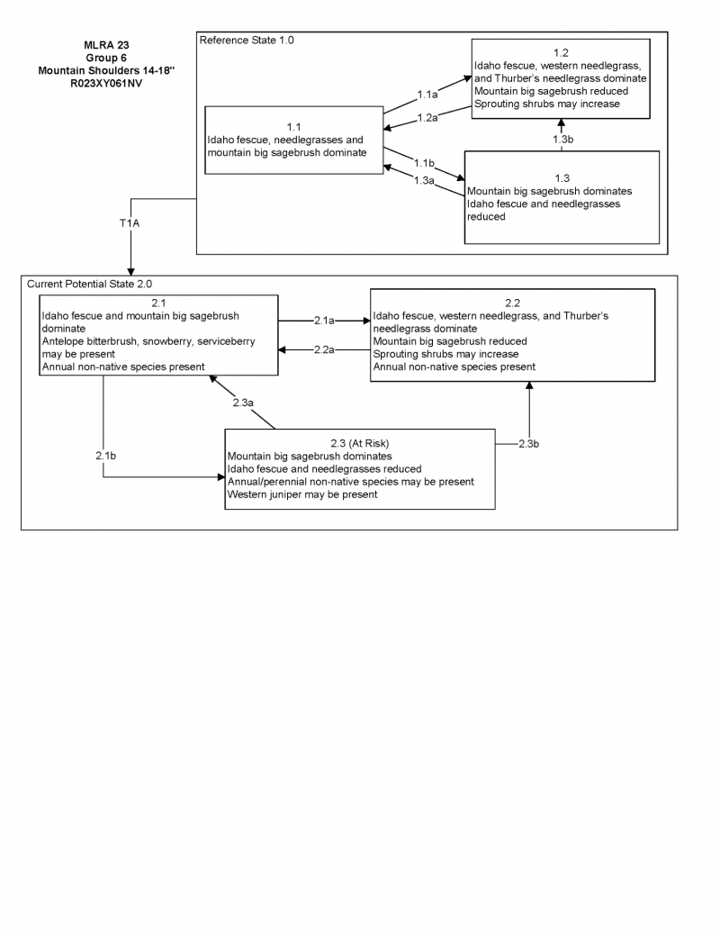
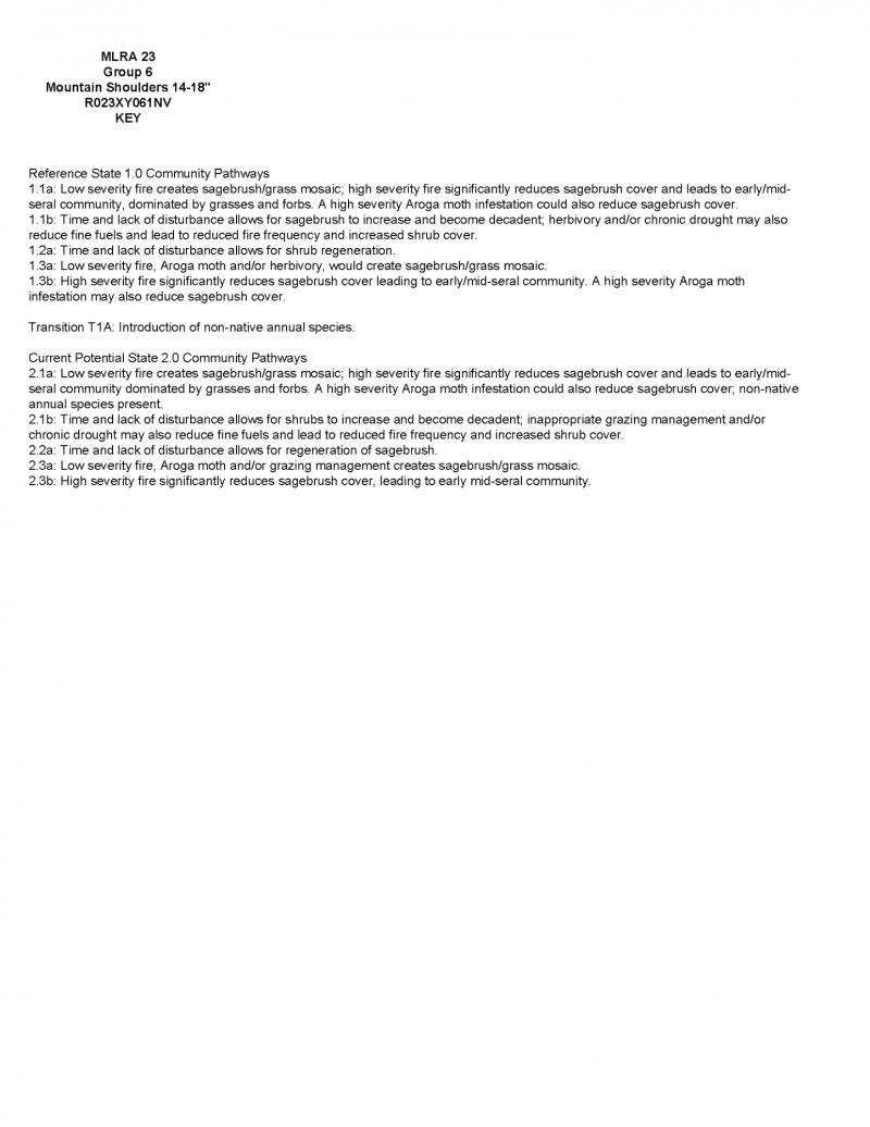
Click on box and path labels to scroll to the respective text.