Natural Resources
Conservation Service
Ecological site R023XY022NV
WELL DRAINED FAN 12-14 P.Z.
Last updated: 4/10/2025
Accessed: 05/20/2025
General information
Provisional. A provisional ecological site description has undergone quality control and quality assurance review. It contains a working state and transition model and enough information to identify the ecological site.
Ecological site concept
Currently there is only a draft of the initial concept for this ecological site. The initial concept for this site places it within the Loamy 10-20 PZ Mountain Big Sagebrush and Bluebunch Wheatgrass Ecological Site Group. To view the General STM and other information available for this ESG please go to https://edit.jornada.nmsu.edu/catalogs/esg/023X/R023XY905NV
This site is slightly less productive with 1100 lbs/ac in normal years. Slopes typically range from 2 to 15 percent. Soils are medium textured with moderate to high available water holding capacity. Potential for sheet and rill erosion is moderate. Unlike the modal site, antelope bitterbrush codominates with basin big sagebrush and/or mountain big sagebrush. This site has four states (no tree state).
Associated sites
| R023XY020NV |
LOAMY 10-12 P.Z. |
|---|---|
| R023XY031NV |
CLAYPAN 10-14 P.Z. |
Similar sites
| R023XY007NV |
LOAMY 14-16 P.Z. FEID-PSSPS codominant; ARTRV only sagebrush spp. |
|---|---|
| R023XY039NV |
LOAMY SLOPE 10-14 P.Z. PSSPS dominant grass; less productive site |
| R023XY098NV |
DEEP LOAMY 10-12 P.Z. PERA4 codominant shrub |
| R023XY041NV |
LOAMY 12-14 P.Z. PSSPS-LECIE4 codominant grasses |
| R023XY020NV |
LOAMY 10-12 P.Z. PSSPS-ACTH7 codominant; less productive site |
Table 1. Dominant plant species
| Tree |
Not specified |
|---|---|
| Shrub |
(1) Purshia tridentata |
| Herbaceous |
(1) Pseudoroegneria spicata ssp. spicata |
Physiographic features
This site occurs on stream terraces cut into interplateau basins. Slopes range from 2 to 4 percent. Elevations are 5620 to 5680 feet.
Table 2. Representative physiographic features
| Landforms |
(1)
Stream terrace
|
|---|---|
| Elevation | 5,620 – 5,680 ft |
| Slope | 2 – 4% |
| Aspect | Aspect is not a significant factor |
Climatic features
The climate associated with this site is semiarid and characterized by cool, moist winters and warm, dry summers. Average annual precipitation is 12 to 14 inches. Mean annual air temperature is 43º to 47º F. The average growing season is about 50 to 90 days.
Nevada’s climate is predominantly arid, with large daily ranges of temperature, infrequent severe storms, heavy snowfall in the higher mountains, and great location variations with elevation. Three basic geographical factors largely influence Nevada’s climate: continentality, latitude, and elevation. Continentality is the most important factor. The strong continental effect is expressed in the form of both dryness and large temperature variations. Nevada lies on the eastern, lee side of the Sierra Nevada Range, a massive mountain barrier that markedly influences the climate of the State. The prevailing winds are from the west, and as the warm moist air from the Pacific Ocean ascend the western slopes of the Sierra Range, the air cools, condensation occurs and most of the moisture falls as precipitation. As the air descends the eastern slope, it is warmed by compression, and very little precipitation occurs. The effects of this mountain barrier are felt not only in the West but throughout the state, with the result that the lowlands of Nevada are largely desert or steppes. The temperature regime is also affected by the blocking of the inland-moving maritime air. Nevada sheltered from maritime winds, has a continental climate with well-developed seasons and the terrain responds quickly to changes in solar heating.
Nevada lies within the mid-latitude belt of prevailing westerly winds which occur most of the year. These winds bring frequent changes in weather during the late fall, winter and spring months, when most of the precipitation occurs. To the south of the mid-latitude westerlies, lies a zone of high pressure in subtropical latitudes, with a center over the Pacific Ocean. In the summer, this high-pressure belt shifts northward over the latitudes of Nevada, blocking storms from the ocean. The resulting weather is mostly clear and dry during the summer and early fall, with scattered thundershowers. The eastern portion of the state receives significant summer thunderstorms generated from monsoonal moisture pushed up from the Gulf of California, known as the North American monsoon. The monsoon system peaks in August and by October the monsoon high over the Western U.S. begins to weaken and the precipitation retreats southward towards the tropics (NOAA 2004).
Average annual precipitation is 16 to over 20 inches. Mean annual air temperature is 41 to 44 degrees F. The average growing season is about 50 to 70 days.
Mean annual precipitaion at the Bear Creek, Nevada SNOTEL station (170501020301) is 37.69 inches.
monthly mean precipitation is:
January 3.84; February 3.75; March 4.38; April 4.9;
May 3.99; June 2.82; July .95; August 1.66;
September 1.22; October 2.12;
November 3.67; December 4.38.
Table 3. Representative climatic features
| Frost-free period (average) | 70 days |
|---|---|
| Freeze-free period (average) | |
| Precipitation total (average) | 13 in |
Figure 1. Monthly precipitation range
Figure 2. Monthly average minimum and maximum temperature
Figure 3. Annual precipitation pattern
Figure 4. Annual average temperature pattern
Influencing water features
There are no influencing water features associated with this site.
Soil features
The soils associated with this site have formed in mixed alluvium from volcanic rock sources. The soils are very deep, well drained, and often have gravel strata interspersed through the soil profile. Soils are medium textured with moderate to high available water holding capacity. Potential for sheet and rill erosion is moderate. The soils associated with this site are classified as Torrifluventic Haploxerolls.
Table 4. Representative soil features
| Family particle size |
(1) Loamy |
|---|---|
| Drainage class | Well drained |
| Permeability class | Moderately slow |
| Soil depth | 72 – 84 in |
| Available water capacity (0-40in) |
Not specified |
| Calcium carbonate equivalent (0-40in) |
Not specified |
| Electrical conductivity (0-40in) |
Not specified |
| Sodium adsorption ratio (0-40in) |
Not specified |
| Soil reaction (1:1 water) (0-40in) |
6.1 – 7.3 |
Ecological dynamics
Where management results in abusive grazing use by livestock and/or feral horses, mountain big sagebrush and rabbitbrush will increase at the expense of Thurber’s needlegrass and bluebunch wheatgrass. Moderate to heavy sheep use of this site will decrease abundance of Thurber’s needlegrass and bluegrasses. Heavy, early season, cattle or horse use will decrease bluebunch wheatgrass composition in the community. Although late summer-fall use by cattle can impact bitterbrush seeling establishment, cattle use at this time can be managed to maintain a growth form that makes leaf and stem production of bitterbrush more available to big game animals. In the absence of natural fire, western juniper readily invades this site. Cheatgrass and thistle are plant species most likely to invade this site.
Fire Ecology:
Presettlement fire return intervals for antelope bitterbrush communities range from 15 to 25 years. Season of burning and environmental conditions have a large impact on antelope bitterbrush ability to survive fire and sprout. Antelope bitterbrush is considered a weak sprouter and is often killed by summer or fall fire. Antelope bitterbrush in some areas may sprout after light-severity spring fire. High fuel consumptions increase antelope bitterbrush mortality and therefore favors seedling establishment. Basin big sagebrush is readily killed when aboveground plant parts are charred by fire. Prolific seed production from nearby unburned plants coupled with high germination rates enables seedlings to establish rapidly following fire. Burning bluebunch wheatgrass may remove most of the aboveground biomass but does not usually result in plant mortality. Bluebunch wheatgrass is generally favored by burning. Burning stimulates flowering and seed production. However, season of burning affects mortality. Thurber’s needlegrass is classified as moderately resistant, but depending on season of burn, phenology, and fire severity, this perennial bunchgrass is moderately to severely damaged by fire. Early season burning is more damaging to this needlegrass than late season burning. Canby's bluegrass is generally unharmed by fire. It produces little litter, and its small bunch size and sparse litter reduces the amount of heat transferred to perennating buds in the soil. Its rapid maturation in the spring also reduces fire damage, since it is dormant when most fires occur.
State and transition model
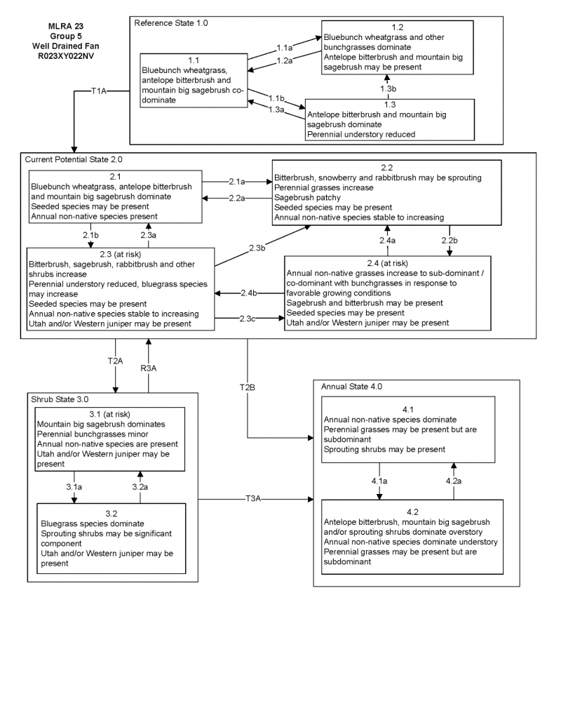

More interactive model formats are also available.
View Interactive Models
Click on state and transition labels to scroll to the respective text
Ecosystem states
State 1 submodel, plant communities
State 1
Reference Plant Community
Community 1.1
Reference Plant Community
The reference plant community is dominated by bluebunch wheatgrass, antelope bitterbrush, and big sagebrush. Potential vegetative composition is about 60% grasses, 10% forbs, and 30% shrubs and trees. Approximate ground cover (basal and crown) is about 30 to 40 percent.
Figure 5. Annual production by plant type (representative values) or group (midpoint values)
Table 5. Annual production by plant type
| Plant type | Low (lb/acre) |
Representative value (lb/acre) |
High (lb/acre) |
|---|---|---|---|
| Grass/Grasslike | 540 | 660 | 840 |
| Shrub/Vine | 252 | 308 | 392 |
| Forb | 90 | 110 | 140 |
| Tree | 18 | 22 | 28 |
| Total | 900 | 1100 | 1400 |
Additional community tables
Table 6. Community 1.1 plant community composition
| Group | Common name | Symbol | Scientific name | Annual production (lb/acre) | Foliar cover (%) | |
|---|---|---|---|---|---|---|
|
Grass/Grasslike
|
||||||
| 1 | Primary Perennial Grasses | 407–660 | ||||
| bluebunch wheatgrass | PSSPS | Pseudoroegneria spicata ssp. spicata | 330–440 | – | ||
| Thurber's needlegrass | ACTH7 | Achnatherum thurberianum | 55–165 | – | ||
| 2 | Secondary Perennial Grasses/Grasslikes | 22–55 | ||||
| Indian ricegrass | ACHY | Achnatherum hymenoides | 6–22 | – | ||
| sedge | CAREX | Carex | 6–22 | – | ||
| squirreltail | ELEL5 | Elymus elymoides | 6–22 | – | ||
| Idaho fescue | FEID | Festuca idahoensis | 6–22 | – | ||
| prairie Junegrass | KOMA | Koeleria macrantha | 6–22 | – | ||
| basin wildrye | LECI4 | Leymus cinereus | 6–22 | – | ||
|
Forb
|
||||||
| 3 | Perennial | 55–165 | ||||
| arrowleaf balsamroot | BASA3 | Balsamorhiza sagittata | 6–33 | – | ||
| tapertip hawksbeard | CRAC2 | Crepis acuminata | 6–33 | – | ||
| lupine | LUPIN | Lupinus | 6–33 | – | ||
| phlox | PHLOX | Phlox | 6–33 | – | ||
|
Shrub/Vine
|
||||||
| 4 | Primary Shrub | 165–440 | ||||
| antelope bitterbrush | PUTR2 | Purshia tridentata | 110–220 | – | ||
| basin big sagebrush | ARTRT | Artemisia tridentata ssp. tridentata | 28–110 | – | ||
| mountain big sagebrush | ARTRV | Artemisia tridentata ssp. vaseyana | 27–110 | – | ||
| 5 | Secondary Shrub | 22–55 | ||||
| Utah serviceberry | AMUT | Amelanchier utahensis | 11–22 | – | ||
| yellow rabbitbrush | CHVI8 | Chrysothamnus viscidiflorus | 11–22 | – | ||
|
Tree
|
||||||
| 6 | Evergreen | 6–22 | ||||
| western juniper | JUOC | Juniperus occidentalis | 6–22 | – | ||
Interpretations
Animal community
Livestock Interpretations:
This site is suitable for livestock grazing. Grazing management should be keyed to perennial grass production. Bluebunch wheatgrass is considered one of the most important forage grass species on western rangelands for livestock. Although bluebunch wheatgrass can be a crucial source of forage, it is not necessarily the most highly preferred species. Thurber’s needlegrass species begin growth early in the year and remain green throughout a relatively long growing season. This pattern of development enables animals to use Thurber’s needlegrass when many other grasses are unavailable. Cattle prefer Thurber’s needlegrass in early spring before fruits have developed as it becomes less palatable when mature. Thurber’s needlegrasses are grazed in the fall only if the fruits are softened by rain. Canby's bluegrass is a widespread forage grass. It is one of the earliest grasses in the spring and is sought by domestic livestock and several wildlife species. Canby's bluegrass is a palatable species, but its production is closely tied to weather conditions. It produces little forage in drought years, making it a less dependable food source than other perennial bunchgrasses. Antelope bitterbrush is important browse for livestock. Domestic livestock and mule deer may compete for antelope bitterbrush in late summer, fall, and/or winter. Cattle prefer antelope bitterbrush from mid-May through June and again in September and October. Basin big sagebrush may serve as emergency food during severe winter weather, but it is not usually sought out by livestock. Mountain big sagebrush is eaten by domestic livestock but has long been considered to be of low palatability, and a competitor to more desirable species.
Stocking rates vary over time depending upon season of use, climate variations, site, and previous and current management goals. A safe starting stocking rate is an estimated stocking rate that is fine tuned by the client by adaptive management through the year and from year to year.
Wildlife Interpretations:
Pronghorn antelope, mule deer, elk, and bighorn sheep utilize antelope bitterbrush extensively. Mule deer use of antelope bitterbrush peaks in September, when antelope bitterbrush may compose 91 percent of the diet. Winter use is greatest during periods of deep snow. Antelope bitterbrush seed is a large part of the diets of rodents, especially deer mice and kangaroo rats. Basin big sagebrush is the least palatable of all the subspecies of big sagebrush. Basin big sagebrush is browsed by mule deer from fall to early spring, but is not preferred. Mountain big sagebrush is highly preferred and nutritious winter forage for mule deer and elk. Sagebrush-grassland communities provide critical sage-grouse breeding and nesting habitats. Meadows surrounded by sagebrush may be used as feeding and strutting grounds. Sagebrush is a crucial component of their diet year-round, and sage-grouse select sagebrush almost exclusively for cover. Sage-grouse prefer mountain big sagebrush and Wyoming big sagebrush communities to basin big sagebrush communities. Bluebunch wheatgrass is considered one of the most important forage grass species on western rangelands for wildlife. Bluebunch wheatgrass does not generally provide sufficient cover for ungulates, however, mule deer are frequently found in bluebunch-dominated grasslands. Thurber needlegrass is valuable forage for wildlife. Canby's bluegrass is desirable for pronghorn antelope and mule deer in the spring and preferable in the spring, summer, and fall for elk and desirable as part of their winter range.
Recreational uses
Aesthetic value is derived from the diverse floral and faunal composition and the colorful flowering of wild flowers and shrubs during the spring and early summer. This site offers rewarding opportunities to photographers and for nature study. This site is used for camping and hiking and has potential for upland and big game hunting.
Other products
Some Native American peoples used the bark of big sagebrush to make rope and baskets. Native Americans used big sagebrush leaves and branches for medicinal teas, and the leaves as a fumigant. Bark was woven into mats, bags and clothing.
Other information
Antelope bitterbrush has been used extensively in land reclamation. Antelope bitterbrush enhances succession by retaining soil and depositing organic material and in some habitats and with some ecotypes, by fixing nitrogen. Basin big sagebrush shows high potential for range restoration and soil stabilization. Basin big sagebrush grows rapidly and spreads readily from seed.
Supporting information
Type locality
| Location 1: Modoc County, CA | |
|---|---|
| Township/Range/Section | T42N R16E S18 |
| UTM zone | N |
| UTM northing | 733656 |
| UTM easting | 4598876 |
| Latitude | 41° 30′ 26″ |
| Longitude | 120° 12′ 1″ |
| General legal description | Approximately 2 miles southwest of Cedarville, Deep Creek area, Modoc County, California. This site also occurs in Wahoe County, Nevada. |
Other references
Fire Effects Information System (Online; http://www.fs.fed.us/database/feis/plants/).
USDA-NRCS Plants Database (Online; http://www.plants.usda.gov).
Contributors
BH/SW
T Stringham (UNR under contract with BLM)
Approval
Kendra Moseley, 4/10/2025
Rangeland health reference sheet
Interpreting Indicators of Rangeland Health is a qualitative assessment protocol used to determine ecosystem condition based on benchmark characteristics described in the Reference Sheet. A suite of 17 (or more) indicators are typically considered in an assessment. The ecological site(s) representative of an assessment location must be known prior to applying the protocol and must be verified based on soils and climate. Current plant community cannot be used to identify the ecological site.
| Author(s)/participant(s) | |
|---|---|
| Contact for lead author | |
| Date | 04/11/2025 |
| Approved by | Kendra Moseley |
| Approval date | |
| Composition (Indicators 10 and 12) based on | Annual Production |
Indicators
-
Number and extent of rills:
-
Presence of water flow patterns:
-
Number and height of erosional pedestals or terracettes:
-
Bare ground from Ecological Site Description or other studies (rock, litter, lichen, moss, plant canopy are not bare ground):
-
Number of gullies and erosion associated with gullies:
-
Extent of wind scoured, blowouts and/or depositional areas:
-
Amount of litter movement (describe size and distance expected to travel):
-
Soil surface (top few mm) resistance to erosion (stability values are averages - most sites will show a range of values):
-
Soil surface structure and SOM content (include type of structure and A-horizon color and thickness):
-
Effect of community phase composition (relative proportion of different functional groups) and spatial distribution on infiltration and runoff:
-
Presence and thickness of compaction layer (usually none; describe soil profile features which may be mistaken for compaction on this site):
-
Functional/Structural Groups (list in order of descending dominance by above-ground annual-production or live foliar cover using symbols: >>, >, = to indicate much greater than, greater than, and equal to):
Dominant:
Sub-dominant:
Other:
Additional:
-
Amount of plant mortality and decadence (include which functional groups are expected to show mortality or decadence):
-
Average percent litter cover (%) and depth ( in):
-
Expected annual annual-production (this is TOTAL above-ground annual-production, not just forage annual-production):
-
Potential invasive (including noxious) species (native and non-native). List species which BOTH characterize degraded states and have the potential to become a dominant or co-dominant species on the ecological site if their future establishment and growth is not actively controlled by management interventions. Species that become dominant for only one to several years (e.g., short-term response to drought or wildfire) are not invasive plants. Note that unlike other indicators, we are describing what is NOT expected in the reference state for the ecological site:
-
Perennial plant reproductive capability:
Print Options
Sections
Font
Other
The Ecosystem Dynamics Interpretive Tool is an information system framework developed by the USDA-ARS Jornada Experimental Range, USDA Natural Resources Conservation Service, and New Mexico State University.
Click on box and path labels to scroll to the respective text.