
Natural Resources
Conservation Service
Ecological site F225XY315AK
Southern Alaska Forest Loamy Terraces
Last updated: 6/14/2025
Accessed: 10/19/2025
General information
Provisional. A provisional ecological site description has undergone quality control and quality assurance review. It contains a working state and transition model and enough information to identify the ecological site.
MLRA notes
Major Land Resource Area (MLRA): 225X–Southern Alaska Peninsula Mountains
Major Land Resource Area 225X (Southern Alaska Peninsula Mountains), herein called area, is in the Southern Alaska Land Resource Region (LRR). MLRA 225X covers approximately 23,935 square miles of the southern parts of the Kodiak Archipelago and the slopes of the southern Aleutian Mountains on the Alaska Peninsula. The landscape is comprised of rugged mountains separated by narrow valleys, with outwash plains and low hills towards the coast. Glaciers and ice fields cover the highest mountains. Flood plains are predominantly restricted to broad river valleys. Elevations range from sea level to 9,372 feet at the summit of Shishaldin Volcano. The soils and vegetation in this MLRA have been influenced by ash deposits from nearby Mount Katmai and surrounding volcanoes. This MLRA is primarily comprised of wilderness, with towns and villages primarily located along rivers, lakes, and the coast. Small villages are scattered along the coastline and include King Cove, Old Harbor, Karluk, and Larsen Bay among others. There is no road access to MLRA 225X from Anchorage, AK, and access is primarily via plane or boat.
MLRA 225X, excluding high peaks and steep upper backslopes, was glaciated during the Late Pleistocene. Glacial deposits were eroded or covered by colluvium or alluvium during the Holocene, which comprises 60 percent of the current landscape. Modified glacial moraines and outwash landforms are prevalent. Volcanic activity continues through the present day, and ash deposits are represented in many of the soils of this MLRA.
The dominant soil orders are Andisols, Histosols, and Inceptisols. Soils have a cryic temperature regime or subgelic soil temperature class, an aquic or udic soil moisture regime, and primarily amorphic mineralogy. Permafrost is sporadic in the Southern Alaska LRR. The primary soils in this MLRA developed from volcanic ash over colluvium or from thick organic material. Miscellaneous (non-soil) areas comprise greater than 50 percent of all acreage in this MLRA and includes “rock outcrops, rubble land, glaciers, riverwash, and beaches” (USDA-NRCS, 2022).
The climate in this MLRA is shaped by maritime influences from Bristol Bay to the west and the Pacific Ocean to the south. Mountains effect local patterns in temperature and precipitation. Temperatures are typically cool throughout the year. The mean annual temperature at sea level is 37 to 43 degrees Fahrenheit. Precipitation ranges from 30 inches along the coast to over 100 inches at high elevations. Snowfall ranges from 50 to 200 inches and glaciers and icefields are present at higher elevations.
This MLRA is dominated by tall alder and willow shrubs at lower elevations. Vegetation shifts to low and then dwarf shrubs at increased elevations. Herbaceous communities are on exposed plains and hills, and sedges dominate wet depressions. Balsam poplar forests are restricted to flood plains and warm, low mountain slopes in the northern parts of the MLRA (USDA-NRCS, 2022).
LRU notes
MLRA 225X supports three life zones delineated by the physiological limits of plant communities along longitudinal and elevational gradients: Aleutian, South Alaska maritime, and South Alaska alpine. The Aleutian climate covers hills of the southern Kodiak archipelago and on the extended Alaska Peninsula. These regions are low-lying, exposed and are scoured by winter winds. Vegetation is primarily low shrublands, heathlands and often diverse herbaceous meadows. The South Alaska maritime climate is common in mountainous areas where local site conditions delineate alpine and lowland areas. Certain vascular plant species are common in the lowlands and much less common in the alpine (i.e. Populus balsamifera, Alnus spp., Salix pulchra, Betula nana, Ledum palustre ssp. decumbens, and Calamagrostis canadensis). The alpine generally occurs at elevations above 1,500 feet, though may extend higher on warm, north-facing slopes, and lower on cooler slopes. Vascular plants are restricted in height and often exclude common lowland species. The transition between South Alaska maritime and alpine vegetation can occur within a range of elevations, and is highly dependent on latitude, slope, aspect, and shading from adjacent mountains.
Classification relationships
Landfire Biophysical Settings – 7616420 – Aleutian Kenai Birch-Cottonwood-Poplar Forest (Landfire, 2009)
Circumboreal Vegetation map (CBVM) – Southern Alaska Floodplain Spruce-Cottonwood Forests and Scrub (Jorgensen and Meidinger, 2015)
Viereck Communities:
Level III - Closed broadleaf forest (I.B.1) / Level IV – Black cottonwood closed forest (I.B.1.b)
(Viereck et al., 1992)
Kodiak Archipelago Land Cover Classification:
Class 11 – Dense cottonwood forest
Class 55 – Open-sparse cottonwood forest
(Fleming and Spencer, 2007)
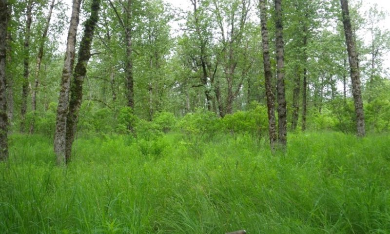
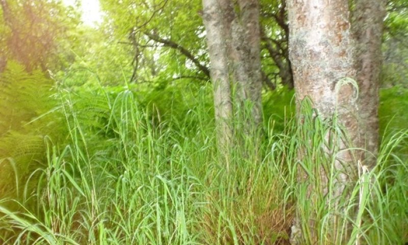
Ecological site concept
Ecological Site concept:
• Occurs on river valley terraces
• The reference plant community is a closed broadleaf forest (Viereck et al., 1992)
• Soils comprised of volcanic ash or loess atop outwash material
• Soils are well drained
• This ecological site is stable. Flooding does not occur. Trees are susceptible to wind throw.
Associated sites
| F225XY310AK |
Southern Alaska Riparian Complex Flood Plains Forested riparian complex in mountain river valleys. |
|---|---|
| R225XY313AK |
Southern Alaska Scrub Loamy Oxbows Oxbows on flood plains |
| F225XY360AK |
Southern Alaska Forest Loamy Hill Backslopes Forest on lower mountain slopes. |
| R225XY363AK |
Southern Alaska Scrub Loamy Hill Backslope Higher elevation scrublands on hill backslopes with bedrock-restricted soils. |
Similar sites
| F225XY310AK |
Southern Alaska Riparian Complex Flood Plains R225XY310AK is the riparian complex on flood plains, which are shaped by alluvial processes not associated with this ecological site. |
|---|---|
| F225XY360AK |
Southern Alaska Forest Loamy Hill Backslopes R225XY360AK describes deciduous forests on low mountain slopes. |
Table 1. Dominant plant species
| Tree |
(1) Populus balsamifera |
|---|---|
| Shrub |
(1) Salix barclayi |
| Herbaceous |
(1) Calamagrostis canadensis |
Click on box and path labels to scroll to the respective text.