Natural Resources
Conservation Service
Ecological site QX192X01X501
Somewhat Poorly Drained Alluvium
Last updated: 5/08/2025
Accessed: 10/19/2025
General information
Provisional. A provisional ecological site description has undergone quality control and quality assurance review. It contains a working state and transition model and enough information to identify the ecological site.
MLRA notes
Major Land Resource Area (MLRA): 192X–Volcanic Highlands of the Mariana Islands
This MLRA is in the southern half of Guam. Topography consists of mountains and plateaus that are dissected by streams. The highest elevation is 1,336 feet (410 centimeters). The geology consists of deeply weathered volcanic rock with some limestone inclusions. Average annual rainfall ranges from 85 to 100 inches (2,160 to 2,540 millimeters) in the northern half of this MLRA and from 95 to 118 inches (2,410 to 3,000 millimeters) in the southern half. Average annual temperature is 79 degrees F (26 degrees C). The dry season occurs from January through April, the rainy season occurs from July through November. Trade winds are persistent during the dry season. Typhoons are frequent. Soils are Entisols, Alfisols, Inceptisols, Mollisols, or Oxisols. The dominant soil moisture regime is ustic. The soil temperature regime is isohyperthermic. Except for remnants of native forest in gulches and river valleys, forest vegetation has been largely replaced by grasses through repeated burning. Introduced deer, pigs, goats, and water buffalo are common (USDA-NRCS, 2006).
Classification relationships
This ecological site occurs within Major Land Resource Area (MLRA) 192 – Volcanic Islands of the Mariana Islands.
Ecological site concept
This ecological site occurs on the island of Guam in the Mariana Islands. It occurs on nearly level to moderately sloping (0 to 15 percent slopes) hillslopes in steeps, narrow stream channels, and depressions at elevations ranging from 33 to 984 feet (10 to 300 meters) (USDA- SCS, 1988).
Soils are very deep, somewhat poorly drained Entisols (Aquic Ustifluvents) that formed in alluvium derived from weathered tuff and tuff breccia (USDA-SCS, 1988). Soil temperature regimes are isohyperthermic; soil moisture regimes are ustic with an aquic intergrade, meaning water tables are high except during the distinct dry season. Mean annual precipitation is about 101 inches (2,565 millimeters) (PRISM, 2006). Water runoff is low to medium; permeability is slow (USDA-SCS, 1988). The water table in the rainy season is at a depth of 30 inches (75 centimeters). As such the effective rooting depth is about 30 inches (75 centimeters). Flooding is rare and brief in the rainy season. Available water-holding capacity is moderate (7 inches). pH is strongly acidic to moderately acidic (5.3 to 5.8). Groundwater is fresh (electronic conductivity is 0.0 dS/cm). Most of the area is vegetated by wetland forest, grasses, and sedges (Amidon et al., 2017; Fosberg, 1960; Marshall et al., 2020; Stemmermann, 1981; Stone, 1970; Wagner and Grether, 1948; Willsey et al., 2019).
Associated sites
| QX192X01X003 |
Shallow Soils on Volcanic Uplands Soils of QX192X01X003 (The Shallow Soils on Volcanic Uplands Ecological Site) occur on steeper slopes surrounding QX192X01X501 (The Somewhat Poorly Drained Alluvium Ecological Site), which occurs downslope in depressions, stream channels, and seeps. Water will move from QX192X01X003, which has slow permeability and low to medium runoff, into QX192X01X501. Soils of QX192X01X003 have effective rooting depths of about 0 to 14 inches, very low available water holding capacity (2 inches), neutral soils reactions (6.7), are a very deep-water table, and support upland grasses, forbs, and forest. Soils QX192X01X501 have effective rooting depths greater than 72 inches, moderate water holding capacity (7 inches), moderately acidic to strongly acidic soil reactions (5.3 to 5.8), and have a water table as shallow as 30 inches below the surface, occasional and brief flooding, and support wetland forest, grasses, and sedges. |
|---|---|
| QX192X01X001 |
Moderately Deep Oxic Soils on Volcanic Uplands Soils of QX192X01X001 (The Moderately Deep Oxic Soils on Volcanic Uplands Ecological Site) occur on steeper slopes surrounding QX192X01X501 (The Somewhat Poorly Drained Alluvium Ecological Site), which occurs downslope in depressions, stream channels, and seeps. Water will move from QX192X01X001, which has slow permeability and low to high runoff, into this ecological site, carrying eroded alluvium that forms the parent material of QX192X01X501. Soils of QX192X01X001 have a very deep-water table, low available water holding capacity (3 inches), very strongly acidic to strongly acidic soil reaction (4.9 to 5.1), and high aluminum toxicity such that this site mostly and support mostly Pacific Island silvergrass (swordgrass). While soils of QX192X01X501 have moderate water holding capacity (7), are moderately acidic to strongly acidic (5.3 to 5.8), and have a water table as shallow as 30 inches below the surface, rare and brief flooding, and support wetland forest, grasses, and sedges. |
| QX191X01X506 |
Somewhat Poorly and Poorly Drained Valley Bottoms and Coastal Plains Soils of QX191X01X506 (The Somewhat Poorly and Poorly Drained Valleys and Alluvial Coastal Plains Ecological Site) occur in lower areas and broader valleys than QX191X01X501 (The Somewhat Poorly Drained Alluvium Ecological Site). Water from streams and seeps in QX192X01X501 feeds into QX192X01X506. Soils, water tables, and flooding regimes in both ecological sites are similar, except that ground water in coastal areas of QX191X01506 are slightly brackish rather than fresh. Both ecological sites support wetland forest, grasses, and sedges. |
| QX192X01X002 |
Deep Alfic Soils on Volcanic Uplands Soils of QX192X01X002 (The Deep Alfic Soils on Volcanic Uplands Ecological Site) occur on steeper slopes surrounding QX19WX01X501 (The Somewhat Poorly Drained Alluvium Ecological Site), which occurs in the depressions, stream channels, and seeps below. Water will move from QX192X01X002, which has very slow to moderately slow permeability and low to high runoff, into QX192X001X501, carrying eroded alluvium that forms the parent material of this ecological site. Soils of QX192X01X002 have low available water holding capacity (4 inches), a very deep-water table, and moderately acidic soil reaction (5.5 to 5.8) which support upland forests, grasses and forbs. While soils in QX19X01X501 have a higher water holding capacity (7 inches), a water table as shallow as 30 inches below the surface, rare and brief flooding, and support wetland forest, grasses, and sedges. |
| QX192X01X004 |
Very Deep Soils on Volcanic Uplands Soils of QX192X01X004 (The Very Deep Soils on Volcanic Uplands Ecological Site) occur on lower slopes, concave areas, and in drainageways, some of which surround or feed into QXY19201X501 (The Somewhat Poorly Drained Alluvium Ecological Site), which also occurs in depressions, stream channels, and seeps. Water will move from QX192X01X004 which has moderately slow permeability and medium runoff, into QX192X01X501, carrying eroded alluvium that forms the parent material. Soils of QX192X01X004 have low available water holding capacity (4 inches), very deep water tables, and can support diverse upland forests, grasses and forbs. While soils of QX192X01X501 have a higher water holding capacity (7), a water table as shallow as 30 inches below the surface, rare and brief flooding, and support wetland forest, grasses, and sedges. |
| QX191X01X503 |
Very Shallow to Moderately Deep Soils on Limestone Plateaus Soils of QX191X01X503 (The Very Shallow to Moderately Deep Soils on Limestone Plateaus Ecological Site) occur on limestone plateaus that may border QX192X01X501 (The Somewhat Poorly Drained Alluvium Ecological Site) on volcanic uplands. Soils of QX191X01X503 have water runoff ranging from very low to very high, very low available water holding capacity (1 inch), neutral to mildly alkaline soil pH (6.7 to 7.9) and vegetation which is mostly farmed. Where it is not farmed, the vegetation consists of introduced grass, forb, and tree species, including forests of white leadtree or tangantangan and some native forest. While soils of QX192X01X501 are primarily deep Alfisols on mountain slopes with low available water holding capacity (4 inches), moderately acidic soils (5.5 to 5.8), high base saturation, occur on strongly sloping to very steep (0 to 60 percent) slopes, no aluminum toxicity, and support forest, grasses, and forbs. |
| QX191X01X505 |
Very Low Available Water Capacity Soils on Limestone Plateaus and Escarpments Soils of QX191X01X505 (The Very Low Available Water Holding Capacity Soils on Limestone Plateaus and Escarpments Ecological Site) occur on limestone plateaus that may border QX192X01X501 (The Somewhat Poorly Drained Alluvium Ecological Site) which occurs on volcanic uplands. Subsurface soils of QX191X01X505 contain 13 to 40 percent rock fragments greater than 3 inches resulting in a very low to low available water holding capacity (2 to 3 inches). Depending on slope (0 to 99 percent), water runoff ranges from very slow to very rapid, pH is neutral (7.0 To 7.9), and the area is mostly vegetated by native forest. Soils of QX192X01X501 have a higher water holding capacity (7), a water table as shallow as 30 inches below the surface, rare and brief flooding, and support wetland forest, grasses, and sedges. |
Table 1. Dominant plant species
| Tree |
(1) Hibiscus tiliaceus |
|---|---|
| Shrub |
Not specified |
| Herbaceous |
Not specified |
Legacy ID
F192XY501GU
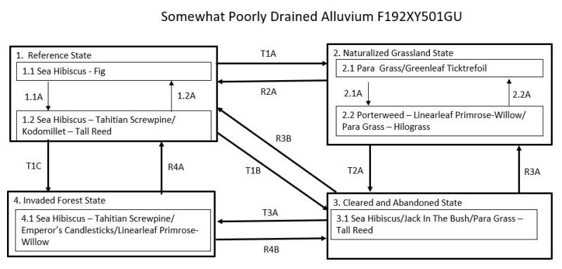
Click on box and path labels to scroll to the respective text.
Ecosystem states
| T1A | - | The Reference State (1) transitions to the Naturalized Grassland State (2) by removal of native vegetation and planting, or allowing colonization by, introduced grass species. |
|---|---|---|
| T1B | - | The Reference State (1) transitions to the Cleared and Abandoned State (3) when the overstory plants of the forest are removed and then the site is abandoned. This allows increased light available to shade-intolerant heliophytes (both native and introduced), to temporarily cover the ground. |
| T1C | - | The Reference State (1) transitions to the Invaded Forest State (4) by wind damage to the forest when there is a nearby source of seeds of invasive species or, more gradually, by damage to the forest understory by ungulates when there is a source of seeds of invasive species. |
| R2A | - | The Naturalized Grassland State (2) could theoretically be restored to the Reference State (1) by suppression of grassland vegetation and replanting with native species. Natural reseeding by native forest species can be expected if there is a nearby stand of suitable species. |
| T2A | - | The Naturalized Grassland State (2) transitions to the Cleared and Abandoned State (3) upon abandonment of grasslands, which are invaded by low-statured, native or introduced heliophytes. |
| R3B | - | The Cleared and Abandoned State (3) may be restored to the Reference State (1). The intensity of active restoration measures will be determined by the presence or lack of nearby native forest or, at least, some native trees as well as the density and species mix of grasses, vines, shrubs, and invasive trees present on the site, especially if many competitive introduced species are present. |
| R3A | - | The Cleared and Abandoned State (3) may be restored to the Naturalized Grassland State (2) by land clearing, weed control, and replanting grasses. |
| T3A | - | The Cleared and Abandoned State (3) transitions to the Invaded Forest State (4) by growth of an overstory of trees with an understory of shade-tolerant shrubs, vines, ferns, forbs, and grasses. The species mix is variable but may be mostly introduced species or a combination of native and introduced species. |
| R4A | - | The Invaded Forest State (4) can be restored to the Reference State (1). The difficulty, cost, and likelihood of success will depend on the species composition and amount and competitiveness of introduced species present on a given site. |
| R4B | - | The Invaded Forest State (4) can be restored to the Cleared and Abandoned State (3). After this “restoration,” State 3 is likely to rapidly transition back to State 4 due to presence of an abundant tree seed bank in the soil, unless fire is frequent. |
State 1 submodel, plant communities
| 1.1A | - | Storms that damage or kill trees by high wind speeds or flooding causes a phase change from 1.1 to 1.2 typified by a partial, temporary change in dominant tree species and a temporary increase in ground level vegetation. |
|---|---|---|
| 1.2A | - | Community phase 1.2 will revert to phase 1.1 with gradual regrowth of native species when given adequate time to recover after storm disturbance. |
State 2 submodel, plant communities
| 2.1A | - | Community phase 2.1 will change to 2.2 by invasion of the site by introduced shrubs and forbs. This process is facilitated by excessive grazing, which reduces the competitive advantage of para grass. |
|---|---|---|
| 2.2A | - | Community phase 2.2 can shift back to phase 2.1 by reducing grazing pressure on para grass (Urochloa mutica) and, when necessary, performing spot weed control on shrubs, forbs, and vines. |