Natural Resources
Conservation Service
Ecological site F131AY601MS
Batture - Mississippi River Unprotected By Levee Sites
Last updated: 6/10/2025
Accessed: 10/19/2025
General information
Provisional. A provisional ecological site description has undergone quality control and quality assurance review. It contains a working state and transition model and enough information to identify the ecological site.
MLRA notes
Major Land Resource Area (MLRA): 131A–Southern Mississippi River Alluvium
The Southern Mississippi River Alluvium (MLRA 131A) is the largest of 4 MLRAs within Land Resource Region O, the Mississippi Delta Cotton and Feed Grains Region. It occurs in portions of 7 states including Louisiana (32 percent), Arkansas (26 percent), Mississippi (26 percent), Missouri (12 percent), Tennessee (3 percent), Kentucky (1 percent), and Illinois (less than 1 percent). The MLRA is comprised of 29,555 square miles and extends roughly 650 miles from an area near Cape Girardeau, Missouri in the north to the MLRA’s transition to the Gulf Coast Marsh (MLRA 151) in the south. Average elevations range from 330 feet in the north to sea level in the southern part of the area. For much of the north-south distance, the MLRA is bounded to the east by an abrupt rise in elevation of loess-capped bluffs and hills, the Southern Mississippi Valley Loess (MLRA 134). West of the Mississippi River, the boundary is less distinct except to the northwest where the MLRA abuts the Ozark Plateaus and Ouachita province (MLRAs 116A, 117, and 118A). South of the Ozark and Ouachita escarpment, the MLRA adjoins the Southern Mississippi River Terraces (MLRA 131D), which includes the fabled Grand Prairie and merges with the valleys of the Arkansas and Ouachita rivers (MLRA 131B) and the Red River (MLRA 131C). Occurring within or bordering the Southern Mississippi River Alluvium are three separate loess-capped, upland remnants: Crowley’s Ridge, Macon Ridge, and Lafayette Loess Plain, which are western units of MLRA 134 (USDA-NRCS, 2006).
MLRA 131A is characterized by landscapes that were created and influenced by the current and earlier paths of the Mississippi River and its tributaries. Waters transporting the materials that formed the area originate from as far west as the east slope of the Continental Divide to the western edge of the Appalachian Divide in the east. This comprises a drainage basin of roughly 1,245,000 square miles and includes all or parts of thirty-one U.S. states and two Canadian provinces (Elliott, 1932). The drainage basin of the Mississippi River roughly resembles a funnel which has its spout at the Gulf of America. Waters from as far east as New York and as far west as Montana contribute to flows in the lower extent of the river (USACE, 2017). The soils of these alluvial landscapes are very deep, dominantly poorly and somewhat poorly drained, and have textures that are mostly loamy or clayey. Principal soil orders are Alfisols, Vertisols, Inceptisols, and Entisols (USDA-NRCS, 2006).
The fluvial processes that shaped the area were highly dynamic, diverse, and complex. During the Pleistocene epoch, multiple continental glacial-interglacial cycles resulted in extreme fluctuations in river discharge and sediment loads. A braided river regime characterized the fluvial dynamics of the Mississippi River through much of the last glacial cycle (Autin et al., 1991; Rittenhour et al., 2007). Rapid aggradation of glacial outwash led to the development of prominent valley train features over a large portion of the area (Autin et al., 1991; Saucier, 1994; Aslan and Autin, 1999; Blum et al., 2000; Rittenour et al., 2007). A changing climate, meltwater withdrawal, and sea-level change induced a transition from a braided river regime to a predominantly single-channeled, laterally migrating river system during the Holocene epoch (Rittenhour et al., 2007; Shen et al., 2012) – characteristics that continue today. Fluvial dynamics of the migrating river resulted in the development of broad meander belts, backswamp environments, and extensive deltaic complexes (Saucier, 1994; Klimas et al., 2011).
Tremendous expanses of bottomland hardwood forests once covered much of the area. Today, the land base is largely in agriculture production, and soybeans, cotton, corn, and rice are the principal crops with sugarcane rising in importance in the southernmost portion of the MLRA (USDA-NRCS, 2022).
Due to its size and biophysical variability, the technical team advised subdividing the MLRA into six subregions: Western Lowlands, St. Francis Basin, Yazoo Basin, Tensas Basin, Delta Plain, and Batture.
LRU notes
For the purpose of ecological site concepts, the MLRA was separated by the technical team into 6 subregions based on various assemblages of data reviewed. The subregion where this site is delineated extends through the length of MLRA 131A, but it differs from other subregions because it is still hydrologically impacted by the regular flow of the Mississippi River and its tributaries. This subregion is locally known as “Batture” which is defined for the purposes of this Ecological Site as the alluvial land between the Mississippi River channel and the constructed levee system or other flood constricting natural features, such as natural levees or high bluffs. Individual levee systems have been present along the Mississippi River since the first Europeans settled the region in the early 18th century, but its design has changed many times since that first levee. The changes were brought about mainly by flooding, which in turn drove other factors such as costs and politics (Rogers, 2005).
The Mississippi River and Tributaries (MR and T) Project is a comprehensive flood control and navigation plan for the Lower Mississippi River and tributary streams. The MR&T was authorized under the Flood Control Act of 1928 and is the responsibility of the Mississippi River Commission (MRC). The project consists primarily of a system of levees, channel improvement works, and floodways. Currently, the river is entirely contained by either bluffs or levees from Cairo, IL to a point 90 river miles below New Orleans, except where major tributaries are confluent. This effort has been extremely successful in reducing or eliminating flooding over most of the historic floodplain and contributing to agricultural and urban development. Over one million acres of this remnant bottomland forest lies within the leveed floodplain of the Lower Mississippi River where most sites are still subject to annual flooding. Peak river flows typically occur in March, April, and May (Klimas, 1988).
The Ecological sites within the Batture region of MLRA 131A will be the most transient of all the sites of the MLRA. In the protected subregions, the landscape will maintain a progression of development, unless there are anthropogenic forces that alter it or there is a catastrophic river event that breaches the levee system. Landforms throughout the Batture have direct hydrologic connectivity to the Mississippi River and are subject to annual or near annual flooding, sedimentation, and potential modification. For instance, low elevation landforms that are frequently flooded and ponded are subject to and may receive sediment deposition of several feet, transforming the local area to conditions more similar to a natural levee or ridge ecological site. Conversely, a local natural levee or ridge landform could receive severe scouring impacts during a catastrophic flood event, resulting in a complete removal of the former elevated feature to one that becomes lower in elevation and subject to frequent flooding and ponding. In this dynamic environment, migration of the river channel to new pathways along with redistribution of sediments is a persistent possibility. There is a potential for a given ecological site at the local level to undergo rapid transformation and development to any of the sites that have been identified within the Batture.
When working within the Batture Subregion, onsite verification of the conditions of a given location is critical to planning. It has been witnessed by the Author of this site concept, flooding in a crop field due to current high flows of the Mississippi River. While at the same time seeing irrigation of the adjacent growing crops, due to dry conditions in the higher elevation areas of the field. It has also been noted by members of the technical team, where restoration plantings on ridge sites was converted to eroded swales, while adjacent shallow water areas were completely filled by sandy sediment creating ridges, from a single flooding event.
Classification relationships
Major Land Resource Area (MLRA) and Land Resource Unit (LRU) (USDA-NRCS, 2006) MLRA 131A Southern Mississippi River Alluvium
EPA Level IV Ecoregion - 73a Northern Holocene Meander Belts, 73k Southern Holocene Meander Belts
The Natural Communities of Louisiana - (Louisiana Natural Heritage Program - Louisiana Department of Wildlife and Fisheries) - Forested Wetland, Bottomland Hardwood Forest, Batture
Ecological site concept
This ecological site occurs within the undulating landscape between the active river and man-made levee or upland bluffs of adjacent MLRA's. Active flooding, overwash, scour and sedimentation by the Mississippi River will impact the site. These sites have been altered greatly by anthropogenic means; the hydrology, soils, and vegetation have been altered beyond what would have naturally occurred in the region. Due to these alterations by construction of flood protection levees, the ecological sites that would have occurred on these locations are no longer relevant. There will be similarities to the sites found on the protected side of the levees, however, the hydrology, sedimentation and erosion have overshadowed all other ecological processes.
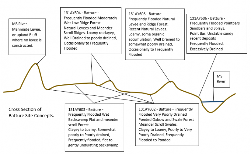
This Site Concept is utilized when a soil is not well defined or too broadly mapped to fit into one of the more refined site concepts for the Batture of MLRA 131A. The general concepts of this ecological site are intended to direct users to the following detailed descriptions after onsite determinations:
131AY602 - Batture - Frequently Flooded Very Poorly Drained Ponded Oxbow and Swale Forest
131AY603 - Batture - Frequently Flooded Wet Backswamp Flat Forest
131AY604 - Batture - Frequently Flooded Moderately Wet Low Ridge Forest
131AY605 - Batture - Frequently Flooded Natural Levee and Ridge Forest
131AY606 - Batture - Frequently Flooded Pointbars Sandbars and Splays
Of note, this site occurs within the “unprotected” or “batture lands” (i.e., the alluvial land between the river channel and the constructed levee system) side of the extensive Mississippi River levee system and is distinguished from similar landforms that are protected from current Mississippi flooding by constructed levees or natural features.
Associated sites
| F131AY602MS |
Batture - Frequently Flooded Very Poorly Drained Ponded Oxbow and Swale Forest |
|---|---|
| F131AY603MS |
Batture - Frequently Flooded Wet Backswamp Flat Forest |
| F131AY604MS |
Batture - Frequently Flooded Moderately Wet Low Ridge Forest |
| F131AY605MS |
Batture - Frequently Flooded Natural Levee and Ridge Forest |
| F131AY606MS |
Batture - Frequently Flooded Pointbars, Sandbars, and Splays |
Similar sites
| F131AY602MS |
Batture - Frequently Flooded Very Poorly Drained Ponded Oxbow and Swale Forest |
|---|---|
| F131AY603MS |
Batture - Frequently Flooded Wet Backswamp Flat Forest |
| F131AY604MS |
Batture - Frequently Flooded Moderately Wet Low Ridge Forest |
| F131AY605MS |
Batture - Frequently Flooded Natural Levee and Ridge Forest |
| F131AY606MS |
Batture - Frequently Flooded Pointbars, Sandbars, and Splays |
Table 1. Dominant plant species
| Tree |
(1) Salix nigra |
|---|---|
| Shrub |
Not specified |
| Herbaceous |
Not specified |
Click on box and path labels to scroll to the respective text.
Ecosystem states
| T 1-2 | - | Wind or water Force causing canopy gaps. |
|---|---|---|
| T 2-1 | - | Regeneration of natural species. |