
Natural Resources
Conservation Service
Ecological site F131AY504LA
Delta Plain - Natural Levees and Ridge Hardwoods
Last updated: 6/10/2025
Accessed: 10/19/2025
General information
Provisional. A provisional ecological site description has undergone quality control and quality assurance review. It contains a working state and transition model and enough information to identify the ecological site.
MLRA notes
Major Land Resource Area (MLRA): 131A–Southern Mississippi River Alluvium
The Southern Mississippi River Alluvium (MLRA 131A) is the largest of 4 MLRAs within Land Resource Region O, the Mississippi Delta Cotton and Feed Grains Region. It occurs in portions of 7 states including Louisiana (32 percent), Arkansas (26 percent), Mississippi (26 percent), Missouri (12 percent), Tennessee (3 percent), Kentucky (1 percent), and Illinois (less than 1 percent). The MLRA is comprised of 29,555 square miles and extends roughly 650 miles from an area near Cape Girardeau, Missouri in the north to the MLRA’s transition to the Gulf Coast Marsh (MLRA 151) in the south. Average elevations range from 330 feet in the north to sea level in the southern part of the area. For much of the north-south distance, the MLRA is bounded to the east by an abrupt rise in elevation of loess-capped bluffs and hills, the Southern Mississippi Valley Loess (MLRA 134). West of the Mississippi River, the boundary is less distinct except to the northwest where the MLRA abuts the Ozark Plateaus and Ouachita province (MLRAs 116A, 117, and 118A). South of the Ozark and Ouachita escarpment, the MLRA adjoins the Southern Mississippi River Terraces (MLRA 131D), which includes the fabled Grand Prairie and merges with the valleys of the Arkansas and Ouachita rivers (MLRA 131B) and the Red River (MLRA 131C). Occurring within or bordering the Southern Mississippi River Alluvium are three separate loess-capped, upland remnants: Crowley’s Ridge, Macon Ridge, and Lafayette Loess Plain, which are western units of MLRA 134 (USDA-NRCS, 2006a).
MLRA 131A is characterized by landscapes that were created and influenced by the current and earlier paths of the Mississippi River and its tributaries. Waters transporting the materials that formed the area originate from as far west as the east slope of the Continental Divide to the western edge of the Appalachian Divide in the east. This comprises a drainage basin of roughly 1,245,000 square miles and includes all or parts of thirty-one U.S. states and two Canadian provinces (Elliott, 1932). The drainage basin of the Mississippi River roughly resembles a funnel which has its spout at the Gulf of America. Waters from as far east as New York and as far west as Montana contribute to flows in the lower extent of the river (USACE, 2017). The soils of these alluvial landscapes are very deep, dominantly poorly and somewhat poorly drained, and have textures that are mostly loamy or clayey. Principal soil orders are Alfisols, Vertisols, Inceptisols, and Entisols (USDA-NRCS, 2006a).
The fluvial processes that shaped the area were highly dynamic, diverse, and complex. During the Pleistocene epoch, multiple continental glacial-interglacial cycles resulted in extreme fluctuations in river discharge and sediment loads. A braided river regime characterized the fluvial dynamics of the Mississippi River through much of the last glacial cycle (Autin et al., 1991; Rittenhour et al., 2007). Rapid aggradation of glacial outwash led to the development of prominent valley train features over a large portion of the area (Autin et al., 1991; Saucier, 1994; Aslan and Autin, 1999; Blum et al., 2000; Rittenour et al., 2007). A changing climate, meltwater withdrawal, and sea-level change induced a transition from a braided river regime to a predominantly single-channeled, laterally migrating river system during the Holocene epoch (Rittenhour et al., 2007; Shen et al., 2012) – characteristics that continue today. Fluvial dynamics of the migrating river resulted in the development of broad meander belts, backswamp environments, and extensive deltaic complexes (Saucier, 1994; Klimas et al., 2011).
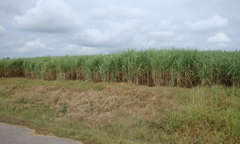
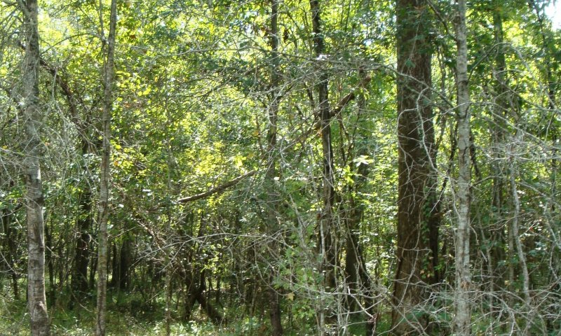
Tremendous expanses of bottomland hardwood forests once covered much of the area. Today, the land base is largely in agriculture production, and soybeans, cotton, corn, and rice are the principal crops with sugarcane rising in importance in the southernmost portion of the MLRA (USDA-NRCS, 2022).
Due to its size and biophysical variability, the technical team advised subdividing the MLRA into six subregions: Western Lowlands, St. Francis Basin, Yazoo Basin, Tensas Basin, Delta Plain, and Batture.
LRU notes
The Deltaic Plain of MLRA 131A is located in Louisiana, south of the Old River Control Structure on the Mississippi River. This portion of the MLRA is greatly affected by changes in hydrology over time, by both natural and anthropogenic forces. The landscape was built by the flooding of the Mississippi River with influences of the entire drainage basin.
The Mississippi River built the Deltaic Plain landscape through its multiple meandering channel belts and sediment deposition. The geologic development of coastal Louisiana is closely related to shifting Mississippi River courses. The Mississippi River Deltaic Plain developed as the Mississippi River changed its course multiple times throughout the Holocene Age. The Deltaic Plain is composed of six major delta complexes, two of which are prograding and four are degrading. Recognition that the Deltaic Plain is formed by an orderly progression of events related to shifting Mississippi River courses led to the identification and characterization of the deltaic cycle. The delta cycle is a dynamic and episodic process alternating between periods of seaward progradation of deltas (regressive deposition) and the subsequent landward retreat of deltaic headlands as deltas are abandoned, reworked, and submerged by marine waters (transgressive deposition) (USACE 2004). Within these shifts in land building and subsiding, the complexity of the ecological sites are realized. The interacting relationship between the alluvial landscape of MLRA 131A and the marsh landscape of MLRA 151 provides a gradual transition that obscures the boundary of these two regions. For the purposes of describing ecological sites, MLRA 131A sites are confined to those that are regarded as historically containing forested conditions and MLRA 151 sites confined to areas historically dominated by herbaceous marsh species. In addition to the interaction with MLRA 151 marshes, transitions from the Deltaic Plain into the adjacent MLRA 134 Southern Mississippi Valley Loess are abrupt in most places and are marked by loess covered plains to the east and west of the Deltaic Plain.
Classification relationships
Major Land Resource Area (MLRA) and Land Resource Unit (LRU) (USDA-NRCS, 2006) MLRA 131A Southern Mississippi River Alluvium
The Natural Communities of Louisiana - (Louisiana Natural Heritage Program - Louisiana Department of Wildlife and Fisheries)
EPA Level IV Ecoregion (73n - Inland Swamps, Portions of 73k - Southern Holocene Meander Belts & 73m Southern Backswamps)
Ecological site concept
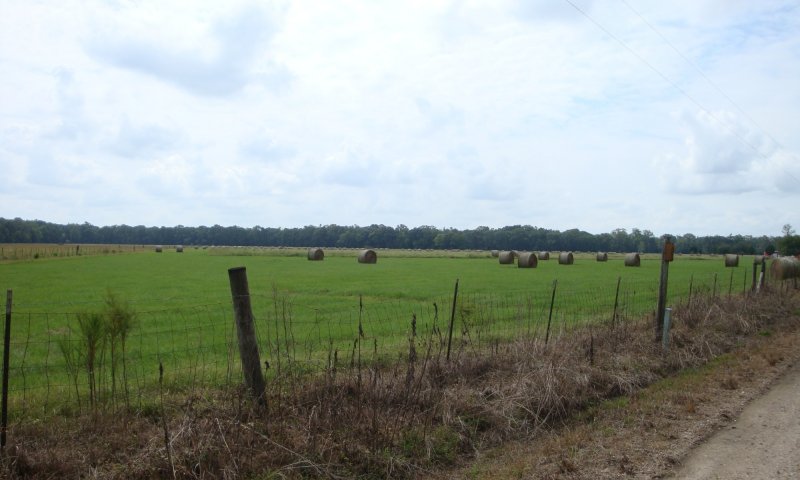
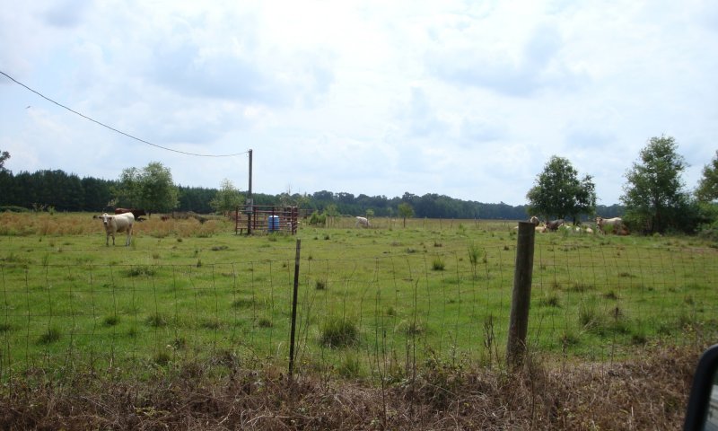
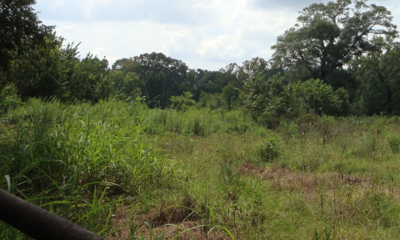
This site is alluvial plain forests that are rarely to occasionally flooded generally outside of the growing season. These very deep, well to moderately well drained, moderately permeable soils formed in silty and loamy alluvium and occur on natural levees, loamy splays, crevasse ridges, or meander scroll ridges in the Mississippi River Deltaic Plain. This site concept is the highest elevation on the local landscape and prior to levee construction it would flood at times providing additional coarse-textured sediment.
This site is on flood plains in Level IV EPA Ecoregion 73n Inland Swamps, 73K Southern Holocene Meander Belts, and portions of 73m Southern Backswamps, of the Southern Mississippi River Alluvium Major Land Resource Area. Within the southernmost reach of the MLRA is the Deltaic Plain which extends from approximately where the Red River influence begins within the MLRA and to the south.
Of note, this site occurs on the protected side of the extensive Mississippi River levee system and is distinguished from similar landforms within the batture lands (i.e., the alluvial land between the river channel and the constructed levee system). Some locations of this site will receive Mississippi River flood waters at times within the Atchafalaya Floodway system and is similar to the flooding that would have occurred historically however the frequency and magnitude will be altered due to control structures and management.
Associated sites
| F131AY503LA |
Delta Plain - Somewhat Poorly Drained Bottomland Hardwoods The Somewhat poorly drained bottomland hardwood site will fit on the landscape at the next lower elevation of the local landscape and there will be a transition between these sites that is gradual in some locations. |
|---|
Similar sites
| F131AY406LA |
Tensas Basin - Natural Levees and Ridge Hardwoods The Tensas Basin - Natural Levee and Ridge site will occupy the same position on the landscape however it will be found further north in the MLRA above where the Red River enters the MLRA. |
|---|
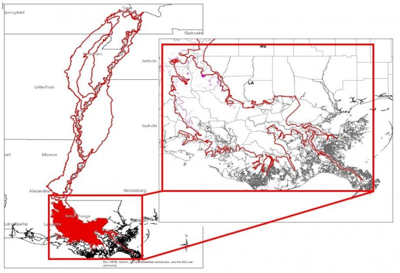
Figure 1. 131AY504 ES Extent Map
Table 1. Dominant plant species
| Tree |
Not specified |
|---|---|
| Shrub |
Not specified |
| Herbaceous |
Not specified |

Click on box and path labels to scroll to the respective text.
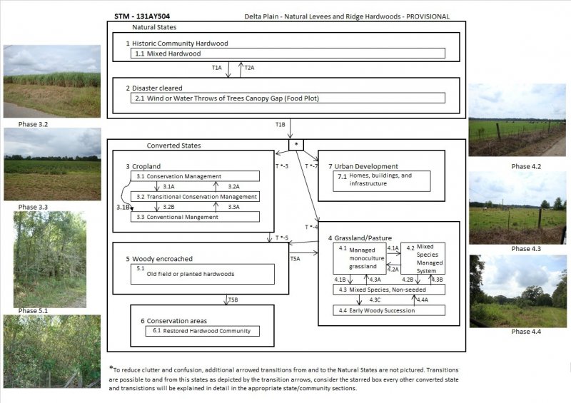
Ecosystem states
States 2, 5 and 7 (additional transitions)
States 3, 7 and 4 (additional transitions)
| T1A | - | Wind or water Force causing canopy gaps. |
|---|---|---|
| T2A | - | Regeneration of Hardwood species. |
| T1B | - | Clear and established the desired Community |
| T1B | - | Clear and established the desired Community |
| T1B | - | Clear and established the desired Community |
| T1B | - | Clear and established the desired Community |
| T*4 | - | Establish desired forage species and manage for grazing. |
| T*7 | - | Construct and maintain urban infrastructure. |
| T*3 | - | Establish and manage crop rotation. |
| T*5 | - | Plant or natural regeneration of woody species. |
| T*7 | - | Construct and maintain urban infrastructure. |
| T5A | - | Heavy Brush mgmt. |
| T5B | - | Manage succession for historic community. |
| T*7 | - | Construct and maintain urban infrastructure. |
State 1 submodel, plant communities
State 2 submodel, plant communities
State 3 submodel, plant communities
| 3.1A | - | Soil disturbance (Tillage) which reduces Soil Health. |
|---|---|---|
| 3.1B | - | Conventional tillage, seeding, and fertility Management for crops. |
| 3.2A | - | No-till, Cover crops, Reduced Till - Soil Health Improvements |
| 3.2B | - | Conventional tillage, seeding, and fertility Management for crops. |
| 3.3A | - | No-till, Cover crops, Reduced Till with Soil Health Improvements as a goal. |
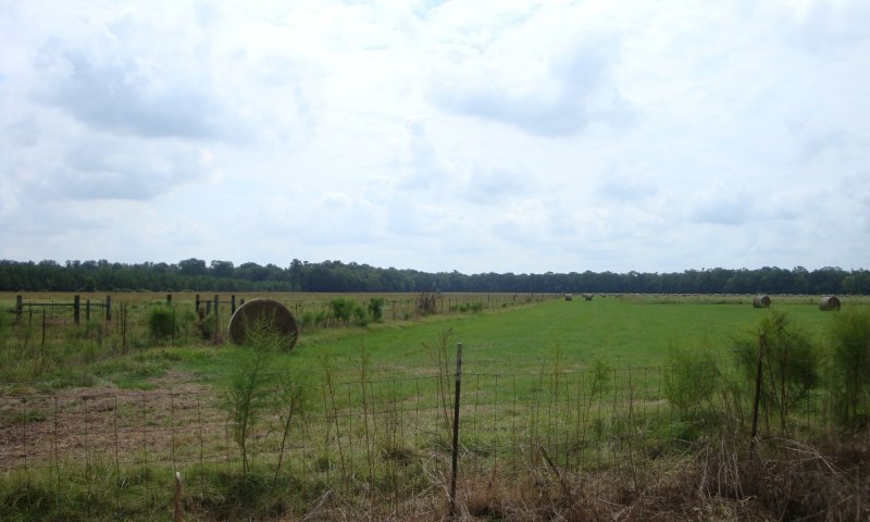
State 4 submodel, plant communities
| 4.1A | - | Seeding and/or Management for desired species composition. |
|---|---|---|
| 4.1B | - | Species Management without overseeding. |
| 4.2A | - | Seeding and/or Management for desired species composition. |
| 4.2B | - | Seeding and/or Management for desired species composition. |
| 4.3A | - | Seeding, fertilizing, management/ removal of unwanted species. |
| 4.3B | - | Seeding and/or Management for desired species composition. |
| 4.3C | - | Lack of disturbance: No or minimal Mowing, burning, herbivory or Brush Mgmt. and/or Plant or natural regeneration of woody species. |
| 4.4A | - | Brush management / removal of unwanted plants. |