Natural Resources
Conservation Service
Ecological site F131AY201AR
St. Francis - Wet Clayey Backswamp Flat
Last updated: 6/10/2025
Accessed: 10/19/2025
General information
Provisional. A provisional ecological site description has undergone quality control and quality assurance review. It contains a working state and transition model and enough information to identify the ecological site.
MLRA notes
Major Land Resource Area (MLRA): 131A–Southern Mississippi River Alluvium
The Southern Mississippi River Alluvium (MLRA 131A) is the largest of 4 MLRAs within Land Resource Region O, the Mississippi Delta Cotton and Feed Grains Region. It occurs in portions of 7 states including Louisiana (32 percent), Arkansas (26 percent), Mississippi (26 percent), Missouri (12 percent), Tennessee (3 percent), Kentucky (1 percent), and Illinois (less than 1 percent). The MLRA is comprised of 29,555 square miles and extends roughly 650 miles from an area near Cape Girardeau, Missouri in the north to the MLRA’s transition to the Gulf Coast Marsh (MLRA 151) in the south. Average elevations range from 330 feet in the north to sea level in the southern part of the area. For much of the north-south distance, the MLRA is bounded to the east by an abrupt rise in elevation of loess-capped bluffs and hills, the Southern Mississippi Valley Loess (MLRA 134). West of the Mississippi River, the boundary is less distinct except to the northwest where the MLRA abuts the Ozark Plateaus and Ouachita province (MLRAs 116A, 117, and 118A). South of the Ozark and Ouachita escarpment, the MLRA adjoins the Southern Mississippi River Terraces (MLRA 131D), which includes the fabled Grand Prairie and merges with the valleys of the Arkansas and Ouachita rivers (MLRA 131B) and the Red River (MLRA 131C). Occurring within or bordering the Southern Mississippi River Alluvium are three separate loess-capped, upland remnants: Crowley’s Ridge, Macon Ridge, and Lafayette Loess Plain, which are western units of MLRA 134 (USDA-NRCS, 2006a).
MLRA 131A is characterized by landscapes that were created and influenced by the current and earlier paths of the Mississippi River and its tributaries. Waters transporting the materials that formed the area originate from as far west as the east slope of the Continental Divide to the western edge of the Appalachian Divide in the east. This comprises a drainage basin of roughly 1,245,000 square miles and includes all or parts of thirty-one U.S. states and two Canadian provinces (Elliott, 1932). The drainage basin of the Mississippi River roughly resembles a funnel, which has its spout at the Gulf of America. Waters from as far east as New York and as far west as Montana contribute to flows in the lower extent of the river (USACE, 2017). The soils of these alluvial landscapes are very deep, dominantly poorly and somewhat poorly drained, and have textures that are mostly loamy or clayey. Principal soil orders are Alfisols, Vertisols, Inceptisols, and Entisols (USDA-NRCS, 2006a).
The fluvial processes that shaped the area were highly dynamic, diverse, and complex. During the Pleistocene epoch, multiple continental glacial-interglacial cycles resulted in extreme fluctuations in river discharge and sediment loads. A braided river regime characterized the fluvial dynamics of the Mississippi River through much of the last glacial cycle (Autin et al., 1991; Rittenhour et al., 2007). Rapid aggradation of glacial outwash led to the development of prominent valley train features over a large portion of the area (Autin et al., 1991; Saucier, 1994; Aslan and Autin, 1999; Blum et al., 2000; Rittenour et al., 2007). A changing climate, meltwater withdrawal, and sea-level change induced a transition from a braided river regime to a predominantly single-channeled, laterally migrating river system during the Holocene epoch (Rittenhour et al., 2007; Shen et al., 2012) – characteristics that continue today. Fluvial dynamics of the migrating river resulted in the development of broad meander belts, backswamp environments, and extensive deltaic complexes (Saucier, 1994; Klimas et al., 2011a).
Tremendous expanses of bottomland hardwood forests once covered much of the area. Today, the land base is largely in agriculture production, and soybeans, cotton, corn, and rice are the principal crops with sugarcane rising in importance in the southernmost portion of the MLRA (USDA-NRCS, 2022).
Due to its size and biophysical variability, the technical team advised subdividing the MLRA into six subregions: Western Lowlands, St. Francis Basin, Yazoo Basin, Tensas Basin, Delta Plain, and Batture.
LRU notes
There are no agency-approved and established Land Resource Units (LRUs) for MLRA 131A. However, the characteristics of each of the six subregions in this MLRA warrant noting and are presented here for each associated ecological site. This provisional ecological site is broadly mapped within the Western Lowlands and the St. Francis Basin.
The Western Lowlands subregion or basin is a broad, nearly level alluvial plain located in southeastern Missouri and northeastern Arkansas. It and the St. Francis Basin form the northwestern terminus of MLRA 131A. North to south, the Lowlands extends about 225 miles from Cape Girardeau, Missouri to near Helena, Arkansas, encompassing roughly 6,800 square miles and making it the second largest subregion or basin (behind the Yazoo Basin) in MLRA 131A (Saucier, 1994). For much of its distribution, the Western Lowlands border Crowley’s Ridge to the east, the Ozark Escarpment to the northwest and west, and the Grand Prairie region to the southwest (Smith and Saucier, 1971). Towards the south, the Western Lowlands largely encapsulates the White River floodplain and associated tributaries and ends at its juncture with the Batture subregion (i.e., along the constructed Mississippi River levees). Elevation ranges from about 360 feet in the north to around 150 feet in the south.
The Western Lowlands is noted for supporting the ancestral path of the Mississippi River. Historically, the river entered the Lower Mississippi Valley just south of present-day Cape Girardeau through the Advance Lowlands, a narrow (north to south) alluvial plain between the Ozark Escarpment to the north and the Benton (or Commerce) Hills and Crowley’s Ridge to the south (Rittenour et al., 2007). The pathway of the river largely remained between Crowley’s Ridge to the east and the Ozark Escarpment to the west for significant periods during the Pleistocene epoch (ca. 11,700 to 2,580,000 years B.P.; chronology after Head, 2019) before shifting to its current position. Enormous quantities of glacial meltwater and outwash materials were funneled through the area during multiple continental glacial cycles (Saucier, 1994). A large proportion of the major geomorphic features comprising the Western Lowlands, today, are manifestations of the last continental glacial period, the Wisconsin Glaciation (ca. 11,000 to 75,000 years B.P.; chronology interpreted from Saucier, 1994). Fluvial dynamics of the outwash episodes resulted in braided river regimes and the development of broad, complex aggraded landscapes often referred to as valley trains (see Saucier, 1994) or braided channel belts (see Rittenour et al., 2007). The most prominent features consist of a series of successive, level to nearly-level valley trains that decrease in elevation (east to west) in an abrupt, step-like (scarp) fashion. These broad valley trains at varying elevations are interpreted to represent different glacial outwash episodes with the highest elevations developing during earlier periods and the lowest consisting of more recent deposits. On the lower valley trains, remnant braided outwash channels are sometimes visible and may support active stream systems, today (Klimas et al., 2012). An additional feature that is broadly scattered on some valley trains is the “sand dune field.” Dune fields vary in size from 5 to 25 square miles in extent and may be comprised of tens to hundreds of discrete dunes. These eolian structures are generally positioned within or immediately east of large, relict braided channels and are interpreted to have been formed on midchannel braid bars or islands (Saucier, 1994).
The Mississippi River shifted away from the Western Lowlands and into the St. Francis Basin during the Late Wisconsin Stage (ca. 11,000 to 30,000 years B.P.; chronology interpreted from Saucier, 1994). Rittenour et al. (2007) places a timeframe of river abandonment around 19,000 to 21,000 years B.P. based on optically stimulated luminescence sampling of a large crevasse splay in the Advance Lowlands. This sand splay is interpreted to have been deposited by the ancestral Mississippi River representing the last episode of flooding by the river into the Western Lowlands (Blum et al., 2000; Rittenour et al., 2007).
Today, stream and river systems flowing through the Western Lowlands have formed narrow valleys and floodplains on which younger Holocene-age (ca. 11,700 years B.P. to present; chronology after Head, 2019) materials are deposited. Drainage of the basin largely originates or enters the Lowlands from the Ozark Plateau by way of the St. Francis, Black, Current, Spring, White, and Little Red rivers. Their combined flow forms the White River, which discharges into the Arkansas River. Two important tributaries to the White, the Cache River and Bayou De View, are among the few stream systems that originate within the Western Lowlands. Landforms of these systems are typical of meandering low-gradient streams and include natural levees, point bars, poorly drained backswamps, abandoned channels (oxbow lakes), and local depressions. Historically, these low landscapes were subject to frequent flooding. Ponding of long durations occurred locally on the higher, nearly level valley train terraces following periods of heavy rain. To lessen the severity of flooding and ponding, extensive modification of the basin’s natural hydrology was implemented including extensive levee construction, channel modifications, upstream reservoir construction, land leveled areas, and an extensive network of local surface drainage systems. Even with these measures, the lower reaches of the White River floodplain remain subject to backwater inundation during major flood events on the Mississippi River (Klimas et al., 2012).
Throughout their combined north-south distribution, the Western Lowlands and St. Francis Basin are mostly separated by Crowley’s Ridge. There is one small area in the northern extent of the MLRA where the two basins overlap or join, the Advance Lowlands. In administering the Ecological Site Inventory, the decision was made to join the Western Lowlands and St. Francis Basin along the interface of two Wisconsin-age braided channel belts (valley trains) of different ages as defined by Saucier (1994) and corroborated by Rittenour et al. (2007). The younger of the two belts, the Morehouse Lowland (designated as Late Wisconsin Stage valley train Level 1, Pvl1), extends north to south through a major portion of the St. Francis Basin from southeast Missouri into northeast Arkansas. The older belt (designated as Early Wisconsin Stage valley train Level 2, Pve2) is a prominent valley train terrace throughout most of the Western Lowlands’ north-south length (braid belt designation and distribution after Saucier, 1994).
The St. Francis Basin is geographically positioned in northeastern Arkansas and southeastern Missouri where it, in addition to the Batture and Western Lowlands, form the northern terminus of MLRA 131A. For convenience and ease of administering the Ecological Site Inventory, small portions of the MLRA occurring east of the Mississippi River in extreme western Tennessee and Kentucky are collectively grouped with the basin’s extent in Arkansas and Missouri. The following characterization includes the combined area.
The MLRA boundary of the basin extends some 190 miles (north to south) from Cape Girardeau, Missouri to the vicinity of Helena, Arkansas. For much of its north-south distance, its width (east to west) is approximately 40 miles but narrows considerably south of Memphis, TN. The basin is bounded to the west by Crowley’s Ridge and to the east by the most recent meander belt of the Mississippi River. Elevations range from about 340 feet in the north to around 175 feet in the south (Saucier, 1994). St. Francis Basin includes portions of: Lee, St. Francis, Crittendon, Cross, Poinsett, and Mississippi counties of Arkansas; Pemiscot, Dunkin, New Madrid, and Mississippi counties of Missouri; Lake, Dyer, and Lauderdale counties of Tennessee. Major towns include: West Memphis, Marked Tree, Trumann, Blytheville, Paragould, Piggott, and Black Oak, Arkansas; Caruthersville, Hayti, Portageville, Kennett, Charleston, Sikeston, and Cape Girardeau, Missouri; and Tiptonville, Tennessee. Major highways include: Interstate 55, Interstate 40, U.S. Highway 61, U.S. Highway 63, U.S. Highway 64, U.S. Highway 78, and TN Highway 103.
The geomorphology of the basin is exceedingly complex – manifestations of incredible hydrogeologic and geologic forces. The most significant of these forces for the Mississippi River Valley was serving as a sluiceway through which huge quantities of glacial meltwater and outwash were funneled during multiple continental glaciations. The northwestern two thirds of the basin is mainly comprised of Late Pleistocene (ca. 11,700 to 129,000 years B.P.; chronology after Head, 2019) glacial outwash materials. Large landscapes or “basin subareas” were created or influenced by tremendous amounts of outwash material that, episodically, were released during catastrophic outburst floods of enormous magnitude (Saucier, 1994). Fluvial dynamics of these events resulted in braided river regimes of both the Mississippi and Ohio rivers. Examples of large landscapes that were shaped and reshaped by these fluvial processes and episodes include Sikeston Ridge, Charleston Fan, Morehouse Lowland, and Malden Plain (Stevens and Krusekopf, 2020). Major geomorphic features created in the wake of these forces include prominent sandy ridges; broad, braided-stream terraces (valley trains) at varying elevations or levels; and eolian environments of sand dune fields east of Sikeston Ridge.
A changing climate, meltwater withdrawal, and sea-level change induced a transition from a braided river regime to a predominantly single-channeled, laterally migrating river system during the Holocene epoch (ca. 11,700 years B.P. to present; chronology after Head, 2019) (Rittenour et al., 2007; Shen et al., 2012). Landscapes across the southeastern third of the St. Francis Basin are mainly comprised of former paths of the Mississippi River and its associated alluvial environment of sinuous meander belts. Major landforms comprising the meander belt environment include natural levees, point bar deposits (meander scrolls) and abandoned channels (oxbow lakes) and courses. The higher elevations of natural levees and point bars form an alluvial ridge, which often directs local drainage and floodwaters to the intervening flood basins or backswamps (Saucier, 1994).
In addition to hydrologic influences, the basin’s landscapes are subject to geologic forces. In 1811-1812, four of the largest earthquakes to hit eastern North America occurred in an area that encompassed extreme northeastern Arkansas, southeastern Missouri, and northwestern Tennessee. This area is known as the New Madrid Seismic Zone, which is named after a small settlement near the epicenter of one of the earthquakes (Saucier, 1994). Reports of the New Madrid earthquakes included widespread bank caving, reversal of river flow, landslides, earth waves, forest destruction, land uplifts, and land sinking. A few of the notable land areas or features attributed to or influenced by the seismic events include the St. Francis Sunken Lands, Tiptonville Dome, Ridgely Ridge, Reelfoot Lake, and massive landslides occurring along the adjoining Loess Bluffs of MLRA 134 (Fuller, 1912; Saucier, 1994). Perhaps the most dramatic geomorphic effects were the land fissuring and sand blows resulting from liquefaction (Saucier, 1994). According to Castilla and Audemard (2007), these are “…the largest ever-reported isolated sand blows.” Saucier (1994) emphasized that there are millions of liquefaction features from the earthquakes that are distributed over a 4,000 square mile area.
The movement of water through the basin is influenced by the complex sequence of remnant braided outwash channels, overflow channels, distributaries, and former channels and courses of the Mississippi River. Many of these features convey smaller modern streams within them. Principal streams of the basin are its namesake, the St. Francis River in addition to Little Rivers, Tyronza River, and Pemiscot Bayou (Saucier, 1994). Historically, large floods on the Mississippi River and in the St. Francis tributary system and greater basin led to frequent flooding, inundating landscapes of low relief for very long durations (Moore, 1972). To lessen the severity of flooding, the St. Francis Basin underwent a coordinated and comprehensive flood control and drainage effort. Extensive modification of the basin’s natural hydrology included hundreds of miles of constructed levees along the mainstem of the Mississippi River and basin tributaries; channel modifications on many streams; constructed floodways; water control structures; land leveled areas; and an extensive network of surface drainage systems (Klimas et al., 2013). The extensive modifications to the basin’s hydrology coupled with increased access set the stage for broadscale conversion of former forestland to a variety of land uses with agriculture production being dominant.
All ecological sites in the St. Francis Basin are bounded by the extensive constructed levee system along the Mississippi River. The constructed levee occurs on both sides (i.e., east and west) of the active river channel. The areas protected by levees east of the Mississippi River include portions of Lake, Obion, Dyer, and northern Lauderdale counties in Tennessee and the western extent of Fulton County, Kentucky. (Soils mapped in southern Illinois’s portion of MLRA 131A mostly have a mesic soil temperature regime and do not correlate to this ecological site.) All lands between the river channel and the constructed levee (or Loess Hills where levees are absent) are referred to as the Batture, and that subregion encapsulates its own complement of ecological sites due to significantly different hydrologic regimes (Smith and Klimas, 2002).
Classification relationships
All or portions of the geographic range of this site fall within several ecological/land classifications including:
- NRCS Major Land Resource Area (MLRA) 131A – Southern Mississippi River Alluvium (USDA-NRCS, 2006a)
- National Hierarchical Framework of Ecological Units: 234 Lower Mississippi Riverine Forest Province; 234D White and Black River Alluvial Plains Section; 234Da North Mississippi River Alluvial Plain Subsection (Cleland et al., 2007)
- Environmental Protection Agency Level III Ecoregion: 8.5.2 Mississippi Alluvial Plain; Level IV Ecoregion: Northern Holocene Meander Belt, 73a; Northern Pleistocene Valley Trains, 73b; St. Francis Lowlands, 73c; Northern Backswamp, 73d; Western Lowlands Holocene Meander Belts, 73f; Western Lowlands Pleistocene Valley Trains, 73g (Griffith et al., 1998; Chapman et al., 2002; Woods et al., 2002; Woods et al., 2004; Wiken et al., 2011)
- Mississippi River Low Floodplain (Bottomland), Ecological System CES203.195 (NatureServe, 2020)
- Overcup Oak – Water Hickory – (Nuttall Oak)/Eastern Swampprivet Floodplain Forest, CEGL002423 (NatureServe, 2020)
- The following are the HGM Subclasses, geomorphic setting, and PNV associations that appear to best correspond to this site in the 1) Western Lowlands (Klimas et al., 2012) and 2) St. Francis Basin (Klimas et al., 2013). 1) Western Lowlands: RB7, Frequently flooded lowlands, Overcup Oak – Bitter Pecan; 2) St. Francis Basin: RB7, Frequently flooded lowlands, Overcup Oak – Bitter Pecan; F6, Poorly drained lowlands, Nuttall Oak – Willow Oak
Ecological site concept
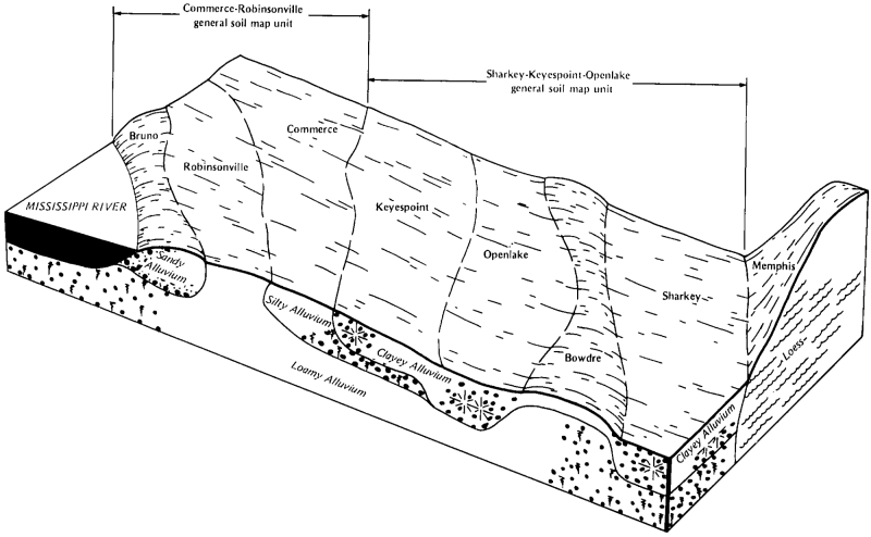
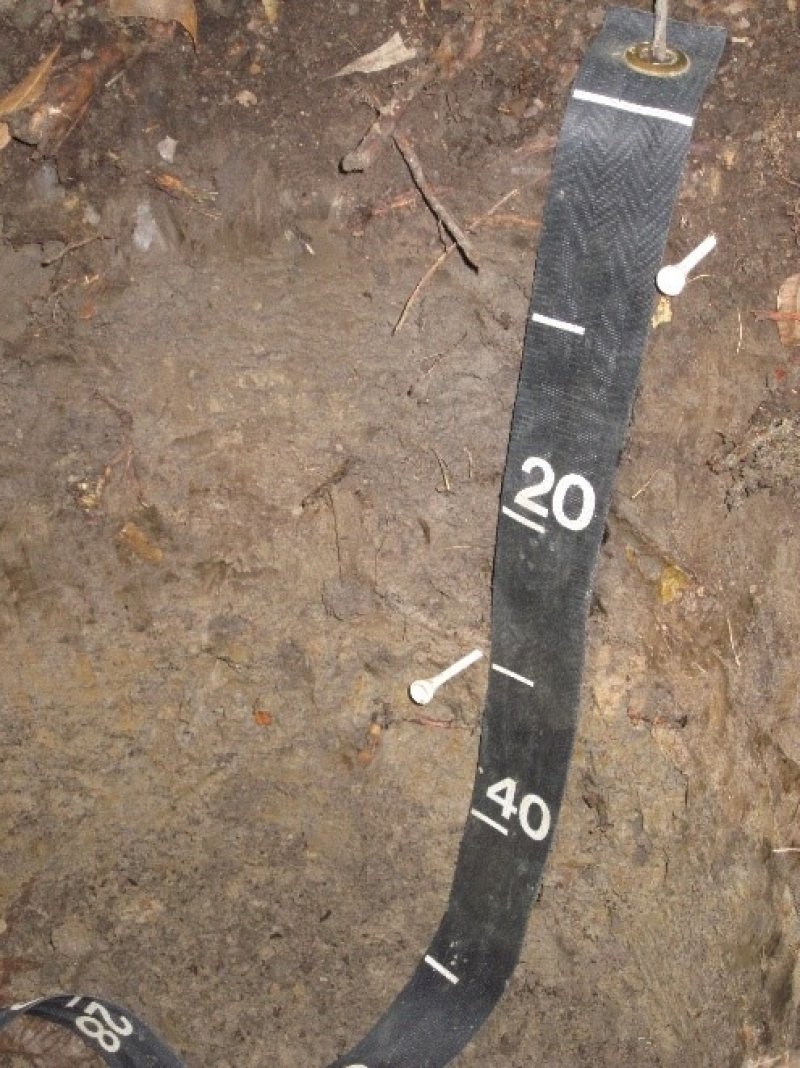
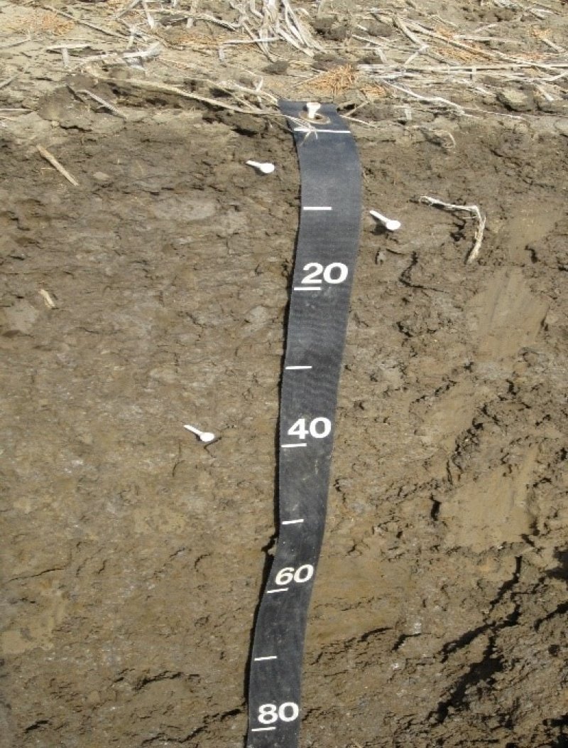
This ecological site is representative of the broad, low backswamp flats (talfs) that developed on the periphery of and are bounded by the higher features of former and recent river meander belts. Additionally, the soils of this site have also been mapped on swales of abandoned meander scrolls and across broad areas of Late Pleistocene valley trains. The soils coupled with their geomorphic setting are quite diagnostic and characteristic of the site. They are very deep, poorly drained and have very slow permeability. Accretion and buildup of these heavy clays occur in low, overbank environments where floodwaters become entrapped. Slopes of this site are dominantly 0 to 0.5 percent but may range up to 1 percent. These poorly drained soils have a hydric rating, and they support obligate and facultative wetland vegetation. Dominant natural vegetation of this site is often described as an overcup oak (Quercus lyrata) – water hickory (Carya aquatica) wetland forest association, particularly in areas that frequently flood and pond for long durations. Community associates include Nuttall oak (Q. texana), willow oak (Q. phellos), sweetgum (Liquidambar styraciflua), green ash (Fraxinus pennsylvanica), Drummond’s maple (Acer drummondii), cedar elm (Ulmus crassifolia), water locust (Gleditsia aquatica), common persimmon (Diospyros virginiana), eastern swampprivet (Forestiera acuminata), and planertree (Planera aquatica) with American elm (Ulmus americana) and sugarberry (Celtis laevigata) increasing in abundance in areas of more recent disturbance. In drier locations, overcup oak and water hickory may become minor components with dominance shifting to other community associates such as sweetgum, willow oak, Nuttall oak, green ash, American elm, and sugarberry in varying abundance and dominance patterns. This site primarily occurs in the St. Francis Basin but also in portions of the Western Lowlands.
The species listed in Table 1 were derived from literature reviews, conversations with technical specialists, and limited observations. One or more of the species listed may not be dominant or present at a given location, and opinions may differ as to the dominant or representative species of this ecological site. Extreme caution should be exercised when developing or inferring conservation decisions, actions, or determinations based on Table 1, alone. A more complete listing of species anticipated on this site, including species targeted for their conservation value, can be found in the Ecological Dynamics section of this report.
Associated sites
| F131AY105AR |
Western Lowlands - Frequently Flooded and Ponded Oxbow and Swale Forest This site occupies backswamp depressions and sloughs, which occur in close association with the level surfaces of the clayey backswamps, F131AY201AR. |
|---|---|
| F131AY202AR |
St. Francis - Low Clayey Backswamp Ridge Forest This site is perhaps most characteristic of slight or low ridges and rises on broad backswamps. In some locations, these slightly elevated and elongated rises occur in a repeated, undulating pattern with individual ridges being separated by the intervening clayey flats of F131AY201AR. |
| F131AY203AR |
St. Francis - Wet Transitional Backswamp Forest This site mainly functions as a transitional bridge between the toe and lower backslopes of recent natural levees to the low backswamp environments of F131AY201AR. Where the two sites adjoin, the heavy clay soils of the Sharkey series are typically the representative backswamp component of site F131AY201AR. |
| F131AY211AR |
St. Francis - Old Wet Natural Levee and Meander Scroll Forest This site is characteristic of the nearly level, poorly drained toe slopes of former Mississippi River natural levees and meander scroll environments. Locally, the site adjoins the wet, clayey backswamps of F131AY201AR. |
| F131AY214AR |
St. Francis - Recent Wet Natural Levee and Meander Scroll Forest This site is characteristic of the nearly level, poorly drained toe slopes of recent Mississippi River natural levees and meander scroll environments. Locally, the site adjoins the wet clayey soils of F131AY201AR, especially in some meander scroll environments. |
| F131AY208AR |
St. Francis - Sandy Natural Levee and Meander Scroll Forest The sandy soils of F131AY208AR occur in complex with the heavy clayey soils of F131AY201AR where sand blows extruded from layers beneath the overlying clay during the New Madrid earthquake of 1811-1812. |
Similar sites
| F131AY302MS |
Yazoo - Wet Clayey Backswamp Flat Forest This site occurs in backswamp environments and is generally comprised of similar soils as F131AY201AR. The single distinguishing feature is the location of F131AY302MS is within the Yazoo Basin. |
|---|---|
| F131AY402LA |
Tensas Basin - Poorly Drained Backswamp This site occurs in backswamp environments and is generally comprised of similar soils as F131AY201AR. The single distinguishing feature is the location of F131AY402LA is within the Tensas Basin. |
| F131AY502LA |
Delta Plain - Poorly Drained Backswamp This site occurs in backswamp environments and is generally comprised of similar soils as F131AY201AR. The single distinguishing feature is the location of F131AY502LA is within the Delta Plain. |
| F131AY603MS |
Batture - Frequently Flooded Wet Backswamp Flat Forest This site occurs on the same or similar geomorphic features as F131AY201AR. The principal difference is F131AY603MS occurs within the Batture, which is the area subjected to direct overflow from the active Mississippi River channel. |
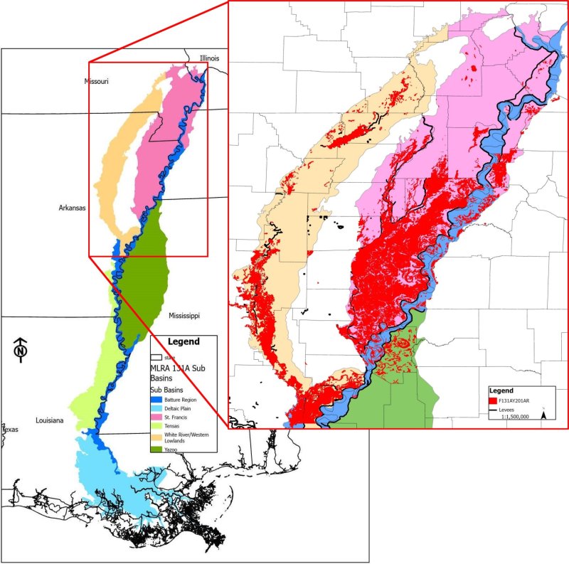
Figure 1. F131AY201AR distribution.
Table 1. Dominant plant species
| Tree |
(1) Quercus lyrata |
|---|---|
| Shrub |
(1) Forestiera acuminata |
| Herbaceous |
(1) Carex |
Click on box and path labels to scroll to the respective text.
Ecosystem states
States 1, 6 and 2 (additional transitions)
States 4, 7 and 8 (additional transitions)
| T1A | - | Construct levees; establish water control structures; develop water supply mechanisms; and prepare drainage system |
|---|---|---|
| T1B | - | Manipulate composition and manage for production (Community 3.1); heavy timber cutting or repeated partial harvests with no management (Community 3.2). |
| T1C | - | Vegetation/stump removal (mechanical/chemical); preparation for cultivation. |
| T1D | - | Vegetation/stump removal (mechanical/chemical); seedbed preparation; establishment of desired forage; manage for grazing. |
| T2A | - | Return to natural flood dynamics; remove levees and water control structures; restore natural hydrology; conduct stand improvements; reestablish and regenerate missing or impacted species. |
| T2B | - | Conduct stand improvements; establish or regenerate desired commercial species; remove levees/obstructions that contribute to prolonged flooding or ponding. |
| T2C | - | Remove vegetation and stumps and control residual plants; remove or modify preexisting impoundment structures; prepare for cultivation |
| T2D | - | Vegetation/stump removal (mechanical/chemical); remove or modify preexisting impoundment structures; seedbed preparation; establishment of desired forage; manage for grazing |
| T3A | - | Reestablish missing species; control exotics (mechanical/chemical); timber stand improvement; natural stand dynamics |
| T3B | - | Construct levees; establish water control structures; develop water supply mechanisms; and prepare drainage system |
| T3C | - | Vegetation/stump removal (mechanical/chemical); preparation for cultivation |
| T3D | - | Vegetation/stump removal (mechanical/chemical); seedbed preparation; establishment of desired forage; manage for grazing. |
| T4A | - | Precision land leveling |
| T4B | - | Vegetation removal (mechanical/chemical); seedbed preparation; establishment of desired forage; manage for grazing. |
| T4C | - | Natural succession (Community 7.1) or prep area (plow pan breakup, fertilizing, etc.); planting species appropriate for site (Community 7.2). |
| T4D | - | Establish select native species suitable for site; prep area for planting (herbicide and/or mechanical). |
| T6A | - | Vegetation/stump removal (mechanical/chemical); preparation for cultivation |
| T6B | - | Natural succession (Community 7.1) or prepare area (e.g., plow pan breakup, fertilizing, etc.) for planting tree species appropriate for site (Afforestation - Community 7.2). |
| T6C | - | Establish select native species suitable for site and prepare area for planting (herbicide and/or mechanical). |
| T7A | - | Vegetation removal (mechanical/chemical) and preparation for cultivation |
| T7B | - | Vegetation/stump removal (mechanical/chemical); seedbed preparation; establishment of desired forage; manage for grazing |
| T8A | - | Vegetation removal (mechanical/chemical) and preparation for cultivation. |
| T8B | - | Establish desired forage species and manage for grazing. |
| T8C | - | Natural succession (Community 7.1) or prepare area (e.g., plow pan breakup, fertilizing, etc.) for planting tree species appropriate for site (Afforestation - Community 7.2). |
State 1 submodel, plant communities
State 2 submodel, plant communities
State 3 submodel, plant communities
| 3.1A | - | Cessation of management followed by heavy cutting or repeated partial harvests |
|---|---|---|
| 3.2A | - | Silvicultural treatments: removal of undesirable species; re-establish species favored in management; timber stand improvement; establish advance regeneration |
State 4 submodel, plant communities
| 4.1A | - | Soil disturbance (tillage); reduction of soil health. |
|---|---|---|
| 4.1B | - | Conventional tillage, seeding, and fertility management for crops. |
| 4.2A | - | No-till, cover crops, reduced till-soil health improvements. |
| 4.2B | - | Conventional tillage, seeding, and fertility management for crops. |
| 4.3A | - | Reduced till, no-till, and cover crops with soil health improvements as a goal. |
State 5 submodel, plant communities
State 6 submodel, plant communities
| 6.1A | - | Seeding and/or management for desired species composition. |
|---|---|---|
| 6.1B | - | Species management without overseeding. |
| 6.2A | - | Seeding, fertilizing, management/removal of undesirable species. |
| 6.2B | - | Species management without overseeding. |
| 6.3A | - | Seeding, fertilizing, management/removal of undesirable species. |
| 6.3B | - | Seeding and/or management for desired species composition. |
| 6.3C | - | Lack of disturbance; no (or infrequent) mowing, herbivory, or brush management; natural succession of woody species. |
| 6.4A | - | Brush management/removal of unwanted species. |
State 7 submodel, plant communities
| 7.1A | - | Remove undesirable competitors; final soil preparation; establish site-appropriate species (favored in management and suitable for planting). |
|---|