Natural Resources
Conservation Service
Ecological site R116AY021MO
Bald Knob Dolomite Glade
Last updated: 6/11/2025
Accessed: 10/20/2025
General information
Provisional. A provisional ecological site description has undergone quality control and quality assurance review. It contains a working state and transition model and enough information to identify the ecological site.
MLRA notes
Major Land Resource Area (MLRA): 116A–Ozark Highland
The Ozark Highlands MLRA is comprised of the Salem Plateau of the Ozark Uplift. Elevation ranges from about 300 feet (91 meters) on the southeast edge of the Ozark escarpment, to about 1,600 feet (488 meters) in the west, adjacent to the Burlington Escarpment of the Springfield Plateau MLRA. The underlying bedrock is mainly horizontally bedded Ordovician-aged dolomites and sandstones that dip gently away from the uplift apex in southeast Missouri. Cambrian dolomites are exposed on deeply dissected hillslopes. In some places, Pennsylvanian and Mississippian sediments overlie the plateau. Relief varies, from the gently rolling Central Plateau Subsection to dissected hillslopes associated with drainageways such as the Current and Eleven Point Rivers (USDA, 2006).
LRU notes
White River Hills Land Resource Unit/White River Hills Subsection
The White River Hills of the Ozark Highland MLRA consists of the deeply dissected portion of the White River drainage basin. White River Hills region lies along the southern flank of the Ozark uplift. Soils are rocky and often thin over limestone and dolomite bedrock. High, rolling divides occur on uplands farthest from the major streams. Dolomite from the Jefferson City-Cotter Formation is unusually resistant to weathering and produces characteristic, rugged dolomite knobs. Many of these knobs are capped by the younger highly weathered remnants of Mississippian-aged cherty limestone formations, resulting in a picturesque uneven skyline reminiscent of mountainous terrain. Pre-settlement vegetation was dominated by extensive dolomite glade and woodland complexes, and oak and pine-oak woodlands and forests. (Nigh and Schroeder, 2002). Dolomite glades in this region, the most extensive in the United States, support numerous rare or endemic species (Ladd et. al., 2006; Nelson et. al., 2013).
Classification relationships
NRCS Land Resource Region N - East and Central Farming and Forest Region; Major Land Resource Area (MLRA), 116A – Ozark Highland; White River Hills Land Resource Unit
USFS Subregions: Ozark Highlands Section (222A); White River Hills Subsection (222Ag)
Community Classification Associations
Terrestrial Natural Community Type in Missouri (Nelson, 2010): The reference state for this ecological site is most like a Dolomite Glade. Minor inclusions/associations with Dolomite Glade can also include Limestone Glade.
National Vegetation Classification System Vegetation Association (NatureServe, 2010):
The reference state for this ecological site is most like the Juniperus ashei/Cotinus obovatus/Carex eburnea - Rudbeckia missouriensis Woodland (CEGL007833, Ozark Ashe′s Juniper Glade Woodland)
Ecological site concept
The Bald Knob Dolomite Glade ecological site is unique and restricted to the White River Hills Subsection of the Ozark Highlands MLRA. Bald Knob Dolomite Glade ecological sites are extensive in the western Ozark Highland on the Ordovician-aged Jefferson City-Cotter formation within the White River watershed. Soils are very shallow to dolomite bedrock. They occur on ridges, gently sloping side slopes and steeper backslopes and are most often in association with chert woodlands above them and dolomite woodlands below them (Nigh and Schroeder, 2002). Cotter dolomite underlies the glades, a substrate which is abnormally resistant to weathering and produces distinctive glade soils unlike most other areas in the Ozark Highlands. These glades occur on all topographical aspects, including north slopes and ridgetops (Figure 1). These ridge-top glades were locally known as bald knobs, the namesake of a group of 19th-century vigilantes (known as the bald knobbers) who would meet at the crest of these treeless knobs to spot potential foes (Steele, 2017). In some locations, these ridge tops are capped by Mississippian limestone. Usually, the limestone component is narrow and quickly transitions from glades to woodland sites. More research is needed to determine if these limestone areas warrant separation into a unique ecological site. The reference plant community ranges from large open areas of native grasses and forbs interspersed with shallow soils and bare bedrock, to areas with shrubs, such as the distinctive American smoketree (Cotinus obovatus) and widely scattered chinkapin oak (Quercus muhlenbergia) and post oak (Q. stellata).
Associated sites
| F116AY048MO |
Chert Dolomite Exposed Backslope Woodland Chert Dolomite Exposed Backslope Woodlands are downslope in places, on southerly and westerly exposures. |
|---|---|
| F116AY010MO |
Calcareous Dolomite Protected Backslope Forest Calcareous Dolomite Protected Backslope Forests are downslope in places, on northerly and easterly exposures. |
| F116AY044MO |
Chert Dolomite Upland Woodland Chert Dolomite Upland Woodlands are often in a complex with Shallow Dolomite Upland Glade/Woodlands and are often upslope. |
| R116AY020MO |
Shallow Dolomite Upland Glade/Woodland Shallow Dolomite Upland Glade/Woodlands are also underlain by dolomite but occur more frequently in the eastern regions of theOzark Highland and are generally much smaller in size. |
| F116AY016MO |
Chert Dolomite Protected Backslope Forest Chert Dolomite Protected Backslope Forests are downslope in places, on northerly and easterly exposures. |
| F116AY047MO |
Calcareous Dolomite Exposed Backslope Woodland Calcareous Dolomite Exposed Backslope Woodlands are downslope in places, on southerly and westerly exposures. |
Similar sites
| R116AY027MO |
Shallow Sandstone Upland Glade/Woodland Shallow Sandstone Upland Glade/Woodlands are underlain by sandstone, resulting in differences in the reference plant community. |
|---|---|
| R116AY020MO |
Shallow Dolomite Upland Glade/Woodland Shallow Dolomite Upland Glade/Woodlands are also underlain by dolomite but occur more frequently in the eastern regions of the Ozark Highland and are generally much smaller in size. |
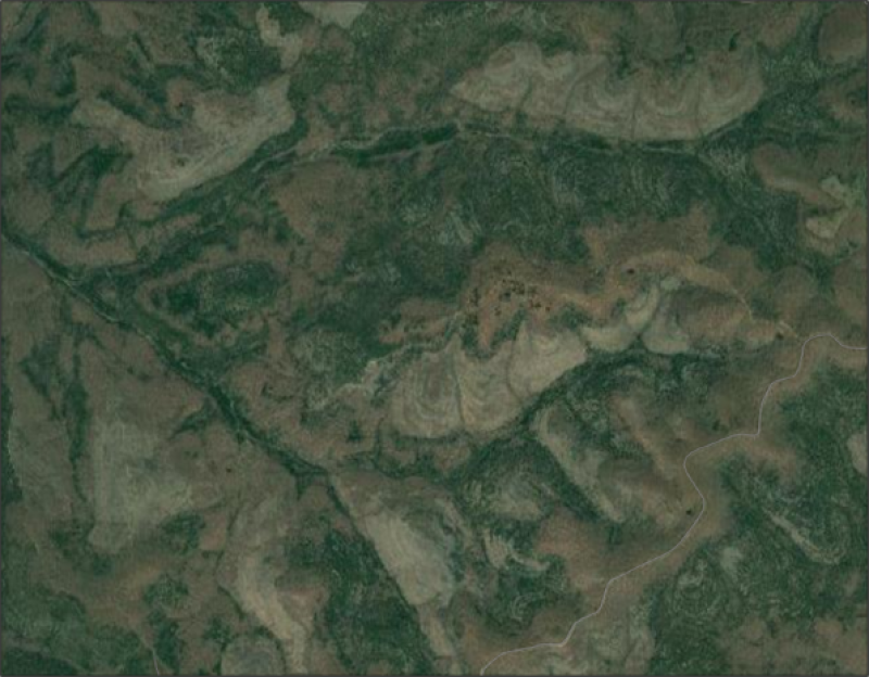
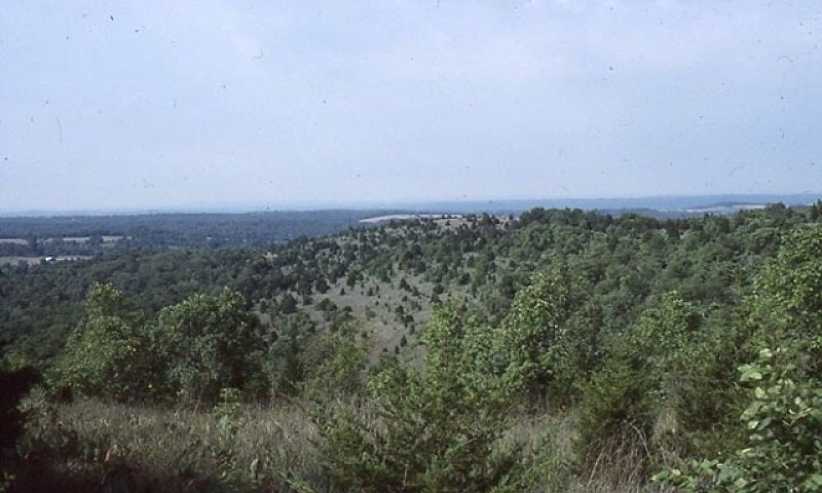
Figure 1. Aerial view of a representative bald knob landscape (Google Maps, accessed April2021) in Hercules Glades Wilderness Area, Mark Twain National Forest, Taney County, MO.
Table 1. Dominant plant species
| Tree |
Not specified |
|---|---|
| Shrub |
(1) Cotinus obovatus |
| Herbaceous |
(1) Schizachyrium scoparium |
Physiographic features
This site is on upland crests, shoulders and backslopes with slopes of 3 to 65 percent (Figures 2 and 3). The site generates runoff to adjacent, downslope ecological sites, and in places receives runoff from upslope summit and shoulder sites. This site does not flood. Figure 2 (adapted from Festervand and Preston, 2005) shows the typical landscape position of this ecological site, and landscape relationships with other ecological sites. It is the areas labeled 1 and 5 in the figure. The dashed lines within the area indicate separations or transitions among the various ecological sites. Bald Knob Dolomite Glade sites are typically associated with Chert Dolomite Woodland and Forest sites, labeled 2, 3, 5. Table 1 displays representative physiographic features based on NRCS pedon data from the National Soil Information System for Bald Knob Dolomite Glade ecological sites.
The schematic shows representative geologic landscape cross-section highlighting landscape relationships with associated ecological sites in the White River Hills subsection. Bald Knob Dolomite Glade sites can transition to a limestone substrate in locations that have a contact with Mississippian geology. The limestone component is typically narrow and quickly transitions from glades to woodland sites. Ordovician-aged Jefferson City-Cotter dolomite, a substrate which is abnormally resistant to weathering, underlies the bald knob glades, producing these distinctive glade communities. Included is a representative Bald Knob Dolomite Glade landscape cross-section in the White River Hills subsection
Figure 4 shows an aerial view of a representative bald knob landscape (Google Maps, accessed April 2021) in Hercules Glades Wilderness Area, Mark Twain National Forest, Taney County, MO. These dome-like glades (light colored, scalloped shaped areas on the map) represent the largest glade openings in the Ozarks and are perhaps the only region in North America where dolomite glades are a dominant matrix community over extensive areas (Nelson and Ladd, 1980).
Aspect: Variable on summits; southeast to southwest on shoulders and backslopes
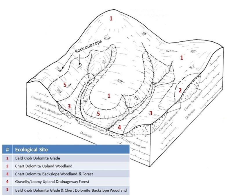
Figure 2. Typical landscape position and landscape relationships of this ecological site
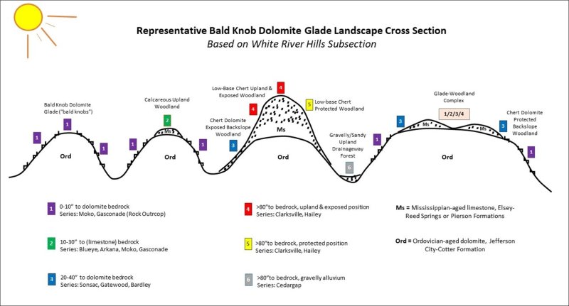
Figure 3. A substrate abnormally resistant to weathering produces the distinctive glade communities.
Table 2. Representative physiographic features
| Hillslope profile |
(1) Summit (2) Shoulder (3) Backslope |
|---|---|
| Landforms |
(1)
Upland
> Hill
(2) Upland > Hillslope (3) Knob (4) Ridge |
| Runoff class | Very high |
| Flooding frequency | None |
| Ponding frequency | None |
| Elevation | 1,000 – 1,380 ft |
| Slope | 3 – 65% |
| Water table depth | 80 in |
| Aspect | Aspect is not a significant factor |
Climatic features
The Ozark Highland has a continental type of climate marked by strong seasonality. In winter, dry-cold air masses, unchallenged by any topographic barriers, periodically swing south from the northern plains and Canada. If they invade reasonably humid air, snowfall, and rainfall result. In summer, moist, warm air masses, equally unchallenged by topographic barriers, swing north from the Gulf of Mexico and can produce abundant amounts of rain, either by fronts or by convectional processes. In some summers, high pressure stagnates over the region, creating extended droughty periods. Spring and fall are transitional seasons when abrupt changes in temperature and precipitation may occur due to successive, fast-moving fronts separating contrasting air masses. (USDA-NRCS, 2006)
Local topographic influences can create topoclimatic, or microclimatic variations. In landscapes of appreciable relief air drainage at nighttime may produce temperatures several degrees lower in valley bottoms than on side slopes. At critical times during the year, this phenomenon may produce later spring or earlier fall freezes in valley bottoms. For example, deep sinkholes often have a microclimate significantly cooler, moister, and shadier than surrounding surfaces, a phenomenon that may result in a strikingly different ecology. Higher daytime temperatures in glades with bare rock surfaces and higher reflectivity of these unvegetated surfaces create distinctive environmental niches. Slope orientation is an important topographic influence on climate. Although this ecological site includes some protected slopes, summits and south-and-west-facing slopes are regularly warmer and drier than adjacent north- and-east-facing slopes. Finally, the climate within a canopied forest is measurably different from the climate of a more open glade, grassland, or savanna areas (Decker, 2021).
Climate data and analyses are derived from 30-year average gathered from five National Oceanic and Atmospheric Administration (NOAA) weather stations contained within the range of this ecological site.
The following tables show selective representative climatic features for the White River Hills region.
Table 3. Representative climatic features
| Frost-free period (characteristic range) | 149-168 days |
|---|---|
| Freeze-free period (characteristic range) | 188-203 days |
| Precipitation total (characteristic range) | 43-47 in |
| Frost-free period (actual range) | 143-175 days |
| Freeze-free period (actual range) | 184-217 days |
| Precipitation total (actual range) | 42-48 in |
| Frost-free period (average) | 159 days |
| Freeze-free period (average) | 197 days |
| Precipitation total (average) | 45 in |
Figure 4. Monthly precipitation range
Figure 5. Monthly minimum temperature range
Figure 6. Monthly maximum temperature range
Figure 7. Monthly average minimum and maximum temperature
Figure 8. Annual precipitation pattern
Figure 9. Annual average temperature pattern
Climate stations used
-
(1) CALICO ROCK 2 WSW [USC00031132], Calico Rock, AR
-
(2) LEAD HILL [USC00034106], Lead Hill, AR
-
(3) MOUNTAIN HOME BAXTER AP [USW00053918], Gassville, AR
-
(4) OZARK BEACH [USC00236460], Forsyth, MO
Influencing water features
Nearly all precipitation leaves this site as runoff, due to the shallow soils and underlying nearly impervious dolomite bedrock. Even though soils are shallow, vegetation sparse, and slopes steep, storm hydrographs show that interflow is a major contributor to total storm runoff. Unlike those from most semi-pervious areas, storm hydrographs have rapid overland flow concentration, sharp peaks, and long tapering overland flow concentration. (Gates et al., 1982). It is possible that a greater amount of overland flow occurs on glade sites with eastern redcedar cover, which would be in part due to loss of the prairie thatch creating exposed soil under eastern redcedar cover. A small amount infiltrates the bedrock along fracture planes, recharging local groundwater and feeding Ozark area springs. Some of this water discharges as glade seeps within the glade itself, adding to ecological complexity (Gates et al., 1982). Management has only a minor effect on this process, as the underlying bedrock is the primary hydrologic barrier. However, increased evapotranspiration from glades with extensive eastern redcedar cover has been shown to dry up glade seeps.
Soil features
The soils are underlain with dolomite bedrock at less than 20 inches (50 cm). In many locations, depth to bedrock is less than 10 inches (25 cm). The soils were formed under prairie vegetation, and have dark, organic-rich surface horizons. Parent material is mixed hillslope sediments, often above dolomite residuum that is weathered in place (Figure 10). These soils are loamy-skeletal or clayey-skeletal, with high amounts of dolomite gravel, channers and flagstones (Festervand and Preston, 2005). They are not affected by seasonal wetness, although glade seeps occur where localized groundwater is discharged. Soils of Bald Knob Dolomite Glade are in the Mollisol order, are well drained to somewhat excessively drained, have very high runoff, and are moderately slowly to moderately permeable.
Soil series associated with this ecological site include:
Gasconade (Clayey-skeletal, mixed, superactive, mesic Lithic Hapludolls)
Knobby (Loamy-skeletal, mixed, superactive, mesic Lithic Hapludolls)
Moko (Loamy-skeletal, mixed, superactive, mesic Lithic Hapludolls)
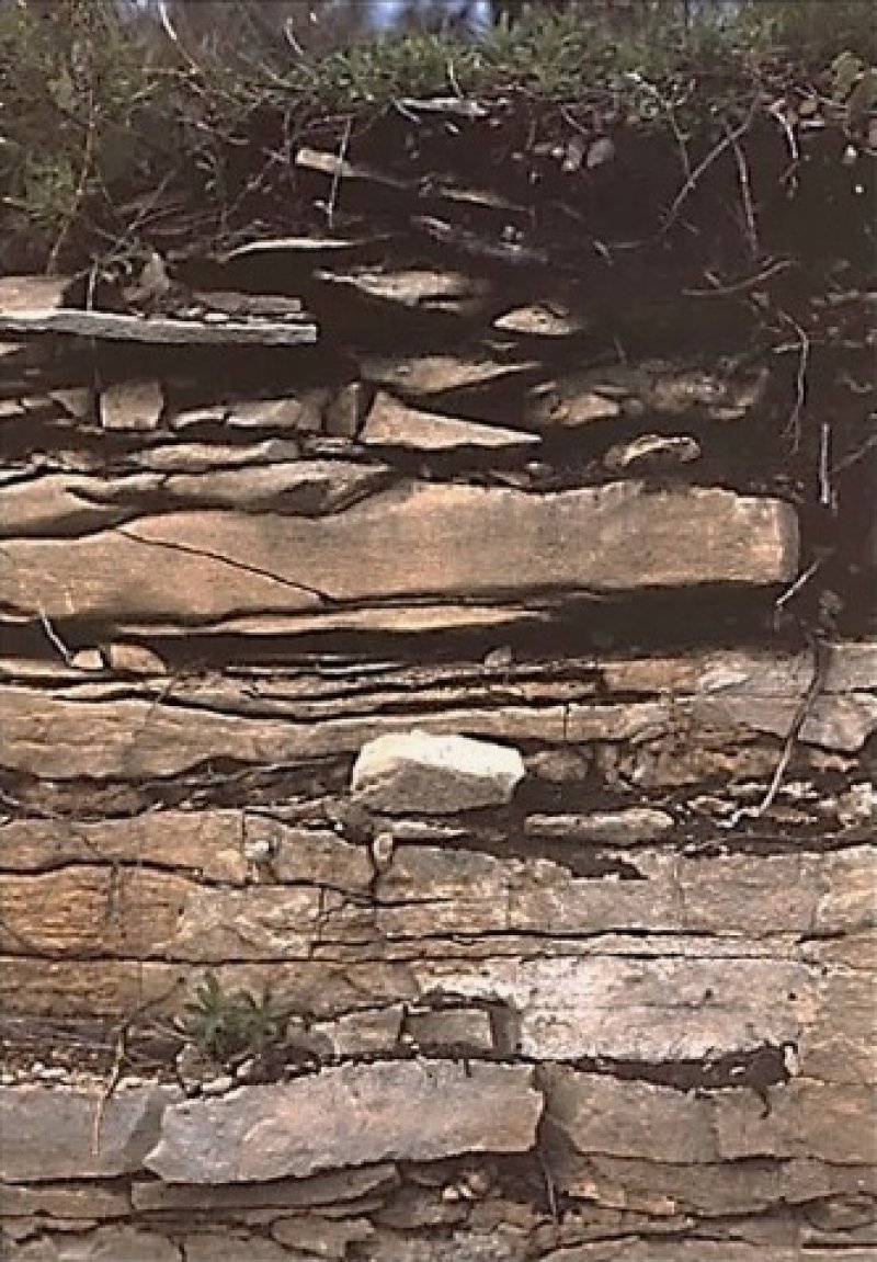
Figure 10. Road cut in the Moko series showing the shallow depth to the fractured dolomite bedrock that characterizes this ecological site. (Photo credit: Baker, NRCS)
Table 4. Representative soil features
| Parent material |
(1)
Residuum
–
dolomite
(2) Slope alluvium – dolomite |
|---|---|
| Surface texture |
(1) Gravelly loam (2) Flaggy, extremely flaggy clay loam |
| Family particle size |
(1) Loamy-skeletal (2) Clayey-skeletal |
| Drainage class | Well drained to somewhat excessively drained |
| Permeability class | Moderately slow to moderate |
| Depth to restrictive layer | 4 – 20 in |
| Soil depth | 4 – 20 in |
| Surface fragment cover <=3" | 7 – 55% |
| Surface fragment cover >3" | 2 – 60% |
| Available water capacity (1-20in) |
1 – 2 in |
| Calcium carbonate equivalent (1-20in) |
1 – 2% |
| Electrical conductivity (1-20in) |
2 mmhos/cm |
| Soil reaction (1:1 water) (1-20in) |
7.2 – 8.1 |
| Subsurface fragment volume <=3" (1-20in) |
5 – 40% |
| Subsurface fragment volume >3" (1-20in) |
5 – 50% |
Ecological dynamics
Bald Knob Dolomite Glades are open, rocky areas with very shallow soils dominated by drought-adapted herbaceous flora, generally occurring on south- and west-facing slopes of otherwise wooded landscapes (Nelson, 2010). However, compared to other glade ecological sites in the Ozarks, Bald Knob Dolomite Glades are the only known glades to occur frequently on north and east facing slopes. Elsewhere, north- and east-facing slopes developed under woodland vegetation. One of the most striking aspects of Bald Knob Dolomite Glades is their unique and characteristic flora which include species endemic to the White River Hills region and other species affiliated with more western mixed native grass prairie (NatureCITE, 2021). Many plants have an affinity for dry calcareous dolomite substrates. Glade plants in general possess many adaptations enabling them to survive in a harsh environment often subject to widely fluctuating extremes of temperature and moisture. The following conditions are generally characteristic of most Bald Knob Dolomite Glades (Nelson and Ladd, 1980; Nelson et al., 2013):
- Calcareous bedrock at or near the surface because of major erosional activity and resistance to weathering.
- Moderate to steep slopes in deeply dissected drainages or hilly to mountainous terrain with a southern or western exposure with intense solar radiation.
- Extremely thin soil cover interspersed with abundant rock fragments and rock outcrops.
- Exceptionally dry conditions throughout much of the growing season, although soils may be seasonally saturated in spring, winter, and fall.
- Peripheral areas and sometimes large expanses of the glades themselves characterized by a mosaic of stunted, often gnarled trees and shrubs.
Fire, drought, frost upheaval, and trampling and browsing from native ungulates such as bison (Bison bison), elk (Cervus canadensis), and white-tailed deer (Odocoileus virginianus) were the primary natural disturbances on pre-settlement glades. It is likely that these sites burned at least once every three to five years with an estimated mean fire frequency of 3.2 years according to tree-ring studies from the period 1730 to 1870 for glades in the White River Hills Subsection (Guyette and McGinnes, 1982). These periodic fires removed the litter and stimulated the growth and flowering of the grasses and forbs. They also limited the growth and dominance of trees, especially eastern redcedar (Juniperus virginiana). Fire tolerant chinkapin oak (Quercus muhlenbergia) and post oak (Q. stellata) occupied islands and edges where the deeper range of the soil component occurred, creating a complex mosaic of open glade and low-density savanna or woodland. During fire-free intervals, woody species increased, but not to the densities of modern day over-grazed or fire-excluded glades.
In the long-term absence of fire, woody species, especially eastern redcedar (Juniperus virginiana), quickly occupy the site. This is especially true after overgrazing has destabilized ecological integrity and reduced grass cover and exposed more surface to the dispersal of redcedar seeds by birds. Once established, eastern redcedar will quickly colonize a glade system, especially if grazing has diminished soil health and the vigor of the diverse flora. Many current glades have been heavily grazed and suffer substantial eastern redcedar invasion along with many exotic species such as sericea lespedeza (Lespedeza cuneata), yellow sweet clover (Melilotus officinale), tall fescue (Schedonorus arundinaceus) and common teasel (Dipsacus fullonum). Sericea lespedeza is the most prominent invasive species representing degraded Bald Knob Dolomite Glades. Removal of the eastern redcedar and the application of herbicides and prescribed fire have proven to be an effective way to manage these systems (Nelson et al., 2013).
Dolomite glades, in general, harbor a wide diversity of plants and animals. Common native grasses that are present include little bluestem, sideoats grama (Bouteloua curtipendula), and prairie dropseed (Sporobolus heterolepis) which are also found in prairies with deeper soil (Nelson et al., 2013). But other species, such as Missouri coneflower (Rudbeckia missouriensis) and limestone calamint (Clinopodium arkansanum) are only found on dolomite glades. Lichens may be locally abundant (Nelson, 2010) such as Russell’s lichen (Psora russellii) and Calkins′ wart lichen (Verrucaria calkinsiana). Desert-adapted animals, like lizards, scorpions, and tarantulas, also occupy healthy glades (Missouri Department of Conservation, 2014; Sexton, 1982). Bald Knob Dolomite Glades have additional unique flora, many of which have a high coefficient of conservatism.
Many of the species inhabiting these glades are considered relicts of the Xerothermic or Hypsithermal period. The climate of Missouri, 8,000 to 4,000 years ago, was hotter and drier. This allowed for more southwestern species to expand into Missouri. Following climate stabilization, the use of fire by indigenous cultures helped retain the composition of the glade ecosystem. As a result of these ecological dynamics, several species have become restricted to glades in the White River Hills region. (MDC, accessed March 2021) These are southwestern species at the eastern edge of their range whose center of distribution is south and west of Missouri include cusp blazing star (Liatris punctata var. mucronata), glade larkspur (Delphinium treleasei), Ashe’s juniper (Juniperus ashei), Arkansas yucca (Yucca arkansana) and American smoketree, along with species of conservation concern such as western soapberry (Sapindus drummondii), umbrella plant (Eriogonum longifolium), and purple tassels prairie clover (Dalea gatt ingeri). (Yatskievych, 1999; Nelson, 2010; Nelson et al., 2013; Nigh and Schroeder, 2002; Baskin and Baskin, 2000; NatureCITE, 2021).
Bald Knob Dolomite Glades also provide valuable habitat for priority or watch-listed bird species, including the field sparrow (Spizella pusilla), brown thrasher (Toxostoma rufum), and painted bunting (Passerina ciris) (Jacobs, 2001). The greater roadrunner (Geococcyx californicus) is the only bird largely restricted to the Bald Knob Dolomite Glades of the White River Hills. Bachman’s sparrow (Aimophila aestivalis) is also sometimes found on dolomite glades. The Texas mouse (Peromyscus attwateri) is the only mammal restricted to glades in Missouri (Schwartz et al., 2001). The eastern collared lizard (Crotaphytus collaris), Texas brown tarantula (Aphonopelma hentzi), and striped bark scorpion (Centruroides vittatus) are all animals whose center of distribution is south and west of Missouri but occur within this ecological site. High quality glade complexes in the White River Hills host some of the largest populations of these species in the Ozarks.
The presence of restricted animals, including insects, presents a challenge when using prescribed burning as a management tool. Today′s intensively altered watersheds (e.g., small tracts, lack of landscape connectivity, public-private conflicts) may impose greater stress on certain plant and animal populations when using fire (Nelson et al., 2013). Regardless, prescribed fire is an important tool for restoring and maintaining the glade habitat for these species, although many of these glade communities are stable and self-assembling intact systems even with infrequent fire (NatureCITE, 2021). Special care should be taken when developing fire prescriptions for restoration purposes.
Finally, of growing concern are the feral hog numbers that are dramatically increasing throughout the Ozark Highlands. Feral hogs dig and overturn extensive vegetation mats on glades looking for insects, reptiles, small mammals, and plant roots. This results in extensive rooting that increases soil erosion and loss of plant and animal species diversity (Figures 12, 13, 14).
Information contained in this section was developed using historical data, professional experience, field reviews, and scientific studies. A State and Transition Diagram follows. Detailed descriptions of each state, transition, plant community, and pathway are included with the model. It is likely to change as knowledge increases.
Plant communities will differ across the MLRA because of the naturally occurring variability in weather, soils, and aspect. The reference plant community is not necessarily the management goal. The species lists are representative and are not intended to cover every situation or the full range of conditions, species, and responses for the site.
State and transition model
Figure 11. Custom State and Transition Model.
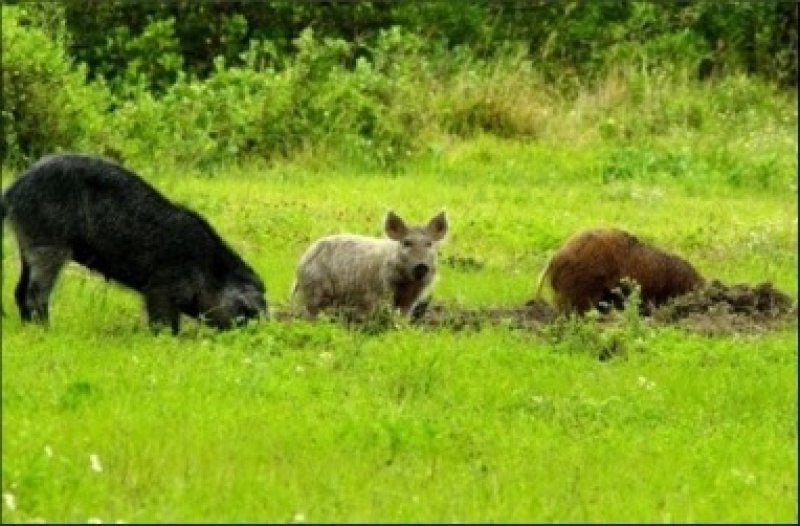
Figure 12. Example of feral hog damage. Photo credit USDA
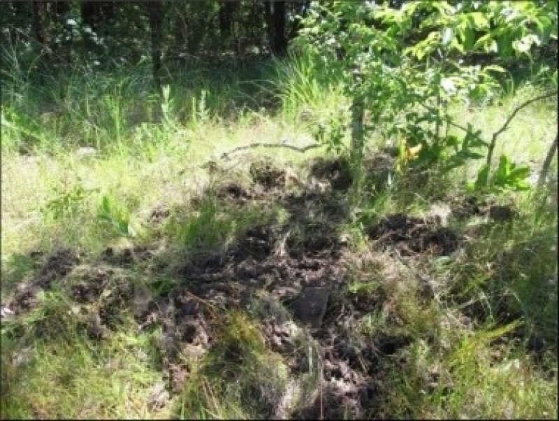
Figure 13. Example of feral hog damage. Photo credit Kyle Steele, USFS
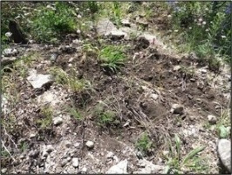
Figure 14. Feral hogs are especially damaging to sensitive natural areas such as glades, fens, and springs. Photo credit Kyle Steele, USFS
More interactive model formats are also available.
View Interactive Models
More interactive model formats are also available.
View Interactive Models
Click on state and transition labels to scroll to the respective text
Ecosystem states
State 2 submodel, plant communities
State 3 submodel, plant communities
State 1
Reference
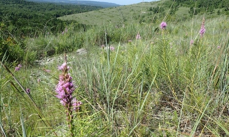
Figure 15. View of 5251-acre Ava Glades Natural Area, Mark Twain National Forest, Ozark County, MO. County reference ecological site: Photo credit: Kyle Steele, USFS
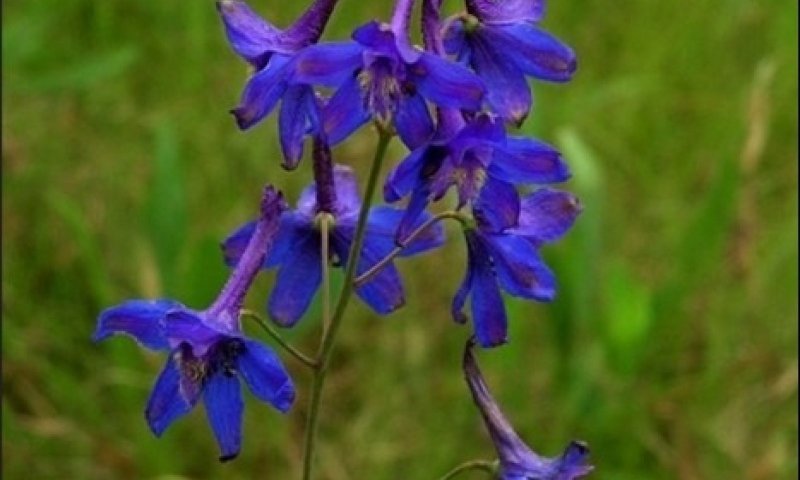
Figure 16. Glade larkspur; photo credit Doug Wallace, NRCS
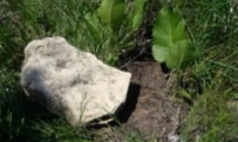
Figure 17. Collectors turn over large boulders and ledge rock (photo credit MDC) to gather invertebrates, snakes, and lizards
Compared to other ecological sites in the Ozarks, Bald Knob Dolomite Glade remnants are common, and in many cases have retained much of their ecological health and quality. The reference state ranges from wide open grassy areas with shallow soils and bare bedrock, to areas with widely scattered chinkapin oak and post oak on locations with soil depths at the deeper extreme of the range for this soil component. On protected slopes and along the outer edges of glades, open woodlands are more common but glades on protected slope still do occur. Periodic disturbances from fire (Guyette and McGinnes, 1982) maintain the dominance of drought adapted native grasses and forbs by limiting the growth and dominance of trees, especially eastern redcedar. Long disturbance-free periods allow an increase in woody species. Maintaining existing glade connectivity (e.g., preventing further glade habitat loss) and increasing landscape connectivity through the restoration of degraded glades will improve conditions for healthy glades. Prescribed fire is an important management tool for maintaining this open and connected glade landscape (Miller et al., 2015) although many of these glade communities are stable and self-assembling intact systems even with infrequent fire (NatureCITE, 2021). Illegal digging of glade plants and collection of animals is also resulting in the degradation of quality glades. Collectors turn over large boulders and ledge rock (Figure 17; photo credit MDC) to gather invertebrates, snakes, and lizards. Digging in glades to collect plants steadily exposes fragile, thin, organic soil, causing erosion and leaving behind more acid gravel and rock debris. Plant species diversity and cover are diminished, and recovery is slow or permanently altered because of drought conditions and species depletion (Nelson et. al.,2013). Two community phases are recognized in this state, with shifts between phases based on fire frequency.
Dominant plant species
-
chinquapin oak (Quercus muehlenbergii), tree
-
dwarf hackberry (Celtis tenuifolia), tree
-
post oak (Quercus stellata), tree
-
American smoketree (Cotinus obovatus), tree
-
leadplant (Amorpha canescens), shrub
-
fragrant sumac (Rhus aromatica), shrub
-
prairie acacia (Acacia angustissima), shrub
-
Ashe's juniper (Juniperus ashei), shrub
-
little bluestem (Schizachyrium scoparium), grass
-
big bluestem (Andropogon gerardii), grass
-
sideoats grama (Bouteloua curtipendula), grass
-
Mead's sedge (Carex meadii), grass
-
cusp blazing star (Liatris punctata var. mucronata), other herbaceous
-
hairy lipfern (Cheilanthes lanosa), other herbaceous
-
limestone adderstongue (Ophioglossum engelmannii), other herbaceous
-
purple cliffbrake (Pellaea atropurpurea), other herbaceous
Dominant resource concerns
-
Sheet and rill erosion
-
Ephemeral gully erosion
Community 1.1
American Smoketree/Little Bluestem - Cusp Blazing Star
This phase is dominated by drought-adapted herbaceous flora and includes species only endemic to the White River Hills Subsection and others affiliated with more western mixed native grass prairie. Many plants have an affinity for dry calcareous dolomite substrates. Lichens may be locally abundant along with desert-adapted animals, like lizards, scorpions, and tarantulas.
Dominant plant species
-
American smoketree (Cotinus obovatus), tree
-
little bluestem (Schizachyrium scoparium), grass
-
cusp blazing star (Liatris punctata var. mucronata), other herbaceous
Dominant resource concerns
-
Sheet and rill erosion
-
Wildfire hazard from biomass accumulation
Community 1.2
American Smoketree/Fragrant Sumac - Leadplant /Little Bluestem – Cusp Blazing Star
This phase has an increase in shrubby species such as fragrant sumac and leadplant due less frequent fire frequencies especially on soil depths at the deeper extreme of the range for this soil component and on protected slopes and along the outer edges of the glades. The forb and native grasses species component are not affected and still closely resembles community phase 1.1 although some specie density decline may occur.
Dominant plant species
-
chinquapin oak (Quercus muehlenbergii), tree
-
American smoketree (Cotinus obovatus), tree
-
leadplant (Amorpha canescens), shrub
-
fragrant sumac (Rhus aromatica), shrub
-
little bluestem (Schizachyrium scoparium), grass
-
cusp blazing star (Liatris punctata var. mucronata), other herbaceous
Dominant resource concerns
-
Sheet and rill erosion
-
Wildfire hazard from biomass accumulation
Pathway 1.1A
Community 1.1 to 1.2
Longer fire-free intervals of 5 to 10 years will increase woody species density and cover causing the community to gradually shift to phase1.2. Some displacement of grasses and forbs may be occurring due to shading, thatch buildup, and competition from the increased densities of eastern redcedar, shrubs and oaks.
Pathway 1.2A
Community 1.2 to 1.1
With increased fire frequencies, woody species will decrease in density and canopy cover. Over time this community, because of increase fire frequency, will gradually shift back to community phase 1.1 with improved ground cover and species densities.
State 2
Woody Invaded Glade
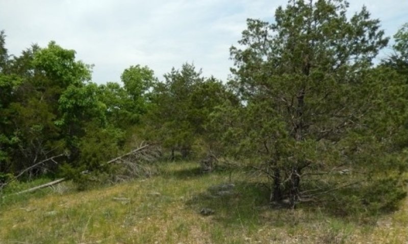
Figure 18. A dolomite glade in Arkansas experiencing eastern redcedar invasion after long term fire suppression; Photo credit: Doug Wallace, NRCS
This state and community phase is dominated by eastern redcedar due to extended or permanent periods of fire suppression (Figure 18). This state can form relatively even-age stands, dating to when fire suppression began, often coupled with removal of livestock. This stage can occur relatively quickly (15 to 20 years). Over time, canopy closures can approach 60 to 80 percent with little or no ground flora under the overstory canopy. Without active management, such as prescribed fire and woody removal, these sites will continue increasing in canopy coverage except on the shallowest soil and open bedrock areas where droughty conditions often keep woody invasion in check. Most Bald Knob Dolomite Glade ecological sites throughout its range are currently in this state.
Dominant plant species
-
eastern redcedar (Juniperus virginiana), tree
-
little bluestem (Schizachyrium scoparium), grass
Dominant resource concerns
-
Plant productivity and health
-
Plant structure and composition
-
Wildfire hazard from biomass accumulation
-
Terrestrial habitat for wildlife and invertebrates
Community 2.1
Eastern Redcedar/Little Bluestem

Figure 19. Hayden Bald Natural Area in 1990, looking north, showing eastern redcedar invading the site; Photo credit: Forest Service
This community phase is dominated by eastern redcedar due to extended or permanent periods of fire suppression (Figure 19). This state can form relatively even-age stands, dating to when fire suppression began, often coupled with removal of livestock. This stage can occur relatively quickly (15 to 20 years). Over time, canopy closures can approach 60 to 80 percent with little or no ground flora under the overstory canopy. Without active management, such as prescribed fire and woody removal, these sites will continue increasing in canopy coverage except on the shallowest soil and open bedrock areas where droughty conditions often keep woody invasion in check. Many Bald Knob Dolomite Glade ecological sites throughout its range are currently in this state.
Dominant plant species
-
eastern redcedar (Juniperus virginiana), tree
-
little bluestem (Schizachyrium scoparium), grass
Dominant resource concerns
-
Sheet and rill erosion
-
Ephemeral gully erosion
-
Plant productivity and health
-
Plant structure and composition
-
Wildfire hazard from biomass accumulation
-
Terrestrial habitat for wildlife and invertebrates
State 3
Grazed Glade
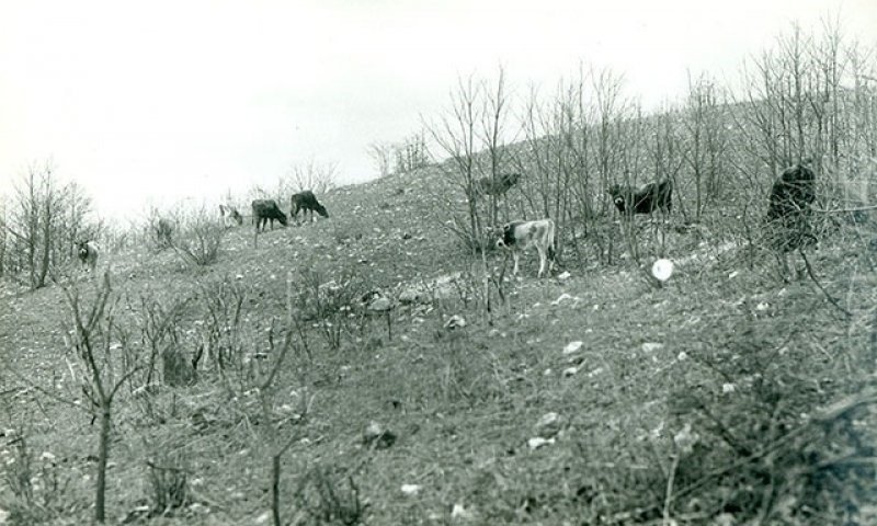
Figure 20. Livestock grazing on a bald knob glade in the spring of 1939 showing severe ground cover disturbance; photo credit Forest Service.
Decades of overgrazing (Figure 20) have eroded the shallow, fragile, original soil layer from glades (Nelson and Ladd, 1980; Erickson et al.,1942). This overgrazing has decreased the number and diversity of species and has caused changes in the distribution of opportunistic and conservative glade species. Grazing activities reduce the quality of glade habitats through soil compaction and the selective removal of plant species. Two phases occur in this state with shifts between phases based on intensity of grazing and management inputs.
Dominant plant species
-
eastern redcedar (Juniperus virginiana), tree
-
winged elm (Ulmus alata), shrub
-
cheatgrass (Bromus tectorum), grass
-
sericea lespedeza (Lespedeza cuneata), other herbaceous
Community 3.1
Eastern Redcedar – Winged Elm/Cheatgrass – Sericea Lespedeza
This phase represents an actively grazed disturbed glade and has increased densities of eastern redcedar and shrubs. Other weedyspecies such as non-native invasive grasses and forbs, such as sweetclover (Melilotus spp.), cheatgrass (Bromus tectorum), commonteasel (Dipsacus fullonum), and sericea lespedeza (Lespedeza cuneata), also increase (Ladd, et.al, 2006). Overgrazing (Figure 20) willdecrease the number and diversity of species and cause changes in the distribution of opportunistic and conservative glade species (Erickson et al., 1942). Recovery of the once deeper, now eroded soils and their former diverse cover of perennial grasses, sedges andwildflowers is extremely difficult and time consuming. The significant disturbances that caused this phase may represent permanentdegradation and an inability to transition to other states (Nelson, et. al., 2013).
Dominant plant species
-
eastern redcedar (Juniperus virginiana), tree
-
winged elm (Ulmus alata), shrub
-
cheatgrass (Bromus tectorum), grass
-
sericea lespedeza (Lespedeza cuneata), other herbaceous
Dominant resource concerns
-
Sheet and rill erosion
-
Ephemeral gully erosion
-
Terrestrial habitat for wildlife and invertebrates
Community 3.2
Tall Fescue
In some cases, these glade systems have been converted into managed pastures following establishment of non-native grasses using brush control, grassland management, grassland planting, and prescribed grazing. In these situations, native trees and shrubs will be removed and native grass/forb cover replaced with non-native introduced tall fescue (Schedonorus arundinaceus). Pasture herbicides, when used, will also remove native vegetation. The use of heavy equipment during this conversion severely damages surface soils and promotes significant soil loss from the site.
Dominant plant species
-
tall fescue (Schedonorus arundinaceus), grass
Dominant resource concerns
-
Compaction
-
Organic matter depletion
-
Pathogens and chemicals from manure, biosolids, or compost applications transported to ground water
-
Plant productivity and health
-
Plant structure and composition
-
Terrestrial habitat for wildlife and invertebrates
-
Feed and forage imbalance
Pathway 3.1A
Community 3.1 to 3.2
Removing woody cover and converting these glades into managed pastures with non-native grasses and forbs will transition this phase to Community Phase 3.2.
Pathway 3.2A
Community 3.2 to 3.1
Cessation of grassland management activities, while allowing uncontrolled domestic grazing to continue will transition this phase back to Community Phase 3.1.
Transition T1A
State 1 to 2
This gradual transition to a Woody Invaded Glade state results from prolonged periods of fire suppression, generally over 20 years. Sites in this condition may also have received historic cattle grazing, adding to the potential for eastern redcedar invasion and site disturbance.
Transition T1B
State 1 to 3
Transition to a Grazed Glade state results from persistent grazing by domestic livestock accompanied by fire suppression, woody invasion or woody clearing and conversion to non-native, cool-season pasture.
Restoration pathway R2A
State 2 to 1
This reference state restoration pathway requires removal of most of the invading woody species such as eastern redcedar, accompanied by prescribed fire on a continuing basis.
Conservation practices
| Brush Management | |
|---|---|
| Prescribed Grazing | |
| Restoration and Management of Rare and Declining Habitats |
Transition T2A
State 2 to 3
This transition to a Grazed Glade state results from prolonged periods of fire suppression and the introduction of grazing by domestic livestock. These dynamics are also often accompanied by reseeding with non-native grasses creating soil disturbance to support modern grazing systems.
Restoration pathway R3A
State 3 to 1
This reference state restoration pathway requires exclusion of livestock grazing, accompanied by prescribed burning and brush management. The infestations of invasive plant species can be controlled using integrated techniques which include woody removal, the selective use of herbicides and prescribed fire. Reseeding with native grasses and forbs may be necessary to off-set severe infestations of exotic plants or opportunistic native woody species. If grazing activities have been extensive for long periods of time, recovery to a reference state may be impossible.
Conservation practices
| Brush Management | |
|---|---|
| Prescribed Grazing | |
| Restoration and Management of Rare and Declining Habitats |
Additional community tables
Table 5. Community 1.1 forest overstory composition
| Common name | Symbol | Scientific name | Nativity | Height (ft) | Canopy cover (%) | Diameter (in) | Basal area (square ft/acre) |
|---|---|---|---|---|---|---|---|
|
Tree
|
|||||||
| Lady Bird's centaury | CETE2 | Centaurium texense | Native | – | 0–10 | – | – |
| American smoketree | COOB2 | Cotinus obovatus | Native | – | 0–10 | – | – |
| chinquapin oak | QUMU | Quercus muehlenbergii | Native | – | 0–10 | – | – |
| post oak | QUST | Quercus stellata | Native | – | 0–10 | – | – |
Table 6. Community 1.1 forest understory composition
| Common name | Symbol | Scientific name | Nativity | Height (ft) | Canopy cover (%) | |
|---|---|---|---|---|---|---|
|
Grass/grass-like (Graminoids)
|
||||||
| big bluestem | ANGE | Andropogon gerardii | Native | – | 5–20 | |
| sideoats grama | BOCU | Bouteloua curtipendula | Native | – | 5–20 | |
| Mead's sedge | CAME2 | Carex meadii | Native | – | 5–20 | |
| little bluestem | SCSC | Schizachyrium scoparium | Native | – | 5–20 | |
| Indiangrass | SONU2 | Sorghastrum nutans | Native | – | 5–20 | |
| prairie dropseed | SPHE | Sporobolus heterolepis | Native | – | 5–20 | |
| Ozark dropseed | SPVAO | Sporobolus vaginiflorus var. ozarkanus | Native | – | 1–5 | |
|
Forb/Herb
|
||||||
| slimleaf milkweed | ASST | Asclepias stenophylla | Native | – | 1–5 | |
| butterfly milkweed | ASTU | Asclepias tuberosa | Native | – | 1–5 | |
| green comet milkweed | ASVI | Asclepias viridiflora | Native | – | 1–5 | |
| groundplum milkvetch | ASCRT | Astragalus crassicarpus var. trichocalyx | Native | – | 1–5 | |
| Ozark milkvetch | ASDI4 | Astragalus distortus | Native | – | 1–5 | |
| blue wild indigo | BAAU | Baptisia australis | Native | – | 1–5 | |
| Alabama supplejack | BESC | Berchemia scandens | Native | – | 1–5 | |
| American bluehearts | BUAM | Buchnera americana | Native | – | 1–5 | |
| Texas greeneyes | BEBE4 | Berlandiera betonicifolia | Native | – | 1–5 | |
| Atlantic camas | CASC5 | Camassia scilloides | Native | – | 1–5 | |
| scarlet Indian paintbrush | CACO17 | Castilleja coccinea | Native | – | 1–5 | |
| Lady Bird's centaury | CETE2 | Centaurium texense | Native | – | 1–5 | |
| limestone calamint | CLAR5 | Clinopodium arkansanum | Native | – | 1–5 | |
| scarlet Indian paintbrush | CACO17 | Castilleja coccinea | Native | – | 1–5 | |
| Lady Bird's centaury | CETE2 | Centaurium texense | Native | – | 1–5 | |
| limestone calamint | CLAR5 | Clinopodium arkansanum | Native | – | 1–5 | |
| lanceleaf tickseed | COLA5 | Coreopsis lanceolata | Native | – | 1–5 | |
| stiff tickseed | COPA10 | Coreopsis palmata | Native | – | 1–5 | |
| Michaux's croton | CRMIE | Croton michauxii var. ellipticus | Native | – | 1–5 | |
| white prairie clover | DACA7 | Dalea candida | Native | – | 1–5 | |
| purple prairie clover | DAPU5 | Dalea purpurea | Native | – | 1–5 | |
| Carolina larkspur | DECA3 | Delphinium carolinianum | Native | – | 1–5 | |
| glade larkspur | DETR3 | Delphinium treleasei | Native | – | 1–5 | |
| pride of Ohio | DOME | Dodecatheon meadia | Native | – | 1–5 | |
| blacksamson echinacea | ECAN2 | Echinacea angustifolia | Native | – | 1–5 | |
| pale purple coneflower | ECPA | Echinacea pallida | Native | – | 1–5 | |
| Bush's purple coneflower | ECPA2 | Echinacea paradoxa | Native | – | 1–5 | |
| button eryngo | ERYU | Eryngium yuccifolium | Native | – | 1–5 | |
| longleaf buckwheat | ERLO5 | Eriogonum longifolium | Native | – | 1–5 | |
| shaggy dwarf morning-glory | EVNU | Evolvulus nuttallianus | Native | – | 1–5 | |
| downy gentian | GEPU5 | Gentiana puberulenta | Native | – | 1–5 | |
| ashy sunflower | HEMO2 | Helianthus mollis | Native | – | 1–5 | |
| stiff sunflower | HEPA19 | Helianthus pauciflorus | Native | – | 1–5 | |
| willowleaf sunflower | HESA2 | Helianthus salicifolius | Native | – | 1–5 | |
| pasture heliotrope | HETE3 | Heliotropium tenellum | Native | – | 1–5 | |
| common goldstar | HYHI2 | Hypoxis hirsuta | Native | – | 1–5 | |
| Michaux's gladecress | LEUN | Leavenworthia uniflora | Native | – | 1–5 | |
| tall blazing star | LIAS | Liatris aspera | Native | – | 1–5 | |
| Ontario blazing star | LICY | Liatris cylindracea | Native | – | 1–5 | |
| cusp blazing star | LIPUM2 | Liatris punctata var. mucronata | Native | – | 1–5 | |
| scaly blazing star | LISQ | Liatris squarrosa | Native | – | 1–5 | |
| hoary puccoon | LICA12 | Lithospermum canescens | Native | – | 1–5 | |
| false aloe | MAVI5 | Manfreda virginica | Native | – | 1–5 | |
| Dixie stitchwort | MIMU6 | Minuartia muscorum | Native | – | 1–5 | |
| bigfruit evening primrose | OEMA | Oenothera macrocarpa | Native | – | 1–5 | |
| prairie goldenrod | OLAL2 | Oligoneuron album | Native | – | 1–5 | |
| devil's-tongue | OPHU | Opuntia humifusa | Native | – | 1–5 | |
| Sampson's snakeroot | ORPE | Orbexilum pedunculatum | Native | – | 1–5 | |
| small palafox | PACA3 | Palafoxia callosa | Native | – | 1–5 | |
| wild quinine | PAHI8 | Parthenium hispidum | Native | – | 1–5 | |
| wild quinine | PAIN3 | Parthenium integrifolium | Native | – | 1–5 | |
| cobaea beardtongue | PECO4 | Penstemon cobaea | Native | – | 1–5 | |
| largeflower fameflower | PHCA48 | Phemeranthus calycinus | Native | – | 1–5 | |
| Ozark phlox | PHPIO2 | Phlox pilosa ssp. ozarkana | Native | – | 1–5 | |
| Missouri orange coneflower | RUMI | Rudbeckia missouriensis | Native | – | 1–5 | |
| fringeleaf wild petunia | RUHU | Ruellia humilis | Native | – | 1–5 | |
| wholeleaf rosinweed | SIIN2 | Silphium integrifolium | Native | – | 1–5 | |
| prairie rosinweed | SITE | Silphium terebinthinaceum | Native | – | 1–5 | |
| prairie blue-eyed grass | SICA9 | Sisyrinchium campestre | Native | – | 1–5 | |
| Gattinger's goldenrod | SOGA | Solidago gattingeri | Native | – | 1–5 | |
| western rough goldenrod | SORA | Solidago radula | Native | – | 1–5 | |
| showy goldenrod | SOSPS4 | Solidago speciosa var. speciosa | Native | – | 1–5 | |
| diamondflowers | STNIN | Stenaria nigricans var. nigricans | Native | – | 1–5 | |
| false gaura | STLI2 | Stenosiphon linifolius | Native | – | 1–5 | |
| smooth blue aster | SYLA3 | Symphyotrichum laeve | Native | – | 1–5 | |
| aromatic aster | SYOB | Symphyotrichum oblongifolium | Native | – | 1–5 | |
| skyblue aster | SYOO | Symphyotrichum oolentangiense | Native | – | 1–5 | |
| western silver aster | SYSE2 | Symphyotrichum sericeum | Native | – | 1–5 | |
| birdfoot violet | VIPE | Viola pedata | Native | – | 1–5 | |
|
Fern/fern ally
|
||||||
| hairy lipfern | CHLA2 | Cheilanthes lanosa | Native | – | 1–5 | |
| purple cliffbrake | PEAT2 | Pellaea atropurpurea | Native | – | 1–5 | |
| limestone adderstongue | OPEN | Ophioglossum engelmannii | Native | – | 1–5 | |
|
Shrub/Subshrub
|
||||||
| prairie acacia | ACAN11 | Acaciella angustissima | Native | – | 1–5 | |
| leadplant | AMCA6 | Amorpha canescens | Native | – | 1–5 | |
| Ashe's juniper | JUAS | Juniperus ashei | Native | – | 1–5 | |
| fragrant sumac | RHAR4 | Rhus aromatica | Native | – | 1–5 | |
| western soapberry | SASAD | Sapindus saponaria var. drummondii | Native | – | 1–5 | |
| gum bully | SILA20 | Sideroxylon lanuginosum | Native | – | 1–5 | |
| Arkansas yucca | YUAR2 | Yucca arkansana | Native | – | 1–5 | |
| Missouri maidenbush | PHPH9 | Phyllanthopsis phyllanthoides | Native | – | 1–5 | |
|
Biological Crusts
|
||||||
| fishscale lichen | PSDE60 | Psora decipiens | Native | – | 0–5 | |
| Russell's fishscale lichen | PSRU3 | Psora russellii | Native | – | 0–5 | |
| Calkins' wart lichen | VECA14 | Verrucaria calkinsiana | Native | – | 0–5 | |
| Schaerer's psorotichia lichen | PSSC9 | Psorotichia schaereri | Native | – | 0–5 | |
Interpretations
Animal community
Wildlife
Wildlife habitat: oaks provide hard mast; numerous native legumes provide high-quality wildlife food; native warm-season grasses provide extensive cover and nesting habitat; and a diversity of forbs provides a diversity and abundance of insects. Post-burn areas can provide temporary bare-ground – herbaceous cover habitat important for turkey poults and quail chicks.
Game species that utilize this ecological site include (Pitts and McGuire, 2000; Schwartz et al., 2001):
Northern Bobwhite will utilize this ecological site for food (seeds, insects), cover needs (escape, nesting, and roosting cover) and brood-rearing habitat.
Eastern cottontail rabbit (Sylvilagus floridanus) will utilize this ecological site for food (seeds, soft mast) and cover needs.
Turkey will utilize this ecological site for food (seeds, green browse, soft mast, and insects) and nesting and brood-rearing cover. Turkey poults feed heavily on insects provided by this site type.
White-tailed deer (Odocoileus virginianus) will utilize this ecological site for browse (plant leaves in the growing season, seeds, and soft mast in the fall/winter).
The follow species lists are associated with this ecological site’s reference state condition:
Breeding birds: Field Sparrow, Yellow-breasted Chat, Blue-winged Warbler, Brown Thrasher, Indigo Bunting, Red-headed Woodpecker, Eastern Bluebird, Northern Bobwhite, Prairie Warbler, and Eastern Towhee, Painted Bunting, Greater Roadrunner, Bachman’s Sparrow, Blue-gray Gnatcatcher, Chipping Sparrow, Summer Tanager, White-eyed Vireo, and Yellow-billed Cuckoo. (Fitzgerald and Pashley, 2000a; Jacobs, 2001)
Amphibians and reptiles: eastern collared lizard (Crotaphytus collaris collaris), five-lined skink (Eumeces fasciatus), six-lined racerunner (Cnemidophorus sexlineatus), flat-headed snake (Tantilla gracilis), eastern coachwhip (Masticophis flagellum flagellum), red milk snake (Lampropeltis triangulum syspila), eastern narrow-mouthed toad (Gastrophyne carolinensis), southern coal skink (Eumeces anthracinus pluvialis), variable ground snake (Snora semiannulata), western pygmy rattlesnake (Sistrurus miliarius streckeri), great plains ratsnake (Elaphe emoryi), prairie lizard (Sceloporus consobrinus), prairie racerunner (Cnemidophorus sexlineatus viridis), rough earth snake (Haldea striatula), western smooth earth snake (Virginia valeriae), and prairie ring-necked snake (Diadophis punctatus arnyi). (Johnson, 2000)
Small mammals: eastern woodrat (Neotoma floridana) and Peromyscus species. In the White River watershed, the Texas mouse (Peromyscus attwateri) occurs. (Schwartz et al., 2001)
Insects: Many native insect species groups are common, especially native bees, ants, beetles, butterflies and moths, and crickets, grasshoppers, and katydids.
Specific species include: dusted skipper butterfly (Atrytonopsis hianna), cobweb skipper butterfly (Hesperia metea), pepper and salt skipper butterfly (Amblyscirtes hegon), delaware skipper butterfly (Atryone logan logan), crossline skipper butterfly (Polites origenes), native ants (Pheidole tysoni, Formica schaufussi), and native bees (Colletes aestivalis, Andrena helianthiformis, Protandrena rudbeckiae, Lasioglossum coreopsis, Anthidium psoraleae and Dianthidium subrufulum). The largest tiger beetle in the state occurs on these sites, Cicindela obsoleta vulturina. (Heitzman and Heitzman, 1996)
Other invertebrates: black widow spider (Latrodectus mactans), Texas brown tarantula (Aphonopelma hentzi) and striped bark scorpion (Centruroides vittatus)
Forestry
- Management: Field measured site index values are 22 to 34 for eastern redcedar and 34 to 38 for chinkapin oak (NRCS, 2014). While most glade ecological sites harbor significant eastern redcedar populations, only the Bald Knob Dolomite Glades support a perpetuating timber industry. Missouri has the fourth largest eastern redcedar resource in the United States, and demand is increasing rapidly along with prices. A 2004 study by the University of Missouri Center for Agroforestry market research determined that eastern redcedar was a $60 million dollar industry with a rapidly expanding national market. Many high-value products can be produced from small-diameter stock, and eastern redcedar's natural rot and insect resistance makes it an attractive substitute for pressure-treated lumber products (Jenkins, 2004) These sites are also valuable for wildlife purposes and watershed protection. Severely reduced rooting depth restricts tree growth and increases windthrow hazards. These sites respond well to prescribed fire as a management tool.
- Limitations: Surface stones and surface rock; very shallow soil depth; steep slopes. Surface stones and rocks are problems for efficient and safe equipment operation. Severe seedling mortality due to high soil surface temperatures and low available water holding capacity is possible. Machine planting and mechanical site preparation is not recommended. Hard bedrock at shallow depths may interfere with equipment operation. Rock outcrops may cause breakage of timber when harvesting. Surface stones and rocks will make equipment use extremely difficult. Erosion is a hazard when slopes exceed 15 percent. Equipment use is not recommended. (NRCS, 2002)
Wood products
Forest Management: Field measured site index values are 22 to 34 for eastern redcedar and 34 to 38 for chinkapin oak (NRCS, 2014). While most glade ecological sites harbor significant eastern redcedar populations, only the Bald Knob Dolomite Glades support a perpetuating timber industry. Missouri has the fourth largest eastern redcedar resource in the United States, and demand is increasing rapidly along with prices. A 2004 study by the University of Missouri Center for Agroforestry market research determined that eastern redcedar was a 60-million-dollar industry in the with a rapidly expanding national market. Many high-value products can be produced from small-diameter stock, and eastern redcedar's natural rot and insect resistance makes it an attractive substitute for pressure-treated lumber products (Jenkins, 2004) These sites are also valuable for wildlife purposes and watershed protection. Severely reduced rooting depth restricts tree growth and increases windthrow hazards. These sites respond well to prescribed fire as a management tool.
Other information
Site Limitations: Surface stones and surface rock; very shallow soil depth; steep slopes. Surface stones and rocks are problems for efficient and safe equipment operation. Severe seedling mortality due to high soil surface temperatures and low available water holding capacity is possible. Machine planting and mechanical site preparation is not recommended. Hard bedrock at shallow depths may interfere with equipment operation. Rock outcrops may cause breakage of timber when harvesting. Surface stones and rocks will make equipment use extremely difficult. Erosion is a hazard when slopes exceed 15 percent. Equipment use is not recommended. (NRCS, 2002)
Supporting information
Inventory data references
The data contained in this document is derived from analysis of inventories, ecological interpretation from field evaluations, sampling of plots/transects/releve, and various reference papers and books. Destructive plant sampling was not allowed on the public reference sites. Site index information on woody species was collected to provide estimates of site productivity.
Other references
Anderson, R.C. 1990. The historic role of fire in North American grasslands. In: S.L. Collins and L.L. Wallace (editors). Fire in North American tallgrass prairies. University of Oklahoma Press, Norman. p. 8-18.
Baskin, J.M., and C.C. Baskin. 2000. Vegetation of Limestone and Dolomite Glades in the Ozarks and Midwest Regions of the United States. Annals of the Missouri Botanical Garden 87(2): 286-94. Retrieved March 17, 2021.
Batek, M.J., A.J. Rebertus, W.A. Schroeder, T.L. Haithcoat, E. Compas, and R.P. Guyette. 1999. Reconstruction of early nineteenth-century vegetation and fire regimes in the Missouri Ozarks. Journal of Biogeography p. 397-412.
Decker, W.L. 2011. Climate of Missouri. University of Missouri Climate Center. Retrieved April 2021. http://climate.missouri.edu/climate.php
Erickson, R.O., L.G. Brenner, and J. Wraight. 1942. Dolomitic glades of east-central Missouri. Annals of the Missouri Botanical Garden 29 (2): 89-101.
Festervand, D.F. and J.D. Preston. 2005. Soil Survey of Ozark County, Missouri. United States Department of Agriculture Natural Resources Conservation Service.
Fitzgerald, J.A. and D.N. Pashley. 2000. Partners in Flight bird conservation plan for the Ozark/Ouachitas (Physiographic Area 19). American Bird Conservancy. Washington, DC.
Gates, J. A., M., C.D. Settergren, G.S. Henderson, and J.J. Krstansky. 1982. Hydrology of a south-central Missouri cedar glade. In: E. G. Kruse, D. R. Burdick, and Y. A. Yousef (editors) Environmentally Sound Water and Soil Management, Orlando, Florida, 21-23 July 1982. American Society of Civil Engineers, New York, NY. p 36-41.
Guyette, R.P. and E.A. McGinnes, Jr. 1982. Fire history of an Ozark glade in Missouri.
Transactions of the Missouri Academy of Science 16:85-89.
Harlan, J.D., T.A. Nigh and W.A. Schroeder. 2001. The Missouri original General Land Office survey notes project. University of Missouri, Columbia.
Heitzman, J.R. and J.E. Heitzman. 1996. Butterflies and moths of Missouri. 2nd ed. Missouri Department of Conservation, Jefferson City.
Jacobs, B. 2001. Birds in Missouri. Missouri Department of Conservation, Jefferson City.
Janowski-Bell, M.E. 2001. Ecology of an American tarantula, Aphonopelma hentzi (Girard) (Theraphosidae). Ph.D. dissertation, University of Missouri, Columbia.
Jenkins J. 2004. From trash to cash: UMCA explores profitable Eastern Red Cedar Market. Green Horizons (Quarterly newsletter of the University of Missouri Center for Agroforestry and the College of Agriculture, Food, and Natural Resources) 8(2). http://agebb.missouri.edu/agforest/archives/v8n2/gh6.htm
Johnson, T. R. 2000. The amphibians and reptiles of Missouri. 2nd ed. Missouri Department of Conservation, Jefferson City.
Ladd, D., A. Brown, and B. Heumann. 2006. Presettlement vegetation and rapid ecological assessment of glade landscapes in the Ava region, Mark Twain National Forest. The Nature Conservancy, Missouri Field Office, St. Louis, MO.
Ladd, D., and J. R. Thomas. 2015. Ecological checklist of the Missouri flora for Floristic Quality Assessment. Phytoneuron 12(1):1–274.
Miller, J.E.D., E.I. Damschen, S.P. Harrison, and J.B. Grace. 2015. Landscape structure affects specialists but not generalists in naturally fragmented grasslands. Ecology 96 (12): 3323-3331.
Missouri Department of Conservation. Retrieved July 2014. Field Guide: Missouri Tarantula. http://mdc.mo.gov/discover-nature/field-guide/missouri-tarantula. Retrieved May 2021.
Missouri Department of Conservation. Retrieved March 2021. White River Balds. https://nature.mdc.mo.gov/discover-nature/places/white-river-balds
Natural Resources Conservation Service. 2002. Woodland Suitability Groups. Missouri FOTG, Section II, Soil Interpretations and Reports.
Natural Resources Conservation Service. Site Index Reports. Retrieved May 2014. https://esi.sc.egov.usda.gov/ESI_Forestland/pgFSWelcome.aspx
NatureCITE. 2021. Ava Ranger District Floristic Quality Assessment Report. FOR 20-CS-11090500-041. USDA Forest Service - Mark Twain Nation Forest, Rolla, Missouri
NatureServe. 2014. International Ecological Classification Standard: Terrestrial Ecological
Classifications. NatureServe Central Databases. Arlington, VA USA. Retrieved on July
2014. http://explorer.natureserve.org.
Nelson, P.W. 2010. The terrestrial natural communities of Missouri. Missouri Natural Areas Committee, Jefferson City, Missouri.
Nelson P.W. and D. Ladd. 1980. Preliminary report on the identification, distribution, and classification of Missouri glades. In: C.L. Kucera (editor). Proceedings of the seventh North American Prairie Conference. Southwest Missouri State University, Springfield, Missouri, 4-6 August 1980. p. 59-76.
Nelson, P.W., J.A. Fitzgerald, K. Larson, R. McCoy, A. Schotz, J. Taft, T. Witsell, B. Yahn. 2013. Central Hardwoods Joint Venture Glade Conservation Assessment for the Interior Highlands and Interior Low Plateaus of the Central Hardwoods Region. Central Hardwoods Joint Venture. http://www.chjv.org/projects.html.
Nigh, T.A. and W.A. Schroeder. 2002. Atlas of Missouri Ecoregions. Missouri Department of Conservation, Jefferson City, Missouri.
Pitts, D.E., and W.D. McGuire. 2000. Wildlife management for Missouri landowners. 3rd ed. Missouri Department of Conservation, Jefferson City.
Schoolcraft, H.R. 1821. Journal of a tour into the interior of Missouri and Arkansas from Potosi, or Mine a Burton, in Missouri territory, in a southwest direction, toward the Rocky Mountains: performed in the years 1818 and 1819. Richard Phillips and Company, London.
Schwartz, C.W., E.R. Schwartz, and J.J. Conley. 2001. The wild mammals of Missouri. University of Missouri Press, Columbia and Missouri Department of Conservation, Jefferson City.
Sexton, O.J. 1982. Life history notes on the terrestrial vertebrates inhabiting some glades of eastern Missouri with emphasis on amphibians and reptiles. In: W. Davis (editor) Proceedings of the cedar glade symposium, School of the Ozarks, Point Lookout, Missouri, 23-24 April 1982. Missouri Academy of Science, Occasional Paper 7:21-55.
Steele, K. 2017. Ava Glades Natural Area: A Glade Landscape on the Mark Twain National Forest Missouri Natural Areas Newsletter 17(1): 22-23
United States Department of Agriculture – Natural Resource Conservation Service (USDA-NRCS). 2006. Land Resource Regions and Major Land Resource Areas of the United States, the Caribbean, and the Pacific Basin. U.S. Department of Agriculture Handbook 296
Yatskievych, G. 1999. Steyermark’s Flora of Missouri, Volume 1. Revised edition. Missouri
Department of Conservation in cooperation with the Missouri Botanical Garden Press, St. Louis, Missouri.
Contributors
Doug Wallace, Ecologist ACES Program, USDA-NRCS, Columbia, MO
Kyle Steele, Forest Ecologist, USFS, Rolla, MO
Mike Leahy, Natural Community Ecologist, MO Dept. of Cons., Jefferson City, MO
Gene Campbell, MLRA Soil Survey Office Leader, USDA-NRCS), Springfield, MO
Approval
Suzanne Mayne-Kinney, 6/11/2025
Acknowledgments
Missouri Department of Conservation, Missouri Department of Natural Resources, and NatureCite personnel provided significant and helpful field and technical support in the development of this ecological site. In addition, John Kabrick, U.S. Forest Service, and Nels Barrett, NRCS, contributed valuable and incisive edits for this Provisional Ecological Site Description.
Rangeland health reference sheet
Interpreting Indicators of Rangeland Health is a qualitative assessment protocol used to determine ecosystem condition based on benchmark characteristics described in the Reference Sheet. A suite of 17 (or more) indicators are typically considered in an assessment. The ecological site(s) representative of an assessment location must be known prior to applying the protocol and must be verified based on soils and climate. Current plant community cannot be used to identify the ecological site.
| Author(s)/participant(s) | |
|---|---|
| Contact for lead author | |
| Date | 06/10/2025 |
| Approved by | Suzanne Mayne-Kinney |
| Approval date | |
| Composition (Indicators 10 and 12) based on | Annual Production |
Indicators
-
Number and extent of rills:
-
Presence of water flow patterns:
-
Number and height of erosional pedestals or terracettes:
-
Bare ground from Ecological Site Description or other studies (rock, litter, lichen, moss, plant canopy are not bare ground):
-
Number of gullies and erosion associated with gullies:
-
Extent of wind scoured, blowouts and/or depositional areas:
-
Amount of litter movement (describe size and distance expected to travel):
-
Soil surface (top few mm) resistance to erosion (stability values are averages - most sites will show a range of values):
-
Soil surface structure and SOM content (include type of structure and A-horizon color and thickness):
-
Effect of community phase composition (relative proportion of different functional groups) and spatial distribution on infiltration and runoff:
-
Presence and thickness of compaction layer (usually none; describe soil profile features which may be mistaken for compaction on this site):
-
Functional/Structural Groups (list in order of descending dominance by above-ground annual-production or live foliar cover using symbols: >>, >, = to indicate much greater than, greater than, and equal to):
Dominant:
Sub-dominant:
Other:
Additional:
-
Amount of plant mortality and decadence (include which functional groups are expected to show mortality or decadence):
-
Average percent litter cover (%) and depth ( in):
-
Expected annual annual-production (this is TOTAL above-ground annual-production, not just forage annual-production):
-
Potential invasive (including noxious) species (native and non-native). List species which BOTH characterize degraded states and have the potential to become a dominant or co-dominant species on the ecological site if their future establishment and growth is not actively controlled by management interventions. Species that become dominant for only one to several years (e.g., short-term response to drought or wildfire) are not invasive plants. Note that unlike other indicators, we are describing what is NOT expected in the reference state for the ecological site:
-
Perennial plant reproductive capability:
Print Options
Sections
Font
Other
The Ecosystem Dynamics Interpretive Tool is an information system framework developed by the USDA-ARS Jornada Experimental Range, USDA Natural Resources Conservation Service, and New Mexico State University.
Click on box and path labels to scroll to the respective text.