Natural Resources
Conservation Service
Ecological site R028AY324UT
Upland Shallow Loam (Utah Juniper - Singleleaf Pinyon)
Last updated: 5/02/2025
Accessed: 10/20/2025
General information
Provisional. A provisional ecological site description has undergone quality control and quality assurance review. It contains a working state and transition model and enough information to identify the ecological site.
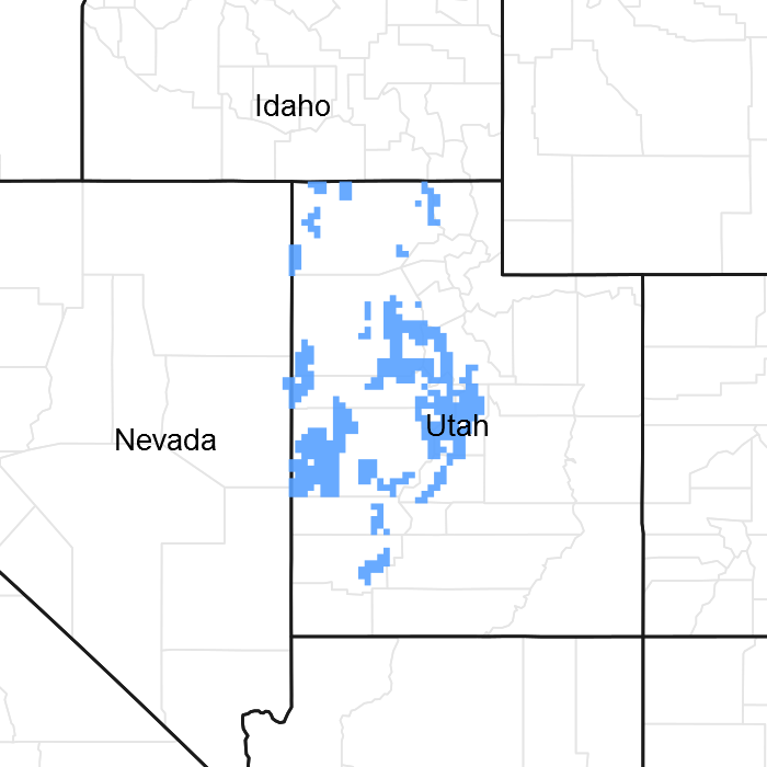
Figure 1. Mapped extent
Areas shown in blue indicate the maximum mapped extent of this ecological site. Other ecological sites likely occur within the highlighted areas. It is also possible for this ecological site to occur outside of highlighted areas if detailed soil survey has not been completed or recently updated.
MLRA notes
Major Land Resource Area (MLRA): 028A–Ancient Lake Bonneville
MLRA 28A occurs in Utah (82 percent), Nevada (16 percent), and Idaho (2 percent). It encompasses approximately 36,775 square miles (95,246 square kilometers). A large area west and southwest of Great Salt Lake is a salty playa. This area is the farthest eastern extent of the Great Basin Section of the Basin and Range Province of the Intermontane Plateaus. It is an area of nearly level basins between widely separated mountain ranges trending north to south. The basins are bordered by long, gently sloping alluvial fans. The mountains are uplifted fault blocks with steep side slopes. Most of the valleys are closed basins containing sinks or playa lakes. Elevation ranges from 3,950 to 6,560 feet (1,204 to 2000 meters) in the basins and from 6,560 to 11,150 feet (1996 to 3398 meters) in the mountains. Much of the MLRA has alluvial valley fill and playa lakebed deposits at the surface from pluvial Lake Bonneville, which dominated this MLRA 13,000 years ago. A level line of remnant lake terraces on some mountain slopes indicates the former extent of this glacial lake. The Great Salt Lake is what remains of the pluvial lake.
Mountains in the interior of this MLRA consist of tilted blocks of marine sediments from Cambrian to Mississippian age with scattered outcrops of Tertiary continental sediments and volcanic rocks. The average annual precipitation is 5 to 12 inches (13 to 30 cm) in the valleys and ranges up to 49 inches (124 cm) in the mountains. Most of the rainfall in the southern LRU occurs as high-intensity, convective thunderstorms during the growing season (April through September). The driest period is from midsummer to early autumn in the northern LRU. Precipitation in winter typically occurs as snow. The average annual temperature is 39 to 53 °F (4 to 12 °C). The freeze-free period averages 165 days and ranges from 110 to 215 days, decreasing in length with increasing elevation. The dominant soil orders in this MLRA are Aridisols, Entisols, and Mollisols. Soils are dominantly in the mesic or frigid soil temperature regime, aridic or xeric soil moisture regime, and mixed mineralogy. The soils are generally well drained, loamy or loamy-skeletal, and very deep.
LRU notes
The Basin and Range North LRU exhibits dry summer with stronger xeric patterns than the Basin and Range South LRU. Ranges in the north LRU are about 50 percent Paleozoic sedimentary/metasedimentary (limestone/quartzite dominant) and about 10 percent Tertiary volcanics. The basin floors are between 4,200 and 5,100 feet (1280 to 1554 meters) in elevation. Pinyon and juniper sites have a greater percentage of Utah juniper (Juniperus osteosperma) in the plant community than pinyon pine (Pinus edulis or monophylla). The Basin and Range North have few semidesert ecological sites with Utah juniper. Cool season grasses, such as bluebunch wheatgrass (Pseudoroegneria spicata), are dominant in the plant community, while warm season grasses are largely absent or a small component of the plant community.
Ecological site concept
The Upland Shallow Loam (Utah Juniper - Singleleaf Pinyon) site is located on mountainsides, hillsides and mountain slopes on steep slopes (30 to 70 percent) between 5,200 and 8,100 feet (1,585 to 2,469 meters). The soil is shallow to a lithic bedrock layer. The soil was formed in colluvium and/or residuum derived from limestone or quartzite and igneous rocks. The surface texture is very cobbly loam with up to 50 percent cover of rocks on the soil surface. The rock volume in the soil profile is about 60 percent. The precipitation ranges from 11 to 24 inches (279 to 609 mm). The dominant vegetation is scattered singleleaf pinyon pine and Utah juniper with an understory of black sagebrush (Artemisia nova) and bluebunch wheatgrass (Pseudoroegneria spicata). The plant composition by air-dry weight is about 50 percent grasses, 5 percent forbs, 30 percent shrubs, and 15 percent trees.
Associated sites
| R028AY418UT |
Mountain Loam (Bigtooth Maple) This site can occur in concave positions higher in elevation. |
|---|---|
| R028AY338UT |
Upland Stony Loam (Pinyon-Utah Juniper) This site will occur in deeper, rocky soils. |
| R028AY456UT |
Mountain Stony Loam (Antelope Bitterbrush) This site will be located upslope or in a moasic in deeper soils. |
| R028AY460UT |
Mountain Shallow Loam (Curl-leaf mountain mahogany) This site will occur in a moasic and on ridges adjacent to 324. |
Similar sites
| R028AY325UT |
Upland Shallow Loam (Black Sagebrush) This site is dominated by black sagebrush. |
|---|---|
| R028AY338UT |
Upland Stony Loam (Pinyon-Utah Juniper) The soil has more rock fragments in the soil profile which effects the production of the site and can be found on steeper slopes. |
| R028AY320UT |
Upland Shallow Hardpan (Pinyon-Utah Juniper) This site occurs on upper fan remnants and has a shallow petrocalcic contact and not a shallow lithic contact. |
| F028AY074NV |
PIMO JUOS/ARNO4/PSSP-ACHY This site is similar to R028AA324UT but was developed in Nevada. |
| R028AB324UT |
Upland Shallow Loam (Singleleaf pinyon-Utah juniper) South This is a similar site that occurs in the Basin and Range South LRU. It typically receives more summer precipitation and has more warm season plants in the community. |
Table 1. Dominant plant species
| Tree |
(1) Juniperus osteosperma |
|---|---|
| Shrub |
(1) Artemisia nova |
| Herbaceous |
(1) Pseudoroegneria spicata |
Physiographic features
The Upland Shallow Loam (Utah Juniper - Singleleaf Pinyon) site occurs on mountainsides, hillsides, and mountain slopes. This site is found on all aspects at elevations between 5,200 and 8,100 feet (1,585 to 2,469 meters). Slopes are steep (30 to 70 percent).
Figure 2.
Figure 3.
Table 2. Representative physiographic features
| Landforms |
(1)
Hillside or mountainside
(2) Mountain slope |
|---|---|
| Flooding frequency | None |
| Ponding frequency | None |
| Elevation | 5,200 – 8,100 ft |
| Slope | 30 – 70% |
| Aspect | Aspect is not a significant factor |
Climatic features
The climate is characterized by warm, dry summers, cold, snowy winters and moist springs. The average annual precipitation is between 11 and 24 inches. October through May is the wettest part of the year and June through August are the driest. The effective moisture for plant growth is the 56 percent that falls during the plant dormant period, which wets the soil deeply in the spring.
Table 3. Representative climatic features
| Frost-free period (characteristic range) | |
|---|---|
| Freeze-free period (characteristic range) | |
| Precipitation total (characteristic range) | 11-24 in |
| Frost-free period (average) | |
| Freeze-free period (average) | |
| Precipitation total (average) | 18 in |
Figure 4. Monthly precipitation range
Figure 5. Monthly average minimum and maximum temperature
Influencing water features
Water Erosion Hazard: Severe to Very Severe
Due to its landscape position, the Upland Shallow Loam (Utah Juniper - Singleleaf Pinyon) site is not typically influenced by streams or wetlands. It can sometimes be influenced by overland flow during heavy thunder storms and/or during wetter spring runoff periods.
Soil features
The soils are shallow over bedrock between 10 and 20 inches of the soil surface. They formed in colluvium and/or residuum derived limestone or quartzite and igneous rocks. The surface horizon has very cobbly loam textures and about 4 inches (10 cm) thick. Up to 48 percent of the soil surface is covered by rock fragments. The volume of rock fragments in the soil profile is 6 to 67 percent. Permeability is moderate. The soil moisture regime is xeric and the soil temperature regime is mesic.
Soil Map Units that may contain this site: Soil Survey Area: Soil Components (Map units in parentheses)
Box Elder County, Utah, Western Part (UT601): Lodar (48, 77, 85); Lundy (84); Solak (84)
Box Elder County, Utah, Eastern Part (UT602): Pass Canyon (POE); Richmond (RMG2); Wheelon variant
Fairfield-Nephi area (UT608): Amtoft (AdE, AdF); Atepic (AmE); Lundy (CcF, LeF); Stepmount (8018)
Tooele Area, Utah – Tooele County and Parts of Box Elder, Davis and Juab Counties (UT611): Lodar (38); Reywat (48)
West Millard-Juab Area, Utah, Parts of Millard and Juab Counties (UT617): Atepic (5, 6); Bentaxle (12, 13); Lodar (12, 85, 86, 87, 104); Sonlet (6)
Sanpete Valley Area, Utah – Parts of Utah and Sanpete Counties (UT627): Atepic (5, ASE2, ATF, AV, MGD); Borvant (FSD2); Lodar (BUD2, LRE, LSG, LTE, LTG)
Beaver County Area (UT628): Atepic (109); Bodacious (110, 111, 112, 178); Lodar (166); Lorhunt (111); Pass Canyon (110, 111, 112, 157, 177, 178, 189); Reebok (177)
Table 4. Representative soil features
| Parent material |
(1)
Colluvium
–
cherty limestone
(2) Residuum – quartzite |
|---|---|
| Surface texture |
(1) Very cobbly loam |
| Drainage class | Well drained to somewhat excessively drained |
| Permeability class | Slow to moderate |
| Soil depth | 10 – 20 in |
| Surface fragment cover <=3" | 5 – 41% |
| Surface fragment cover >3" | 6 – 24% |
| Available water capacity (0-40in) |
1 – 2.5 in |
| Calcium carbonate equivalent (0-40in) |
40% |
| Electrical conductivity (0-40in) |
2 mmhos/cm |
| Sodium adsorption ratio (0-40in) |
2 |
| Soil reaction (1:1 water) (0-40in) |
6.6 – 8.4 |
| Subsurface fragment volume <=3" (Depth not specified) |
18 – 35% |
| Subsurface fragment volume >3" (Depth not specified) |
8 – 24% |
Ecological dynamics
The Upland Shallow Loam (Utah Juniper - Singleleaf Pinyon) site is found in the Great Salt Lake Area of the Basin and Range Ecological Provence. It developed under the natural ecological conditions found there, including the normal influences of native wildlife herbivory, fire and climate. Species composition is generally dominated by an overstory canopy of Utah juniper and singleleaf pinyon. Black sagebrush dominates the shrub layer. A mix of other shrubs including smooth horsebrush, alderleaf mountain mahogany and antelope bitterbrush commonly occur. Perennial herbaceous species occurrence and production is directly related to overstory canopy density with bluebunch wheatgrass, Nevada bluegrass, and Indian ricegrass found most often.
Evidence indicates that this site historically maintained a fairly long burn cycle (100 years or more). Very old singleleaf pinyon and Utah juniper are common on most undisturbed sites. Over time, without fire, tree and shrub canopies increase in density, slowly reducing understory herbaceous vegetation. Following stand removing fire, perennial grasses and forbs flourish for a time, but without fire are again reduced.
Severe drought and insect damage can affect singleleaf pinyon in some locations, causing them to die out, often allowing Utah juniper to further increase. This event can also allow for an increase in shrubs and herbaceous species during periods when wetter years return.
Because of the sites steep slopes, stony, shallow soils and droughty aspect, it is rarely chained and or seeded to introduced forage species. Cheatgrass and annual forbs are most likely to invade this site.
As vegetative communities respond to changes caused by natural or human caused events that cause them to cross ecological thresholds, a return to previous states may not be possible. The amount of effort needed to affect desired vegetative shifts depends on a sites present biotic and abiotic features and the desired results.
The following State and Transition diagram depicts the most common plant communities found on this ecological site. It does not necessarily depict all the plant communities that can occur, but does show the most prevalent and repeatable. As more data are collected, some of these plant communities may be revised or removed, and new ones added. These descriptions capture the current knowledge and experience at the time of this revision.
State and transition model

More interactive model formats are also available.
View Interactive Models
More interactive model formats are also available.
View Interactive Models
Click on state and transition labels to scroll to the respective text
Ecosystem states
State 2 submodel, plant communities
State 3 submodel, plant communities
State 4 submodel, plant communities
State 1
Reference State
The Reference State describes the various biotic communities that are expected to be found on this ecological site under natural conditions. The Reference State has an overstory canopy of Utah juniper with lesser amounts of singleleaf and/or two-needle pinyon. The shrub layer is typically dominated by black sagebrush. A mixture of other shrubs including big sagebrush, antelope bitterbrush, and alderleaf mountain mahogany are commonly found. Bluebunch wheatgrass is the dominant herbaceous species with Nevada bluegrass and Indian ricegrass commonly occurring. Other native grasses, forbs, and shrubs will often produce a significant portion of vegetative composition in the plant community. The Reference State is self-sustaining and resistant to change due to a good natural resilience to its natural disturbances. The primary natural disturbance mechanisms are wildlife population densities which can affect the shrub layer composition, weather fluctuations, and fire period. Definitions: Reference State: Natural plant communities as influenced by tree and shrub canopy densities, long term weather fluctuations, and periodic fire. Indicators: These communities are dominated by Utah juniper, black sagebrush, and bluebunch wheatgrass. The density of the tree and shrub canopies determines the amount and composition of the other native species present in the community. The composition by air-dry weight is approximately 15 percent trees, 35 percent perennial grasses, 10 percent forbs, and 40 percent shrubs. Feedbacks: Natural fluctuations in weather patterns that allow for a self-sustaining tree, shrub and native grass community. Prolonged drought, an increase in fire frequency, or other disturbances may allow for the establishment of invasive species. At-risk Community Phase: All communities are at risk when native plants are stressed and conditions are created that may allow invasive plants to establish. Trigger: The establishment of invasive plant species.
Characteristics and indicators. This state will have only native species in the plant communities.
Community 1.1
Old growth Utah Juniper/Black Sagebrush/Bluebunch Wheatgrass
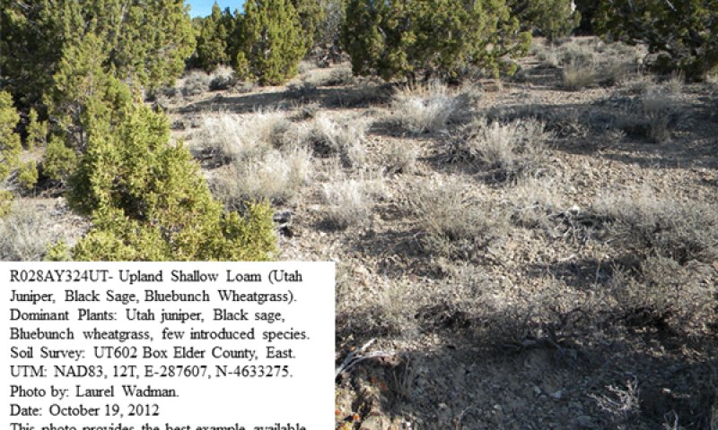
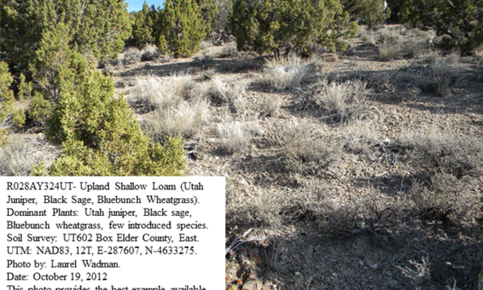
Figure 6. Community Phase 1.1
This community phase is characterized by an open canopy of old Utah juniper and singleleaf or two-needle pinyon. Black sagebrush, Wyoming big sagebrush, antelope bitterbrush, and alderleaf mountain mahogany are common understory shrubs. Commonly occurring grasses and grasslikes include bluebunch wheatgrass, Nevada bluegrass, and Indian ricegrass. Other perennial grasses, shrubs, and forbs are also often present. Air dry composition of this site is approximately 50 percent grasses, 5 percent forbs, 30 percent shrubs, and 15 percent trees. Bare ground is variable (2 to 50 percent) depending on biological crust cover, which is also variable (1 to 25 percent) and surface rock fragments (10 to 70 percent). Biological crusts can vary from sites dominated by light cyanobacteria in the plant interspaces, with occasional moss and lichen pinnacles under shrub canopies, to those dominated by lichen and moss pinnacles as well as cyanobacteria in the site interspaces.
Figure 7. Annual production by plant type (representative values) or group (midpoint values)
Table 5. Annual production by plant type
| Plant type | Low (lb/acre) |
Representative value (lb/acre) |
High (lb/acre) |
|---|---|---|---|
| Grass/Grasslike | 75 | 200 | 325 |
| Shrub/Vine | 85 | 125 | 225 |
| Tree | 75 | 125 | 175 |
| Forb | 20 | 50 | 125 |
| Total | 255 | 500 | 850 |
Table 6. Ground cover
| Tree foliar cover | 10-20% |
|---|---|
| Shrub/vine/liana foliar cover | 15-40% |
| Grass/grasslike foliar cover | 10-30% |
| Forb foliar cover | 3-5% |
| Non-vascular plants | 0% |
| Biological crusts | 0% |
| Litter | 0% |
| Surface fragments >0.25" and <=3" | 0% |
| Surface fragments >3" | 0% |
| Bedrock | 0% |
| Water | 0% |
| Bare ground | 0% |
Table 7. Canopy structure (% cover)
| Height Above Ground (ft) | Tree | Shrub/Vine | Grass/ Grasslike |
Forb |
|---|---|---|---|---|
| <0.5 | – | – | – | – |
| >0.5 <= 1 | – | – | – | – |
| >1 <= 2 | – | 35-45% | 25-35% | 0-10% |
| >2 <= 4.5 | – | – | – | – |
| >4.5 <= 13 | 15-25% | – | – | – |
| >13 <= 40 | – | – | – | – |
| >40 <= 80 | – | – | – | – |
| >80 <= 120 | – | – | – | – |
| >120 | – | – | – | – |
Community 1.2
Bluebunch wheatgrass/pinyon and juniper seedlings/shrubs
This community phase is characterized by a post-fire shrub and herbaceous community. Bluebunch wheatgrass and other perennial grasses dominate. Forbs may increase post-fire but will likely return to pre-burn levels within a few years. Singleleaf pinyon and Utah juniper seedlings up to 20 inches in height may be present. Mountain big sagebrush may be present in unburned patches. Burned tree skeletons may be present; however, these have little or no effect on the understory vegetation.
Community 1.3
Young pinyon and juniper/perennial bunchgrasses/shrubs
This community phase is characterized as an immature woodland with pinyon, juniper trees averaging over 4 feet in height. Pinyon and juniper canopy cover is between 10 to 20 percent. Tree crowns are typically cone- or pyramidal-shaped. Understory vegetation consists of smaller tree seedling and saplings, as well as perennial bunchgrasses and sagebrush.
Community 1.4
Closed Canopy - Utah Juniper/Black Sagebrush Community Phase (at-risk)
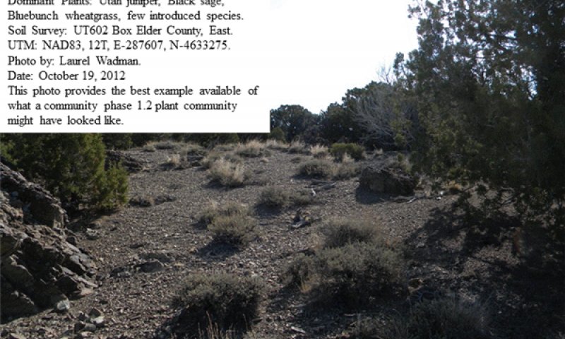
Figure 8. Community Phase 1.4
This community phase is characterized by a closed canopy of Utah juniper and singleleaf or two-needle pinyon. Black sagebrush, Wyoming big sagebrush, antelope bitterbrush, and alderleaf mountain mahogany are common understory shrubs. Bluebunch wheatgrass, Nevada bluegrass and Indian ricegrass are present in the herbaceous layer but are somewhat reduced. Other perennial grasses, shrubs, and forbs may also be present. Air dry composition of this site is approximately 20 percent grasses, 5 percent forbs, 40 percent shrubs, and 35 percent trees. Bare ground is variable (2 to 50 percent) depending on biological crust cover, which is also variable (1 to 25 percent) and surface rock fragments (10 to 70 percent). Biological crusts can vary from sites dominated by light cyanobacteria in the plant interspaces, with occasional moss and lichen pinnacles under shrub canopies, to those dominated by lichen and moss pinnacles as well as cyanobacteria in the site interspaces. This community is at risk of crossing a threshold; without proper management this phase will transition to the Infilled Woodland State 3. This community phase is typically described as early Phase II woodland (Miller et al. 2008).
Table 8. Ground cover
| Tree foliar cover | 10-20% |
|---|---|
| Shrub/vine/liana foliar cover | 15-40% |
| Grass/grasslike foliar cover | 10-30% |
| Forb foliar cover | 3-5% |
| Non-vascular plants | 0% |
| Biological crusts | 0% |
| Litter | 0% |
| Surface fragments >0.25" and <=3" | 0% |
| Surface fragments >3" | 0% |
| Bedrock | 0% |
| Water | 0% |
| Bare ground | 0% |
Table 9. Canopy structure (% cover)
| Height Above Ground (ft) | Tree | Shrub/Vine | Grass/ Grasslike |
Forb |
|---|---|---|---|---|
| <0.5 | – | – | – | – |
| >0.5 <= 1 | – | – | – | – |
| >1 <= 2 | – | 35-45% | 25-35% | 0-10% |
| >2 <= 4.5 | – | – | – | – |
| >4.5 <= 13 | 15-25% | – | – | – |
| >13 <= 40 | – | – | – | – |
| >40 <= 80 | – | – | – | – |
| >80 <= 120 | – | – | – | – |
| >120 | – | – | – | – |
Pathway 1.1a
Community 1.1 to 1.2
A high severity crown fire will eliminate or reduce the singleleaf pinyon and Utah juniper overstory and the shrub component. This allows the perennial bunchgrasses to increase.
Pathway 1.1b
Community 1.1 to 1.4
This community pathway occurs when long-term drought and/or extended periods without fire allows canopies of Utah juniper and singleleaf pinyon to significantly increase. This closing canopy event causes understory vegetation to be reduced and eventually nearly eliminated from the site. Drought alone can also reduce native perennial grass production and eventually eliminate some species from the system. Improper livestock grazing during these periods can facilitate this process.
Pathway 1.2a
Community 1.2 to 1.3
Time without disturbance such as fire, long-term drought, or disease will allow for the gradual maturation of the singleleaf pinyon and Utah Juniper component. Black and big sagebrush reestablishes. Excessive herbivory may also reduce perennial grass understory.
Pathway 1.3a
Community 1.3 to 1.2
Time without disturbance such as fire, long-term drought, or disease will allow for the gradual maturation of singleleaf pinyon and Utah juniper. Infilling by younger trees continues.
Pathway 1.3b
Community 1.3 to 1.4
Fire reduces or eliminates tree canopy, allowing perennial grasses to dominate the site.
Pathway 1.4a
Community 1.4 to 1.1
This community pathway occurs when weather patterns return to within normal ranges and some level of fire reduces Utah juniper and singleleaf pinyon, significantly opening the sites canopy. Insect damage on singleleaf pinyon can also cause its canopy to be reduced on this site. This more open canopy allows understory vegetation to recover and increase in production, and under some circumstances, flourish on the site. Proper livestock grazing during these periods can facilitate this process.
Pathway 1.4b
Community 1.4 to 1.2
A high-severity crown fire will eliminate or reduce the singleleaf pinyon and Utah juniper overstory and the shrub component which will allow for the perennial bunchgrasses to dominate the site.
State 2
Current Potential State
The Current Potential State is similar to the Reference Sate except that non-native species are now present. Ecological function has not changed; however the resiliency of the state has been reduced by the presence of non-native species. These non-natives, particularly cheatgrass, can be highly flammable and promote fire where historically fire had been infrequent. Negative feedbacks enhance ecosystem resilience and contribute to the stability of the state. These include the presence of all structural and functional groups, low fine fuel loads and retention of organic matter and nutrients. Positive feedbacks decrease ecosystem resilience and stability of the state. These include the nonnatives’ high seed output, persistent seed bank, rapid growth rate, ability to cross pollinate, and adaptations for seed dispersal. Fires within this community with the small amount of non-native annual species present are likely still small and patchy due to low fuel loads. This fire type will create a plant community mosaic that will include all/most of the following community phases within this state. The Current Potential State describes the plant communities that may or have become established on this ecological site under various successional sequences and disturbance conditions. This state typically has a well developed overstory canopy composed of Utah juniper with lesser amounts of singleleaf and/or two-needle pinyon. Black sagebrush often dominates the shrub layer. Wyoming big sagebrush, antelope bitterbrush, and alderleaf mountain mahogany are common shrub species. Bluebunch wheatgrass is the dominant herbaceous species with Indian ricegrass, Nevada bluegrass and other perennial grasses and forbs also commonly found in abundance. Cheatgrass, alyssum, various mustard species and other non-native species are present on the site and, under certain circumstances, may visually dominate the sites aspect. The primary disturbance mechanisms are the tree and shrub layer densities; the amount and kinds of invasive species present; weather fluctuations; and fire. The Current Potential State is still self-sustaining but may be losing its resistance to change due to the impact of disturbances with less resilience following those disturbances. Definitions: Current Potential State: Plant communities influenced by tree and shrub canopy density, long term weather fluctuations, and periodic fire. Invasive species are present in various amounts. Indicators: A community dominated by Utah juniper, black sagebrush and bluebunch wheatgrass. The density of the tree and shrub canopies determines the amount and composition of the other native and introduced grasses and forbs that may be present. Feedbacks: Natural fluctuations in weather patterns that allow for a self sustaining shrub and native grass community. Prolonged drought, more frequent fires, and/or other disturbances that may allow for the increase of invasive species. At-risk Community Phase: All communities are at risk when native plants are stressed and nutrients become available for invasive plants to increase. Trigger: A reduction of perennial grass and forb species combined with an increase of invasive plant species.
Characteristics and indicators. This state will have non-native species in the plant community.
Community 2.1
Open Canopy - Utah Juniper/Black Sagebrush/Bluebunch Wheatgrass/Invasive weed
Figure 9. Community Phase 2.1
This community phase is characterized by an open canopy of Utah juniper and singleleaf or two-needle pinyon. Black sagebrush, Wyoming big sagebrush, antelope bitterbrush, and alderleaf mountain mahogany are common understory shrubs. Commonly occurring grasses and grasslikes include cheatgrass, bluebunch wheatgrass, Nevada bluegrass, and Indian ricegrass. Non-native species are now present in the all plant communities and are expected to remain a permanent part of these communities. Air dry composition of this site is approximately 35 percent grasses, 10 percent forbs, 30 percent shrubs, and 25 percent trees. Bare ground is variable (2 to 50 percent) depending on biological crust cover, which is also variable (1 to 25 percent) and surface rock fragments (10 to 70 percent). Biological crusts can vary from sites dominated by light cyanobacteria in the plant interspaces, with occasional moss and lichen pinnacles under shrub canopies, to those dominated by lichen and moss pinnacles as well as cyanobacteria in the site interspaces. Ground fires within this community are infrequent occurring on average every 15 to 25 years. This fire type will create a plant community mosaic that will include all/most of the following community phases within this state. Annual non-native species are present in trace amounts.
Table 10. Ground cover
| Tree foliar cover | 10-20% |
|---|---|
| Shrub/vine/liana foliar cover | 15-40% |
| Grass/grasslike foliar cover | 10-30% |
| Forb foliar cover | 3-5% |
| Non-vascular plants | 0% |
| Biological crusts | 0% |
| Litter | 0% |
| Surface fragments >0.25" and <=3" | 0% |
| Surface fragments >3" | 0% |
| Bedrock | 0% |
| Water | 0% |
| Bare ground | 0% |
Table 11. Canopy structure (% cover)
| Height Above Ground (ft) | Tree | Shrub/Vine | Grass/ Grasslike |
Forb |
|---|---|---|---|---|
| <0.5 | – | – | – | – |
| >0.5 <= 1 | – | – | – | – |
| >1 <= 2 | – | 35-45% | 25-35% | 0-10% |
| >2 <= 4.5 | – | – | – | – |
| >4.5 <= 13 | 15-25% | – | – | – |
| >13 <= 40 | – | – | – | – |
| >40 <= 80 | – | – | – | – |
| >80 <= 120 | – | – | – | – |
| >120 | – | – | – | – |
Community 2.2
Bluebunch wheatgrass/pinyon and juniper seedlings/shrubs
Figure 10. Photo taken by K. Wadman
This community phase is characterized by a post-fire shrub and herbaceous community. Bluebunch wheatgrass and other perennial grasses dominate. Forbs may increase post-fire but will likely return to pre-burn levels within a few years. Pinyon and juniper seedlings up to 20 inches in height may be present. Mountain big sagebrush may be present in unburned patches. Burned tree skeletons may be present; however, these have little or no effect on the understory vegetation. Annual non-native species generally respond well after fire and may be stable or increasing within the community.
Community 2.3
Pinyon and juniper young trees/perennial bunchgrasses/shrubs
This community phase is characterized by an immature woodland, with singleleaf pinyon and Utah juniper trees averaging over 4 feet in height. Tree canopy cover is between 10 to 20 percent. Tree crowns are typically cone- or pyramidal-shaped. Understory vegetation consists of smaller tree seedling and saplings, as well as perennial bunchgrasses and shrubs. Annual nonnative species are present.
Community 2.4
Pinyon and Utah Juniper/perennial bunchgrasses/shrubs

Figure 11. Community Phase 2.2
This community phase is characterized by a canopy of Utah juniper and singleleaf or two-needle pinyon that exceeds 20 percent cover. The density and vigor of the mountain big sagebrush and perennial bunchgrass understory is decreased. Bare ground areas are likely to increase. Mat-forming forbs may increase. Annual non-native species are present primarily under tree canopies. This community is at risk of crossing a threshold, without proper management this phase will transition to the Infilled Tree State 3. This community phase is typically described as early Phase II woodland (Miller et al. 2008). Black sagebrush, Wyoming big sagebrush, antelope bitterbrush, and alderleaf mountain mahogany are common understory shrubs. Cheatgrass, bluebunch wheatgrass, Nevada bluegrass, and Indian ricegrass are present in the herbaceous layer but are much reduced. Non-native species are now present in the all plant communities and are expected to remain a permanent part of these communities. Air dry composition of this site is approximately 20 percent grasses, 10 percent forbs, 30 percent shrubs, and 40 percent trees. Bare ground is variable (2 to 50 percent) depending on biological crust cover, which is also variable (1 to 25 percent) and surface rock fragments (10 to 70 percent). Biological crusts can vary from sites dominated by light cyanobacteria in the plant interspaces, with occasional moss and lichen pinnacles under shrub canopies, to those dominated by lichen and moss pinnacles as well as cyanobacteria in the site interspaces.
Table 12. Ground cover
| Tree foliar cover | 10-20% |
|---|---|
| Shrub/vine/liana foliar cover | 15-40% |
| Grass/grasslike foliar cover | 10-30% |
| Forb foliar cover | 3-5% |
| Non-vascular plants | 0% |
| Biological crusts | 0% |
| Litter | 0% |
| Surface fragments >0.25" and <=3" | 0% |
| Surface fragments >3" | 0% |
| Bedrock | 0% |
| Water | 0% |
| Bare ground | 0% |
Table 13. Canopy structure (% cover)
| Height Above Ground (ft) | Tree | Shrub/Vine | Grass/ Grasslike |
Forb |
|---|---|---|---|---|
| <0.5 | – | – | – | – |
| >0.5 <= 1 | – | – | – | – |
| >1 <= 2 | – | 35-45% | 25-35% | 0-10% |
| >2 <= 4.5 | – | – | – | – |
| >4.5 <= 13 | 15-25% | – | – | – |
| >13 <= 40 | – | – | – | – |
| >40 <= 80 | – | – | – | – |
| >80 <= 120 | – | – | – | – |
| >120 | – | – | – | – |
Pathway 2.1a
Community 2.1 to 2.2
A high-severity crown fire will eliminate or reduce the singleleaf pinyon and Utah juniper overstory and the shrub component. This allows for the perennial bunchgrasses to dominate the site.
Pathway 2.1b
Community 2.1 to 2.4
This community pathway occurs when long-term drought and/or extended periods without fire allows canopies of Utah juniper and singleleaf pinyon to significantly increase. This closed canopy causes understory vegetation to be reduced or nearly eliminated from the site. Drought and/or improper livestock grazing alone, or in combination, can also reduce native perennial grass production, and eventually eliminate them from the system. Non-native annuals may increase during these periods.
Pathway 2.2a
Community 2.2 to 2.3
Time without disturbance such as fire, long-term drought, or disease will allow for the gradual maturation of the singleleaf pinyon and Utah Juniper component. Sagebrush reestablishes. Excessive herbivory may also reduce perennial grass understory.
Pathway 2.3a
Community 2.3 to 2.2
Time without disturbance such as fire, long-term drought, or disease will allow for the gradual maturation of singleleaf pinyon and Utah juniper. Infilling by younger trees continues.
Pathway 2.3b
Community 2.3 to 2.4
Fire reduces or eliminates tree canopy, allowing perennial grasses to dominate the site
Pathway 2.4a
Community 2.4 to 2.1
This community pathway occurs when weather patterns return to within normal ranges and some level of fire reduces Utah juniper and singleleaf pinyon, significantly opening the sites canopy. Insect damage on singleleaf pinyon can also cause it to be reduced on this site. This more open canopy allows understory vegetation to increase and under some circumstances, flourish on the site. Proper livestock grazing during these periods can facilitate this process.
Pathway 2.4b
Community 2.4 to 2.2
A high-severity crown fire will eliminate or reduce the singleleaf pinyon and Utah juniper overstory and the shrub component which will allow for the perennial bunchgrasses to dominate the site. Annual non-native grasses typically respond positively to fire and may increase in the post-fire community.
State 3
Infilled Tree State
The Infilled Tree State has one community phase that is characterized by the dominance of Utah juniper and singleleaf pinyon in the overstory. This state is identifiable by 30 to over 50 percent cover of Utah juniper and singleleaf pinyon. This stand exhibits a mixed age class. Older trees are at maximal height and upper crowns may be flat-topped or rounded. Younger trees are typically cone- or pyramidal shaped. Understory vegetation is sparse due to increasing shade and competition from trees.
Community 3.1
Pinyon and juniper/invasive annuals/native perennials and shrubs
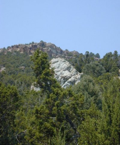
Figure 12. Image taken by USU GAP analysis.
Singleleaf pinyon and Utah juniper dominate the aspect. Understory vegetation is thinning. Perennial bunchgrasses are sparse and sagebrush skeletons are as common as live shrubs due to tree competition for soil water, overstory shading, and duff accumulation. Tree canopy cover is greater than 30 percent. Annual non-native species are present or co-dominate in the understory. Bare ground areas are prevalent. This community phase is typically described as a Phase II woodland (Miller et al. 2008).
State 4
Annual State
The Annual State occurs when a recent crown fire has removed most of the Utah juniper and any pinyon trees present from the site. Black sagebrush and other fire sensitive species have also been removed or significantly reduced. The site has a herbaceous aspect with both native and non-native grass and forb species present. Fire resistant shrubs are typically recovering and are increasing in the communities associated with this state. The herbaceous vegetation communities associated with this state can be highly variable depending on the before fire conditions. Typically however, bluebunch wheatgrass is the dominant herbaceous species with Indian ricegrass, Nevada bluegrass, and other perennial grasses and forbs commonly found. Cheatgrass, alyssum, various mustard species, and other non-native species are often present on the site and, under certain circumstances, may visually dominate the sites aspect. The primary disturbance mechanisms intensity of the fire; the amount and kinds of native and non-native species present; weather fluctuations; and time since the fire occurred. This state may be losing self-sustainability or may be increasing its resistance to degradation due to the impact of fire and the before fire conditions. Definitions: Annual: Plant communities influenced by recent crown fire and its impact on the tree and shrub canopy density, long term weather fluctuations, time since the fire occurred. Invasive species are present in various amounts. Indicators: A community dominated by herbaceous species. The kind and amounts of native and introduced grasses and forbs that may be present. Feedbacks: Natural fluctuations in weather patterns that allow for a self sustaining shrub and native grass community to develop. Prolonged drought, more frequent fires, and/or other disturbances that may allow for the increase of invasive species. At-risk Community Phase: All communities are at risk when native plants are stressed and nutrients become available for invasive plants to increase. Annual grasses and forbs that may shorten the sites fire period. Trigger: A reduction of perennial grass and forb species combined with an increase of invasive plant species.
Community 4.1
Introduced non-native species/native perennials/native shrubs
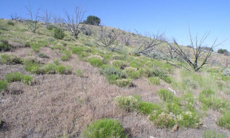
Figure 13. Oak City Watershed. Dominant plants are rabbitbrush and cheatgrass with few native perennials. Photo taken 6/17/2008 by Shane Green, NAD83 N0388039 E4361847
This community phase is created after fire has recently (typically 1 to 5 years) removed most of the Utah juniper and singleleaf or two-needle pinyon from the site. Black sagebrush, Wyoming big sagebrush, antelope bitterbrush, and alderleaf mountain mahogany have also been reduced but may be slowly recovering. Commonly occurring grasses and grasslikes include cheatgrass, bluebunch wheatgrass, Nevada bluegrass, and Indian ricegrass. Non-native species are present in the all plant communities and are expected to remain a permanent part and potentially dominate these communities. Air dry composition of this site is approximately 60 percent grasses, 10 percent forbs, 20 percent shrubs, and 10 percent trees. Bare ground is variable (2 to 50 percent) depending on biological crust cover, which is also variable (1 to 25 percent) and surface rock fragments (10 to 70 percent). Biological crusts can vary from sites dominated by light cyanobacteria in the plant interspaces, with occasional moss and lichen pinnacles under shrub canopies, to those dominated by lichen and moss pinnacles as well as cyanobacteria in the site interspaces.
Table 14. Ground cover
| Tree foliar cover | 10-20% |
|---|---|
| Shrub/vine/liana foliar cover | 15-40% |
| Grass/grasslike foliar cover | 10-30% |
| Forb foliar cover | 3-5% |
| Non-vascular plants | 0% |
| Biological crusts | 0% |
| Litter | 0% |
| Surface fragments >0.25" and <=3" | 0% |
| Surface fragments >3" | 0% |
| Bedrock | 0% |
| Water | 0% |
| Bare ground | 0% |
Table 15. Canopy structure (% cover)
| Height Above Ground (ft) | Tree | Shrub/Vine | Grass/ Grasslike |
Forb |
|---|---|---|---|---|
| <0.5 | – | – | – | – |
| >0.5 <= 1 | – | – | – | – |
| >1 <= 2 | – | 35-45% | 25-35% | 0-10% |
| >2 <= 4.5 | – | – | – | – |
| >4.5 <= 13 | 15-25% | – | – | – |
| >13 <= 40 | – | – | – | – |
| >40 <= 80 | – | – | – | – |
| >80 <= 120 | – | – | – | – |
| >120 | – | – | – | – |
Transition T1A
State 1 to 2
This transitional pathway occurs when any combination of improper livestock grazing, prolonged drought or other disturbance causes the perennial herbaceous community to become significantly reduced allowing non-native species such as cheatgrass, alyssum, Russian thistle and other invasive weeds to become established. Broom snakeweed may also increase during this time. Once invasive species occupy the site, a threshold has been crossed. Cheatgrass, however, has been known to become established in healthy communities on this site. Trigger: Introduction of non-native annual species Slow variables: Over time the annual non-native plants will increase within the community. Threshold: Any amount of introduced non-native species causes an immediate decrease in the resilience of the site. Annual non-native species cannot be easily removed from the system and have the potential to significantly alter disturbance regimes from their historic range of variation.
Transition T1B
State 1 to 3
Trigger: Time and a lack of disturbance allow trees to dominate site resources; may be coupled with inappropriate grazing management that favors shrub and tree dominance. Slow variables: Over time the abundance and size of trees will increase. Threshold: Juniper and pinyon canopy cover is greater than 30 percent. Little understory vegetation remains due to competition with trees for site resources.
Transition T2A
State 2 to 3
Trigger: Catastrophic crown fire facilitates the establishment of non-native, annual weeds. Slow variables: Increase in tree crown cover, loss of perennial understory and an increase in annual non-native species. Threshold: Cheatgrass or other non-native annuals dominate understory. Loss of deep-rooted perennial bunchgrasses changes spatial and temporal nutrient cycling and nutrient redistribution, and reduces soil organic matter. Increased canopy cover of trees allows severe stand-replacing fire. The increased seed bank of non-native, annual species responds positively to post-fire conditions facilitating the transition to an Annual State.
Transition T2B
State 2 to 4
This transitional pathway occurs when a major fire removes nearly all the Utah juniper and any pinyon present from the site. A combination of improper livestock grazing, prolonged drought, or other disturbance can slow the expected recovery of the perennial herbaceous community, allowing non-native species such as cheatgrass, alyssum, Russian thistle, and other invasive weeds to flourish. Broom snakeweed may also increase during this time. Fire tolerant shrubs will often recover quickly during these periods.
Restoration pathway R3A
State 3 to 2
Manual or mechanical thinning of trees coupled with seeding. Probability of success is highest from early on in community phase 3.1 before the understory is depleted.
Transition T3A
State 3 to 4
Trigger: Fire reduces the tree overstory and allows for the annual non-native species in the understory to dominate the site. Soil disturbing treatments such as slash and burn may also reduce tree canopy and allow for non-native annual species to increase. Slow variables: Over time, cover and production of annual non-native species increases. Threshold: Loss of deep-rooted perennial bunchgrasses and shrubs changes temporal and spatial nutrient capture and cycling within the community. Increased, continuous fine fuels modify the fire regime by increasing frequency, size, and spatial variability of fires.
Additional community tables
Table 16. Community 1.1 plant community composition
| Group | Common name | Symbol | Scientific name | Annual production (lb/acre) | Foliar cover (%) | |
|---|---|---|---|---|---|---|
|
Grass/Grasslike
|
||||||
| 1 | Primary Grasses | 125–225 | ||||
| bluebunch wheatgrass | PSSP6 | Pseudoroegneria spicata | 55–120 | – | ||
| Indian ricegrass | ACHY | Achnatherum hymenoides | 15–60 | – | ||
| squirreltail | ELEL5 | Elymus elymoides | 15–60 | – | ||
| 4 | Secondary Grasses | 25–55 | ||||
| Grass, perennial | 2GP | Grass, perennial | 5–20 | – | ||
| blue grama | BOGR2 | Bouteloua gracilis | 1–20 | – | ||
| Geyer's sedge | CAGE2 | Carex geyeri | 1–20 | – | ||
| squirreltail | ELEL5 | Elymus elymoides | 1–20 | – | ||
| needle and thread | HECO26 | Hesperostipa comata | 1–20 | – | ||
| prairie Junegrass | KOMA | Koeleria macrantha | 1–20 | – | ||
| saline wildrye | LESAS | Leymus salinus ssp. salinus | 1–20 | – | ||
| western wheatgrass | PASM | Pascopyrum smithii | 1–20 | – | ||
| James' galleta | PLJA | Pleuraphis jamesii | 1–20 | – | ||
| muttongrass | POFE | Poa fendleriana | 1–20 | – | ||
| Sandberg bluegrass | POSE | Poa secunda | 1–20 | – | ||
| sand dropseed | SPCR | Sporobolus cryptandrus | 1–20 | – | ||
|
Forb
|
||||||
| 2 | Forbs | 35–60 | ||||
| Forb, annual | 2FA | Forb, annual | 7–20 | – | ||
| Forb, perennial | 2FP | Forb, perennial | 7–20 | – | ||
| littleleaf pussytoes | ANMI3 | Antennaria microphylla | 1–20 | – | ||
| Fendler's sandwort | ARFE3 | Arenaria fendleri | 1–20 | – | ||
| freckled milkvetch | ASLE8 | Astragalus lentiginosus | 1–20 | – | ||
| Hooker's balsamroot | BAHO | Balsamorhiza hookeri | 1–20 | – | ||
| Wyoming Indian paintbrush | CALI4 | Castilleja linariifolia | 1–20 | – | ||
| sego lily | CANU3 | Calochortus nuttallii | 1–20 | – | ||
| Douglas' dustymaiden | CHDO | Chaenactis douglasii | 1–20 | – | ||
| maiden blue eyed Mary | COPA3 | Collinsia parviflora | 1–20 | – | ||
| tapertip hawksbeard | CRAC2 | Crepis acuminata | 1–20 | – | ||
| roundspike cryptantha | CRHU2 | Cryptantha humilis | 1–20 | – | ||
| cushion buckwheat | EROV | Eriogonum ovalifolium | 1–20 | – | ||
| shaggy fleabane | ERPU2 | Erigeron pumilus | 1–20 | – | ||
| ballhead ipomopsis | IPCOC3 | Ipomopsis congesta ssp. congesta | 1–20 | – | ||
| Bonneville pea | LABR | Lathyrus brachycalyx | 1–20 | – | ||
| hoary tansyaster | MACA2 | Machaeranthera canescens | 1–20 | – | ||
| low beardtongue | PEHU | Penstemon humilis | 1–20 | – | ||
| rock goldenrod | PEPU7 | Petradoria pumila | 1–20 | – | ||
| spiny phlox | PHHO | Phlox hoodii | 1–20 | – | ||
| longleaf phlox | PHLO2 | Phlox longifolia | 1–20 | – | ||
| gooseberryleaf globemallow | SPGR2 | Sphaeralcea grossulariifolia | 1–20 | – | ||
| Pacific aster | SYCHC | Symphyotrichum chilense var. chilense | 1–20 | – | ||
|
Shrub/Vine
|
||||||
| 3 | Primary Shrubs | 70–150 | ||||
| black sagebrush | ARNO4 | Artemisia nova | 45–150 | – | ||
| alderleaf mountain mahogany | CEMO2 | Cercocarpus montanus | 10–60 | – | ||
| antelope bitterbrush | PUTR2 | Purshia tridentata | 10–60 | – | ||
| 5 | Secondary Shrubs | 20–40 | ||||
| Shrub (>.5m) | 2SHRUB | Shrub (>.5m) | 0–30 | – | ||
| Utah serviceberry | AMUT | Amelanchier utahensis | 0–30 | – | ||
| desert ceanothus | CEGR | Ceanothus greggii | 0–30 | – | ||
| littleleaf mountain mahogany | CEIN7 | Cercocarpus intricatus | 0–30 | – | ||
| curl-leaf mountain mahogany | CELE3 | Cercocarpus ledifolius | 0–30 | – | ||
| yellow rabbitbrush | CHVI8 | Chrysothamnus viscidiflorus | 0–30 | – | ||
| Nevada jointfir | EPNE | Ephedra nevadensis | 0–30 | – | ||
| slender buckwheat | ERMI4 | Eriogonum microthecum | 0–30 | – | ||
| broom snakeweed | GUSA2 | Gutierrezia sarothrae | 0–30 | – | ||
| plains pricklypear | OPPO | Opuntia polyacantha | 0–30 | – | ||
| Mexican cliffrose | PUME | Purshia mexicana | 0–30 | – | ||
| mountain snowberry | SYOR2 | Symphoricarpos oreophilus | 0–30 | – | ||
|
Tree
|
||||||
| 6 | Trees | 100–160 | ||||
| Utah juniper | JUOS | Juniperus osteosperma | 50–120 | – | ||
| twoneedle pinyon | PIED | Pinus edulis | 20–50 | – | ||
| singleleaf pinyon | PIMO | Pinus monophylla | 20–50 | – | ||
Interpretations
Animal community
--Wildlife Interpretation--
The Upland Shallow Loam (Utah Juniper - Singleleaf Pinyon) ecological site, in Reference State, produces significant amounts of nutritious forage that was utilized by native herbivores including Rocky Mountain elk, mule deer, and pronghorn antelope who lived here along with their associated predators. Although much of this site is presently different from the reference state, it is still very important as wildlife habitat. Other wildlife commonly observed using this site include mountain lions, rabbits, coyotes, badgers, and red fox's.
This site also provides habitat to raptors and other bird species including golden eagles, red-tailed hawks, ferruginous hawks, and several species of owls. Ringneck pheasant, sage grouse, chukars, and California quail are also commonly found.
--Grazing Interpretations--
The Upland Shallow Loam (Utah Juniper - Singleleaf Pinyon) site provides good spring, fall, and winter grazing conditions for domestic livestock due to its accessibility and its supply of nutritious forage. The herbaceous plant community is primarily grasses, with the majority of canopy cover being attributed to bluebunch wheatgrass and Nevada bluegrass. Improper livestock grazing can cause these species to decrease while annual forbs, black sagebrush and rabbitbrush species increase.
When this site is stressed, cheatgrass, alyssum, Russian thistle, and Halogeton are likely to invade.
Hydrological functions
The soils associated with this ecological site are generally in Hydrologic Soil Group D due to the shallow depth (NRCS National Engineering Handbook). Runoff curves range from 80 to 89. These soils are saturated quickly due to high infiltration rates and shallow depth; once soils are saturated, run off potential is high. Hydrological groups are used in equations that estimate runoff from rainfall. These estimates are needed for solving hydrologic problems that arise in planning watershed-protection and flood-prevention projects and for designing structures for the use, control and disposal of water. Heavy grazing can alter the hydrology by decreasing plant cover and increasing bare ground. Fire can also affect hydrology, but its affect is variable. Fire intensity, fuel type, soil, climate, and topography can each have different influences. Fires can increase areas of bare ground and hydrophobic layers that reduce infiltration and increase runoff (National Range and Pasture Handbook, 2003).
Recreational uses
Recreation activities include aesthetic value and good opportunities for hiking, horseback riding, hunting, and off-road vehicle use. Due to the high erosion potential after a surface disturbance, care should be taken when planning recreational activities. Camp sites are usually limited due to lack of sheltering trees or rock outcrop.
Wood products
Utah juniper and singleleaf and/or two-needle pinyon can provide firewood and fence post where growth is sufficient and regulations allow for such use. The pinyon trees are a good source of pine-nuts.
Other products
None.
Other information
--Poisonous and Toxic Plant Communities--
Toxic plants associated with this site include woolly locoweed, broom snakeweed, and Russian thistle.
Woolly locoweed is toxic to all classes of livestock and wildlife. Locoweed is palatable and has similar nutrient value to alfalfa, which may cause animals to consume it even when other forage is available. Locoweed contains swainsonine (indolizdine alkaloid) and is poisonous at all stages of growth. Poisoning will become evident after 2-3 weeks of continuous grazing and is associated with 4 major symptoms: 1) neurological damage, 2) emaciation, 3) reproductive failure and abortion, and 4) congestive heart failure linked with “high mountain disease”.
Broom snakeweed contains steroids, terpenoids, saponins, and flavones that can cause abortions or reproductive failure in sheep and cattle, however, cattle are most susceptible. These toxins are most abundant during active growth and leafing stage. Cattle and sheep generally will only graze broom snakeweed when other forage is unavailable, typically in winter when toxicity levels are at their lowest (Knight and Walter, 2001).
Russian thistle is an invasive toxic plant, causing nitrate and to a lesser extent oxalate poisoning, which affects all classes of livestock. The buildup of nitrates in these plants is highly dependent upon environmental factors such as after a rain storm, during a drought, during periods with cool/cloudy days, and when growing on soils high in nitrogen and low in sulfur and phosphorus. Nitrate collects in the stems and can persist throughout the growing season. Clinical signs of nitrate poisoning include drowsiness, weakness, muscular tremors, increased heart and respiratory rates, staggering gait, and death. Conversely, oxalate poisoning causes kidney failure; clinical signs include muscle tremors, tetany, weakness, and depression. Poisoning generally occurs when livestock consume and are not accustomed to grazing oxalate-containing plants. Animals with prior exposure to oxalates have increased numbers of oxalate-degrading rumen microflora, and thus, are able to degrade the toxin before clinical poisoning can occur.
--Invasive Plant Communities--
Generally, as ecological conditions deteriorate and perennial vegetation decreases due to disturbance (fire, drought, off road vehicle overuse, erosion, etc.) annual forbs and grasses may invade the site. Of particular concern in semi-arid environments are annual invaders including cheatgrass, Russian thistle, alyssum and annual mustards. The presence of these species will depend on soil properties and moisture availability; however, these invaders are highly adaptive and can flourish in many locations. Once established, complete removal is difficult, but suppression may be possible.
On well developed Utah juniper and singleleaf pinyon communities, soils are often completely occupied by lateral roots which can inhibit the herbaceous understory as well as limit annual invasive species. Once these sites are disturbed and pinyon-juniper communities begin to decline, their increase or invasion is possible.
--Fire Ecology--
The ability for an ecological site to carry fire depends primarily on its' present fuel load and plant moisture content. Sites with small fuel loads will burn more slowly and less intensely than sites with large fuel loads. The Utah juniper and singleleaf and/or two-needle pinyon communities growing on shallow soils are quite unique. These trees can support stand-replacing fires, though historically, fires were likely a mixture of surface and crown fires with intensities and frequencies dependent on site productivity. Most research agrees that historic fire return intervals are at a minimum 100 years, indicating that fire may have not played an important role in short term community dynamics. Fires are more common when trees are stressed or dead due to drought and/or beetle infestations. Pinyon-juniper stands reestablish either by seeds dispersed from adjacent unburned patches or by unburned seeds found at the burn site. Continuous (every 20-40 years) burning of these ecological sites can result in shrub dominated communities, due to the relatively fast recovery of shrubs when compared to trees. If invasive annual grasses are allowed to establish, fires may become more frequent, inhibiting the site’s ability to recover.
Supporting information
Type locality
| Location 1: Juab County, UT | |
|---|---|
| Township/Range/Section | T15S R2W S36 |
| General legal description | Map 87, P-6, PF14-4 Warm Springs Soil Survey, Needle Range- Beaver, Co. SE ¼ of the SW ¼, Section 36, Township 15S, Range 2W |
Other references
Anderson, E. W. and R. J. Scherzinger. 1975. Improving quality of winter forage for elk by cattle grazing. Journal of Range Management:120-125.
Baily, R.G. 1995. Description of the ecoregions of the United Sates. Available http://www.fs.fed.us/land/ecosysmgmt/ecoreg1_home.html. Accessed February 27, 2008.
Belnap, J. and S.L. Phillips. 2001. Soil biota in an ungrazed grassland: response to annual grass (Bromus tectorum) invasion. Ecological Applications. 11:1261-1275
Blaisdell, J.P. and J.F. Pechanec. 1949. Effects of herbage removal at various dates on vigor of bluebunch wheatgrass and arrowleaf balsamroot. Ecology 30(3):298-305.
Chapin, S.F., B.H. Walker, R.J. Hobbs, D.U. Hooper, J.H. Lawton, O.E. Sala, and D. Tilman. 1997. Biotic control over the functioning of ecosystems. Science. 277:500-504
Cox R.D. and V.J. Anderson. 2004. Increasing native diversity of cheatgrass-dominated rangeland through assisted succession. Journal of Range Management. 57:203-210,
Daubenmire, R. 1970. Steppe Vegetation of Washington. 131 pp.
Gruell, G.E. 1999. Historical and modern roles of fire in pinyon-juniper. In: S. B. Monsen, R. Stevens [comps.] Proceedings: ecology and management of pinyon–juniper communities within the Interior West. RMRS-P-9. Ogden, UT, USA: US Department of Agriculture, Forest Service, Rocky Mountain Research Station. p. 24-28.
Howard, Janet L. 2003. Atriplex canescens. In: Fire Effects Information System. U.S. Department of Agriculture, Forest Service, Rocky Mountain Research Station, Fire Sciences Laboratory (Producer). Available: http://www.fs.fed.us/database/feis/. Accessed on February 25, 2008.
Jameson, D.A. 1970. Degradation and accumulation on inhibitory substances from Juniperus osteosperma (Torr.) Little. Plant Soil 33: 213-224.
Knight, A.P. and R.G. Walter. 2001. A guide to plant poisoning of animals in North America. Teton NewMedia. Jackson, WY.
Laycock, W. A. 1967. How heavy grazing and protection affect sagebrush-grass ranges. Journal of Range Management:206-213.
Lett, M. S., and A. K. Knapp. 2005. Woody plant encroachment and removal in mesic grassland: Production and composition responses of herbaceous vegetation. American Midland Naturalist 153:217-231.
Miller, R.F., J.C. Chambers, D.A. Pyke, F.B. Pierson, and C.J. Williams. 2013. A review of fire effects on vegetation and soils in the Great Basin Region: response and ecological site characteristics. Gen. Tech. Rep. RMRS-GTR-308. Fort Collins, CO: U.S. Department of Agriculture, Forest Service, Rocky Mountain Research Station. 126 p.
Miller, R. F., T. J. Svejcar, and J. A. Rose. 2000. Impacts of western juniper on plant community composition and structure. Journal of Range Management:574-585.
Miller, R.F. R.J. Tasuch, E.D. McArthur, D.D. Johnson and S.C. Sanderson. 2008. Age Structure and Expansion of Pinon-Juniper Woodlands: A Regional Perspective in the Intermountain West. Res. Pap. RMRS-RP-69. Fort Collins CO: U.S. Department of Agriculture, Forest Service, Rocky Mountain Research Station. p. 15
National Engineering Handbook. US Department of Agriculture, Natural Resources Conservation Service. Available: http://www.info.usda.gov/CED/Default.cfm#National%20Engineering%20Handbook. Accessed February 25, 2008.
NRCS Grazing Lands Technology Institute. 2003. National Range and Pasture Handbook. Fort Worth, TX, USA: US Department of Agriculture, Natural Resources Conservation Service, 190-VI-NRPH.
Pierson, F. B., C. J. Williams, P. R. Kormos, S. P. Hardegree, P. E. Clark, and B. M. Rau. 2010. Hydrologic vulnerability of sagebrush steppe following pinyon and juniper encroachment. Rangeland Ecology & Management 63:614-629.
Tausch, R. J. 1999. Historic pinyon and juniper woodland development. In: S. B. Monsen, R. Stevens [comps.] Proceedings ecology and management of pinyon-juniper communities within the Interior West; 1997 September 15-18. RMRS-P-9. US Department of Agriculture, Forest Service, Rocky Mountain Research Station Proceedings. p. 12-19.
Tilley, D.J. 2007. Reintroducing native plants to the American West. Aberdeen Plant Materials Center, Aberdeen, ID, USA: US Department of Agriculture. Available: http://plant-materials.nrcs.usda.gov/idpmc/publications.html. Accessed February 22, 2008.
Tisdale, E. W. and M. Hironaka. 1981. The sagebrush-grass region: A review of the ecological literature. University of Idaho, Forest, Wildlife and Range Experiment Station.
Utah Climate Summaries. 2008. Available: http://www.wrcc.dri.edu/summary/climsmut.html. Accessed on February 25, 2008.
Utah Division of Wildlife Resources. 2007.
Woods, A.J., D.A. Lammers, S.A. Bryce, J.M. Omernik, R.L. Denton, M. Domeier, and J.A. Comstock. 2001. Ecoregions of Utah (color poster with map, descriptive text, summary tables, and photographs). Reston, Virginia, U.S. Geological Survey (map scale 1:1,175,000).
Contributors
David J. Somorville
DJS
Keith Wadman And Shane A. Green
V. Keith Wadman
Approval
Jamin Johanson, 5/02/2025
Rangeland health reference sheet
Interpreting Indicators of Rangeland Health is a qualitative assessment protocol used to determine ecosystem condition based on benchmark characteristics described in the Reference Sheet. A suite of 17 (or more) indicators are typically considered in an assessment. The ecological site(s) representative of an assessment location must be known prior to applying the protocol and must be verified based on soils and climate. Current plant community cannot be used to identify the ecological site.
| Author(s)/participant(s) | Jack Alexander, Range Specialist, Synergy Resource Solutions, Inc.; Julia Kluck, Soil Scientist, Synergy Resource Solutions, Inc.; Shane Green, State Range Specialist, Utah NRCS; V. Keith Wadman, Great Basin Natural Resources Consulting, LLC. |
|---|---|
| Contact for lead author | Shane Green, Shane.Green@ut.usda.gov |
| Date | 02/09/2010 |
| Approved by | Jamin Johanson |
| Approval date | |
| Composition (Indicators 10 and 12) based on | Annual Production |
Indicators
-
Number and extent of rills:
Rills few. This site is subject to rilling even in reference condition due to slope, erodible soils, and percent bare ground. Rill development may increase following large storm events, but should begin to heal during the following growing season. Frost heaving will accelerate recovery. Rill development may increase when run inflow enters site from other sites that produce large amounts of runoff (i.e. steeper sites, slickrock, rock outcrop). -
Presence of water flow patterns:
Water flow patterns are common. Some are long (15-20’). They are generally very widely spaced (about 20-30’ apart). Flow patterns occur in low places associated with microtopography commonly occurring on this site. -
Number and height of erosional pedestals or terracettes:
Plants may have small pedestals (1-3”) where they are adjacent to water flow patterns, but without exposed roots. Terracettes should be few and stable. Terracettes should be small (1-3”) and show little sign of active erosion. Some plants may appear to have a pedestal but rather than be formed by erosion, the only place litter accumulates and soil collects is at plant bases forming the appearance of a pedestal.
Well-developed biological crusts may appear pedestalled, but are actually a characteristic of the crust formation. Some plants may appear to have a pedestal but rather than be formed by erosion, the only place litter accumulates and soil collects is at plant bases forming the appearance of a pedestal. -
Bare ground from Ecological Site Description or other studies (rock, litter, lichen, moss, plant canopy are not bare ground):
20-40% bare ground (soil with no protection from raindrop impact). Herbaceous communities are most likely to have lower values. As species composition by shrubs increases, bare ground is likely to increase. Poorly developed biological soil crust that is susceptible to raindrop splash erosion should be recorded as bare ground. Very few if any bare spaces of greater than 1 square foot. -
Number of gullies and erosion associated with gullies:
No gullies present on site. A very few gullies may be present in landscape settings where they transport runoff from areas of greater water flow such as exposed bedrock. These gullies will be limited to slopes exceeding 10% and adjacent to sites where this runoff accumulation occurs. Any gullies present should show little sign of accelerated erosion and should be stabilized with perennial vegetation. -
Extent of wind scoured, blowouts and/or depositional areas:
Very minor evidence of active wind-generated soil movement. Wind scoured (blowouts) and depositional areas are rarely present. If present they have muted features and are mostly stabilized with vegetation and/or biological crust. Gravel or desert pavement protects the site from wind scour. -
Amount of litter movement (describe size and distance expected to travel):
Most litter resides in place with some redistribution caused by water and wind movement. Very minor litter removal may occur in flow patterns and rills with deposition occurring at points of obstruction. The majority of litter accumulates at the base of plants. Some leaves, stems, and small twigs may accumulate in soil depressions adjacent to plants. Woody stems are not likely to move. On steep slopes (>30%), litter will move downhill to next obstruction. -
Soil surface (top few mm) resistance to erosion (stability values are averages - most sites will show a range of values):
This site should have an erosion rating of 4 or 5 under plant canopies and a rating of 3 to 4 in the interspaces with an average rating of 4 using the soil stability kit test. -
Soil surface structure and SOM content (include type of structure and A-horizon color and thickness):
This description is based on the modal soil (Amtoft ST-L, Moist, soil survey area: 608, Fairfield-Nephi). This site has 8 correlated soils, resulting in variation of each of these attributes. Unless working on a location with the modal soil, it is critical to supplement this description with the soil-specific information from the published soil survey.
Soil surface horizon is typically 8 inches deep. Structure is typically weak medium subungular blocky. Color is typically pale brown (10YR 6/3), brown (10YR 4/3) moist. An ochric horizon extends to a depth of 8 inches. An ochric horizon typically extends to a depth of 2 to 10 inches. The ochric horizon is a surface horizon lacking fine stratification and which is either light colored, or thin, or has an low organic carbon content, or is massive and (very) hard when dry. The A horizon would be expected to be more strongly developed under plant canopies. It is important if you are sampling to observe the A horizon under plant canopies as well as the interspaces.
-
Effect of community phase composition (relative proportion of different functional groups) and spatial distribution on infiltration and runoff:
Vascular plants and any well-developed biological soil crusts (where present) will break raindrop impact and splash erosion. Spatial distribution of vascular plants and interspaces between well-developed biological soil crusts (where present) provide detention storage and surface roughness that slows runoff allowing time for infiltration. Crowns of trees and accumulating litter at base of trees appear to create a micro-topography that may enhance development of water flow patterns below the drip line of the canopy. Significant increases in pinyon-juniper canopy reduces understory vegetation and increases runoff. -
Presence and thickness of compaction layer (usually none; describe soil profile features which may be mistaken for compaction on this site):
None. Lithic contact (the boundary with hard bedrock) may occur at about 17 inches. Naturally occurring soil horizons may be harder than the surface because of an accumulation of calcium carbonate and should not be considered as compaction layers. -
Functional/Structural Groups (list in order of descending dominance by above-ground annual-production or live foliar cover using symbols: >>, >, = to indicate much greater than, greater than, and equal to):
Dominant:
Trees (Utah juniper/singleleaf pinyon) > Sprouting shrubs (alderleaf mountain mahogany, black sage)> Cool season perennial grasses (bluebunch wheatgrass, Nevada bluegrass, Indian ricegrass).Sub-dominant:
Sprouting shrubs, (antelope bitterbrush, green rabbitbrush) > Perennial Grasses, (prairie junegrass, muttongrass) > Perennial Forbs (gooseberryleaf globemallow).Other:
Biological soil crust is variable in its expression where present on this site and is measured as a component of ground cover. Forbs can be expected to vary widely in their expression in the plant community based upon departures from average growing conditions.Additional:
In the northern portion of the MLRA cool-season perennial grasses (Indian ricegrass, needle and thread) dominate. In the southernmost portion of the MLRA warm-season perennial grasses (galleta, sand dropseed) dominate. The two groups share dominance in the middle portion of the MLRA.
Functional/structural groups may appropriately contain non-native species if their ecological function is the same as the native species in the reference state (e.g. crested wheatgrass and Russian wildrye may substitute for mid stature cool season perennial native bunchgrasses.). Biological soil crust is variable in its expression on this site and is measured as a component of ground cover. Forbs can be expected to vary widely in their expression in the plant community based upon departures from average growing conditions. -
Amount of plant mortality and decadence (include which functional groups are expected to show mortality or decadence):
During years with average to above average precipitation, there should be very little recent mortality or decadence apparent in either the shrubs or grasses. Some bunchgrass and shrub mortality may occur during severe droughts, particularly on the shallower and coarser soils associated with this site. -
Average percent litter cover (%) and depth ( in):
Litter cover includes litter under plants. Most litter will be fine litter. Depth should be 1-2 leaf thickness in the interspaces and up to 1/2” under canopies. Litter cover may increase to 20-30% following years with favorable growing conditions. Excess litter may accumulate in absence of disturbance. Vegetative production may be reduced if litter cover exceeds 40%. -
Expected annual annual-production (this is TOTAL above-ground annual-production, not just forage annual-production):
Annual production in air-dry herbage should be approximately 500#/acre on an average year, but could range from 300 to 800#/acre during periods of prolonged drought or above average precipitation. Even the most stable communities exhibit a range of production values. Production will vary between communities and across the MRLA. Refer to the community descriptions in the ESD. Production will differ across the MLRA due to the naturally occurring variability in weather, soils, and aspect. The biological processes on this site are complex; therefore, representative values are presented in a land management context. -
Potential invasive (including noxious) species (native and non-native). List species which BOTH characterize degraded states and have the potential to become a dominant or co-dominant species on the ecological site if their future establishment and growth is not actively controlled by management interventions. Species that become dominant for only one to several years (e.g., short-term response to drought or wildfire) are not invasive plants. Note that unlike other indicators, we are describing what is NOT expected in the reference state for the ecological site:
Cheatgrass, alyssum, mustard species, and annual forbs. -
Perennial plant reproductive capability:
All perennial plants should have the ability to reproduce sexually or asexually, except in drought years. Density of plants indicates that plants reproduce at level sufficient to fill available resource. Within capability of site there are no restrictions on seed or vegetative reproductive capacity.
Print Options
Sections
Font
Other
The Ecosystem Dynamics Interpretive Tool is an information system framework developed by the USDA-ARS Jornada Experimental Range, USDA Natural Resources Conservation Service, and New Mexico State University.
Click on box and path labels to scroll to the respective text.