Natural Resources
Conservation Service
Ecological site R008XY516WA
Shallow Stony South Aspect Columbia Hills
Last updated: 5/23/2025
Accessed: 10/23/2025
General information
Provisional. A provisional ecological site description has undergone quality control and quality assurance review. It contains a working state and transition model and enough information to identify the ecological site.
MLRA notes
Major Land Resource Area (MLRA): 008X–Columbia Plateau
MLRA 8 encompasses about 50,100 square kilometers mainly in Washington and Oregon, with a small area in Idaho. This MLRA is characterized by loess hills, surrounding scablands, and alluvial deposits. This MLRA consists mostly of Miocene Columbia River Basalt covered with up to 200 feet of loess and volcanic ash. The dominant soil order in this MLRA is Mollisols. Soils in this MLRA dominantly have a mesic temperature regime, a xeric moisture regime, and mixed minerology.
Classification relationships
Major Land Resource Area (MLRA): 8 – Columbia Plateau
LRU – Common Resource Areas (CRA):
8.5 - Moist Yakima Folds
Ecological site concept
Diagnostics:
Shallow stony, south aspect, Columbia Hills is a grassland steppe upland site on the south side of the Columbia Hills in Klickitat Co. It is a sparsely vegetated site occurring on soils that are both shallow (10 to 20 inches deep) AND stony to extremely stony. Soils have a stony or cobbly surface and rock fragments (35 percent or more) throughout the profile. Soil textures loam, silt loam and clay loam are most common. The soil surface is mostly bare soil, soil biotic crust or rock.
Note: due to historic farming and grazing the south side of the Columbia Hills has been heavily disturbed. Shallow Stony is quite stable but the disturbances may have altered some sites.
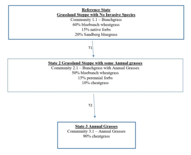
The south side of the Columbia Hills is a grassland steppe area and has not had sagebrush for more than 50 years and is not expected to have sagebrush. This area does not have sagebrush, nor bitterbrush, and no rabbitbrush except for one small area near the Columbia River.
Perennial bunchgrasses would dominate the reference state. Cool-season bunchgrasses form two distinct layers. Bluebunch wheatgrass is the dominant bunchgrass in the top grass layer, while Sandberg bluegrass is the major grass of the lower grass layer. Native forbs fill the interspaces.
Principle Vegetative Drivers:
The shallow soil depth and stones throughout the profile, and the south aspect drive the vegetative expression of this site. The soil depth limits deep-rooted species, plus the soil depth and stones limit the water holding capacity in the profile. Thus, plant production is quite limited for Shallow stony, south aspect, Columbia Hills sites.
Associated Sites:
Shallow Stony, south aspect, Columbia Hills is associated with other ecological sites in the grassland steppe area on the south side of the Columbia Hills including Loamy and Sands. Very Shallow may also be nearby.
Similar Sites:
Shallow Stony South Aspect Columbia Hills is a sparsely vegetated bluebunch wheatgrass site. Sagebrush is not present and other shrubs are nonexistent to only a trace.
The other sparsely vegetated Shallow Stony sites in MLRA 8 Columbia Plateau, MLRA 7 Columbia Basin and MLRA 6 East Slope of the Cascades all have sagebrush.
Associated sites
| R008XY536WA |
Loamy South Aspect Columbia Hills |
|---|
Similar sites
| R008XY226WA |
Stony Foothills South Aspect bitterbrush |
|---|---|
| R008XY120WA |
Stony sagebrush |
Table 1. Dominant plant species
| Tree |
Not specified |
|---|---|
| Shrub |
Not specified |
| Herbaceous |
(1) Pseudoroegneria spicata |
Click on box and path labels to scroll to the respective text.