Natural Resources
Conservation Service
Ecological site R008XY130WA
Loamy sagebrush sagebrush
Last updated: 5/23/2025
Accessed: 10/19/2025
General information
Provisional. A provisional ecological site description has undergone quality control and quality assurance review. It contains a working state and transition model and enough information to identify the ecological site.
MLRA notes
Major Land Resource Area (MLRA): 008X–Columbia Plateau
MLRA 8 encompasses about 50,100 square kilometers mainly in Washington and Oregon, with a small area in Idaho. This MLRA is characterized by loess hills, surrounding scablands, and alluvial deposits. This MLRA consists mostly of Miocene Columbia River Basalt covered with up to 200 feet of loess and volcanic ash. The dominant soil order in this MLRA is Mollisols. Soils in this MLRA dominantly have a mesic temperature regime, a xeric moisture regime, and mixed minerology.
Classification relationships
Major Land Resource Area (MLRA): 8 – Columbia Plateau
LRU – Common Resource Areas (CRA):
8.1 - Channeled Scablands
8.2 - Loess Islands
8.3 - Okanogan Drift Hills
8.4 - Moist Pleistocene Lake Basins
8.5 - Moist Yakima Folds
8.7 - Okanogan Valley
Ecological site concept
Note: For MLRA 8 there are four ecological sites with the name ‘Loamy’.
1. One for the sagebrush steppe region
2. One specifically for grasslands on Goldendale Prairie (Klickitat Co.)
3. One specifically for grasslands on south side of Columbia Hills (Klickitat Co.)
4. One for other grassland regions in MLRA 8
a. SE portion of MLRA 8 includes portions of Adams, Franklin, Walla Walla, Asotin, Columbia and Garfield counties
b. Area above Coulee Dam in Douglas Co.
The Loamy ESD below is for the sagebrush steppe areas of MLRA 8 (see 1 above).
Diagnostics:
This upland site occurs in the sagebrush region on 20 inches and deeper non-skeletal loamy soils. Soils have a loamy surface texture and limited rock fragments (generally 10 percent or less) in the root-growing portions of the soil profile. Silt loam, fine sandy loam and sandy loam are most common, but a variety of soils and landforms are possible.
As one moves across MLRA 8, the landscape position for Loamy changes. At 9 inches of precipitation Loamy occurs on all but the north to northeast slopes. But at 12 inches of precipitation Loamy may be found only on south to southwest slopes. Since Aridic soils in MLRA 8 are 9 to 12 inches of precipitation, Loamy could be considered an Aridic ecological site.
Fire-sensitive shrubs dominate the reference state overstory, while perennial bunchgrasses and forbs fill the interspaces. The shrub layer is typically waist- to shoulder-high Wyoming sagebrush. The natural fire regime maintains a patchy distribution of shrubs. Depending on the time interval since the last fire, the shrub canopy can be as little 0 to 3 percent or as much as 40 percent. Cool-season bunchgrasses form two distinct layers. Bluebunch wheatgrass is the dominant bunchgrass in the top grass layer, while Sandberg bluegrass is the major grass of the lower grass layer.
Disclaimer Statement:
Loamy, sagebrush ecological site concept covers a variety of soils and site conditions. There are at least four consistent and unifying factors across most of MLRA 8: (1) geology is largely basalt and loess, (2) soils are largely loessal, loess over basalt or loess-influenced, (3) similar climate of moderately cold, wet winters and hot, dry summers, and with limited precipitation, (4) dominant plant species (Wyoming sagebrush and bluebunch wheatgrass for example) that are adapted to a wide variety of soils and site conditions.
With the information and knowledge currently available, the technical team determined that site responses to disturbances, and species composition are similar enough to maintain a single Loamy ecological site across sagebrush steppe areas. If it is later determined that there are significant differences across the variation that must be addressed, this Loamy ecological site will be split into two or more separate ecological sites.
Associated sites
| R008XY536WA |
Loamy South Aspect Columbia Hills |
|---|---|
| R008XY455WA |
Loamy North Aspect 14-20 PZ Goldendale Prairie |
Similar sites
| R008XY630WA |
Loamy grassland |
|---|
Table 1. Dominant plant species
| Tree |
Not specified |
|---|---|
| Shrub |
(1) Artemisia tridentata ssp. wyomingensis |
| Herbaceous |
(1) Pseudoroegneria spicata |
Physiographic features
The landscape is part of the Columbia basalt plateau.
Physiographic Division: Intermontane Plateau
Physiographic Province: Columbia Plateau
Physiographic Sections: Walla Walla Plateau Section
Table 2. Representative physiographic features
| Geomorphic position, hills |
(1) Side Slope |
|---|---|
| Landforms |
(1)
Hills
(2) Valley (3) Plateau (4) Hillslope (5) Terrace (6) Bench (7) Alluvial fan |
| Flooding frequency | None |
| Ponding frequency | None |
| Elevation | 1,000 – 3,000 ft |
| Slope | 2 – 30% |
| Water table depth | 60 in |
| Aspect | W, NW, N, NE, E, SE, S, SW |
Table 3. Representative physiographic features (actual ranges)
| Flooding frequency | Not specified |
|---|---|
| Ponding frequency | Not specified |
| Elevation | 800 – 4,000 ft |
| Slope | 90% |
| Water table depth | Not specified |
Climatic features
The Wyoming sagebrush-bluebunch wheatgrass areas are both warmer and drier than grasslands or other shrub steppe sites (Daubenmire). The climate is characterized by moderately cold, wet winters, and hot, dry summers, with limited precipitation due to the rain shadow effect of the Cascades. Taxonomic soil climate is either xeric (12 to 16 inches PPT) or aridic moisture regimes (10 to 12 inches PPT) with a mesic temperature regime.
Table 4. Representative climatic features
| Frost-free period (characteristic range) | 120-160 days |
|---|---|
| Freeze-free period (characteristic range) | |
| Precipitation total (characteristic range) | 10-16 in |
| Frost-free period (actual range) | 90-210 days |
| Freeze-free period (actual range) | |
| Precipitation total (actual range) |
Influencing water features
With adequate cover of live plants and litter, there are no restrictions on Loamy sites with water infiltrating into the soil. These sites are well drained and are saturated for only a short period.
Soil features
This ecological site components are dominantly Aridic, Xeric, Calcic and Vitrandic taxonomic subgroups of Haploxerolls, Durixerolls, Palexerolls, Argixerolls and Haploxerepts great groups of the Mollisols and Inceptisols taxonomic orders, with Aridisols occurring as well. Soils are moderately deep to very deep. Average available water capacity of about 5.5 inches (14.0 cm) in the 0 to 40 inches (0-100 cm) depth range.
Soil parent material is dominantly mixed loess with influence of volcanic ash possible.
The associated soils are Alstown, Bagdad, Benwy, Caliralls, Cashmere, Colockum, Dougville, Ellisforde, Manastash, Mikkalo, Newbon, Palerf, Ralock, Renslow and similar soils.
Dominate soil surface is clay loam to very fine sandy loamy, with ashy modifier sometimes occurring as well.
Dominant particle-size class is fine to coarse-silty
Table 5. Representative soil features
| Parent material |
(1)
Loess
|
|---|---|
| Surface texture |
(1) Clay loam (2) Very fine sandy loam |
| Family particle size |
(1) Fine (2) Coarse-silty |
| Drainage class | Well drained to somewhat excessively drained |
| Depth to restrictive layer | 20 – 60 in |
| Soil depth | 20 – 60 in |
| Surface fragment cover <=3" | 10% |
| Surface fragment cover >3" | 5% |
| Available water capacity (0-40in) |
5.5 in |
| Calcium carbonate equivalent (Depth not specified) |
25% |
| Electrical conductivity (Depth not specified) |
10 mmhos/cm |
| Sodium adsorption ratio (Depth not specified) |
10 |
| Soil reaction (1:1 water) (0-10in) |
5.1 – 9.6 |
| Subsurface fragment volume <=3" (Depth not specified) |
15% |
| Subsurface fragment volume >3" (Depth not specified) |
10% |
Table 6. Representative soil features (actual values)
| Drainage class | Not specified |
|---|---|
| Depth to restrictive layer | Not specified |
| Soil depth | Not specified |
| Surface fragment cover <=3" | 30% |
| Surface fragment cover >3" | 30% |
| Available water capacity (0-40in) |
1.7 – 9.7 in |
| Calcium carbonate equivalent (Depth not specified) |
Not specified |
| Electrical conductivity (Depth not specified) |
Not specified |
| Sodium adsorption ratio (Depth not specified) |
Not specified |
| Soil reaction (1:1 water) (0-10in) |
Not specified |
| Subsurface fragment volume <=3" (Depth not specified) |
5 – 50% |
| Subsurface fragment volume >3" (Depth not specified) |
60% |
Ecological dynamics
Loamy, sagebrush produces about 600 to 1,200 pounds per acre of biomass annually.
Wyoming big sagebrush and bluebunch wheatgrass are at the core of the Loamy ecological site and warrant a degree of understanding.
Wyoming sagebrush in a long-lived, multi-branched, evergreen shrub. Size varies from 3 feet to 5 feet depending on soil and site conditions. Wyoming big sagebrush has a significant rooting system, composed of a two-part rooting structure with a primary deep taproot, and a shallow extensive network of finer roots that spread laterally. This rooting system allows Wyoming big sagebrush to survive in the hottest and driest portions of the sagebrush range by tapping into groundwater sources deep into the soil profile itself. This also allows Wyoming big sagebrush to be more competitive with bunchgrasses when the landscape positions and/or soils are less ideal for grass species to maintain the competitive advantage.
Bluebunch wheatgrass is a long-lived, mid-sized bunchgrass with an awned or awnless seed head arranged is a spike. Bluebunch provides a crucial and extensive network of roots to the upper portions (up to 48 inches deep in soils with no root-restrictive horizons) of the soil profile. These roots create a massive underground source to stabilize the soils, provide organic matter and nutrients inputs, and help maintain soil pore space for water infiltration and water retention in the soil profile. The extensive rooting system of mid-sized bunchgrasses leave very little soil niche space available for invasion by other species. This drought resistant root can compete with, and suppress, the spread of exotic weeds.
The stability and resiliency of the reference communities is directly linked to the health and vigor of bluebunch wheatgrass. Refer to page 8 for more details about bluebunch physiology. Research has found that the community remains resistant to medusahead invasion if the site maintains at least 0.8 mid-sized bunchgrass plants per square feet (K. Davies, 2008). It is bluebunch that holds the system together. If we lose the bluebunch the ecosystem crashes or unravels.
The natural disturbance regime for grassland communities is periodic lightning-caused fires. The fire return intervals (FRI) listed in research for sagebrush steppe communities is quite variable. Ponderosa pine communities have the shortest FRI of about 10 to 20 years (Miller). The FRI increases as one moves to wetter forested sites or to dries shrub steppe communities. Given the uncertainties and opinions of reviewers, a mean of 75 years and a range of 50 to 100 was chosen for Wyoming sagebrush communities (Rapid Assessment Model).
Some fires are spotty or do not burn hot enough to fully remove the sagebrush. Fires with light severity will remove less sagebrush and open smaller patches for grass and forb recovery, whereas the more severe fires will remove almost all the sagebrush and leave vast areas open to return to bunchgrass dominance. This is how the patchy distribution occurs. Rabbitbrush and horsebrush are sprouting shrubs and may also increase following fire.
The effect of fire on the community depends upon the severity of the burn. With a light to moderate fire there can be a mosaic of burned and unburned patches of sagebrush. Sagebrush can return to pre-burn conditions quickly. Bunchgrasses thrive as the fire does not get into the crown. With adequate soil moisture Idaho fescue and bluebunch wheatgrass can make tremendous growth the year after the fire. Other than impacting the sagebrush layer, the community is not affected.
A severe fire puts stress on the entire community. The sagebrush layer is completely removed. Spots or patches with heavy sagebrush are sterilized by the fire and must be seeded to prevent invasive species (annual grasses, tumble mustard) from totally occupying the site. Bluebunch wheatgrass and basin wildrye will have weak vigor for a few years but generally survive. Idaho fescue plants are very much at risk with a severe burn coupled with wind. The result can be “black holes” or ash 2 to 3 inches into the crown. The death of Idaho fescue plants creates holes in the community, and the opportunity for exotic species to colonize. Needle and thread is one native species that can increase via new seedlings.
For most of MLRA 8, Wyoming sagebrush does not recover easily after fire. The sagebrush in Douglas County, however, returns much more readily. For reasons that have not been clearly established, Douglas County may have a genetically different strain of sagebrush or be enough cooler and wetter, to receive more snowpack to get favorable responses. After disturbances sagebrush often becomes very dense and weedy in nature. Research indicates that microbes in the soil profile are essential for sagebrush success from seed.
The longer the site goes without fire and the more grazing pressure added, the more sagebrush cover increases, and the more bunchgrasses decline. As sagebrush cover increases bluebunch wheatgrass cover declines but individual plants may persist underneath the sagebrush. And, the dense sagebrush community phase is more vulnerable to outside pressures. Invasive species take advantage of available soil rooting spaces. The once extensive grass roots are largely absent. Soils are no longer receiving the organic inputs, and there is less surface cover by grass litter. Both water infiltration into the soil, and water percolation through the soil, are affected, leaving open soil space that is drier and more vulnerable to wind and water erosion, and invasion by undesirable species. Once these undesirable species have colonized, the site is at high risk of crossing a threshold if a disturbance such as fire were to occur.
Grazing is another common disturbance that occurs to this ecological site. Grazing pressure can be defined as heavy grazing intensity, or frequent grazing during reproductive growth, or season-long grazing (the same plant grazed more than once). As grazing pressure increases the plant community unravels in stages:
1. Cusick bluegrass, a highly desirable and palatable bunchgrass, declines and is eliminated. Adjacent native species fill the void.
2. Bluebunch wheatgrass declines while Sandberg bluegrass, needle and thread and sagebrush increase
3. As bluebunch wheatgrass continues to decline, invasive species such as cheatgrass and knapweed colonize the site
4. With further decline the site can become a sagebrush-cheatgrass community
Managing sagebrush steppe to improve the vigor and health of native bunchgrasses begins with an understanding of grass physiology. New growth each year begins from basal buds. Bluebunch wheatgrass plants rely principally on tillering, rather than establishment of new plants through natural reseeding. During seed formation, the growing points become elevated and are vulnerable to damage or removal.
If defoliated during the formation of seeds, bluebunch wheatgrass has limited capacity to tiller compared with other, more grazing resistant grasses (Caldwell et al., 1981). Repeated critical period grazing (boot stage through seed formation) is especially damaging. Over several years each native bunchgrass pasture should be rested during the critical period two out of every three years (approximately April 15 to July 15). And each pasture should be rested the entire growing-season every third year (approximately March 1 to July 15).
In the spring each year it is important to monitor and maintain an adequate top growth: (1) so plants have enough energy to replace basal buds annually, (2) to optimize regrowth following spring grazing, and (3) to protect the elevated growing points of bluebunch wheatgrass.
Bluebunch wheatgrass remains competitive if:
(1) Basal buds are replaced annually,
(2) Enough top-growth is maintained for growth and protection of growing points, and
(3) The timing of grazing and non-grazing is managed over a several-year period. Careful management of late spring grazing is especially critical
For more grazing management information refer to Range Technical Notes found in Section I Reference Lists of NRCS Field Office Technical Guide for Washington State.
In Washington, Wyoming sagebrush – bluebunch wheatgrass communities provide habitat for a variety of upland wildlife species.
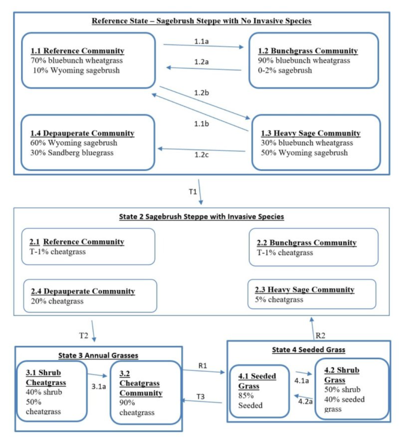
State and transition model
More interactive model formats are also available.
View Interactive Models
More interactive model formats are also available.
View Interactive Models
Click on state and transition labels to scroll to the respective text
State 1 submodel, plant communities
State 2 submodel, plant communities
State 3 submodel, plant communities
State 4 submodel, plant communities
State 1
Reference
State 1 represents sagebrush steppe with no invasive or exotic weed species. All the functional, structural groups have one or more native species. A diverse native perennial community is more resistant to invasive annual species such as cheatgrass. Reference State Communities: 1.1 Reference Bluebunch Wheatgrass and Wyoming Sagebrush, 1.2 Bunchgrass, 1.3 Heavy sagebrush, and 1.4 Depauperate. Dominant Reference State Species: Wyoming big sagebrush, bluebunch wheatgrass. At-risk Communities: • All communities in the Reference state are at risk of moving to State 2. The seed source of cheatgrass is nearby and blowing onto most sites annually • Community 1.4, the depauperate community (sagebrush-Sandberg bluegrass), has little to no bluebunch wheatgrass, and is therefore, at considerable risk of moving to State 3 which is dominated by annual species. • Any Loamy community is at risk when bluebunch cover is low (less than 10 percent) and cheatgrass cover is becoming co-dominant (40 percent or more). • Any community is at risk when sagebrush cover is high (greater than 40 percent) and there is little to no bluebunch • Community 1.4, and any site with low cover of bluebunch wheatgrass, and any site with moderate to heavy cover of cheatgrass should be seeded after a fire.
Community 1.1
Reference - Bluebunch Wheatgrass and Wyoming Big Sagebrush
Reference Community 1.1 is dominated by bluebunch wheatgrass with some sagebrush. Communities 1.1, 1.2, and 1.3 have enough bluebunch wheatgrass to shift to the other two communities and back again. These three communities have high amounts of bunchgrass cover and are at low risk of moving to State 3
Figure 1. Annual production by plant type (representative values) or group (midpoint values)
Community 1.2
Bunchgrass
Community 1.2 is even more strongly bunchgrass dominated.
Community 1.3
Heavy Sagebrush
Community 1.3 has a heavy sagebrush canopy but bluebunch remains a vital component in the community.
Community 1.4
Depauperate
Community 1.4, Depauperate, is dominated by sagebrush with Sandberg bluegrass as sub-dominate. The are no invasive species in Community 1.4, but there is not enough bluebunch wheatgrass remaining for Community 1.4 to shift back to the other communities in the Reference state.
Pathway 1.1A
Community 1.1 to 1.2
Result: Shift from the Reference community to the Bunchgrass community. Sagebrush cover is all but eliminated, while bluebunch wheatgrass has a moderate increase. The community shifts from a shrub steppe to a bunchgrass appearance. Primary Trigger: Moderate-severity fire consumes above-ground plant biomass and kills almost all the sagebrush. For bunchgrasses and forbs there is no impact to their crowns and these species return post-fire with good vigor. Post-fire the bunchgrasses are now more susceptible to grazing damage. Burned rangeland pastures will need two growing seasons recovery prior to resuming grazing, or to be lightly grazed but only during dormant season the first two years post-fire. Beyond two years for the bunchgrasses to expand, the grazing plan must promote light to moderate grazing intensity, and both critical period and growing season deferments must be implemented on burned pastures. Ecological process: Fire kills sagebrush and it does not have any sprouting ability. A few sagebrush plants remain, but only in patches that did not burn. The reduction in sagebrush releases resources and increases light for grasses and forbs. Bluebunch wheatgrass and other bunchgrasses have good vigor post-fire and expand via tillering and new seedlings.
Pathway 1.1B
Community 1.1 to 1.3
Result: shift from the Reference community to the Heavy Sagebrush community. There is a moderate increase in sagebrush while bluebunch wheatgrass has a corresponding moderate decrease. Primary Trigger: With excessive grazing pressure (heavy grazing intensity, season long grazing or frequent late spring grazing) and a period of no fire, sagebrush increases its cover while bluebunch wheatgrass suffers a big decline. Ecological process: Due to consistent defoliation pressure bluebunch wheatgrass has low vigor, shrinking crowns and some mortality. This gives sagebrush the opportunity to set new seedlings and expand its cover. Increased shade from the new sagebrush plants also plays a role in this process.
Pathway 1.2A
Community 1.2 to 1.1
Result: Shift from bunchgrass community to reference community. There is a moderate reduction of bluebunch wheatgrass cover and a minor increase of sagebrush. Primary Trigger: Over time with no fire, sagebrush will re-enter the community even with good bunchgrass vigor. Ecological process: Spots with soil disturbance receive sagebrush seed from remnant plants in unburned patches or from adjacent sites, seed germinates in the spring and a few sagebrush seedlings establish. For most locations it may take up to 10 years for sagebrush to re-enter the community. But in Douglas County the re-entry period may only be two to five years. With a slight increase in shade perennial bunchgrasses experience a slight decline.
Pathway 1.3A
Community 1.3 to 1.1
Result: Shift from the Heavy Sagebrush community to the Reference community. There is a major decrease in sagebrush cover and a considerable increase in the cover of bluebunch wheatgrass. The community shift is from sagebrush dominance to bunchgrass dominance. Primary Trigger: Moderate-severity fire is patchy, dependent on temperature, wind, fuel load and fuel moisture. In areas that burn the fire is complete enough and hot enough to remove most sagebrush. Fire conditions and post-fire grazing management allows bluebunch wheatgrass and other bunchgrasses to thrive and expand. Some areas burn complete while other areas are unburned to lightly burned and fire is not hot enough to affect soil conditions. Fire removes surface vegetation but has no impact on the root crown of bunchgrasses. So, bunchgrasses and forbs return post-fire with good vigor. Post-fire the bunchgrasses are now more susceptible to grazing damage. Burned rangeland pastures will need two growing seasons recovery prior to resuming grazing, or to be lightly grazed but only during dormant season the first two years post-fire. Beyond two years, for the bunchgrasses to expand, the grazing plan must moderate grazing intensity, and both critical period and growing season deferments must be implemented on burned pastures. Ecological process: Fire kills sagebrush and it does not have any sprouting ability. Some sagebrush remains, but only in patches that did not burn. The reduction in sagebrush releases resources and increases light for grasses and forbs. Bluebunch wheatgrass and other bunchgrasses have good vigor post-fire and expand via tillering and new seedlings
Pathway 1.3B
Community 1.3 to 1.4
Result: Shift from the Heavy sagebrush community to the Depauperate community. Sagebrush has a moderate increase while bluebunch is all but eliminated from the community. Invasive annual grasses have not invaded, but Community 1.4 is most at risk to invasion and is the segue between States 1 and 2, and States 1 and 3. Pathway 1.2C is a continuation of the process that started with Pathway 1.2B. Primary Trigger: With excessive grazing pressure (heavy grazing intensity, season long grazing or frequent late spring grazing) and a period of no fire, sagebrush increases its cover while bluebunch wheatgrass bunchgrasses suffers a big decline. Grazing animals selectively target the remaining bluebunch wheatgrass plants eliminating most of the bluebunch wheatgrass plants from the community. Ecological process: Due to consistent defoliation pressure bluebunch wheatgrass has low vigor, shrinking crowns and a lot of mortality giving sagebrush opportunity to set new seedlings and expand its cover. A few bluebunch wheatgrass plants may survive.
State 2
Sagebrush Steppe with Invasive Species
State 2 represents a gradation along the transition between Reference state and State 3. State 2 is sagebrush steppe with the inclusion of invasive annual grasses such as cheatgrass. All the native functional, structural groups are still represented by one or more species. Cheatgrass seed blows onto most sites annually seeking an opportunity to invade and colonize. With each loss of a native perennial plant, the site becomes less and less resistant to invasion. When cheatgrass makes seed for the next generation, the site has been colonized and will likely remain a component of the community. The loss of biological soil crusts is also a contributing factor to the invasion by cheatgrass. For communities 2.1, 2.2, and 2.3 the amount of cheatgrass is minor. Cheatgrass is more prominent in community 2.4. Once a community has been invaded by cheatgrass the chance of going back to State 1 is small. This state can occur with or without sagebrush. Community Phases for State 2: Same as Reference State. Dominant State 2 Species: Wyoming big sagebrush – bluebunch wheatgrass Pathways within State 2 The pathways in State 2 are basically the same as in the Reference State. Community 2.4 is most at risk of transitioning to State 3.
Community 2.1
Reference with Invasives
Reference with Invasives community 2.1 is dominated by bluebunch wheatgrass with some sagebrush and minimal invasive speceis. Communities 2.1, 2.2, and 2.3 have enough bluebunch wheatgrass to shift to the other two communities and back again. These three communities have high amounts of bunchgrass cover and are at low risk of moving to State 3.
Community 2.2
Bunchgrass with Invasives
Community 2.2 is even more strongly bunchgrass dominated but contains invasives species.
Community 2.3
Heavy Sagebrush with Invasives
Community 2.3 has a heavy sagebrush canopy but bluebunch remains a vital component in the community. Invasive species are present.
Community 2.4
Depauperate with Invasives
Community 2.4, Depauperate with Invasives, is dominated by sagebrush with Sandberg bluegrass as sub-dominate with invasive species present. There is not enough bluebunch wheatgrass remaining for Community 2.4 to shift back to the other communities in this state.
Pathway 2.1A
Community 2.1 to 2.2
Result: Shift from the Reference with Invasives community to the Bunchgrass with Invasives community. Sagebrush cover is all but eliminated, while bluebunch wheatgrass has a moderate increase. The community shifts from a shrub steppe to a bunchgrass appearance. Primary Trigger: Moderate-severity fire consumes above-ground plant biomass and kills almost all the sagebrush. For bunchgrasses and forbs there is no impact to their crowns and these species return post-fire with good vigor. Post-fire the bunchgrasses are now more susceptible to grazing damage. Burned rangeland pastures will need two growing seasons recovery prior to resuming grazing, or to be lightly grazed but only during dormant season the first two years post-fire. Beyond two years for the bunchgrasses to expand, the grazing plan must promote light to moderate grazing intensity, and both critical period & growing season deferments must be implemented on burned pastures. Ecological process: Fire kills sagebrush and it does not have any sprouting ability. A few sagebrush plants remain, but only in patches that did not burn. The reduction in sagebrush releases resources and increases light for grasses and forbs. Bluebunch wheatgrass and other bunchgrasses have good vigor post-fire and expand via tillering and new seedlings.
Pathway 2.1B
Community 2.1 to 2.3
Result: shift from Reference with Invasives community to Heavy Sagebrush with Invasives community. There is a moderate increase in sagebrush while bluebunch wheatgrass has a corresponding moderate decrease. Primary Trigger: With excessive grazing pressure (heavy grazing intensity, season long grazing or frequent late spring grazing) and a period of no fire, sagebrush increases its cover while bluebunch wheatgrass suffers a big decline. Ecological process: Due to consistent defoliation pressure bluebunch wheatgrass has low vigor, shrinking crowns and some mortality. This gives sagebrush the opportunity to set new seedlings and expand its cover. Increased shade from the new sagebrush plants also plays a role in this process.
Pathway 2.2A
Community 2.2 to 2.1
Result: Shift from the Bunchgrass with Invasives community to Reference with Invasives community. There is a moderate reduction of bluebunch wheatgrass cover and a minor increase of sagebrush. Primary Trigger: Over time with no fire, sagebrush will re-enter the community even with good bunchgrass vigor. Ecological process: Spots with soil disturbance receive sagebrush seed from remnant plants in unburned patches or from adjacent sites, seed germinates in the spring and a few sagebrush seedlings establish. For most locations it may take up to 10 years for sagebrush to re-enter the community. But in Douglas County the re-entry period may only be two to five years. With a slight increase in shade perennial bunchgrasses experience a slight decline.
Pathway 2.3A
Community 2.3 to 2.1
Result: Shift from the Heavy Sagebrush community to the Reference with Invasives community. There is a major decrease in sagebrush cover and a considerable increase in the cover of bluebunch wheatgrass. The community shift is from sagebrush dominance to bunchgrass dominance. Primary Trigger: Moderate-severity fire is patchy, dependent on temperature, wind, fuel load and fuel moisture. In areas that burn the fire is complete enough and hot enough to remove most sagebrush. Fire conditions and post-fire grazing management allows bluebunch wheatgrass and other bunchgrasses to thrive and expand. Some areas burn complete while other areas are unburned to lightly burned and fire is not hot enough to affect soil conditions. Fire removes surface vegetation but has no impact on the root crown of bunchgrasses. So, bunchgrasses and forbs return post-fire with good vigor. Post-fire the bunchgrasses are now more susceptible to grazing damage. Burned rangeland pastures will need two growing seasons recovery prior to resuming grazing, or to be lightly grazed but only during dormant season the first two years post-fire. Beyond two years, for the bunchgrasses to expand, the grazing plan must moderate grazing intensity, and both critical period & growing season deferments must be implemented on burned pastures. Ecological process: Fire kills sagebrush and it does not have any sprouting ability. Some sagebrush remains, but only in patches that did not burn. The reduction in sagebrush releases resources and increases light for grasses and forbs. Bluebunch wheatgrass and other bunchgrasses have good vigor post-fire and expand via tillering and new seedlings
Pathway 2.3B
Community 2.3 to 2.4
Result: Shift from Heavy Sagebrush with Invasives community to Depauperate with Invasives community. Sagebrush has a moderate increase while bluebunch is all but eliminated from the community. Primary Trigger: With excessive grazing pressure (heavy grazing intensity, season long grazing or frequent late spring grazing) and a period of no fire, sagebrush increases its cover while bluebunch wheatgrass bunchgrasses suffers a big decline. Grazing animals selectively target the remaining bluebunch wheatgrass plants eliminating most of the bluebunch wheatgrass plants from the community. Ecological process: Due to consistent defoliation pressure bluebunch wheatgrass has low vigor, shrinking crowns and a lot of mortality giving sagebrush opportunity to set new seedlings and expand its cover. A few bluebunch wheatgrass plants may survive.
State 3
Annual Grasses
State 3 represents communities dominated by invasive annual species and has crossed a biological threshold. Virtually all the native functional, structural groups are missing. This state can occur with or without sagebrush. Community Phases for State 3: 3.1 Shrub – Annual Grass Sagebrush – cheatgrass 3.2 Annual Grass Cheatgrass Dominate State 3 Species: Cheatgrass with or without sagebrush The main species can include cheatgrass, Japanese brome, medusahead, ventenata, mustard, prickly lettuce and diffuse knapweed. This state can occur with or without sagebrush.
Community 3.1
Shrub Cheatgrass
50% shrub 40% annual grass
Community 3.2
Cheatgrass
90% annual grass
Pathway 3.1A
Community 3.1 to 3.2
Result: shift from shrub-cheatgrass to cheatgrass. Causes: Moderate intensity fire kills most or all sagebrush. Ecological Process: With the shrubs mostly eliminated, and with few native herbaceous species remaining, invasive species have no competition and totally dominate the community.
State 4
Seeded Grass
State 4 represents a site that has been seeded to desirable grasses such as Secar Snake River wheatgrass, Sherman big bluegrass, crested wheatgrass or intermediate wheatgrass. State 4 has two community phases that are stable if they maintain 0.8 plants per square feet or greater of the desired bunchgrasses. Communities for State 4: 4.1 Seeded Grasses 4.2 Shrub and Seeded Grass Dominant State 4 Species: Desirable seeded grasses with or without sagebrush and legumes
Community 4.1
Seeded Grass
85% seeded grass
Community 4.2
Shrubs and Seeded Grass
50% shrub 40% seeded grass
Pathway 4.1A
Community 4.1 to 4.2
Result: Shift from the Seeded Grass community to the Shrub and Seeded Grass community. Shrubs colonize the site and increase cover and density while seeded grasses decline Causes: Heavy grazing pressure on seeded grasses reduce their plant vigor. Ecological process: Consistent defoliation pressures that reduced plant vigor to such a degree that that grass roots begin to die, bunchgrass crowns shrink, and some seeded grasses die. This opens the soil for seedling shrubs to establish.
Pathway 4.2A
Community 4.2 to 4.1
Result: Shift from the Shrub and Seeded Grass community to the Seeded Grass community. Shrubs are decreased to all but eliminated and grasses increase to dominate the community. Causes: (1) For communities with fire sensitive shrubs (sagebrush, bitterbrush) and a good population of desirable grasses, the best course of action is to reduce the shrubs by fire, chemical or mechanical treatment, and to use proper grazing management to ensure grasses can expand its cover. (2) For communities with fire tolerant shrubs (rabbitbrush, three-tip sage) and a good population of desirable grasses, the best course of action is to reduce the shrubs by chemical treatment and to use proper grazing management to ensure grasses can expand its cover. (3) Communities that do not have much remaining seeded grasses will require a seedbed to be prepared and a seeding operation. Seedbed preparation can use a combination of fire, mechanical tillage and chemical application. Post-seeding the site will need 2 growing seasons of rest while the seeded grasses are established. Broadleaf weed control may also be necessary. Afterward, proper grazing must be used to maintain the stand. Ecological Process: with removal of the shrub layer the vigorous seeded grasses increase via tillering and new seedlings
Transition T1A
State 1 to 2
Result: transition from Reference State to State 2 (shrub steppe w/ a few annuals). The Reference State does not have invasive species. State 2 has the same communities but with minor additions of invasive annual grasses such as cheatgrass. Ecological process. Most sites in the Reference State have some scattered cheatgrass seed. This seed is waiting for enough moisture to germinate and to compete with the native species for space, light and moisture. When the right year happens even pristine communities in the Reference State are susceptible to colonization by cheatgrass. Primary Trigger: The transition occurs during a high moisture year that causes a micro-burst of cheatgrass and is the principle means of colonization. A second trigger would be spots of soil disturbance. Indicators: The occurrence of annual grasses on sites where they had been absent.
Transition T2A
State 2 to 3
Result: Transition from State 2 to State 3 which is dominated by annuals. This transition occurs once the cover of bluebunch wheatgrass decline to less than 10% while invasive species cover is 40 percent or more. Primary Trigger: Chronic heavy grazing, season-long grazing, or late spring grazing. Note: chronic season-long grazing in 1880s to 1940s created thousands of acres of annual grass-sagebrush community, and then fire turned that into annual grasses. Ecological Process: Consistent defoliation pressure to bluebunch wheatgrass causes poor vigor, shrinking crowns and plant mortality. Native species are all but eliminated while invasive species such as annual bromes have the competitive advantage. With more and more of the soil surface and upper soil rooting surface open, opportunistic, exotic weeds take advantage of the available niche space to colonize and expand until they dominate the community. The site has lost its primary species that stabilize and protect the soil from wind and water erosion and has also lost the ability to retain sufficient soil moisture for many of the native perennial species. Indicators: Decreasing cover of bluebunch wheatgrass and increasing cover of invasive annual species. Increasing distance between bunchgrass plants. Decreasing soil organic matter, soil water retention, limited water infiltration and percolation in the soil profile.
Restoration pathway R3A
State 3 to 4
This restoration transition does not occur without significant time and inputs to control weeds, prepare a seedbed, seed the desirable species, and post-seeding, to control weeds and manage grazing. This requires a commitment of two years or more for weed control and seedbed preparation. Care must be taken to maintain soil structure so that the seedbed has many safe-sites for the seed. Seed placement must be managed to achieve seed-soil contact at very shallow depth (about 1/8 inch is desired). Proper grazing management is essential to maintain the stand post-seeding. Secar Snake River wheatgrass, thickspike wheatgrass, Sherman big bluegrass, Sandberg bluegrass, and crested or intermediate wheatgrass are typical species seeded on Loamy ecological site. The actual transition occurs when the seeded species have successfully established and are outcompeting the annual species for cover and dominance of resources.
Restoration pathway R4A
State 4 to 2
Result: Shift from State 3 back to State 2. This restoration transition does not occur without a significant commitment of time & resource inputs to restore ecological processes, native bunchgrasses, Wyoming sagebrush and native forb species. Shifting from State 3 to State 4: If the goal is to restore back to a native plant community, State 3 must first be shifted to State 4. It will take two years or longer to kill annual species and to exhaust the seedbank of invasive species. Site will then need to be seeded to perennial species such as crested wheatgrass to restore soil properties before native species can survive and thrive on site. The seeded species rebuild some of the basic soil properties including increased soil organic matter, increased soil moisture, and likely would also require the soil’s pore spaces, bulk density and soil microorganisms to return before the native species that used to survive in this ecological site can return. The site would also need several years of no significant fires and proper grazing management as well to establish and maintain desirable species plant vigor. See narrative for R1 transition above. Shifting from State 4 to State 2: This assumes that the shift from State 3 to State 4 has been successful. Introduce grasses must be killed before native species are seeded. The seeding of native species should occur in two steps: (1) a seeding of native bunchgrasses so that broadleaf weeds may be controlled, (2) a re-introduction of sagebrush and native forbs. The site would also need several years of no significant fires and proper grazing management as well to ensure plant establishment and vigor. See narrative for R1 transition above.
Transition T4A
State 4 to 3
Result: shift from seeded grass State 4 to State 3 which is dominated by invasive annual species. Primary Trigger: This transition occurs when chronic grazing pressure has removed too much of the seeded bunchgrass cover allowing invasive annual species to colonize the site. As this continues the competitive advantage goes to the exotic species which are opportunistic and take most of the site’s resources. Little of the resources remain for the desirable species. Secondary Trigger: Frequent fires or a severe fire that removes too much of the perennial bunchgrass cover and gives the competitive advantage back to the invasive species. Ecological Process: Consistent defoliation pressure to seeded grasses cause poor vigor, shrinking crowns and plant mortality. With more and more of the soil surface and upper soil rooting surface open, opportunistic, exotic weeds that take advantage of the available niche space to colonize and expand until the dominate the community. Indicators: shrinking crowns and mortality of desirable species, increasing gaps between seeded plants, and increasing cover by annual grasses.
Additional community tables
Table 7. Community 1.1 plant community composition
| Group | Common name | Symbol | Scientific name | Annual production (lb/acre) | Foliar cover (%) | |
|---|---|---|---|---|---|---|
|
Shrub/Vine
|
||||||
| 1 | Non-Sprouting Shrubs - Subdominant | 90–120 | ||||
| Wyoming big sagebrush | ARTRW8 | Artemisia tridentata ssp. wyomingensis | – | – | ||
| basin big sagebrush | ARTRT | Artemisia tridentata ssp. tridentata | – | – | ||
| antelope bitterbrush | PUTR2 | Purshia tridentata | – | – | ||
| 2 | Sprouting Shrubs - Minor | 20–50 | ||||
| rabbitbrush | CHRYS9 | Chrysothamnus | – | – | ||
| currant | RIBES | Ribes | – | – | ||
| rose | ROSA5 | Rosa | – | – | ||
|
Grass/Grasslike
|
||||||
| 3 | Dominant Mid-Size Bunchgrasses | 650–850 | ||||
| bluebunch wheatgrass | PSSP6 | Pseudoroegneria spicata | – | – | ||
| 4 | Other Mid-Size Bunchgrasses - Minor | 20–50 | ||||
| Idaho fescue | FEID | Festuca idahoensis | – | – | ||
| squirreltail | ELEL5 | Elymus elymoides | – | – | ||
| Thurber's needlegrass | ACTH7 | Achnatherum thurberianum | – | – | ||
| needle and thread | HECO26 | Hesperostipa comata | – | – | ||
| Columbia needlegrass | ACNE9 | Achnatherum nelsonii | – | – | ||
| 5 | Short Grass - Minor | 90–120 | ||||
| Sandberg bluegrass | POSE | Poa secunda | – | – | ||
|
Forb
|
||||||
| 6 | Native Forbs - Minor | 90–120 | ||||
| arrowleaf balsamroot | BASA3 | Balsamorhiza sagittata | – | – | ||
| lupine | LUPIN | Lupinus | – | – | ||
| hawksbeard | CREPI | Crepis | – | – | ||
| longleaf phlox | PHLO2 | Phlox longifolia | – | – | ||
| spiny phlox | PHHO | Phlox hoodii | – | – | ||
| granite prickly phlox | LIPU11 | Linanthus pungens | – | – | ||
| buckwheat | ERIOG | Eriogonum | – | – | ||
| Indian paintbrush | CASTI2 | Castilleja | – | – | ||
| common yarrow | ACMI2 | Achillea millefolium | – | – | ||
| fleabane | ERIGE2 | Erigeron | – | – | ||
| desertparsley | LOMAT | Lomatium | – | – | ||
| milkvetch | ASTRA | Astragalus | – | – | ||
| woolly plantain | PLPA2 | Plantago patagonica | – | – | ||
| western stoneseed | LIRU4 | Lithospermum ruderale | – | – | ||
| mariposa lily | CALOC | Calochortus | – | – | ||
| trumpet | COLLO | Collomia | – | – | ||
| low pussytoes | ANDI2 | Antennaria dimorpha | – | – | ||
| silverpuffs | MICRO6 | Microseris | – | – | ||
Interpretations
Supporting information
Other references
Boling M., Frazier B., Busacca, A., General Soil Map of Washington, Washington State University, 1998 Daubenmire, R., Steppe Vegetation of Washington, EB1446, March 1968
Davies, Kirk, Medusahead Dispersal and Establishment in Sagebrush Steppe Plant Communities, Rangeland Ecology & Management, 2008 Environmental Protection Agency, map of Level III and IV Ecoregions of Washington, June 2010
Miller, Baisan, Rose and Pacioretty, “Pre and Post Settlement Fire regimes in mountain Sagebrush communities: The Northern Intermountain Region Natural Resources Conservation Service, map of Common Resource Areas of Washington, 2003 Rapid Assessment Reference Condition Model for Wyoming sagebrush, LANDFIRE project, 2008
Rocchio, Joseph & Crawford, Rex C., Ecological Systems of Washington State. A Guide to Identification. Washington State Department of Natural Resources, October 2015. Pages 156-161 Inter-Mountain Basin Big Sagebrush
Rouse, Gerald, MLRA 8 Ecological Sites as referenced from Natural Resources Conservation Service-Washington FOTG, 2004 Soil Conservation Service, Range Sites for MLRA 8 from 1980s and 1990s
Tart, D., Kelley, P., and Schlafly, P., Rangeland Vegetation of the Yakima Indian reservation, August 1987, YIN Soil and Vegetation Survey
Contributors
Kevin Guinn
K. Moseley
G. Fults
R. Fleenor
W. Keller
C. Smith
K. Bomberger
C. Gaines
K. Paup-Lefferts
Approval
Kirt Walstad, 5/23/2025
Acknowledgments
Provisional Site Author: Kevin Guinn
Technical Team: K. Moseley, G. Fults, R. Fleenor, W. Keller, C. Smith, K. Bomberger, C. Gaines, K. Paup-Lefferts
Rangeland health reference sheet
Interpreting Indicators of Rangeland Health is a qualitative assessment protocol used to determine ecosystem condition based on benchmark characteristics described in the Reference Sheet. A suite of 17 (or more) indicators are typically considered in an assessment. The ecological site(s) representative of an assessment location must be known prior to applying the protocol and must be verified based on soils and climate. Current plant community cannot be used to identify the ecological site.
| Author(s)/participant(s) | |
|---|---|
| Contact for lead author | |
| Date | 03/31/2025 |
| Approved by | Kirt Walstad |
| Approval date | |
| Composition (Indicators 10 and 12) based on | Annual Production |
Indicators
-
Number and extent of rills:
-
Presence of water flow patterns:
-
Number and height of erosional pedestals or terracettes:
-
Bare ground from Ecological Site Description or other studies (rock, litter, lichen, moss, plant canopy are not bare ground):
-
Number of gullies and erosion associated with gullies:
-
Extent of wind scoured, blowouts and/or depositional areas:
-
Amount of litter movement (describe size and distance expected to travel):
-
Soil surface (top few mm) resistance to erosion (stability values are averages - most sites will show a range of values):
-
Soil surface structure and SOM content (include type of structure and A-horizon color and thickness):
-
Effect of community phase composition (relative proportion of different functional groups) and spatial distribution on infiltration and runoff:
-
Presence and thickness of compaction layer (usually none; describe soil profile features which may be mistaken for compaction on this site):
-
Functional/Structural Groups (list in order of descending dominance by above-ground annual-production or live foliar cover using symbols: >>, >, = to indicate much greater than, greater than, and equal to):
Dominant:
Sub-dominant:
Other:
Additional:
-
Amount of plant mortality and decadence (include which functional groups are expected to show mortality or decadence):
-
Average percent litter cover (%) and depth ( in):
-
Expected annual annual-production (this is TOTAL above-ground annual-production, not just forage annual-production):
-
Potential invasive (including noxious) species (native and non-native). List species which BOTH characterize degraded states and have the potential to become a dominant or co-dominant species on the ecological site if their future establishment and growth is not actively controlled by management interventions. Species that become dominant for only one to several years (e.g., short-term response to drought or wildfire) are not invasive plants. Note that unlike other indicators, we are describing what is NOT expected in the reference state for the ecological site:
-
Perennial plant reproductive capability:
Print Options
Sections
Font
Other
The Ecosystem Dynamics Interpretive Tool is an information system framework developed by the USDA-ARS Jornada Experimental Range, USDA Natural Resources Conservation Service, and New Mexico State University.
Click on box and path labels to scroll to the respective text.